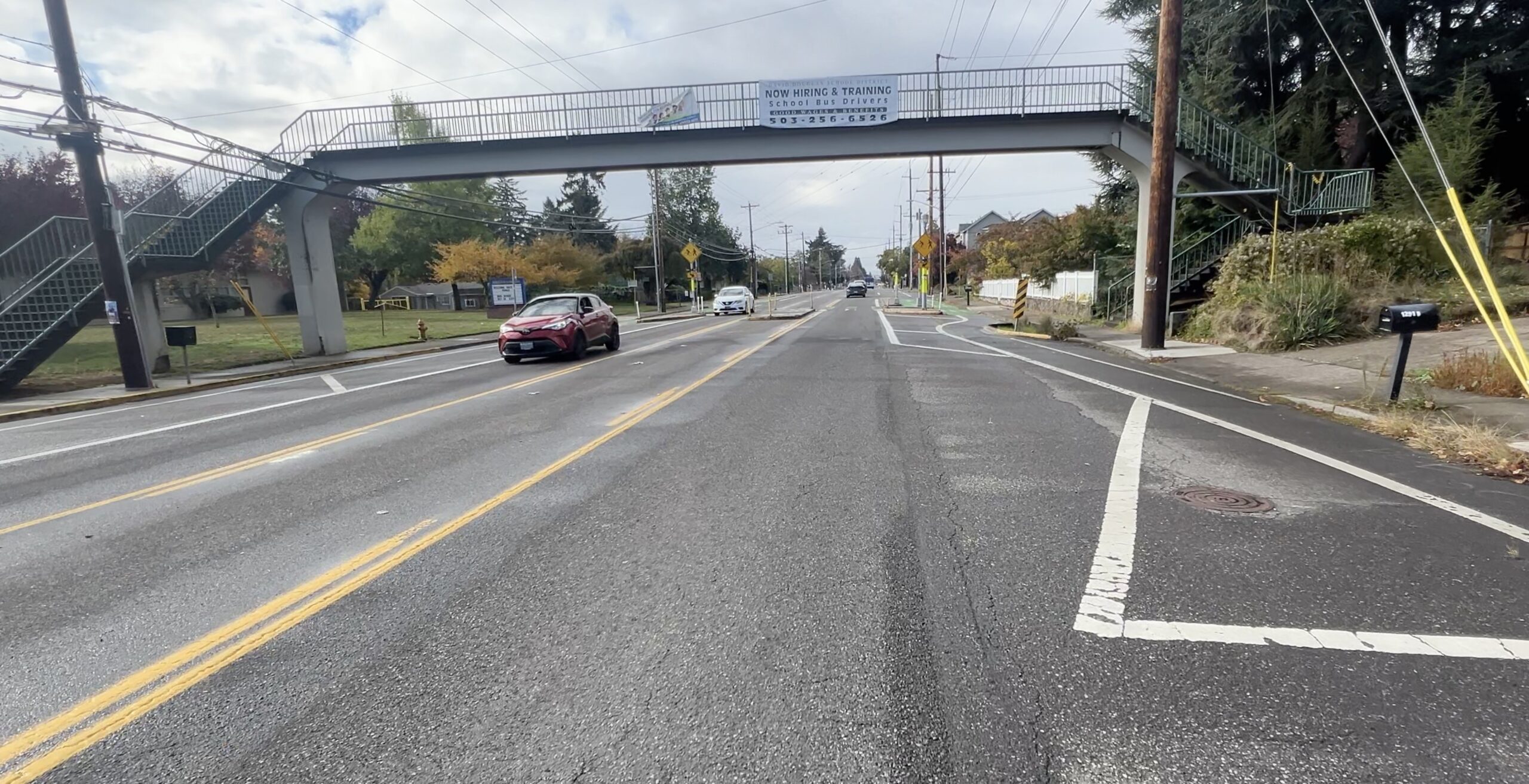
Multnomah County announced this morning that their major maintenance project on the Hawthorne Bridge is complete. This is the project that made several big changes to the all-important bikeway on what has historically been one of the busiest bikeways not just in the city, but in the entire country.
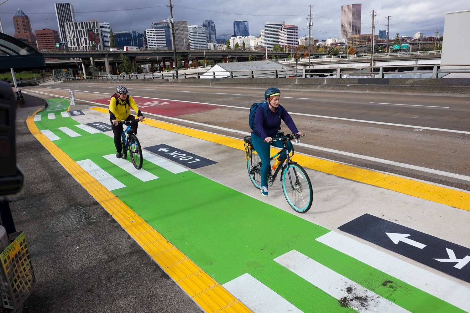
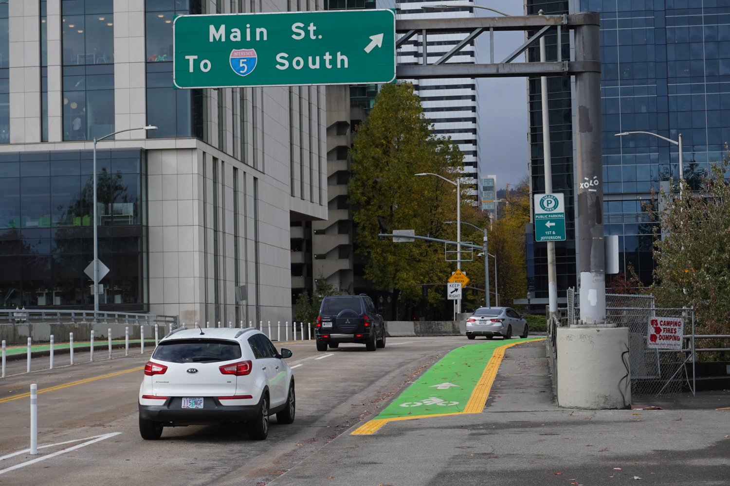
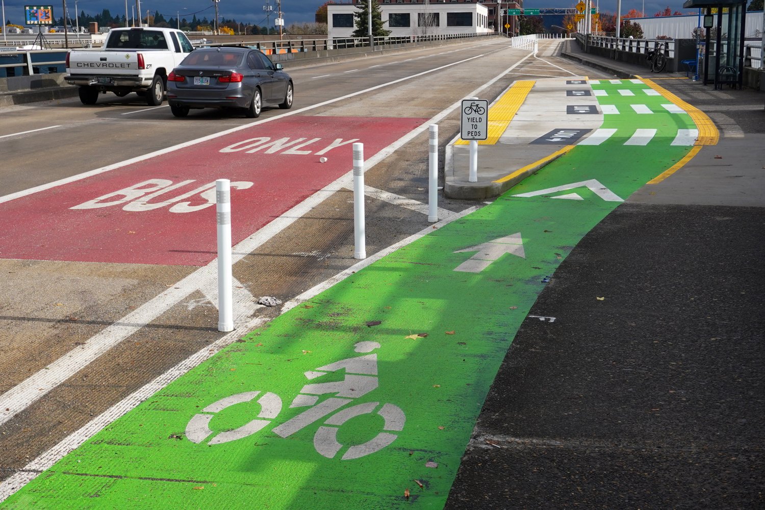
There are three main pieces of this project that impact the bikeway: A new section of above-grade bike lane in the westbound direction that leads onto SW 1st and Main; a new bus island bikeway in the eastbound direction on the viaduct; and an update to the striping where the double-wide bike lane crossing the SE Clay/Martin Luther King Jr. Blvd off-ramp.
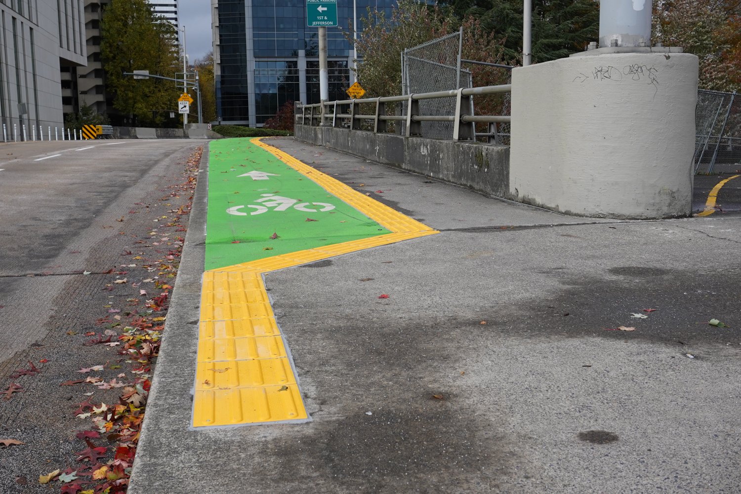
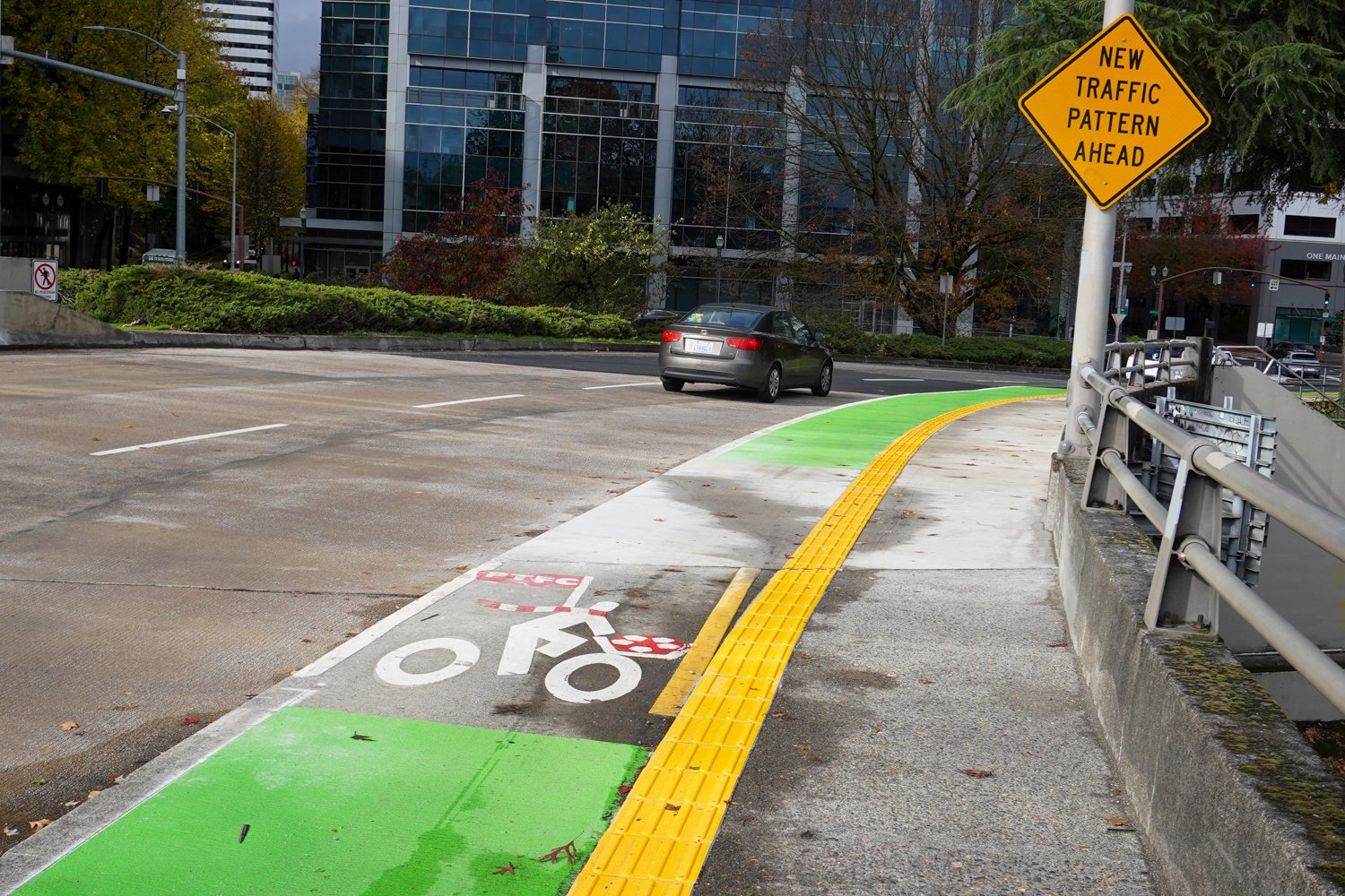
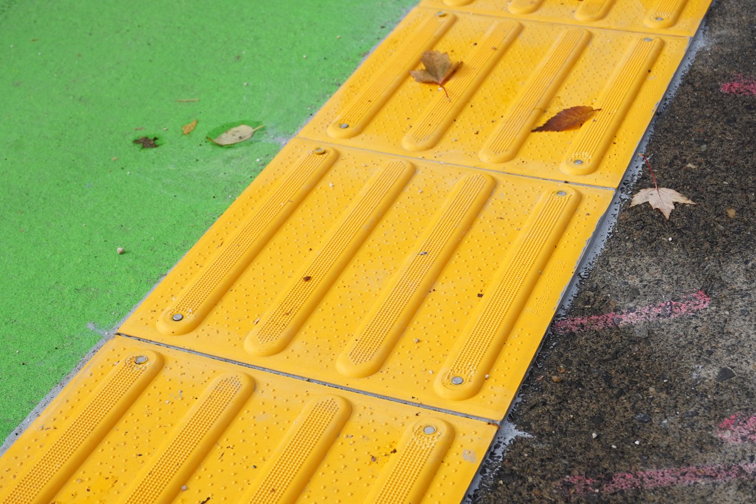
The new eastbound bike lane is more integrated with riding conditions on the rest of the bridge and riders are no longer foisted onto the road next to car users. To help manage the mix between bike users and walkers, the county uses a bright yellow material that’s grooved and dimpled. This acts as both a visual and physical cue to use caution in these areas and will hopefully keep folks in the right places. Any time I see grooves going in any angle that’s not perpendicular to my wheels, I get nervous; but these appear to be fine.
One issue Eva Frazier pointed out to me when we chatted for the podcast a few hours ago is that the new raised bike lane makes it harder for folks who like to go left into the slip lane onto SW 1st. You can still do that but you’d have to hop off the curb. Or you can stay in the bike lane, get into the bike box, then wiggle over in the crosswalk.
More photos below…
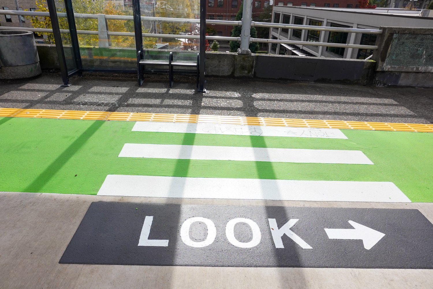
In the eastbound direction, the new bike lane at the bus stop on the viaduct feels like a big upgrade. Similar to designs used on SE Division, the bike lane now goes up and onto a bus island. This allows bus operators to service the stop without pulling in front of bike riders. There are signs and pavement markings urging riders to use caution and watch for people waiting at the station. This isn’t a high speed location for bike riders and there’s a lot of room on the platform, so I think this will work really well.
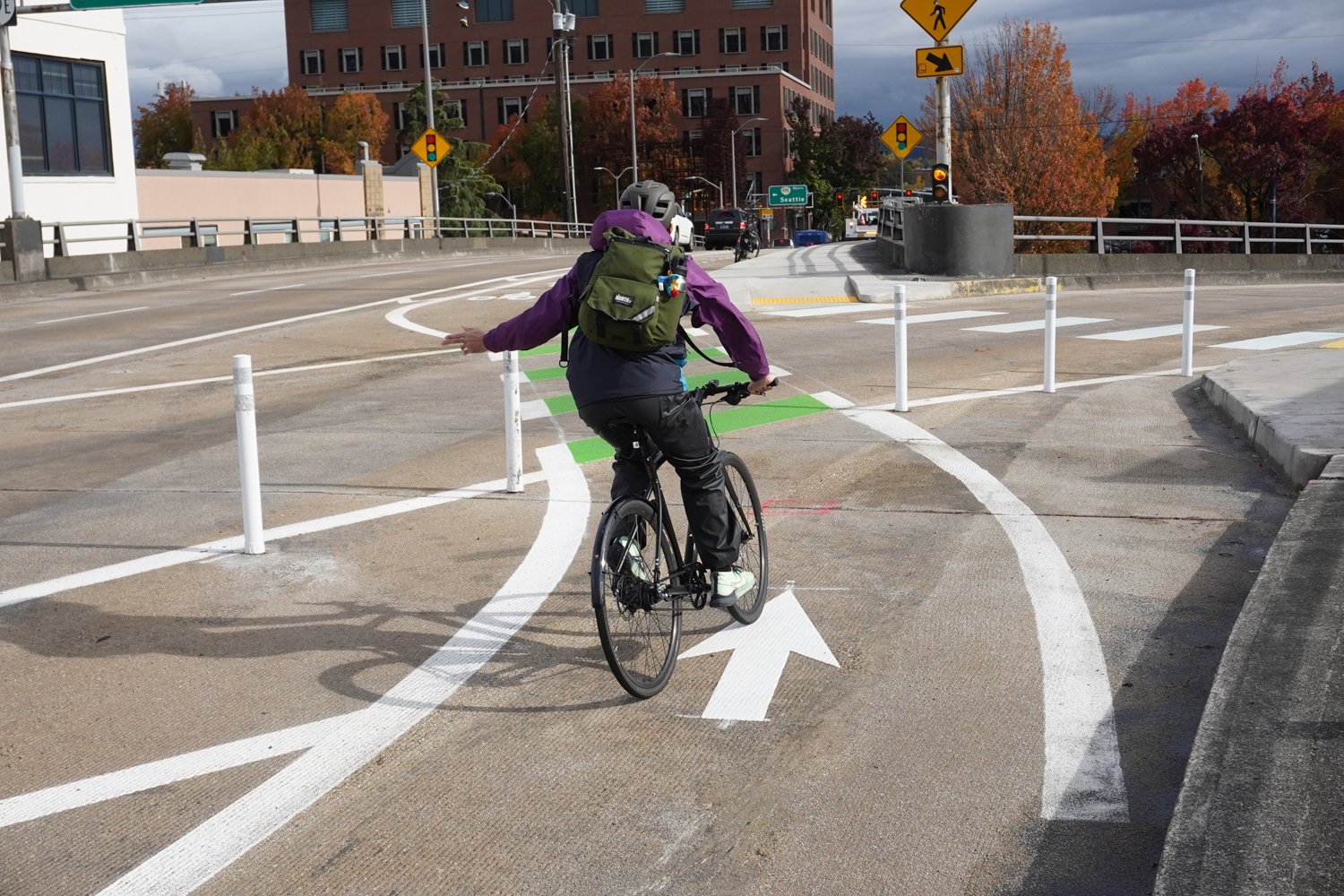
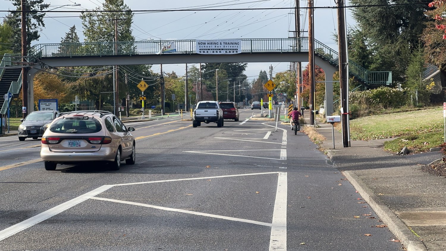
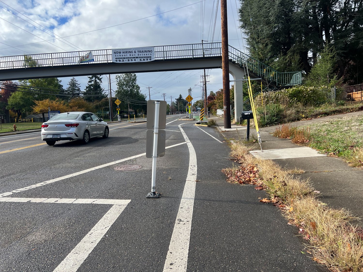
The other change at the SE Clay St. off-ramp is something I’ve already covered. I think everyone realizes the design isn’t perfect and we need a better solution. But at least the county has freshened up the pavement markings and plastic wands and they were willing to change course from a previous design that made it worse.
Have you ridden any of this? I’m curious what other folks think.
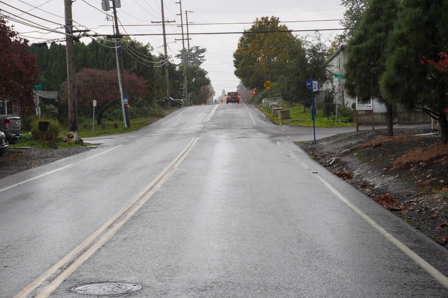
I spent some time on Northeast 105th on Sunday. I wanted to get a better understanding of what might have led to the fatal collision involving a bicycle rider on October 21st. And, like I shared about my time on NE Glisan for the same reason, visiting these locations is important for someone who wants gain deeper perspective and/or write and talk about these tragedies.
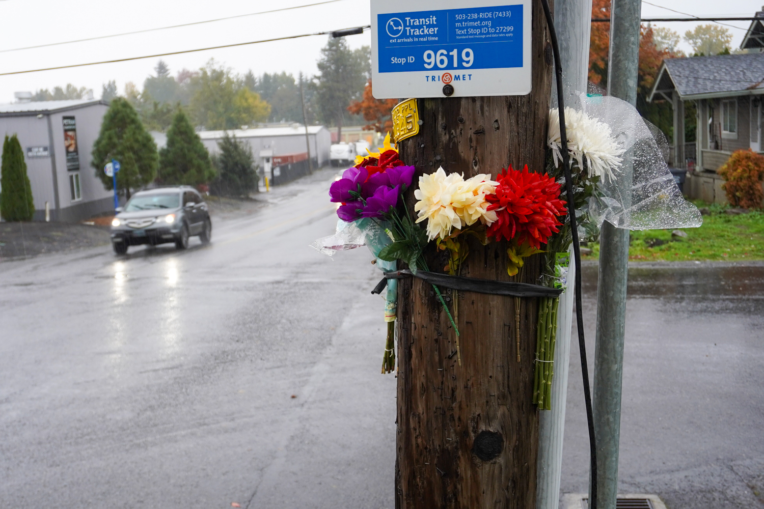
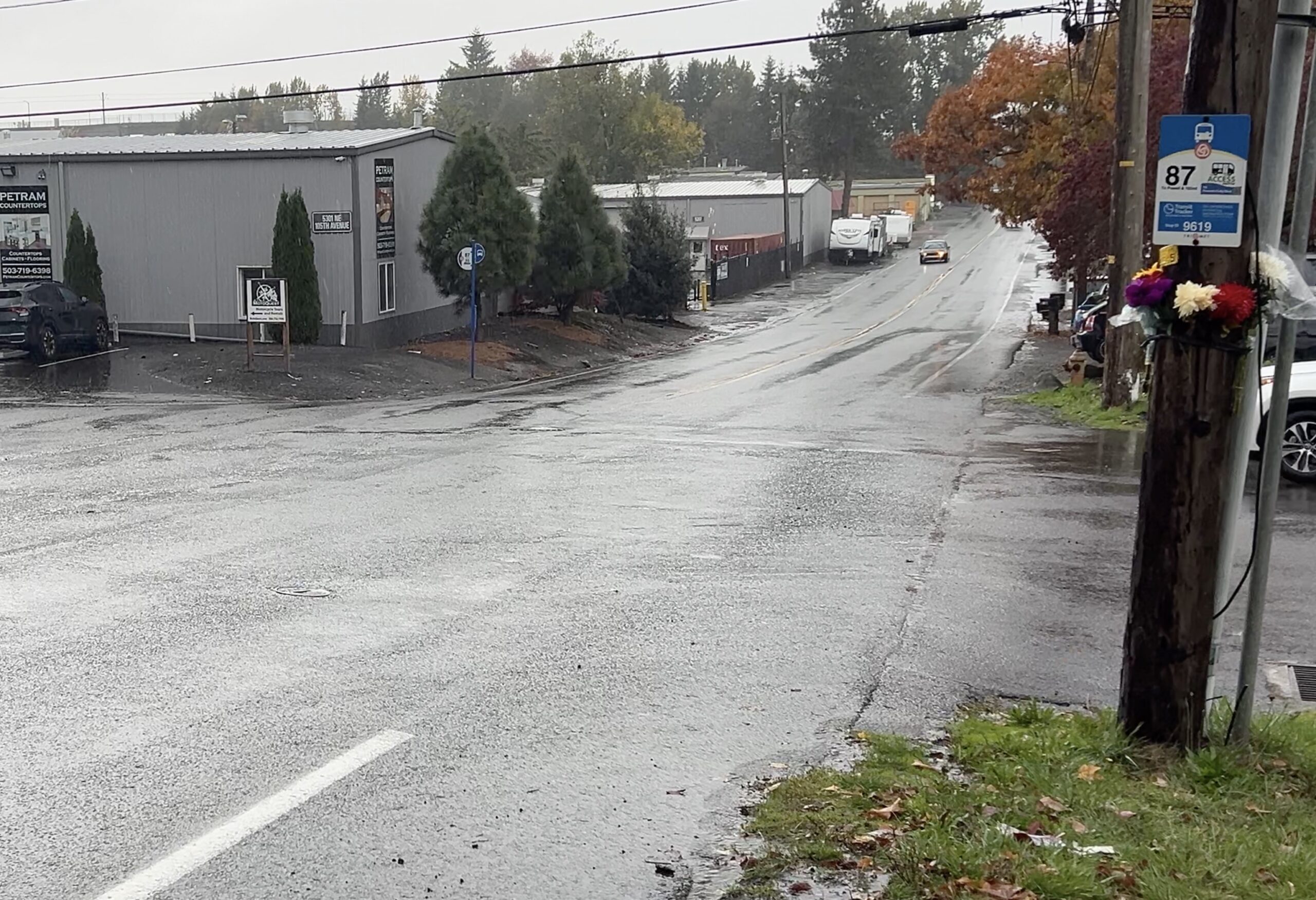
This section of NE 105th at the intersection with NE Marx is where a 32-year-old named Damon (police haven’t released his full name yet) was hit and killed by a driver while he bicycled to work that morning around 9:00 am. According to people who knew him (and have reached out to BikePortland), Damon was a well-loved co-worker worked at a nearby warehouse.
As I’ve reported, police say Damon was riding northbound on 105th and a driver was going south. As Damon crossed NE Marx, for some reason a driver turned left (to go east) and they collided with each other.
The area adjacent to the road is zoned industrial (although there are some houses along it) and is just north of Sandy Blvd and east of the I-205 bike path. NE 105th has a speed limit of 35 mph. There are no dedicated bike lanes or sidewalks. There are two, 12-foot lanes (one in each direction) and a shoulder that varies in width from two to four feet. Sight lines should have been good, but police say the driver was behind other car users so that might have impacted their vision to some degree, depending on how close behind they were. Damon’s vision might also have been impacted by a driver in front of him. I’m not sure about the details yet, so won’t speculate further.
Driver’s view going south on NE 105th. Flowers for the victim at the intersection of NE 105th and Marx.Bike rider’s view going downhill on NE 105th toward Marx.Looking northwest at intersection.
Another notable factor is that the bicycle rider would have been going downhill. There’s about a 2% grade from a railroad crossing near Sandy Blvd toward Marx. On the city’s official bike map, this section of 105th is marked as a “difficult connection.”
I still hope to hear more from the police about how this happened. If anyone has information, please reach out. For another perspective on this location, read this BikePortland comment from Ted Buehler.
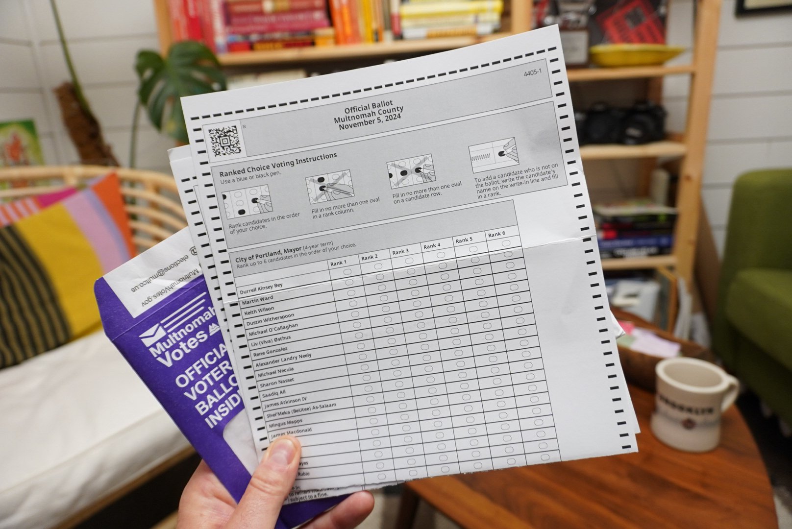
What an election season this has been, huh? Unprecedented in the amount of candidates, the potential for political change, and the scope of the campaigns — I’ve personally never been involved in anything close to this in the past 19 years. With just a few days left before the pencils-down moment of truth, I’ve got a mix of emotions that I’m sure overlap with what many of you are feeling.
Before we transition into talking about who won and why, I wanted to open up a thread to hear your views on local politics, share who you’re voting for, give one last pitch for your favorite candidates, or just share vibes. Whether you’ve voted already or not, I’m curious what BikePortlanders are thinking about this massive — and massively important — local election.
To me, the general political question in Portland right now isn’t whether our electorate has moved to the center or not. That’s settled science. After years of moving to the left that reached a peak during the racial justice and anti-police protests of 2020, I’ve talked to countless people who’ve either told me directly, or signaled in some other way, that they are more centrist in how they see our most pressing issues and the political choices around them.
Beyond private conversations with a variety of people (private because many Portland progressives (a.k.a. liberals, lefties, etc…) fear being called-out or canceled if they don’t appear left-wing enough — a common fear that speaks to a larger problem for progressivism in this city), just look at how the candidates talk on the campaign trail: There are no abolitionist candidates and I don’t think any of them want to be seen as anti-police. Even some progressive standard bearers don’t say, “We shouldn’t have more police.” They say things like, “Let’s fill existing vacancies first,” or, “Let’s make sure we send the right person to the right call.”
The big question is: How many people have moved to the center and how far have they gone?
I know several folks who are classic Portland progressives in many respects, but who’ve voted for candidates that are running on a platform that includes more police, “cleaning up the city” rhetoric, and who’ve been endorsed by Rene Gonzalez (a mayoral candidate so reviled there’s a “Don’t Rank Rene” political action committee).
While clear differences in where candidates fit on the political spectrum are still evident, the lines are not as bright as they would have been in 2020. Portland’s politics have changed significantly.
The big question is: How many people have moved to the center and how far have they gone? I have friends I love and respect who are staunchly in the “Don’t Rank Rene” camp, and others who are voting for him while challenging me to explain why I’m so skeptical. And what’s wild about this election is that, even if you could divine a solid answer to my question above, you wouldn’t have a clear road map of which candidates might benefit from this shift! That’s because many of the leading candidates are difficult to pigeon-hole into traditional left/center/right labels (I’m thinking of folks like Olivia Clarke in District 4, Jesse Cornett and Steve Novick in District 3, and Mariah Hudson in District 2).
For those reasons and others, it is very hard to predict which three candidates will get the nod from each district. I hope we get a healthy mix of political perspectives and lived experiences on council. We need candidates who disagree about key issues like homelessness, public safety, and transportation — because I’ve always believed our best ideas and policies are forged by a healthy debate and openness to “the other side.” Of course, that admittedly idealistic view only works if those 12 councilors — who were backed by different interest groups and bases on different ends of the Portland political spectrum — are willing to work together and make good policy that makes a material difference in our lives.
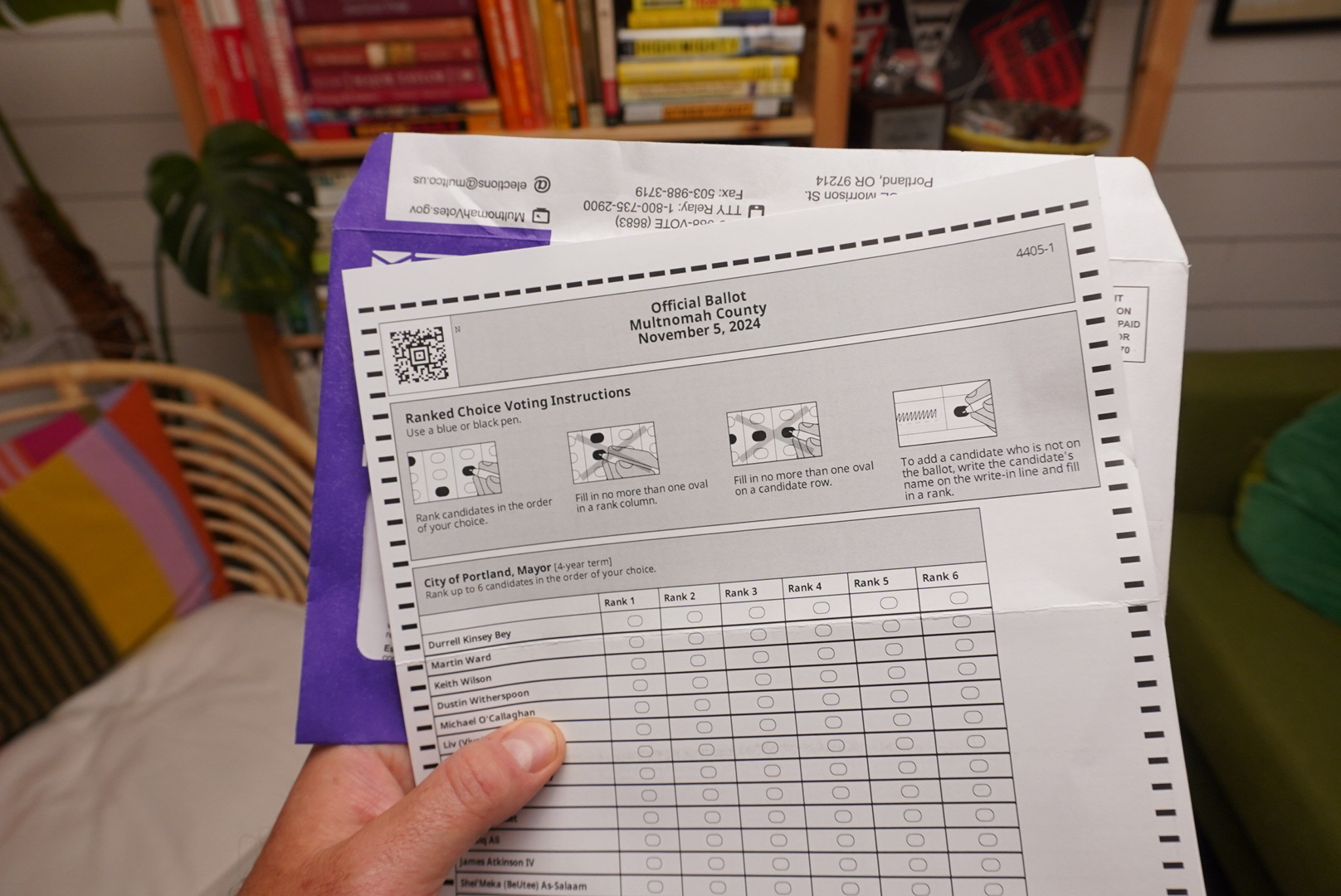
Then there’s mayor. Keith Wilson has a very good shot; but given the new world of ranked-choice voting and the confused mood of Portland voters, it could be anyone among the top three.
What do you think? How are you feeling about our local races? I’d love to hear your predictions, picks, and perspectives.
One last thing… Make sure your ballot is either in the mail and postmarked by Election Day (Tuesday, November 5th), or dropped into an official ballot drop box before 8:00 pm that same day. Find official ballot drop boxes on this Google Map.
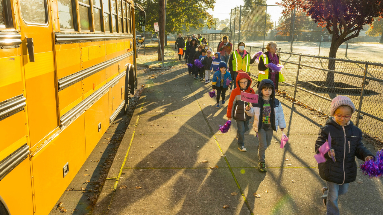
Paid chaperones leading groups of kids on foot might give Big Yellow real competition. (Photo: Oregon Department of Transportation)
If you’re reading these words you’ve almost certainly heard of bike buses — the pedal-powered phenomenon that’s sweeping Portland and the nation. But there’s another version of the bike bus that doesn’t includes bikes. It’s known as a walking school bus. The idea is exactly the same, but instead of bikes swarming the street, kids and parents stick to sidewalks.
They don’t get as much media attention as their bicycling brethren, but walking school buses are about to take off in Portland thanks to a $964,000 grant to nonprofit Oregon Walks from the Portland Clean Energy Fund, which is run by the city’s Bureau of Planning & Sustainability. PCEF raises revenue from a 1% tax on the Portland-based retail sales of large corporations. The Oregon Walks grant will be spread over three years.
I reached out to Oregon Walks to learn more and heard back from Project Manager Sara Etter.
Etter said Oregon Walks identified a need for the students who live close enough to school (within 1-1.5 miles) so they aren’t eligible for a ride on the free yellow school bus, don’t have the option of being driven to school, and live in a place with infrastructure challenges that make walking alone risky.
Those factors, combined with the knowledge that driving emits greenhouse gas emissions, removes an opportunity for physical activity, and contributes to chaotic school drop-off and pick-up lines, made wanting to encourage more walking school buses a no-brainer. “Plus, it’s fun!” added Etter, in an email to BikePortland this week.
So, what will the money be spent on?
“Our grant will fund the widespread deployment of walking school buses across Portland,” Etter explained. “The funds will be used primarily for staffing to organize and manage the program as well as to hire walk leaders/chaperones. Some funding will also go toward the purchase of needed materials for the walks and events, and other costs such as professional development and marketing.”
The idea is that every student who lives inside the busing radius will have a scheduled, adult-supported trip to school they can count on. The vision is to have clearly identified routes, meeting sites, and pickup times. The adult chaperone will walk the route and lead the group while teaching the kids basic walking safety tips along the way. Being able to pay these chaperones is a core tenant of Oregon Walks’ program. “Staffing the chaperones with paid members of the community makes this a professionalized transportation team,” Etter said. It’s also an important equity issue, she added, “Because it signals that student safety and attendance for those students within walking distance of school matters just as much as those students who receive busing services.”
Etter is already setting up partnerships with with housing providers for pickup locations and to encourage participation in the program. The first walking school buses will be on routes in east Portland in areas that have lower quality walking infrastructure and that serve a higher percentage of Black students and other students of color as well as families that have low incomes.
For schools that aren’t lucky enough to partner with Oregon Walks, there’s another avenue to explore. When the Oregon Legislature passed House Bill 3104 in 2023, they authorized school district staff to seek reimbursement from the Oregon Department of Education for expenses related to walking school buses, bike buses, and even crossing guards (after a plan is submitted and approved by ODE). I’ve asked ODE if anyone has taken advantage of that program and will update this post when I hear back.
For Etter and her team, there’s a lot of work already happening to get the first buses up and running: safety and liability protocols, recruitment strategies, bus leader trainings, route planning and so on. She hopes to have the first walking school bus up and running sometime next year.
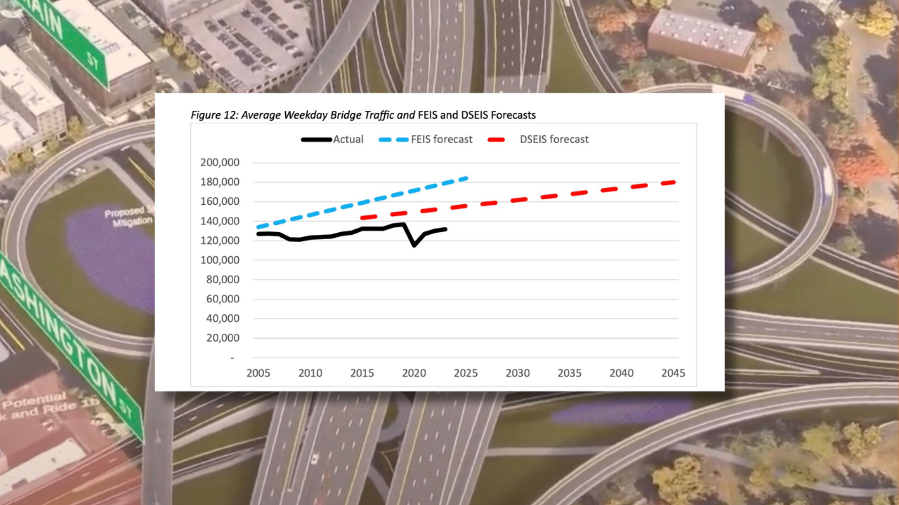
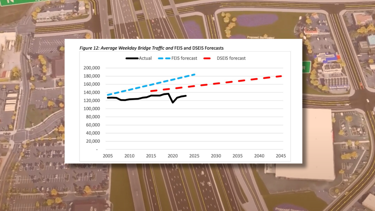
Forecasts from Interstate Bridge Replacement Program versus reality. (Source: Norman Marshall, Smart Mobility Inc.)
With just 18 days left to submit an official comment into the Interstate Bridge Replacement Program (IBRP) Supplemental Draft Environmental Impact Statement (SDEIS), some advocates say they can’t properly assess the project because its leaders are using bad data to analyze the design proposal. Allegations are swirling that transportation department staff and project consultants have “cooked the books” by intentionally manipulating traffic data to justify investing an estimated $7.5 billion on a wider freeway and seven new interchanges across a five-mile stretch of I-5 between Portland and Vancouver.
The IBRP is successor to the Columbia River Crossing (CRC), a project that many thought died in 2014. 10 years later, the megaproject is alive and well with a new name and a new legion of consultants and transportation department staff from Oregon and Washington committed to getting it built. The project has secured $4 billion in federal and state commitments, and while it faces fewer controversies and legal headwinds (so far) than the I-5 Rose Quarter project a few miles south, the IBRP still faces serious questions.
One big problem is that critics and project leaders don’t agree on the same set of basic facts. The ability of people to “meaningfully evaluate” the impacts of a proposed project form the bedrock of the federal National Environmental Policy Act the IBRP is obligated to follow. But experts and outsiders say IBRP staff make it impossible to evaluate the project because the numbers, models, and data being used by project staff are incomplete and/or wrong.
“This is all fantasy numbers,” said Chris Smith, a co-founder of No More Freeways, one of 36 groups in the Just Crossing Alliance coalition that wants to “right size” the project. “How can we meaningfully evaluate the impacts, which is what the EIS [Environmental Impact Statement] is supposed to be about, when it’s all make believe?”
I spoke to Smith a week after Just Crossing Alliance held a press conference to share a 29-page report by an outside consultant that looked at the IBRP’s traffic modeling. Models are used to estimate the future amount of cars, trucks, bikes, and transit users on a given piece of infrastructure. A major concern of advocates tracking the IBRP is that the model that underpins all assumptions about the current proposal is outdated. They say not only is the model bad, but that IBRP officials are manipulating numbers that come from it to suit narratives required to build a more expensive — and expansive — project than needed.
“Garbage in, garbage out.”
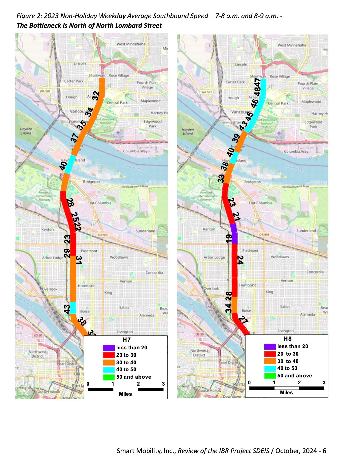
The report, Review of the IBR Project SDEIS, was published by Smart Mobility Inc. President Norman Marshall, an expert with nearly four decades experience in transportation demand modeling who’s completed projects with city governments across the country. Marshall says IBRP is solving for the wrong thing. His examination of traffic data shows the Interstate Bridge is not the bottleneck and that “widening the bridge would do nothing to improve I-5 congestion and could make it worse.”
By analyzing traffic flow and speed patterns, Marshall found congestion in the bridge area actually originates further south at N Lombard during the morning peak and at N Victory Blvd northbound in the afternoon peak. And he says new driving lanes and larger interchanges proposed in the IBRP will encourage more traffic because of induced demand — a proven phenomenon that the SDEIS “almost completely sidesteps” reports a story by The Urbanist this week.
The IBRP SDEIS says the bottleneck originates at the bridge; but Marshall proves in his report that that statement, “is simply wrong.” “The DSEIS fundamentally misrepresents existing northbound [and southbound] traffic conditions in the I-5 corridor,” he writes in the report. “And in doing so, creates an erroneous ‘need’ for the project.”
(Above: Pages from Marshall’s report.)
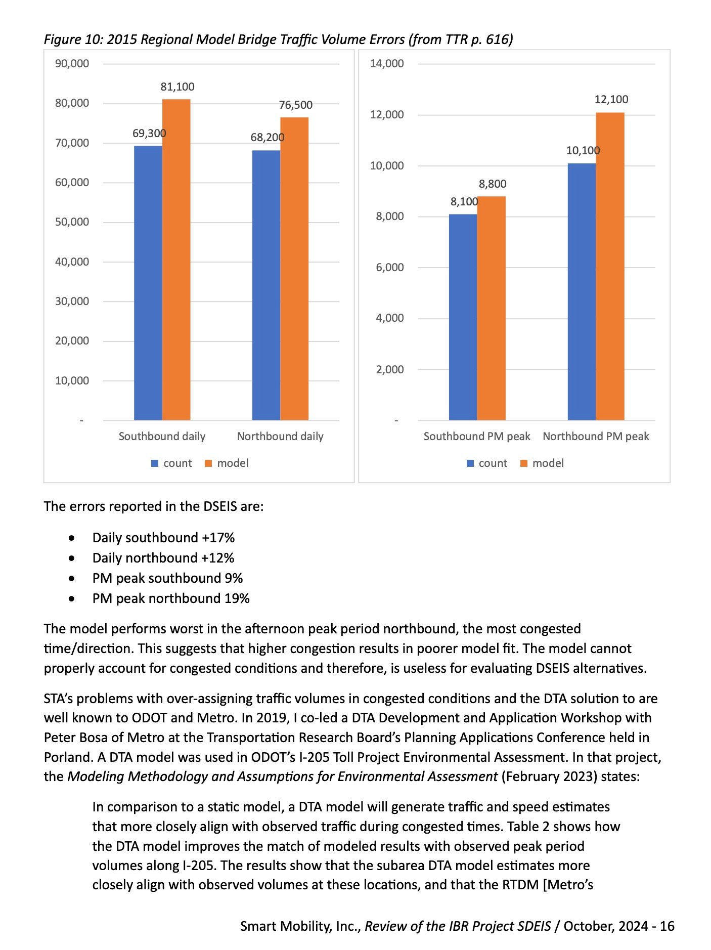
Marshall also blames Metro’s regional travel demand model (which the SDEIS is based on) for using a process that is outdated (it was created in the 1960s) and only considers traffic in a specific area (known as the “static traffic assignment” or STA process), as if traffic volumes within project boundaries are not influenced by traffic volumes outside it. That means known bottlenecks just south of the IBRP project area don’t figure into the analysis of traffic flow within the project area. That’s, “a plainly unrealistic assumption,” Marshall writes in the report.
And here’s why:
“Treating every roadway segment as independent causes the regional model to exaggerate the benefits of widening individual segments because it assumes that traffic throughput can grow on road segments even where traffic growth is prevented by upstream and downstream bottlenecks.”
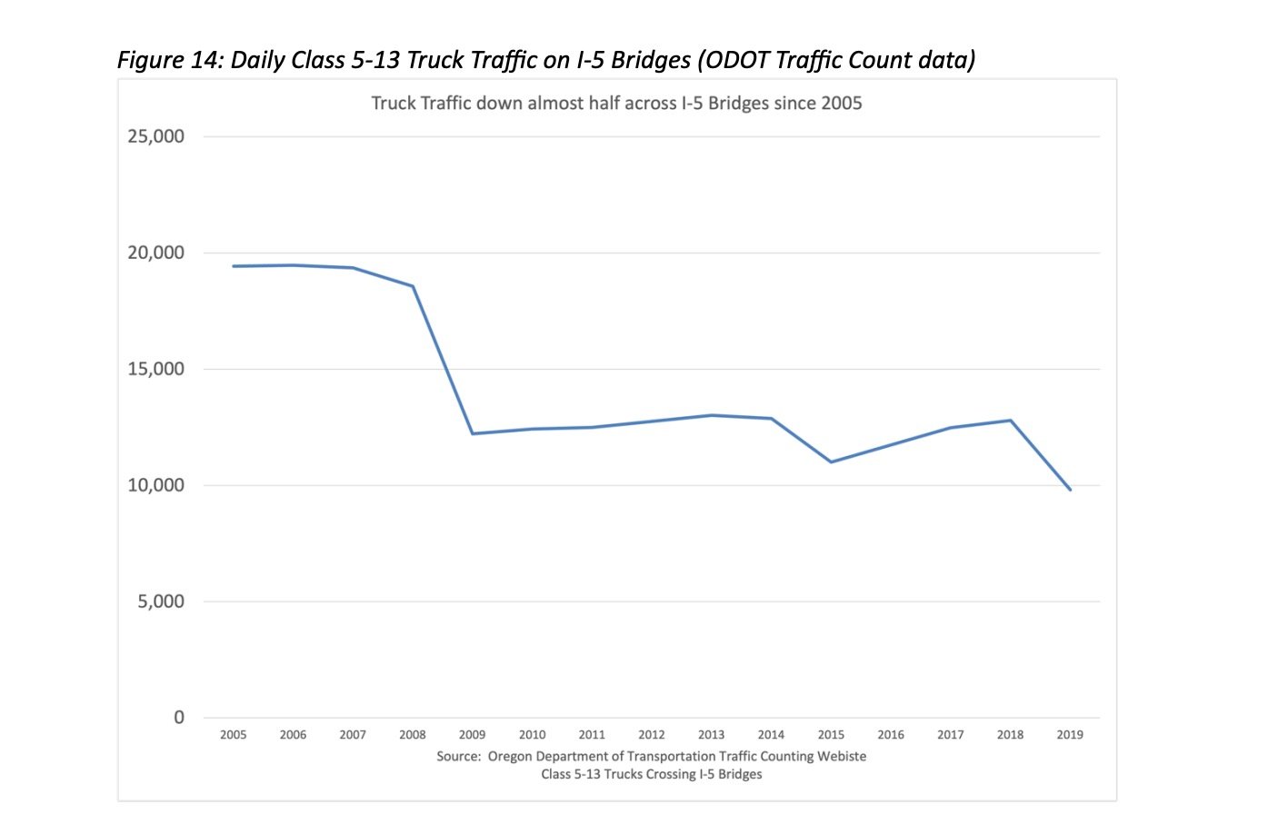
Marshall also claims that the IBRP SDEIS estimates for future traffic growth under the “no-build scenario” are “preposterous” and that there has been no growth in peak hour traffic on this section of I-5 since 2005.
But how can governments justify a $7.5 billion investment without traffic growth numbers to back it up? Economist and freeway expansion skeptic Joe Cortright says the IBRP team “cooked the books” and simply adjusted numbers from Metro’s model to suit their needs. Here’s an excerpt from an article he published this week in City Observatory that claims project leaders (with the help of Metro’s model) “invented millions of phantom trucks to sell a wider bridge”:
“IBR and Metro inflated truck counts to exaggerate the current importance of trucks, and built traffic models that grossly overestimate the growth in truck freight. In essence, these flawed traffic models mean that IBR is widening a freeway to accommodate that truck traffic that doesn’t now exist, and based on false predictions of future truck traffic growth–when in reality truck traffic has been declining.”
Without traffic numbers they can trust, many advocates are scrambling to share impactful feedback during the SDEIS public comment period.
“The air quality and health impacts of this project are directly related to the level of traffic. We need accurate data to confidently assess these impacts,” said Neighbors for Clean Air Co-Director Nakisha Nathan.
Chris Smith echoed that frustration in our conversation earlier this week. “How is any organization like us — that’s trying to really understand the environmental impacts — how are we supposed to do that when there’s nothing in there [the DEIS] we can believe?”
“They tell a wonderful story,” Smith added. “That has no basis in any kind of rigorous analysis.”
— I’ve reached out to the IBRP and hope to share a response or follow-up on these issues soon.
Let’s get wet and wild this weekend! Lots of fun stuff going on to help you shake those I-don’t-feel-like-leaving-my-cozy-house blues.
And before you start planning, consider learning about City Council District 1 (East) candidate Timur Ender. His campaign is sponsoring this message so you know he’s legit if they are smart enough to buy ads on BikePortland.
Saturday, November 2nd
Springwater Path Clean-Up – 9:00 am at Springwater Cart Park (SE) Join SOLVE to help pick up trash and beautify our beloved Springwater path. When you’re done, enjoy great food from the carts. More info here.
Dig Day at Sandy Ridge – 9:00 am at Sandy Ridge Trailhead (Sandy) Earn your turns and deposit some sweat equity into your riding account by helping NW Trail Alliance maintain these wonderful trails. More info here.
Celebrate the Rain – 10:00 am at PCC CLIMB Center (SE) Join our friends at PBOT for a bike ride that embraces the liquid sunshine and will offer you tips and inspiration from experienced riders. Expect an 11-mile loop at an easy pace. And of course it’s rain or shine. More info here.
International Single Speed Day – 10:00 am at Portland Fire & Rescue Dock 21 (Esplanade) One gear isn’t just simpler, it’s better. At least that’s what devotees of the “single speed lifestyle” believe. Roll out and discover what one gear can do for you. More info here.
Ride to Cyclist Memorials – 10:00 am at Wilshire Park (NE) Ted and Gil will lead a ride out to the Bike Loud PDX and Families for Safe Streets vigils and rallies in northeast to remember two people killed on October 21st. First stop is NE Marx and 105th. More info here.
Dia de los Muertos Altar Tour – 1:00 pm at Milagro (SE) Milagro theater and The Street Trust will lead you to eight Dia de los Muertos altars in the Central Eastside district. More info here.
Sunday, November 3rd
Cyclocross Crusade #6 – All Day at McMenamins Edgefield (Troutdale) The beautiful grounds of Edgefield will take your breath away (literally) at the penultimate stop of the series. Expect climbs and cambered turns through orchards and great beer and food awaiting you at the finish line! More info here.
Nomad Cycles Monthly E-Bike Ride – 2:00 pm at Portland Saturday Market (SW) Join Brad and his merry band of battery-powered bicycling buddies at the market and then ride together up into Washington Park. It’ll be gorgeous up there this time of year! Don’t forget to charge your batteries. More info here.
— Did I miss your event? Please let me know by filling out our contact form, or just email me at maus.jonathan@gmail.com.
I have always made an effort to visit places where people have been killed while using Portland roads. It changes me to be in the same place where stuff like this has happened. It’s radicalizing, illuminating, sobering, often terrifying, and usually, extremely frustrating. Frustrating because I’ve done this dozens of times over the years, and each time it just seems like such a senseless waste of human potential and something that we could have prevented. Whenever I hear from family or friends of victims, the one thing I always share is “I’m sorry.” And I say that not just in the traditional, general sense of empathy for their loss, but “sorry” because I feel like we all have a roll in making our streets safe and when we don’t do enough, a death can be the outcome.
As I sat in the passenger seat of our car Saturday with my phone balanced on the dashboard to get video of NE Glisan (I wanted the driver’s perspective too) where it passes Menlo Park Elementary School, I could feel myself getting angry. All last week I was in touch with a nearby resident who shared videos of people driving into medians and sign poles on this same section of road. But it was the video of a sports car driver flying west on Glisan near the pedestrian overpass outside the school that made me mad. Actually, it was the seconds before that car zoomed across my screen. The seconds that showed someone on a bike, leisurely riding with no hands in the middle of the lane (not the bike lane). I’ve done that myself so many times. When I was a kid I’d ride home late from my girlfriend’s house. I lived in a quiet Orange County, California suburb and the massive stroads in my neighborhood were barely occupied late at night. I would ride in the middle of the street as fast as I could, trying to beat my record home. With noise from wind in my ears, especially if it was raining or stormy, I could imagine not hearing a fast driver coming up behind me.
All I could think of while at the site Saturday was that video. The sound of the car and its impact. The finality of what happened. Just because one selfish person decided they mattered more than everyone else for those few fateful minutes.
The sight lines are perfect at this location. The driver going westbound on Glisan toward 128th (and the pedestrian overpass) would have had nothing obstructing their view in front of them. I will not speculate further about what might have happened until I can verify details.
Various views of westbound NE Glisan where a man was killed by a driver while bicycling on 10/21/24.
I’ll speak to what I saw on Saturday: concrete median islands clearly damaged from reckless drivers and many plastic posts either damaged or completely uprooted. Glisan has parking-protected bike lanes in this location. That means PBOT puts a bike lane curbside and floats car parking spaces in the street. Ostensibly these parked cars provide a protective buffer between drivers and bike riders. PBOT likes the design because it’s cheap (parked cars usually take the place of permanent concrete) and it doesn’t upset the apple cart as much as removing parking spaces does. One problem with this approach however, is that when there are no cars present, we’re left with a wide road and bike riders that are totally unprotected. The only thing “protecting” someone using the bike lane are a few parking sign posts on floppy springs, maybe plastic delineator wands (if they haven’t already been uprooted by errant drivers), and stripes of paint.
Curbside bike lanes are also more likely to be obstructed, since debris accumulates in them and PBOT still doesn’t reliably keep these spaces clean. I have no idea why the victim in this collision was riding in the general travel lane instead of the bike lane. They might have been prepping to take a left and go south on the neighborhood greenway a block away on NE 128th. Or they might have felt like the bike lane was too narrow and obstructed. Looking west at the point of impact, the bike lane narrows due to a sign pole, then it’s obstructed by a storm drain grate, then curves to go around a planted bioswale and then makes another curve into the protected crossing and bike lane in front of Menlo Park school.
Not sure what else to say about this location. Usually fatal crashes happen at intersections and there’s a turning movement involved. Collisions like this where someone just rams into another person from behind, are very rare.
I am still waiting to hear from police about the identity of the rider and get an update on the hit-and-run investigation. Stay tuned.
If you’d like to take part in a vigil for this rider, and for the person killed while biking just three miles away, there’s a vigil planned for this Saturday. It’s being organized by Bike Loud and Families for Safe Streets. They’ll meet at NE Marx and 105th (I have a post and video about that coming soon) at 11:30 am for a moment of silence and then ride to NE Glisan and 128th for a vigil and call to action. More event details here.
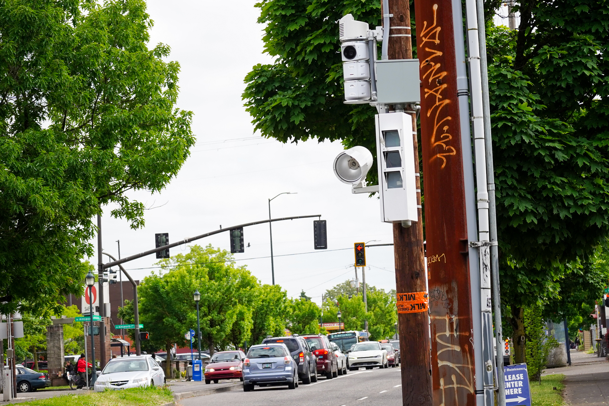
PBOT speed camera on Martin Luther King Jr Blvd just north of Ainsworth. (Photo: Jonathan Maus/BikePortland)
As our community grasps for solutions to our ongoing crisis of traffic crashes and fatalities, the City of Portland has launched a survey to gauge our mood about automated enforcement cameras.
In a statement today, the Portland Bureau of Transportation says they’ve teamed up with the Portland Police Bureau to ask all Portlanders how they feel about enforcement cameras and road safety in general. “Feedback from the survey will help the city better meet community needs and expectations,” they say.
Portland began its camera program in 2016, following the passage of a state law in 2015 that authorized their use for the first time ever. It took four years to get just four locations equipped with them and and the delays frustrated many advocates. One problem was a bottleneck at the PPB, since each citation (and there were around 42,000 of them per year in the first few years) had to be verified by a sworn officer. That bottleneck was fixed in 2022 when Oregon lawmakers passed a bill allowing non-police to review and process citations. Another source of delay was the camera vendors, who former PBOT Commissioner Jo Ann Hardesty once threatened to fire because of it.
Today it seems like PBOT has ironed out the wrinkles and there are now 28 cameras actively issuing citations (with two under repair) and another 10 coming online soon. The city deploys two types of cameras: one just for speeding and the other, “intersection safety cameras,” that can also cite for red light running.
I haven’t heard what prompted this latest survey, but based on city documents about the program, PBOT does a survey once per year just to monitor public perception. This will also give the agency fresh information to indoctrinate a new slate of City Council candidates and a new mayor next year.
They survey asks a range of questions about the cameras. It also queries respondents about the role of speeding in traffic crashes, whether or not the city is doing enough enforcement of traffic laws in general, and more.
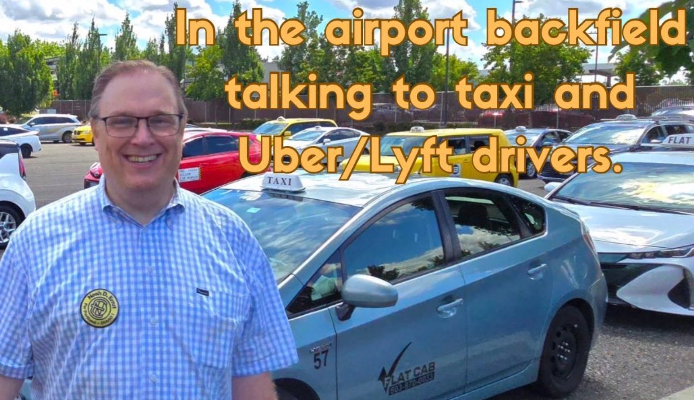
I’ve been tracking City Council District 1 candidate Noah Ernst since this past spring — ever since he started posting about transportation on his Instagram account. Now that Ernst has picked up an endorsement from The Oregonian and was just in the news for being hit by a drunk driver while operating his cab on Sunday, I figure it’s a good time to share a bit more about him.
According to a story by KGW and Ernst himself, he was on SW 15th crossing northbound onto W Burnside when someone plowed into him. Luckily it was relatively low speed and Ernst wasn’t seriously injured. The other driver was cited for driving under the influence.
It’s notable that Ernst was involved in a traffic collision because he’s by far the most outspoken critic of Portland’s approach to traffic safety among the 100 or so candidates running for City Council. “I don’t know if it’s ironic,” Ernst told KGW. “It’s certainly incredibly frustrating, but at the same time, at least, I can use myself as an example to say, ‘Look how badly things are going. Look how we need to make changes we need to make the city of Portland and better place a safer place’.”
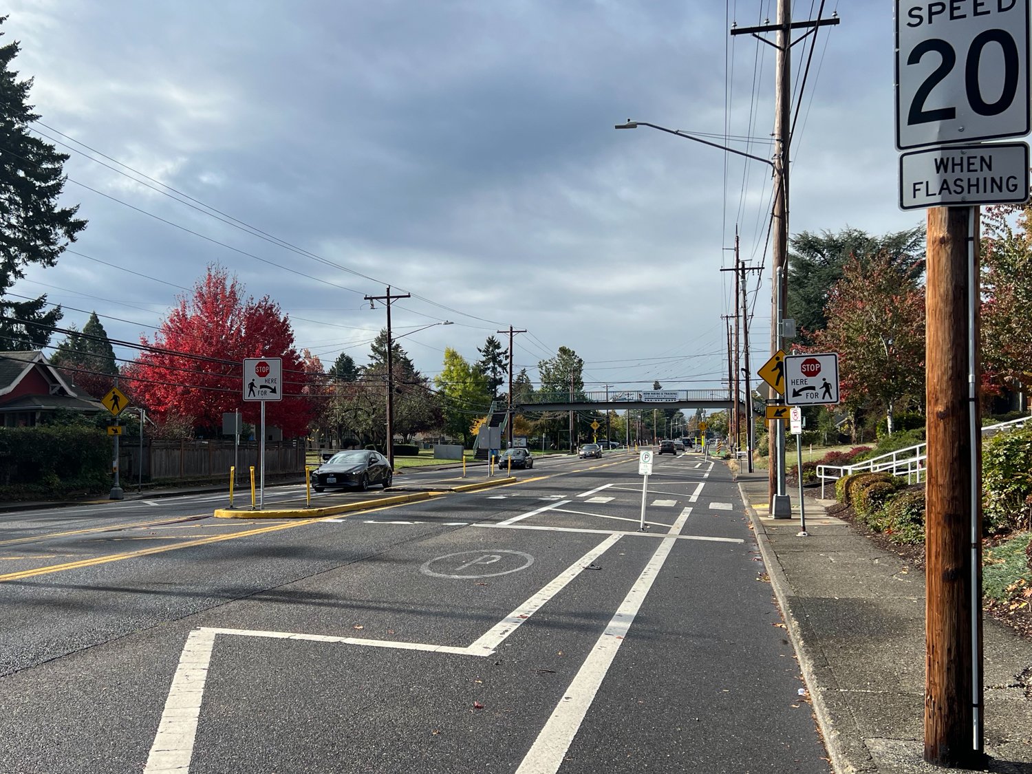
I don’t know the details of how the collision happened, but Ernst might take solace in the fact that the Portland Bureau of Transportation just lowered the speed limit on W Burnside to 20 mph in the segment where he was hit (between 2nd and 24th). I know a lot of people dismiss speed limit decreases without enforcement; but making a marquee street like Burnside the same maximum speed as a residential neighborhood street is a pretty big deal!
I think we need more critics like Ernst in order to have a healthy debate about our approaches to difficult problems like how to tame east Portland arterials and eliminate the fatal crashes that plague them. I also think it’s interesting Ernst believes the solution to safer streets and preventing crashes like the one he was in, is to make driving easier and to encourage more of it.
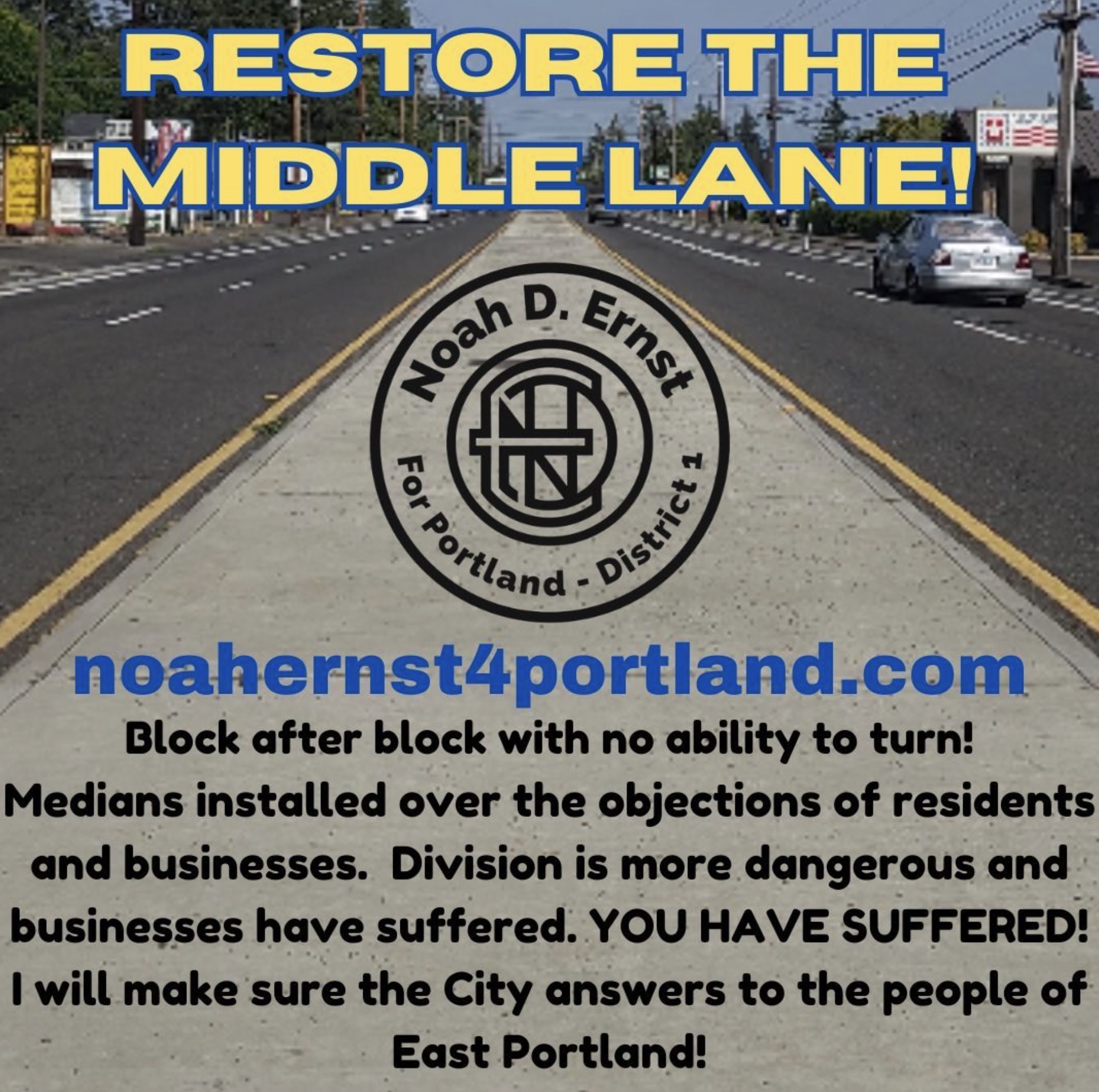
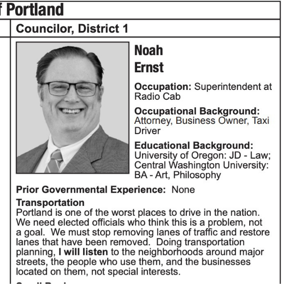
Ernst Instagram posts (left and right) and a snip from his voter pamphlet statement (center).
He wants to remove the center median recently installed on SE Division because he alleges it has made the street more dangerous and has hurt businesses. He says PBOT road designs have caused too much congestion for drivers and laments that Portland is ranked one of the “10 worst cities to drive in.” Ernst doesn’t use “war on cars” rhetoric like one of his competitors in District 1, Terrence Hayes, but he clearly believes PBOT’s approach is too hard on car users.
On a recent episode of the NW Fresh Podcast, Ernst responded to a statement from the host that too many decisions in Portland cater to a, “very small, vocal, loud segment” of the population. “My favorite example of that,” Ernst eagerly replied. “Is there is a bicycle committee that advises PBOT on literally every transportation plan that they introduce… And bicyclists make up less than 5% of the commuters. But 80 plus percent of the commuters on a daily basis are in cars — yet they have no input at all in any way on a committee level or anything else in transportation policy that’s being adopted by PBOT.”
Ernst is a former cab driver and now works as legal counsel for a cab company, so it’s easy to see where some of his interests lie. But it should be said that he either doesn’t understand how PBOT and their advisory committees work and/or he’s willfully misleading District 1 voters to make a political point.
PBOT has three transportation advisory committees: bicycling, pedestrian and freight. I’ve attended all three of them many times over the past two decades (especially the bicycling one, which I rarely miss). One of the chief complaints of the bike committee is that it has almost no influence over PBOT, much less any influence in City Hall. The freight committee is the one that really throws its weight around. Unlike the other two committees whose members are unpaid individuals, freight committee members are mostly professionals from freight-related businesses or advocacy groups who are being paid to attend the meetings (it’s chaired by Oregon Trucking Association President Jana Jarvis, arguably the most influential transportation advocate in the state).
And while Portland doesn’t have a Driving Advisory Committee, the freight committee does a great job advocating for pro-driving policies. They are staunchly supportive of wider driving lanes and regularly advocate for pushing bicycle users off main roads and onto side streets. That’s the same position Ernst likes to take. And for what it’s worth, the vast majority of bicycle committee members are also drivers (the idea that Portlanders can be divided up into mode labels is convenient for political stump speeches, but has no basis in reality). It’s also a fact that PBOT planners and engineers have a “design vehicle” for every project they build — a vehicle they consider when determining routes, turning radii, lane widths, and so on. Their design vehicle for road projects is an Ford F150 truck.
On the east Portland arterials where we suffer the majority of our fatal crashes — including four this past week alone — Ernst wants driving to be easier and faster. “What PBOT refers to as ‘high crash corridors’ are simply the main arteries that most of us use on a daily basis to get around Portland,” Ernst has said on the campaign trail. “While PBOT attempts to characterize those streets as especially dangerous, the truth is (all things being equal) we would expect that 74% of accidents would occur where 74% of the traffic is. These streets are not necessarily especially dangerous, they are just especially busy. For good reason. They are the most efficient routes.”
Ernst believes it’s possible to improve conditions for drivers and still make roads safer for everyone. He says we’d save lives by cracking down on impaired and speeding drivers during late night hours. “Impeding the smooth and efficient flow of traffic on main thoroughfares during our daily commutes won’t address that problem. Increased traffic enforcement during those hours will,” he writes.
In the voter pamphlet, the statement from Ernst reads: “Portland is one of the worst places to drive in the nation. We need elected officials who think this is a problem, not a goal. We must stop removing lanes of traffic and restore lanes that have been removed.”
I appreciate that Ernst is thinking and speaking about these issues. Unfortunately, his positions on transportation are clouded by his profession and his own preference for driving. It’s wishful to think Portland can provide free-flowing traffic for everyone who wants to drive and simultaneously grow the number of people who choose not to. And thinking we can simply shift the responsibility for safe driving onto the shoulders of police and enforcement is a nice idea; but the reality is our street designs must carry most of the enforcement load.
And promoting the idea that there’s some cabal of bike activists nefariously pulling strings at PBOT and City Hall undermines the good work of a lot of volunteers dedicated to safer streets. And it simply doesn’t match reality.
One final word about Ernst’s comment on PBOT advisory committees: I’ve said many times over the years that I wish we had a Driving Advisory Committee or some sort of driving advocacy group because it would enrich the debate and remove the ability of people like Ernst to imply drivers’ perspectives aren’t being heard. I also think it would allow us to fully air out these debates and I believe we arrive at better outcomes when we embrace healthy discussions among people who disagree — instead of trying to shut them down.
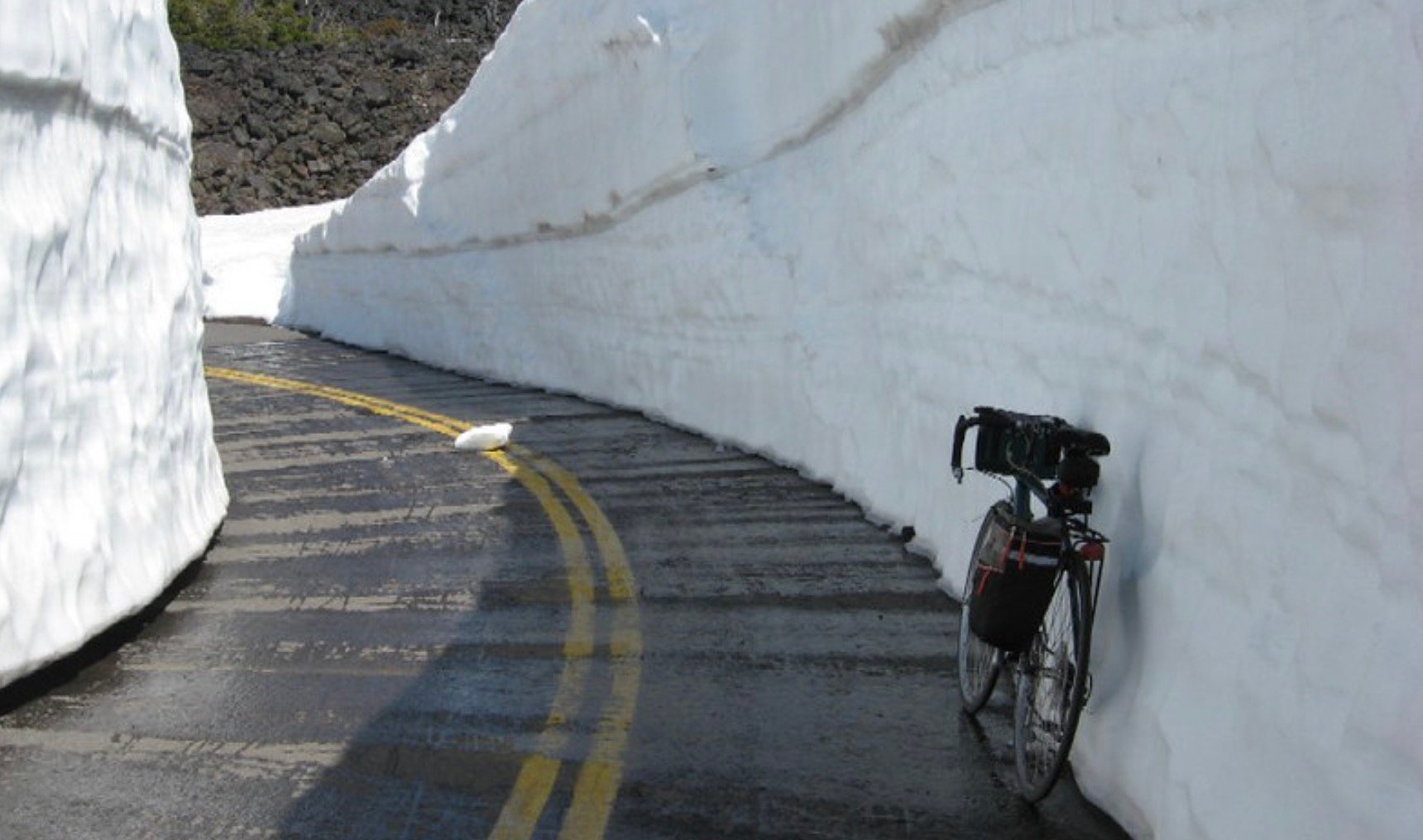
Bike riding through snow on McKenzie Pass Hwy. (2011 Photo by Oregon Department of Transportation).
The State of Oregon has rolled up their welcome mat when it comes to cycling on McKenzie Pass during it’s annual winter closure.
In the past, the closure of this epic highway (OR 242) that’s considered to be one of the best rides in Oregon, was considered an open invitation to bicycle riders to enjoy it carfree. The closure is done each year by the Oregon Department of Transportation at the start of the winter storm season in order to save maintenance costs (it’s considered a secondary highway, so isn’t essential for travel). As word has spread, a growing number of riders seize the opportunity each year in late spring as snow melts. They ride up and over the pass thanks to ODOT crews who plow a narrow path through the massive snowfall — and it all happens before the “road closed” gates open back up for drivers.
But according to the Salem Statesman Journal, ODOT wants to tamp down on this cycling tradition. “Over the past few years, the Oregon Department of Transportation quietly decided that once the highway is closed to cars, it’s closed to everyone else as well,” reads a story published Sunday. The story also says ODOT has liability concerns and is partly motivated by an allegedly large number of close calls between bike riders and maintenance crews during a paving project this past summer.
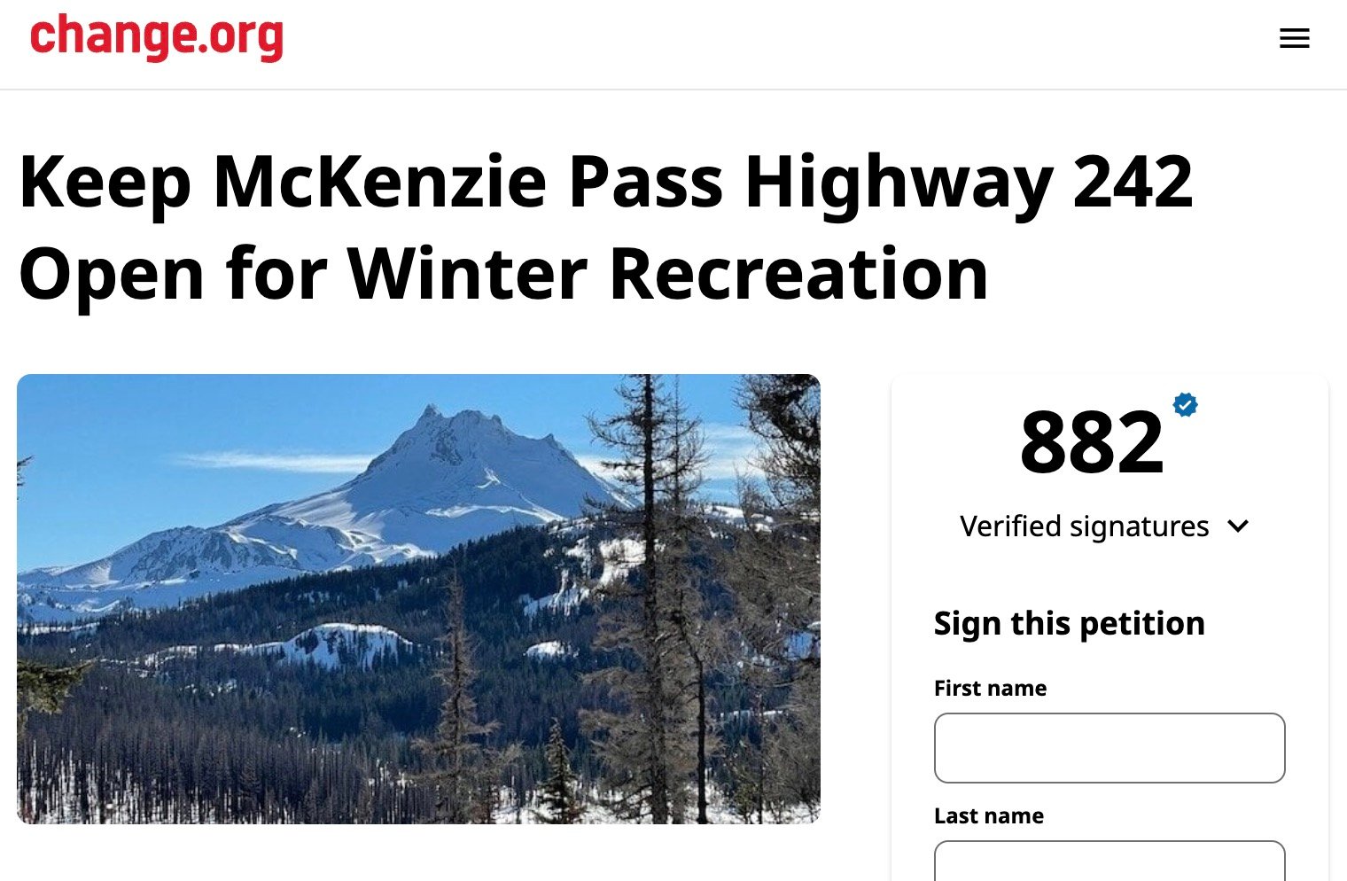
Now cycling and snowmobiling groups in nearby Sisters, Oregon are shocked and they’ve mounted a campaign to encourage ODOT to reconsider. A Change.org petition to, “Keep McKenzie Pass Highway 242 open for winter recreation,” has gathered nearly 900 signatures in just two days.
When I saw the Statesman Journal article, it struck a nerve. Back in March I found myself on the McKenzie Pass website and noticed language about how the road was “closed to everyone.” That seemed like a big change from when ODOT promoted the route as a carfree cycling opportunity, so I emailed ODOT Region 4 Public Information Officer Kacey Davey and asked to explain whether or not the policy had changed.
“There has been no policy change, as there was never a policy saying that the road was open to just bikes. It was public perception,” Davey shared in an email last spring. “In recent years we have been stronger about our language letting folks know that closed areas are closed to everyone,” she added.
But ODOT is partly to blame for that perception. In 2019, their press release announcing the closure stated, “This is the annual closure of the highway to motorized vehicles… Non-motorized users, including hikers and bicyclists, access the area at their own risk when it is closed to motorized vehicles.” And in 2018, ODOT officials made it clear they expected bicycle riders on the highway. After a fire damaged the highway and crews were on hand to make repairs, an ODOT press release said warning signs about the project would be removed on weekends (emphasis mine), “to indicate that visiting is permitted. However visitors, including cyclists and pedestrians,” read the statement, “must be aware that ODOT is not maintaining the highway for wheeled travel at this time…”
It’s easy to see why folks are confused about the shift in tone around the closure. ODOT won’t communicate an outright cycling ban because they don’t have the enforcement capabilities to back it up. So for now, they’re strongly encouraging folks to not ride during the winter closure and making it clear that anyone who goes past the gates is, “doing so at their own risk.”
The tougher-on-drivers enforcement many have been clamoring for is taking a step forward.
The Portland Bureau of Transportation just announced that their parking enforcement squad will now “order an automatic tow for any vehicle that does not have a visible vehicle identification number (VIN) and does not display at least one license plate.” This type of enforcement is key to combatting the creeping sense of lawlessness and “anything goes” mentality among a growing number of drivers.
In a statement today, PBOT said recent changes in city code give them the authority to take this step. It comes about four months after PBOT announced the hiring of 22 new parking enforcement officers and made a notable change in tone in how they talk about enforcing these kind of laws. The move is also likely related to the growing problem of abandoned RVs and other vehicles that clog and clutter the public right-of-way. “Allowing for an automatic tow will help parking enforcement officers more quickly clear vehicles in violation of city code from the public right-of-way – including abandoned autos,” reads the PBOT statement.
Being able to track vehicles to a specific owner in the case a crime was committed and making sure folks have visible license plates for enforcement cameras and other identification reasons, is a big part of making our streets safer. In addition to these and right-of-way issues mentioned by PBOT, this move also gets at a very necessary change in driving culture many folks who care about road safety have been talking about for years.
Culture change is hard and some folks think it’s not a battle worth fighting. But I disagree! Driving and owning a car is an immense responsibility and doing it wrong can have deadly consequences. The increase in drivers who cover their plates and/or don’t have a plate at all is a very troubling trend. There’s a growing sense that we need to see cars as deadly weapons and regulate them as such. Getting tougher on towing is a step in that direction.
If you see an illegally parked car, truck or other type of vehicle in the public right-of-way, you can report it to the Parking Enforcement Division by calling 503-823-5195 on Monday to Friday from 6:15 a.m. to 11:15 p.m., Saturday from 8:15 a.m. to 11:15 p.m., and Sunday from 8:45 a.m. to 11:15 p.m. All other times, contact Police non-emergency at 503-823-3333.
After a man was killed by a driver while bicycling on Northeast Glisan one week ago, I heard from a nearby resident who wasn’t shocked at all. Why? Because he’s seen dozens of speeding, dangerous drivers over the course of the past few years wreaking havoc on the street outside his door.
“People drive reckless on this section,” the resident (who has asked to remain anonymous) told me. “They use the bike lanes and center lane as passing lanes. Driver’s regularly do 60-plus mph.” And in dozens of videos clips taken by home security cameras and shared with BikePortland, many of these drivers slam into concrete medians, metal sign poles, and other infrastructure — all of it installed to make the street safer.
In the video above you can see — and hear — some examples. Drivers hit the concrete medians between 128th and 130th at full speed, sometimes launching into the air. You hear the breaking of metal, the “crunch” of impact, then see the damage to cars and the infrastructure we all pay for. The clips I share are a selection of what he sent me, and there are many more he hasn’t sent. About two years ago, he estimated there used to be about three crashes a week. Now he sees damaged infrastructure and/or captures a collision on video about once every 10 days.
Damaged median in front of Menlo Park Elementary on NE Glisan.Damaged median in front of Menlo Park Elementary on NE Glisan.Flowers for an unknown victim.(Photos: Jonathan Maus/BikePortland)
The one video I’m not sharing yet clearly shows a driver speeding westbound on Glisan and striking a man on a bicycle from behind. In one angle, I watched a man riding with no hands, looking like he had no care in the world while he enjoyed a late night ride. Then, in a flash, a blur flies across the screen. It’s a driver going at least twice as fast as other drivers on the road and headed directly for the rider. Then the unforgettable, gut-knotting sound of impact.
Looking west on NE Glisan toward 128th. The median on the left is the one several cars in the video hit (out of frame).
Glisan a ‘High Crash’ Location
This section of NE Glisan is on the City of Portland’s list of “high crash corridors” streets that have an above average rate of serious crashes, injuries, and deaths. As such, the Glisan gets priority for safety investments and more scrutiny from transportation bureau officials.
Reached for comment on this story, Portland Bureau of Transportation Public Information Officer Dylan Rivera said PBOT has already made some “safety improvements” on Glisan and has more on the way.
“The observation of crashes at a place where we have a public school entrance, a pedestrian bridge, a marked school crossing with a flashing beacon, crosswalk and cross-bike and bike lane protected by concrete curbs indicate the need to address education and enforcement, as well as engineering as we work to make our streets safer,” Rivera shared with BikePortland.
Rivera said they’re “eager” to install more automated enforcement cameras and that PBOT will consider more location on Glisan in addition to ones installed 2.5 miles away at 82nd Avenue. A forthcoming $20 million investment into 122nd Avenue will include major upgrades to the NE Glisan intersection about 10 blocks away.
But what about this particular spot?
I asked Rivera how often PBOT maintenance crews have had to come out and replace broken signs, poles and other infrastructure in the blocks near NE 128th and 130th. Here’s the list he sent back:
3/1/2022 – Replaced 9 delineators at the intersection of 122nd and Glisan
8/4/2022 – Replaced 1 delineator just east 122nd on Glisan
3/29/2023 – Replaced 19 delineators on the islands and curb bike buffer at 128th and Glisan
1/10/24 – Replaced missing delineators on the island at 128th and Glisan
7/11/22 – Replaced down pipe and sign at 132nd and Glisan
3/29/23 – Replaced missing pipe and signs at 130th and Glisan
1/24/2024 – Replaced downed signs on median on the island at 128th and Glisan
3/27/2024 – Replaced missing pipe and sign on the island at 129th and Glisan
4/5/2024 – Reinstalled pipe and sign in Bio Swell 126th and Glisan
7/30/2024 – Replaced missing sign at the median on 130th and Glisan
10/14/2024 – Reinstalled downed pipe and sign at 133rd and Glisan
I could see some of the damage during a visit to the site over the weekend. Large chunks of curb are missing. Plastic delineator posts are battered and/or missing.
If this is what happens after PBOT does a major safety intervention, what are we doing wrong?
The resident who shared videos with me says one big factor is that local drivers don’t respect the bike lanes because they rarely see people riding in them (a situation I’ve been concerned about for years as well). He’s also concerned that staff at Menlo Park Elementary School do nothing to build that respect when they allow parents in cars to use the protected bike lanes outside the school to drop-off and pick-up their kids.
I hope people realize the design issue is there’s not enough concrete. The median crossings are relatively robust compared to the anemic protected bike lanes which rely only on paint. That leaves the existing medians floating on islands in the middle of a relatively wide and fast arterial. If we added more concrete to define the bike lanes we’d have better protection for riders and we’d give drivers more visual cues to slow down and it’d be less likely they’d strike the islands.
Rivera at PBOT hinted that the city knows the infrastructure on Glisan isn’t as robust as it needs to be. He said they felt pressured by, “public interest in moving quickly to improve traffic safety, especially to create protected bike lanes using inexpensive, temporary materials, as a way to deliver timely improvements.” So Glisan, Rivera explained, is a location where they “moved quickly and used plastic materials to provide protection.”
But these video clips, Monday’s horrible fatal collision — and the three other deaths on east Portland roads since — should make it clear that PBOT’s quick-and-cheap bike lane approach is just one reason this is happening. It feels like this is yet another illustration of the epidemic of lawless, inattentive driving that plagues our city — and the lack of enforcement that goes along with it.
It also shows that PBOT’s incremental, under-designed, under-funded Vision Zero projects are simply not enough to meet the threat of today’s drivers. I had a bad feeling about this when elected officials and PBOT staff held a press conference in 2018 just 1.5 miles away on NE 122nd Avenue. They patted themselves on the back for adding a few medians and a crosswalk, but I worried that it wouldn’t make a dent in driver behavior. “It will take much more to tame the wide and fast 122nd Avenue,” I wrote in a recap of that press conference six years ago. “Even with the crowds and cameras at the newly updated intersection this morning, I still saw close calls and aggressive driving.” The same can be said for NE Glisan.
The person who lives within yards of where that man was killed on Monday also happens to be a cyclist himself. But given what he’s seen and what his home security cameras have captured, “I do not ride on this street,” he said. “I drive my bike to other neighborhoods to ride.”
Given the harrowing footage I’ve seen, I don’t blame him.