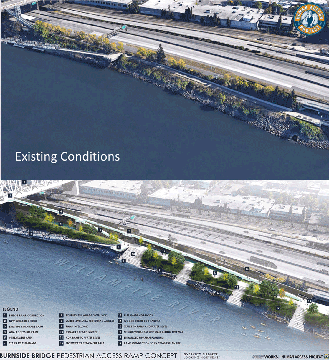
 (Graphics by Human Access Project. Animation by BikePortland)
Could the new “earthquake ready” Burnside Bridge also provide an opportunity to reimagine the public space along Portland’s riverfront? The Portland City Council has voted to spend $20,000 from its Fall Budget Monitoring Process (“Fall bump”) funds to find out.
“Fifty years from now this investment will be a time capsule to the values of our community today.”
— Willie Levenson
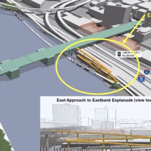
The Human Access Project, a group that aims to make the Willamette River and its banks accessible public space for all Portlanders to enjoy, has asked city council to look at its plan for improving wheelchair and bike accessibility to the new Burnside Bridge that would also provide space for a small park on the east bank of the river between the Burnside and Morrison Bridges.
As BikePortland has previously reported, Multnomah County has gone back and forth on some of the details of the Earthquake Ready Burnside Bridge Project, including about whether to include a ramp for people with bikes or wheelchairs up to the bridge from the Eastside Esplanade. Without the ramp, the only way for people on wheels to get up to the bridge would be via an elevator.
While an elevator is currently a favorite option of project leaders, it would be yet another key connection that is likely to often be broken due to disrepair and lack of maintenance. Elevators at other bridges throughout the city are constantly on the fritz (the Bob Stacey overcrossing being the most recent) and government agencies have a terrible record of keeping them running.
Advertisement
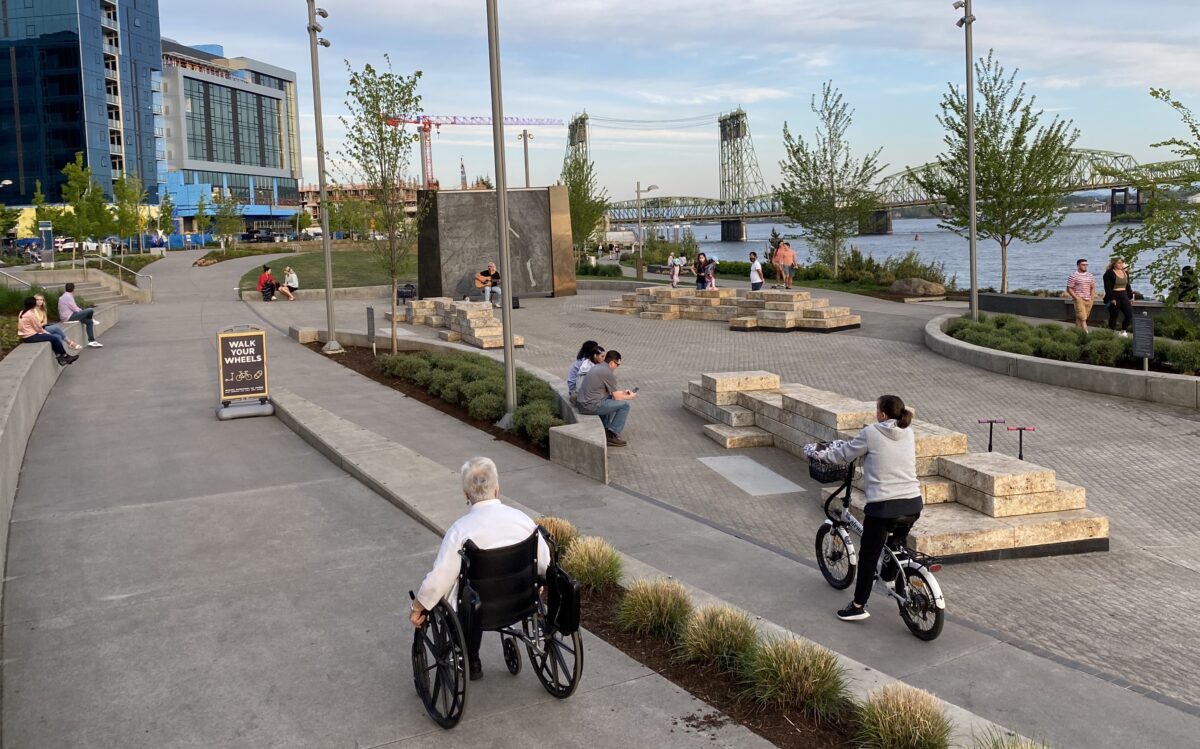
(Photo: Jonathan Maus/BikePortland)
When Commissioner Mingus Mapps brought the amendment the Portland City Council at the November 10 meeting, he spoke encouragingly about the idea of using a project designed for practical benefits — in this case, helping people cross the Willamette River safely in case of an earthquake — to achieve other goals at the same time.
“Instead of just replacing the Burnside Bridge with a new bridge that is more resistant to earthquakes, this is also an opportunity to reimagine our waterfront so that space is greener,” Mapps said.
At the city council meeting, Commissioner Jo Ann Hardesty pointed out that a lot of Portland’s waterfront is currently only accessible to people who live in expensive condos along the Willamette River. Hardesty also said that compared to Vancouver, Washington’s new waterfront development on the Columbia River, Portland is falling behind when it comes to riverfront spaces for people to enjoy, and she hopes this can be an opportunity for change.
The Burnside Bridge replacement project has been estimated to cost $800 million and and Multnomah County officials say they’ve only identified less than half of that. To increase the likelihood of the project being funded and built, they’ve been weighing ideas for how to cut costs. The initial plan was to begin construction on the new bridge in 2024, but as it stands, the earliest the project will get underway is now 2025.
To Willie Levenson of the Human Access Project, improved accessibility and a new waterfront park is worth it.
“Fifty years from now this investment will be a time capsule to the values of our community today,” Levenson said in an email to BikePortland.
If you’re a member of The Street Trust, you can share your opinions on the project at a virtual community conversation meeting today (Monday, 12/6 at 5:00 pm).



Thanks for reading.
BikePortland has served this community with independent community journalism since 2005. We rely on subscriptions from readers like you to survive. Your financial support is vital in keeping this valuable resource alive and well.
Please subscribe today to strengthen and expand our work.
This is still a good idea:
1) A ramp is definitely better than elevators, especially a straight (rather than zigzag) ramp
2) The East Bank Esplanade is very popular, and it’s also subject to noise from I-5. There’s every reason to believe that more park at that location would also be highly used.
The proposal shows a ramp on the south side of the bridge. What would be the route for bicyclists who want to go from the Esplanade into the city center? Similarly, how would bicyclists riding westbound from the east side get to the ramp in order to go down to the Esplanade? I ask because connecting the proposed ramp to the other bicycling infrastructure greatly impacts the usefulness of the ramp.
One solution (which I’ve heard previously related to elevators or zigzag ramps) is a crosswalk and traffic controls to allow people to safely cross Burnside on the bridge at the ramp location. Bicyclists would go up the bridge and cross Burnside to enter the westbound bicycle path.
Another solution would be to run both directions of the bicycle path on the south side of the bridge, so that bicyclists could enter/exit directly from the ramp to the path. The disadvantage here is that westbound bicyclists, when entering the bridge, would have to cross Burnside at the traffic light at MLK to enter the bicycle path. A solution at the east end of the bridge would be to connect both bicycling directions to the Better Naito route. I think westbound cyclists would find that more useful than the current route off the bridge onto Burnside and NW 2nd.
Why not use some of the Federal funds coming our way with recent legislation? Oh wait, those go straight to ODOT.
A few years ago I took some relatives to this area that I exclusively bike. Walking along the highway is a COMPLETELY DIFFERENT experience. It was rather embarrassing showing off one my favorite biking routes to my pedestrian relatives with the ROAR and the pollution of the freeway.
It will be great when the freeway is decommissioned.
According to the graphic, this would be a comparatively easier place to put-in a kayak, iSUP or other small water craft. Going off Duckworth Dock is not easy, and the other place where I have put-in (Northwest side of Broadway Bridge) is better than Duckworth, but has its own problems. Very important with any new river access design…. PLEASE install plenty of bike racks nearby, so one has the option to bike-to-boat.
“At the city council meeting, Commissioner Jo Ann Hardesty pointed out that a lot of Portland’s waterfront is currently only accessible to people who live in expensive condos along the Willamette River. Hardesty also said that compared to Vancouver, Washington’s new waterfront development on the Columbia River, Portland is falling behind when it comes to riverfront spaces for people to enjoy, and she hopes this can be an opportunity for change.”
What a ridiculous statement. There are huge swaths of the riverfront that are very accessible to anyone. Regardless, this is already a nightmare section of the bike path, and the last thing this very narrow strip needs is more people not looking where they are going across the path.
The I-5 exits that hug the waterfront and go onto Morrison are completely redundant and unnecessary. No one would notice if they were removed. Would be a great first step.
One might say I-5 itself from I-84 across the Marquam is redundant — given that through traffic could be easily routed along present I-405 (as long-distance through traffic is already routed along I-205) and there are no exits here besides the one you mention.
There are two infrastructure projects happening here. If Rose Quarter I-5 widening happens, seems like the park aspect of this idea would be an opportunity for ODOT to provide mitigation for impacts to the Eastside Esplanade. As for the Burnside Bridge project, I would much prefer a ramp and stairs over an elevator here for many of the same reasons Jonathan points out.
I would love to bury or do away with this section of I-5, but that seems to be at least 20 years off given that it hasn’t been allocated any funding to even begin planning and engineering. No better time like the present to get that started, but let’s not make perfect the enemy of the good. The river is so barely accessible in the central city that something like this would be a noteworthy improvement.
Meanwhile the North Willamette Greenway languishes.
Since I often find things Mapps is in favor of to be problematic in contrast with (most of) Hardesty’s priorities, I want to go out of my way to highlight another quote from Mapps on this project:
https://www.koin.com/news/where-we-live-burnside-bridge-ramp/
Absolutely right.
Plenty of people swim off the rocks right next to the I5 in between Morrison and Burnside. The filled-in wall of earth cuts down on the noise drastically. This will be used.
I started swimming down off these docks in 2012 and more and more people used it. That year there were about five including my friend who I first accused of being crazy when he told me to do it.
Whether it impacts bikes depends on how it’s designed I should think, but the engineer crowd runs deep on Bike Portland readership so I’ll leave my “expert” input at that.
Removing I-5 is a pipe dream as long as electric car enthusiasm replaces vroom vroom cars—let’s not hold our breath. Pedestrians, swimmers, and bikers and other human powered activities are natural allies.
I wonder if it would be possible to build a sound wall tall enough to quiet the freeway.
Rip out I-5, sell land to highest bidder with no nonsense height or FAR restrictions (sorry western hills nimbys), use massive windfall and permanent annual tax boost to underwrite whatever you need. The cars will find other routes (or disappear into thin air), proven 100x over.
Even Robert Moses wasn’t clueless enough to plan to waste Eastside waterfront property.