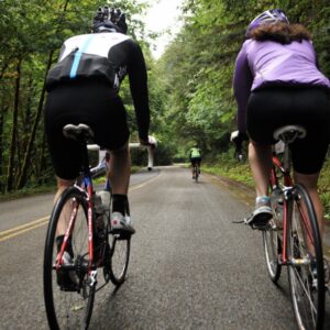
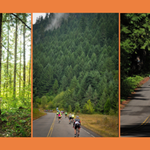
If all goes according to plan, Oregon could add another State Scenic Bikeway to its collection later this year. Advocates and staff from Oregon Parks & Recreation Department hosted a public meeting July 29th to discuss the Aufderheide Scenic Bikeway, a route that would stretch 60 miles between Highway 58 in Oakridge to Highway 126 in McKenzie River.
Oregon’s Scenic Bikeway program began in 2009 as a collaboration between the Oregon Department of Transportation, Travel Oregon, and Cycle Oregon (a nonprofit that provided seed funding). By 2019, when advocates and policymakers celebrated the 10th anniversary of the program at the capitol in Salem, there were 17 routes that had earned the official “Bikeway” designation.
The Aufderheide route would be the 18th and the first since 2017. Also since 2017, the program has been something of a “hot potato” (according to a State Parks staffer) as it seeks a stable home within the state bureaucracy. In 2022, Cycle Oregon stepped up to play a larger management role.


Connor Nolan, the destination development manager for Travel Lane County is the chief proponent of the Aufderheide route. At the recent meeting, he said the designation would help the regional economy and further market itself as a cycling hotbed. “The synergy of having this bikeway really leverages our area as a travel destination and is really important to us and our communities,” Nolan shared.
While the designations are a nice feather in the cap for tourism officials, they don’t come with any infrastructure upgrades. Scenic Bikeway come only with signage and marketing. Asked by a meeting attendee why the routes aren’t made safer with physical changes like protected bike lanes or other hardscape changes, Jenna Marmon with Oregon Parks and Recreation said she’s familiar with that critique.
“I feel more people would ride and spend money if they felt safer,” the meeting attendee shared in a chat window of the online meeting.
“This is one of the primary things we’re hearing right now,” Marmon replied. “This is definitely something we’re thinking about, but as far as funding being available as part of the program, no unfortunately, the program doesn’t fund infrastructure improvements.” Marmon said her team is open to partnering with other agencies and seeking grant funding, “But the program itself, well, we don’t have a lot of money,” she added.
Despite these efforts to officially recognize Aufderheide Drive (also known as Forest Service Road 19), the road sells itself. It’s already a National Scenic Byway and a Scenic Waterway because of its natural beauty as it winds along the North Fork of the Willamette River through old-growth forests and meadows. The route also passes five campgrounds and 25 trailheads, making it a perfect gateway to explorations.
While it seems like a natural fit to become a scenic bikeway; cycling advocates, business interests, and tourism officials have worked since 2013 to get the official stamp of approval. The sticking point has been the road itself. US Forest Service officials said wildfire and related landslide issues were too risky and they didn’t support the designation. USFS has spent $8 million on road improvements since 2016 and with the area more recovered from recent fires, it’s all systems go.
From here, advocates will polish their plan and seek route sign-off from the Oregon Recreation Trail Advisory Committee. Then they’ll present the route to the state parks commission in September. If it’s approved there, it will officially launch in May 2025.


Thanks for reading.
BikePortland has served this community with independent community journalism since 2005. We rely on subscriptions from readers like you to survive. Your financial support is vital in keeping this valuable resource alive and well.
Please subscribe today to strengthen and expand our work.
Such a fun ride! Absolutely gorgeous! A perfect addition to the Oregon Scenic Bikeways!
There goes the neighborhood…bike gentrification, I can hear the drivers complaining already about the improvements 😉
This is good news. It’s been hard watching the Scenic Bikeways program languish the last few years after a period of pretty robust publicity and expansion. Having the Cycle Oregon organization take over planning and development in partnership with the state seems to finally be reinvigorating the program.
Without boasting too much, I like to think of myself as the Scenic Bikeway’s biggest fan. 5 years ago I rode solo from Portland to LaGrande to meet some friends and ride the Grand Tour SB. It’s an incredible route, and was the beginning of my quest to ride each of the 17 routes. I completed the last one in July 2023, all but one was ridden solo, and I camped every night along the routes that were more than a day ride.
IMHO, the criticism of the lack of protective cycling infrastructure is unwarranted. I imagine it comes from people who haven’t actually seen the routes. Safe riding is part of the vetting process for Scenic Bikeways, and the great majority of riding you’ll do on any of these routes is blissfully quiet and traffic free. There are sections of the Blue Mountain Century, the Oregon Outback SB, and the Old West SB where it’s not unusual to not see another vehicle for a half hour or more. And my experience with drivers has been almost entirely positive and friendly. I think that when some people think of “scenic bikeways”, they’re either envisioning Greenways in Portland, or riding the Oregon Coast. The Scenic Bikeways are nothing like that. Check out the videos Russ and Laura made for the Oregon Scenic Bikeways website. They’re entirely representative of the experience of (lack of) traffic you’ll experience on nearly every mile of the Scenic Bikeways. Do not be afraid to ride these routes.
Can anyone verify if it’s currently open to ride? Fires in this area (almost annually the past few years) and consequent area closures have always been a bit difficult to discern. Perhaps making it a Scenic Bikeway would put it on a site that makes it more clear whether or not it is open, or what portions are closed. Thanks.
Always a good question this time of year. I was camping there a few weeks ago just south of Cougar Reservoir and it was open, though a bit smokey off and on. My impression from the Willamette Nat. Forest website is that it’s now closed due to the Chalk fire: https://www.fs.usda.gov/alerts/willamette/alerts-notices/?aid=61574
This is a pretty good resource for fire status in Oregon; https://gacc.nifc.gov/nwcc/firemap.php
OK so … what does the designation get us? Just some signage and marketing?