Surely we can fit bus lanes here. Right? Right! (Photo: Jonathan Maus/BikePortland)
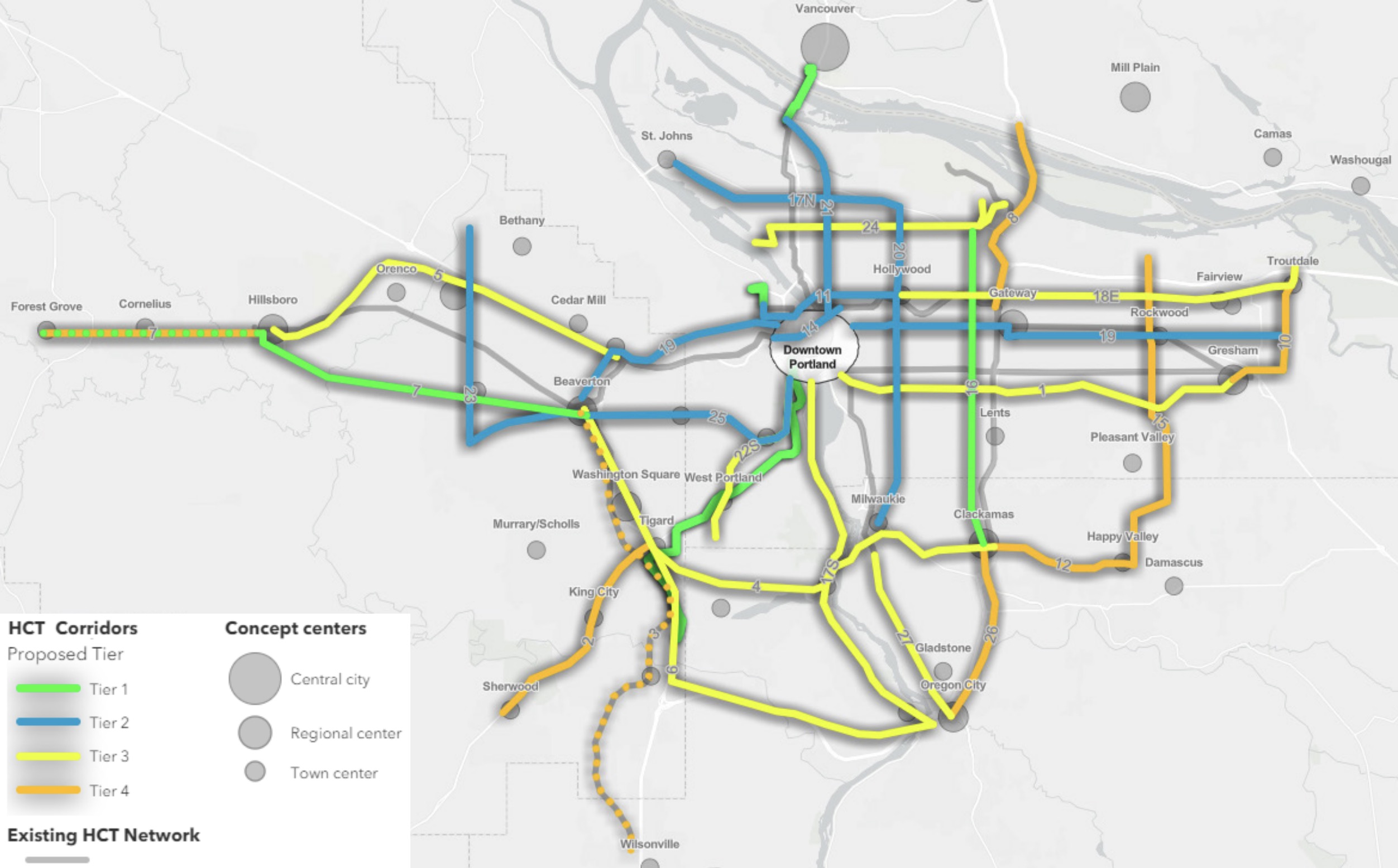
Metro High Capacity Transit Corridors map (bright green are Tier 1).
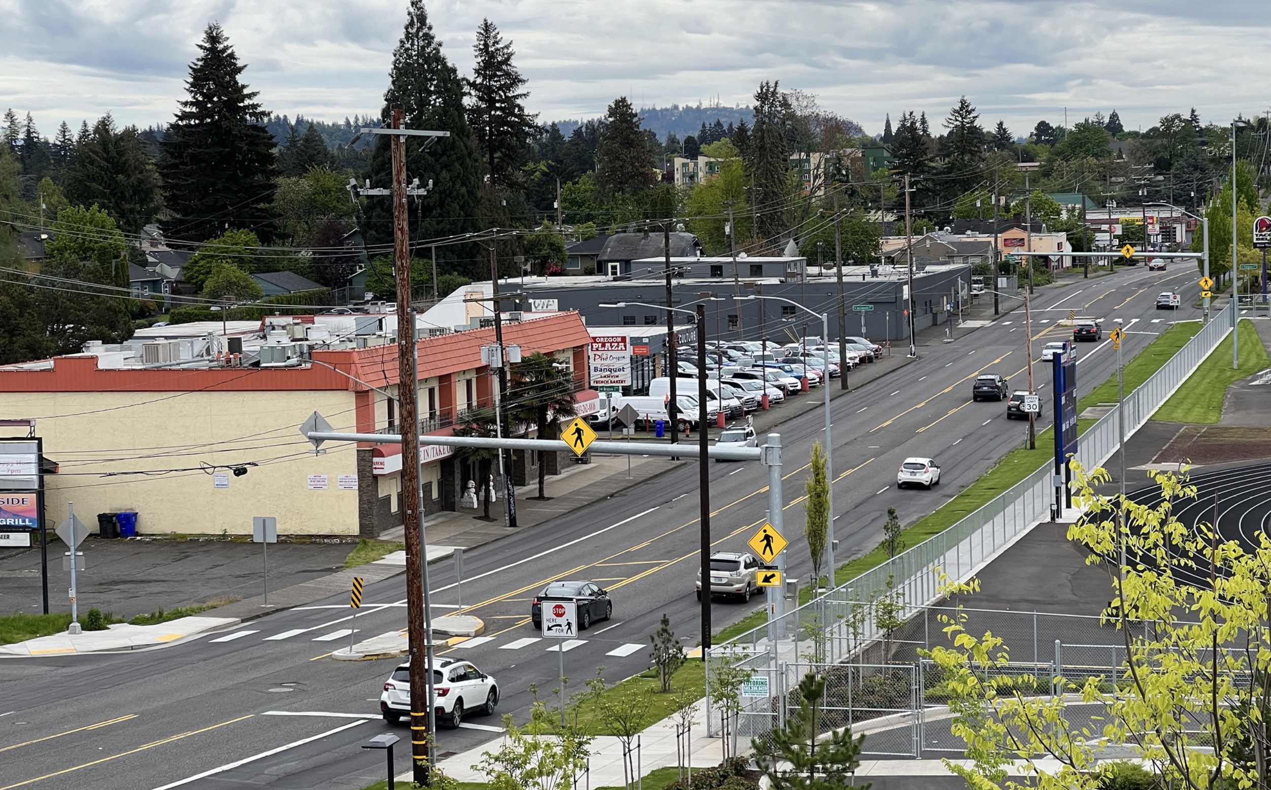
A plan to bring faster and more reliable bus service to 82nd Avenue has started in earnest. The effort will be led by Metro in partnership with the City of Portland. Initial planning stages are underway and Metro says they have an eye toward bringing a version of TriMet’s new Frequent Express (FX) service to this former state highway (you might recall that the City of Portland became the official owner of 82nd Avenue when the jurisdictional transfer from the State of Oregon was completed in April 2022).
82nd Avenue is home to TriMet Line 72, which has the highest ridership of any bus line in the Portland area. It carries an estimated 8,500 riders on an average weekday and runs from Clackamas Town Center to northeast Portland’s Roseway and Sumner neighborhoods. Improving bus service on 82nd has been identified as a top priority in the Regional Transportation Plan and Metro’s High Capacity Transit strategy lists an FX-style bus (like the one TriMet just opened on SE Division) alongside four other Tier 1 projects: Southwest Corridor MAX, Tualatin-Valley Highway FX bus, Interstate Bridge MAX and Montgomery Park streetcar.
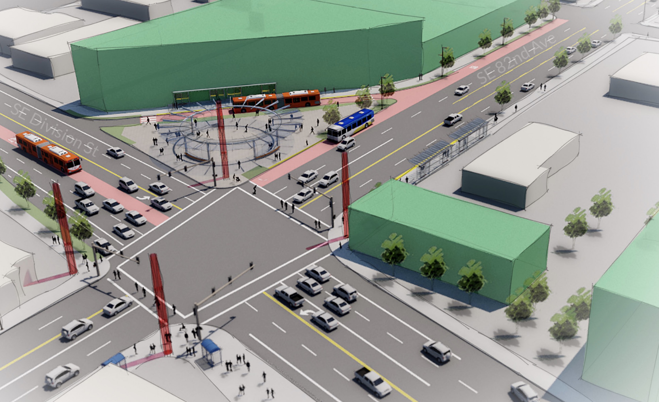
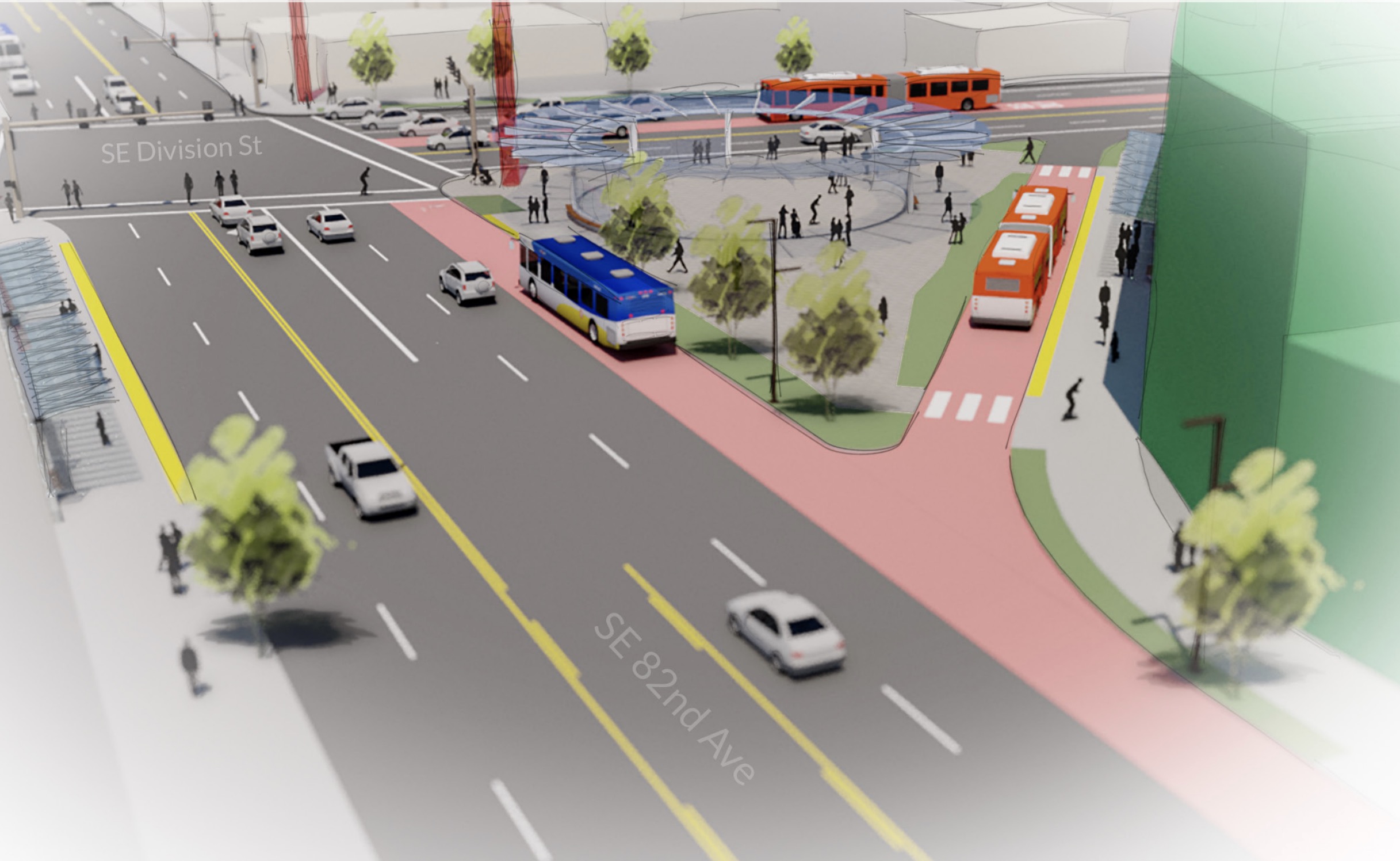
If this feels like deja-vu that’s because we’ve been here before. There was a serious look at bus rapid transit on 82nd as part of the initial plans for the Division Transit Project in 2016 (back then it was called the Powell-Division Transit and Development Project). But it was scrapped at that time because ODOT wasn’t ready to restrict driving capacity on 82nd that would have been necessary to speed up buses (and the options to widen the street were consider too expensive or politically infeasible).
Now we’ve got another chance to do something big on 82nd. And this time around, ODOT won’t have nearly as much say in the matter since they only own the portion of 82nd from the Clackamas Town Center to the city limits.
TriMet conceptual drawings from their 2016 proposal for bus rapid transit on 82nd Avenue.
In a factsheet published back in October, Metro wrote:
Bus rapid transit service would significantly improve travel time, reliability, and comfort by allowing the bus to separate from or bypass other vehicle traffic in key areas along the route and improving stations.
Metro’s High Capacity Transit strategy specifically calls out projects that “provide better alternatives to driving that encourage new ridership in support of the region’s climate goals.” Metro, which thinks of high capacity transit as the “backbone” of our regional transportation and growth plans, has been putting the pieces in place for major transit investments since 2009 when they adopted their Regional High Capacity Transit (HCT) System Plan. In an update of the 2018 Regional Transportation Plan they introduced the Enhanced Transit Concept, which they now call “Better Bus.”
The “better bus” project on 82nd has even more momentum right now because it’s being timed to take advantage of the $185 million pledged by ODOT and the Portland Bureau of Transportation as part of their Building a Better 82nd Avenue plan.
The timeline is to develop the design concept now through this spring and then a steering committee will identify a locally preferred alternative this summer. Local and regional governments will be asked to adopt the project this coming summer and fall. Metro will apply for federal grants and begin the National Environmental Policy Act (NEPA) process will in 2024 and it is scheduled to open in 2029.
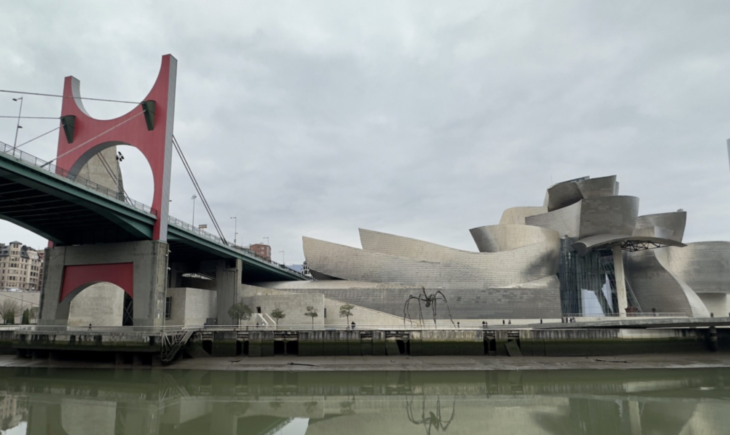
The Frank Gehry-designed Guggenheim Museum Bilbao. (Photos: Taylor Griggs/BikePortland)
— This post is part of BikePortland Staff Writer Taylor Griggs’ trip through Europe. See previous dispatches here.
Bilbao’s renewal was accompanied by a new public transit networks that spread all around the city as well as a citywide commitment to biking and walking infrastructure.
The Spanish city of Bilbao is home to about 350,000 residents, is the biggest metropolis in northern Spain’s Basque Country, and its natural beauty and unique history should be attractive to European travelers looking for something a little different. But it’s the armchair urbanists who will really find a treasure trove of riches in Bilbao.
Alright, maybe I’m just late to the game. After all, Bilbao is well-known enough amongst city planning aficionados to have an architectural concept named after it. The “Bilbao Effect” is a term coined after the 1997 construction of the Guggenheim Museum Bilbao structure: an eye-catching and critically-renowned piece of contemporary architecture that launched designer Frank Gehry into “starchitect” status à la Frank Lloyd Wright (who, of course, designed the famous Guggenheim building in New York).
While the Guggenheim Bilbao is notable for its world-class contemporary art collection, it’s the building that really sold it as an attraction worth traveling to Basque Country for. This is exactly what Bilbao politicians wanted when they appealed to the Guggenheim Foundation to build their next museum in their city, considering it their one great shot at revitalization after years of economic turmoil. And it worked, heralding substantial urban development projects like a robust Metro and tram system, beautiful parks and public spaces and more. But was there a cost?
A 2017 Guardian retrospective on the Gehry Guggenheim building includes a quote conveying the architect’s unease upon seeing his bright, extravagant building in Bilbao for the first time: “I went over the hill and saw it shining there. I thought: ‘What the fuck have I done to these people?”
Another view of the museum.Me inside the Guggenheim’s current Yayoi Kusama piece.The Jeff Koons ‘Puppy’ installation. It reminded me of a beautiful Chia Pet.
I started learning about Bilbao in bits and pieces only recently, when my sister moved here to teach English for a year. I had never given much thought to visiting Basque Country, and I was very surprised to hear about how prevalent Basque culture and language is in this city.
When the Guggenheim opened in 1997, some Basque separatists violently protested. Other detractors thought of the museum as an example of American globalism, calling it “McGuggenheim.” Guggenheim naysayers feared that Bilbao’s shiny new tourist attraction and subsequent urban renewal would come at their their city’s authenticity, affordability and perhaps even the future possibility of an independent Basque Country.
From what I can tell, however, the consensus now is that the museum had a positive effect on the city, including for its Basque population. But this is only because Bilbao’s government worked hard to make sure the entire city was able to reap the Guggenheim rewards and its impact wasn’t isolated to a small, touristy area of the city where visitors would stay. If not done thoughtfully and with long-term planning, big tourist installments like this can wreak complete havoc on a city’s inhabitants — think what can happen in short-sighted cities after they host the Olympics.
Closer to home, debates about gentrification and urban renewal projects play out on a smaller scale all the time. The discourse can be hard to keep track of. (For instance: I have no idea what the temperature is on Portland’s new Ritz-Carlton, and at this point I’m too afraid to ask.) People whose worldviews are otherwise aligned can find themselves in uproarious arguments (usually on Twitter) about whether or not luxury condos or new fine dining restaurant establishments are useful to solving the affordable housing crisis or revamping Portland’s economy.
What I’ve learned from Bilbao is that a city is worth a lot more than its most “impressive” structure. It’s going to be tempting to use the existence of new luxury buildings or tourist attractions as a “gotcha” against accusations that Portland is dying, but we’re not going to get very far with that. To me, Portland’s joie de vivre is best embodied by grassroots community activities like Pedalpalooza, the Secret Roller Disco and even the fledgling local arts movement happening at the Lloyd Center.
Like I mentioned, Bilbao’s renewal was accompanied by a new public transit networks that spread all around the city as well as a citywide commitment to biking and walking infrastructure. Now, this city is topping national lists for its high pedestrian mode share (62% of all trips are taken on foot!) encouraged by the government with carfree streets in the city center and gorgeous pedestrian bridges. Bilbao isn’t necessarily known for its bike-friendliness, but I’ve been impressed by the grade-separated bike path network extending throughout its neighborhoods. If Portland’s so-called “rebirth” came with a similar move away from car infrastructure — a strategy with proven economic benefits — I think we could have a similar trajectory.
In Bilbao, beauty extends far beyond Gehry’s building. If the Guggenheim’s titanium panels — and even the Jeff Koons’ ‘Puppy’ installation on the lawn — were to suddenly disappear without a trace, the city would still be worth visiting. More importantly, it would still have resources for the people who actually call this place their home. That’s the part of the “Bilbao Effect” we need to emulate. Of course, the world-class, deconstructionist movement architecture and access to famous contemporary art is cool, too…but it’s not everything.
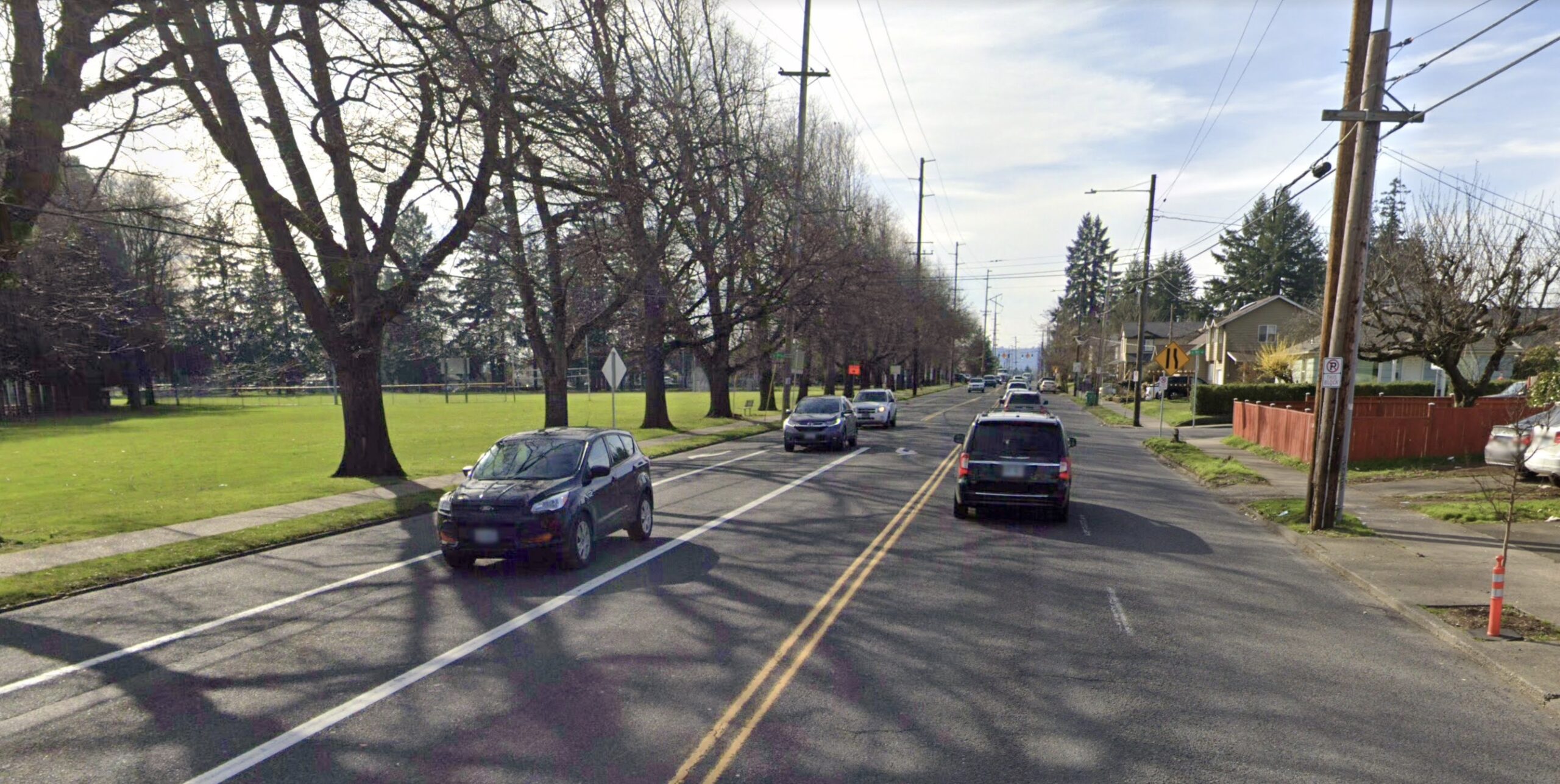
SE Holgate just west of 92nd, where someone was killed while walking this week.
A nonprofit that pushes for safer cycling has swung into action following a traffic collision on Southeast Holgate that left someone dead early Monday morning.
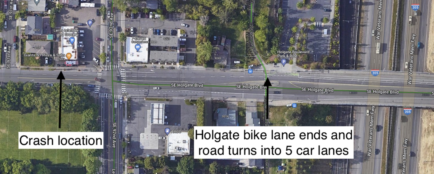
According to the Portland Police Bureau, they responded to a call just after 3:00 am on Holgate just west of SE 92nd Avenue. They found a person in the road with severe injuries and a car driver who had stopped to see what happened. The injured person, who police say was a pedestrian, died shortly after at the hospital. It was the third person killed while using this intersection since 2016.
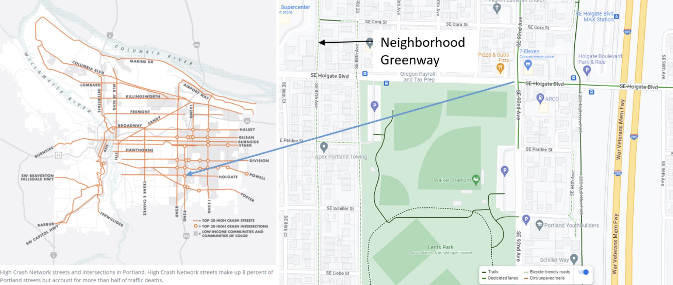
This stretch of Holgate is adjacent to Lents Park and has a tragic history of deaths and injuries. The Portland Bureau of Transportation ranks it ninth citywide on its list of high crash intersections. Between 2015 and 2019, two people were killed, five people were seriously injured and 44 other people suffered minor injuries due to traffic crashes at this location.
(Source: BikeLoud PDX)
BikeLoud PDX is dismayed that the street outside Lents Park is so dangerous. In a letter sent Wednesday to PBOT Commissioner Mingus Mapps, PBOT Interim Director Tara Wasiak, and members of the city’s Bicycle Advisory Committee, BikeLoud Chair Kiel Johnson wrote, “We ask for an immediate traffic safety solution at SE Holgate and 92nd and a plan to extend the bike lanes from the Holgate Transit Station to the neighborhood greenway on 87th Avenue.”
In 2009, PBOT installed buffered bike lanes on Holgate from SE 122nd to the I-205 bike path, but the lanes end about one block east of 92nd. BikeLoud wants PBOT to extend the bike lanes about 0.3 miles west to an existing neighborhood greenway on 87th. In their letter, they argue that buffered bike lanes also offer pedestrians a safe space and can improve visibility for people trying to cross the street.
We don’t yet know what exactly happened early Monday morning, but when PBOT first installed the bike lanes on Holgate they reported a 19% decrease in the number of people driving over the speed limit.
Johnson and BikeLoud are calling on PBOT to live up to their Vision Zero commitments which call on the city to respond to every fatal crash with an evaluation of how it happened and to determine what safety changes are needed. “Where feasible,” reads PBOT’s Vision Zero website, “put swift, temporary traffic and operational changes in place.”
“The section of Holgate where this crash occurred is dominated by space for cars,” Johnson writes in his letter. “It took two months for PBOT to reinstall the green bike boxes at SE Powell and 26th after Sarah Pliner was killed. We hope that PBOT can work just as quickly to extend the Holgate bike lanes and make this stretch of Holgate safer for all road users.”
So far this year, three people have been killed while walking on Portland streets. Just last night someone was hit by a driver and killed while walking across SE Powell and Foster Road.
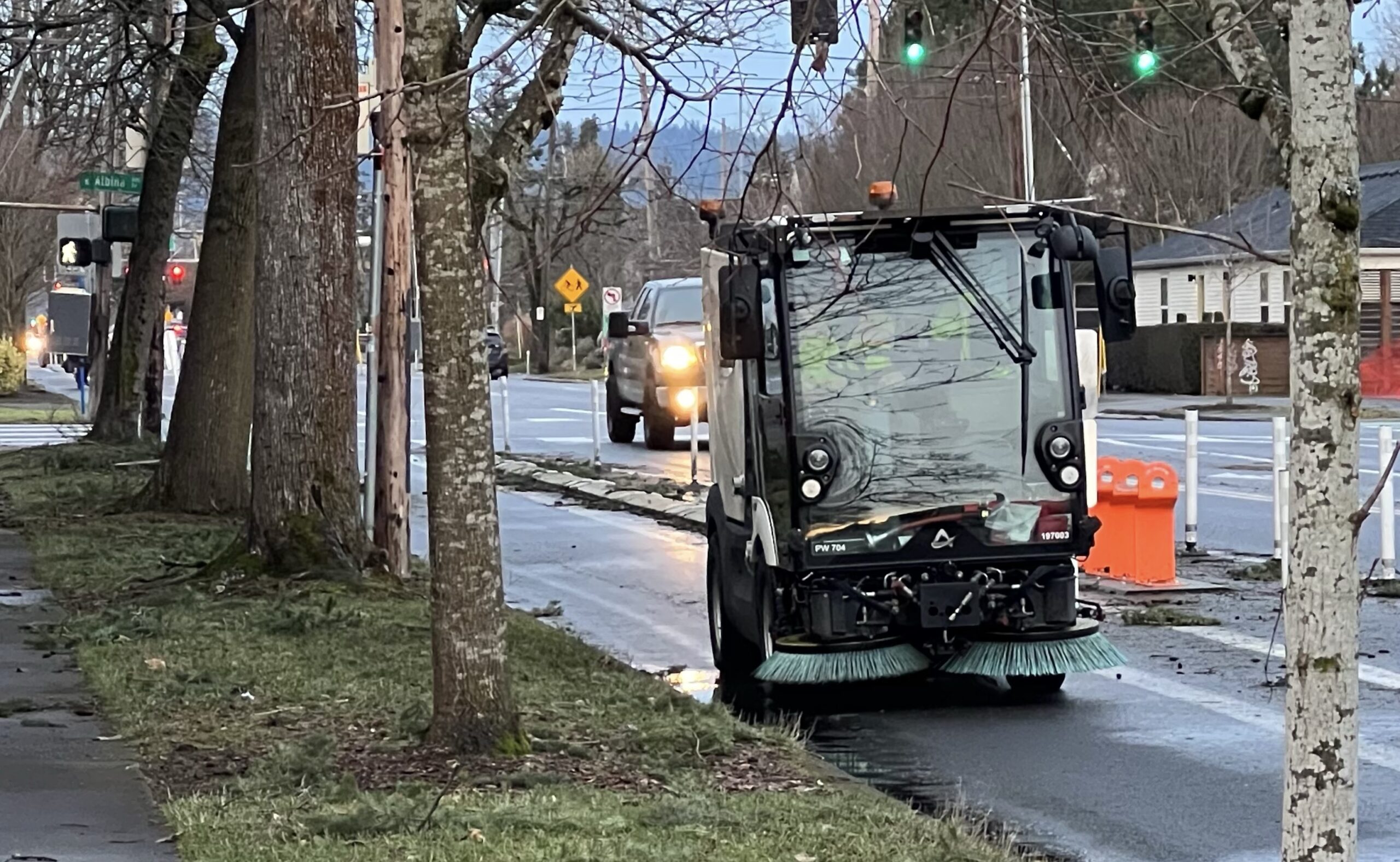
City of Portland sweeper operator cleans a bike lane on North Rosa Parks Way. (Photo: Jonathan Maus/BikePortland)
“We’re making plans to be able to provide core emergency response services, but it will be a challenge without the staff that does the work day in and day out.”
— City of Portland maintenance worker
Labor contract negotiations between the City of Portland and employees represented by Laborers Local 483’s Portland City Laborers (PCL) contract have been underway for months to no avail. Now, citing insufficient concessions from the city, PCL workers have made it officials: they plan to strike as soon as next week.
According to NW Labor Press, 630 parks, environmental services and transportation bureau workers are ready to walk out.
The PCL contract includes Portland Bureau of Transportation maintenance workers who are in charge of street upkeep, striping bike lanes and crosswalks and more. The union says these employees have been working under poor conditions for years now, but the pandemic and subsequent economic inflation exacerbated the situation — and this is getting in the way of their ability to keep up with the very important work of maintaining our streets.
“Union workers under the PCL contract took nearly 2.5 million dollars in concessions at the beginning of the pandemic. They delayed negotiating a new contract for a year to accommodate the City of Portland in its time of need. In response, City decision makers have treated their safety and financial security as a low priority,” a Tuesday press release from Local 483 states. “These workers run our sewer systems, build our roads, maintain our parks, and much more. They are the workers who showed up, in person, throughout the pandemic to keep our City running.”
A Local 483 graphic depicting current pay for PCL members compared to rising inflation.
According to an article posted yesterday by The Oregonian, the City of Portland has proposed a 4-year, $39-million contract with a 12% wage increase by July, which would include a retroactive cost-of-living adjustment (COLA) of 5% and a 1% retroactive across-the-board pay raise.
Local 483 says this proposal is inadequate. The union wants a 3.5% across-the-board pay raise for all members and is asking the city to remove its 5% COLA cap, which doesn’t keep up with inflation. Anything less amounts to a “pay cut” under our current 6.5% inflation rate, Local 483 leaders wrote in a December bargaining update.
They’re not buying the city’s excuses for why they can’t meet those demands.
“The City continues to plead poverty. The PCL Bargaining team has been unconvinced by the City’s argument given the facts as we understand them. Portland’s budget assessment process has consistently “found” tens of millions of dollars, every 6 months, for years,” another recent bargaining update states.
As recent BikePortland stories have touched on, the maintenance issues on our streets have become more and more evident recently — especially for active transportation users. From hazardous, invisible ice on the streets and sidewalks to lake-sized puddles in bike lanes, there’s a lot someone walking or biking needs to look out for when trying to get around the city.
PBOT officials cite the bureau’s $4.4 billion maintenance backlog as the reason they can’t get these problems under control, and say they’re working to develop a new funding structure that would allow them to get ahead of it.
But Local 483 leaders say nothing will change until maintenance employees are respected. And if that means going on strike, so be it.
“We view this contract as an opportunity for the City to honor the sacrifices of workers who have shown up through recent years of crisis. Additionally, money spent on the PCL contract is a sound financial investment. It resources necessary work that provides real value for the people of Portland,” the Tuesday press release reads. “Without that investment, it is likely that the City will see substantial costs associated with the inability to recruit and retain the people needed to avoid catastrophic failures.”
“We’re making plans to be able to provide core emergency response services, but it will be a challenge without the staff that does the work day in and day out,” said one maintenance staffer who spoke to us on the condition of anonymity.
Local 483 will hold a gathering for PCL union workers this Saturday, January 28th from 12 to 3 pm in Terry Schrunk Plaza outside Portland City Hall to ask the city to meet their demands. They invite the public to attend and show their support. You can find out more about the event and the PCL bargaining process at the Local 483 website.
(We have also heard that remaining City of Portland non-represented staffers who aren’t members of Local 483 are planning to form a union of their own. According to the website of the City of Portland Professional Workers Union, 321 non-represented city workers have joined so far.)
Five kids in the box (one is hard to see), Mom at the pedals, two kids on their own bikes.
I never thought biking could actually be the mobility solution to one of our big family’s real mobility problems: too many kids for our minivan.
We have a big family. Two adults and five children. That maxes out the seating in our seven passenger minivan. We can’t pick up friends or volunteer to drive another kid home. If our family grows any bigger, or if we are hosting a niece or nephew, or babysitting for friends, we don’t have a car that can carry us all.
As a result, we’ve been shopping around for a way to meet our big family transportation needs. We’ve been looking at old shuttle vans, Ford Transits, Chevy Expresses, actual shuttle buses, half buses and even old school buses. But it’s a potential purchase that I’m particularly unhappy about. I loathe the idea of driving a bigger vehicle (so much so, that I looked into importing a smaller-sized Japanese vehicle that could seat more folks in a smaller footprint with a much lower vehicle weight, and at a much lower cost – but that’s another story). And I practically want to launch a campaign against heavy super-sized and often unneeded SUVs and their threat to children and the people outside of them. The last thing I want to do is drive one myself!
Long rant short: I love children. I loathe extra-large vehicles for carrying them.
Then when the Alameda Bike Bus made headlines it got me thinking. That’s a whole lot of kids, way more than I’ll ever have, all riding along on one giant bike bus. Could that be the transportation solution for our big family?
I never thought biking could actually be the mobility solution to one of our big family’s real mobility problems: too many kids for our minivan. Perhaps that’s because the common image I have of family biking looks like one grown-up with one or two kids in child seats or a two-seater trailer. (Those trailers don’t come any bigger!) Perhaps that’s because I don’t see a lot of big families out biking. Or perhaps I am still so heavily influenced by car culture that I can’t see past it, even when the bike is sitting right in front of me.
I am the happy owner of a large electric cargo trike. I can seat at least four kids in my cargo box, or even five or six if they are small toddler-sized people willing to squish a bit. After that, when it comes to independent kid riders, I can take as many as I feel comfortable shepherding. There isn’t a strict maximum. With kids riding their own bikes, we don’t run out of seats. We don’t outgrow the bike bus.
Our first trip on the family bike bus took off today. I was babysitting two extra kiddos, putting the total at seven kids and one grown-up, which is too many for our seven-seat minivan. That would mean we would have to stay home (all day with seven children under age ten, no thank you!) or we could make our own bike bus ride to the park.
Thus, the Johnson Family Bike Bus went on its very first ride. Five kids in the cargo box with me at the pedals (thank you e-assist!), and two kids riding on their own. In the middle of January no less!
It was fabulous. Which is saying a lot, when one is spending the day with seven children. We needed the bike bus today. We needed to be able to go to the park and run around and yell. And our minivan couldn’t take us there. But with bikes, we could.
And for those with even bigger families, check out the Bunch Bike Preschool (or big family) model, which seats six little people in the cargo box. It will seat as many as a minivan, with a much smaller footprint and price tag, and it looks like so much more fun.
Normally, we bike because we want to. Today, we biked because we couldn’t drive. And now, I can see us doing a lot more of that, like bike pick-ups of friends and riding together for outings and playdates, because whoever can ride their bike can join us, no car seats required.
Tabor is a nice place to bike, but not everyone knows what areas are off-limits for off-roading. (Photo: Jonathan Maus/BikePortland)
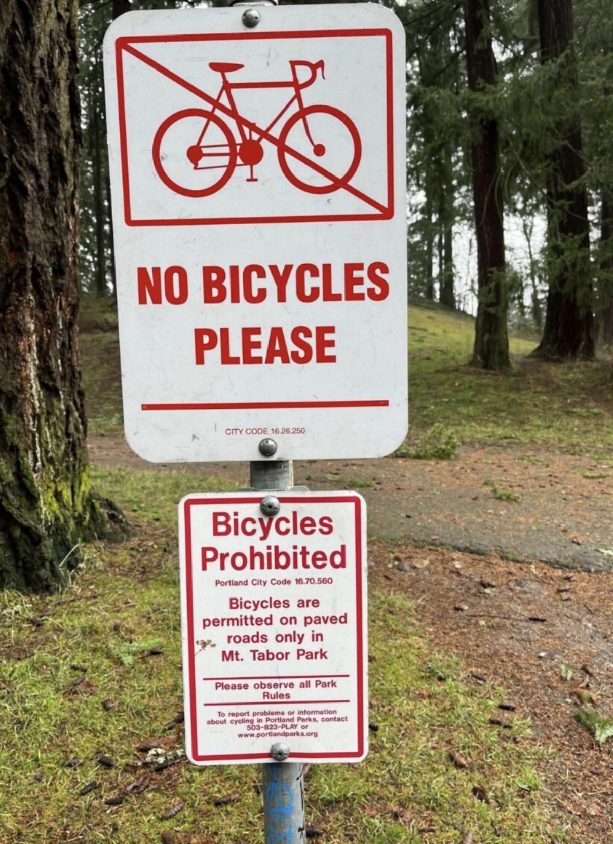
The (now removed) sign. (Photo: Carrie Leonard)
It’s one thing when when haters or NIMBYs put up an anti-bicycling sign. It’s another thing when a city government staffer does it. And it’s on a whole different level when a city staffer does it with what feels like an intent to push an agenda that doesn’t even align with city policy.
That’s why I and many readers were so dismayed by the signs installed in Mt. Tabor Park late last month. When an eagle-eyed reader first told me about the signs, they seemed so legit that I immediately gave the Portland Parks & Recreation bureau the benefit of the doubt. But as I looked into it further and then heard from another reader who had similar concerns, the incident came into focus. As I reported last week, a Parks staffer acknowledged the signs were legit and told the concerned citizen that the signs aligned with their preference for keeping bicycles off unpaved roads in the park.
The problem of course, is that bikes are actually allowed on some unpaved roads and paths in the park. And the signs — which were erected in a misleading location — also referenced nonexistent and non-applicable city code in what appeared to be an attempt to threaten law-abiding park users with enforcement. Thankfully Parks took down the signs once the situation became public.
Even though the signs were quickly removed, I remained unsettled about the idea that there might be rogue city employees using our tax dollars to create and install bogus, anti-bicycling signage. I emailed Parks Commissioner Dan Ryan’s office to ask if my view of the incident was correct. And if I was reading the situation correctly, I wanted to know if that employee (or employees) would face any discipline.
Ryan’s office passed my inquiry over to Portland Parks media relations leader Mark Ross. He said the sign was installed in error and there is no disciplinary action planned for any employees. Ross referred to the episode as a “mistake” (he previously said it was “unintentional”). Ross also said:
“Portland Parks & Recreation appreciates a neighbor bringing it to our attention. We are making sure that staff across the Bureau follow protocols about ensuring content is accurate and appropriate before signs are installed in the Portland Parks & Recreation system.”
Ross then reiterated that Parks is working on creating a clearer map (confusion over usage rules at Mt. Tabor Park have led to people yelling at bike riders) and a “system-wide comprehensive signage program that will prioritize safety and be informed by city code.” Ross added that they intend to look at bureau-wide signage practices in order to “improve protocols and avoid errors going forward.”
I’ve heard Ross mention that effort before, and it sounds like something that will improve our Parks for everyone. When asked for more details, Ross said Parks has not yet identified a project manager but the effort is in the planning queue. That’s a good sign. We’ll keep our eyes and ears open for an developments.
My experience may have been slightly troubled, but Paris clearly has the community support for better biking and rolling infrastructure from its citizens! Active transportation joy abounded. (Photos: Taylor Griggs/BikePortland)
— This post is part of BikePortland Staff Writer Taylor Griggs’ trip through Europe. See previous dispatches here.
After multiple consultations at two different medical centers, I wound up on the operating table getting my finger sewn up
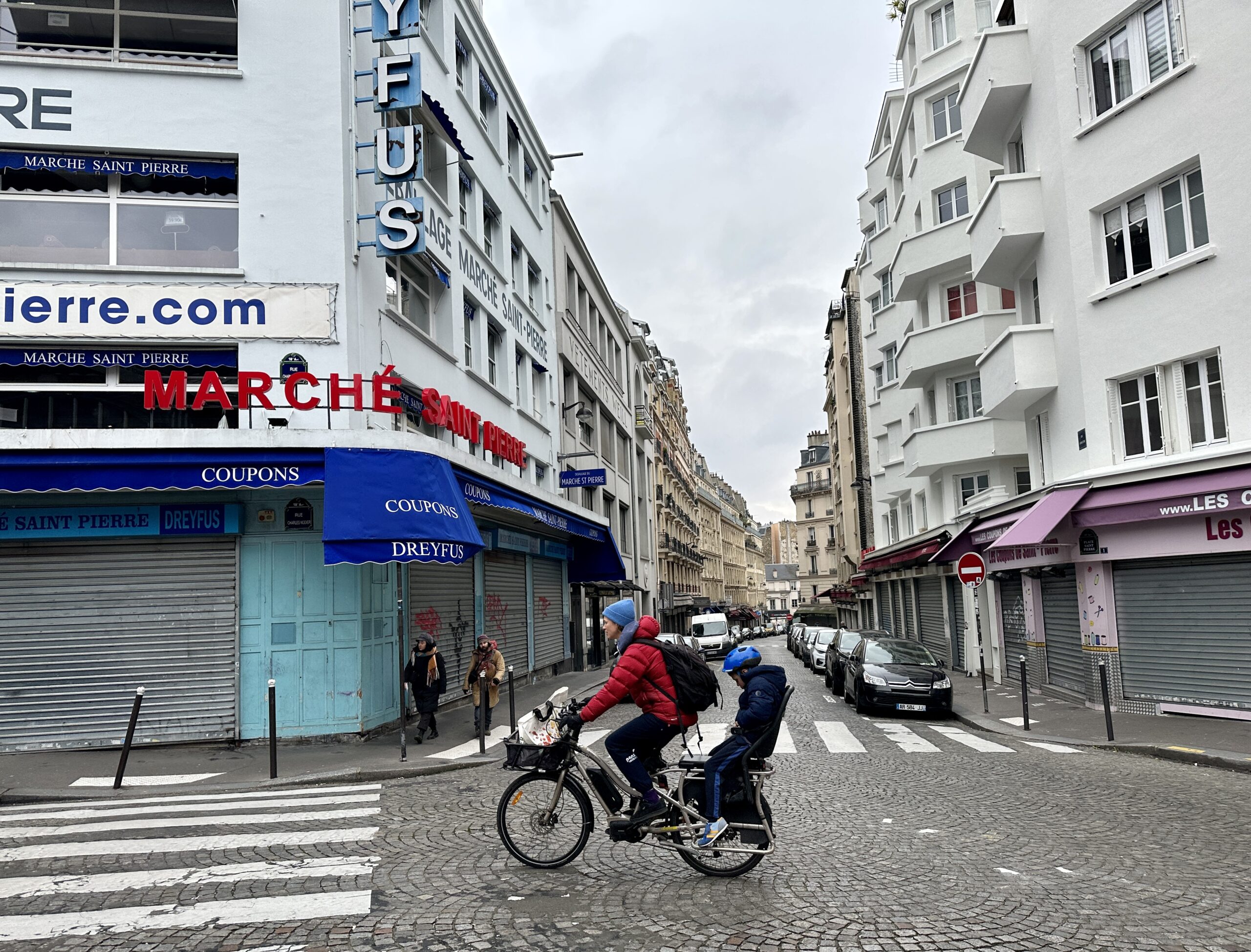
Paris is known for a lot of great things, but unlike the European bike capitals of Amsterdam and Copenhagen, biking facilities haven’t historically been one of them. That is, until recently. Paris Mayor Anne Hidalgo has become an icon among those of us who follow global bike news for her campaign to make the city “100% bikeable” by 2026, a plan with a nearly $300 million budget for separated bike lanes and bike parking spots.
I’ve had a somewhat fraught relationship with the City of Lights in the past, having been targeted for theft three separate times in a week when I visited in 2017 (I lost my suitcase of clothes, my phone and nearly my passport). If it weren’t for all the new cycling buzz, I might’ve skipped over it this time around. But after hearing about the Parisian bike revolution, I was sure to add the city to my list of places to visit in Europe. And when I arrived last week, I was excited to rewrite the script for “Taylor in Paris” with a happier — or at least uneventful — ending.
How did that turn out, you might ask? Well…
An American (biking) in Paris
Selfie from the hospital.
I wanted to meet with a Paris bike advocate to find out how they’d been able to encourage the city to take such rapid action on a scale very rarely seen in the United States. So I emailed the organization Paris en Selle (Paris in the Saddle), which has been working since 2015 to hold their government accountable and make Paris a better city to bike in, and I heard back from Alexandre Becker, who offered to take me on a tour of some of the new infrastructure. He also kindly offered to let me borrow one of his bikes to use throughout my stay.
We planned our tour for Friday, but I went to meet Becker on Wednesday afternoon to pick up the bike. We ended up getting lunch and chatting a bit about Paris en Selle’s approach to advocacy. One thing Becker told me during our lunch is that he’s noticed people being a bit disappointed by the reality of Paris’ current cycling infrastructure compared to the hype it’s been getting in the media.
“Oh, I don’t know about that,” I said.
About an hour and a half later I was in the emergency room trying to explain the big gash in my left hand to a group of French-speaking medical staff.
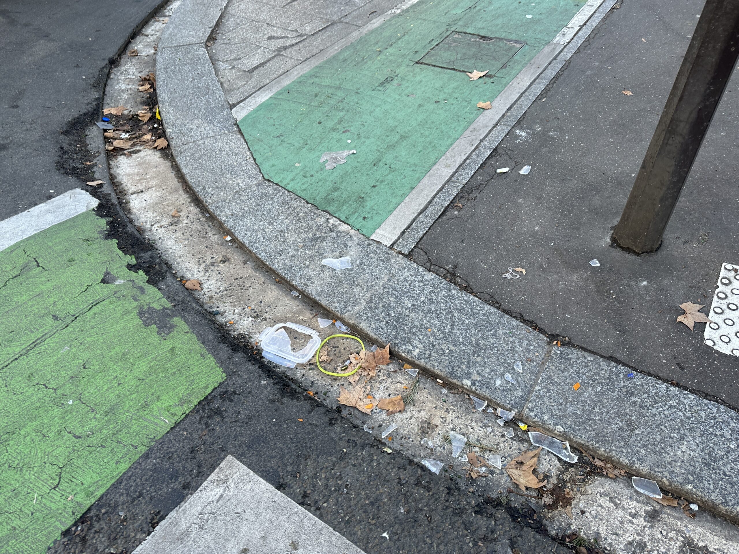
The bike lane bump in question. (Pictured broken glass was not my doing!)
Here’s what happened: after I said au revoir to Becker, I took off on his bike to see the city. It was sunny out, the birds were chirping and all was going well until I hit an unexpectedly deep bump on the parking-protected bike lane I was riding in. I was riding a Dutch-style bike with coaster brakes —which I already wrote about using in Amsterdam and thought I was pretty adept at by that point — and I momentarily forgot how to brake in time to course-correct gracefully. I ended up with my left hand inside the rear light of a parked car adjacent to the bike lane and a really nasty cut on my pointer finger.
At first, I was just embarrassed — my typical reaction to wiping out on my bike. But after some persuading from concerned bystanders, I realized the situation was pretty serious and I should probably get medical attention. I wrote my number down on a piece of paper and taped it to the car with the light I had just smashed and headed to the hospital.
After multiple consultations at two different medical centers, I wound up on the operating table getting my finger sewn up by orthopedic specialists who wanted to make sure I hadn’t hit an artery or given myself serious nerve damage. All is well now — my finger should heal just fine. I also met a lot of interesting, kind people and was able to experience life in a country with a humane healthcare system (my entire medical treatment cost $0, can you even imagine?). But an uneventful week in Paris? Not a chance!
Where does Paris stand on cycling?
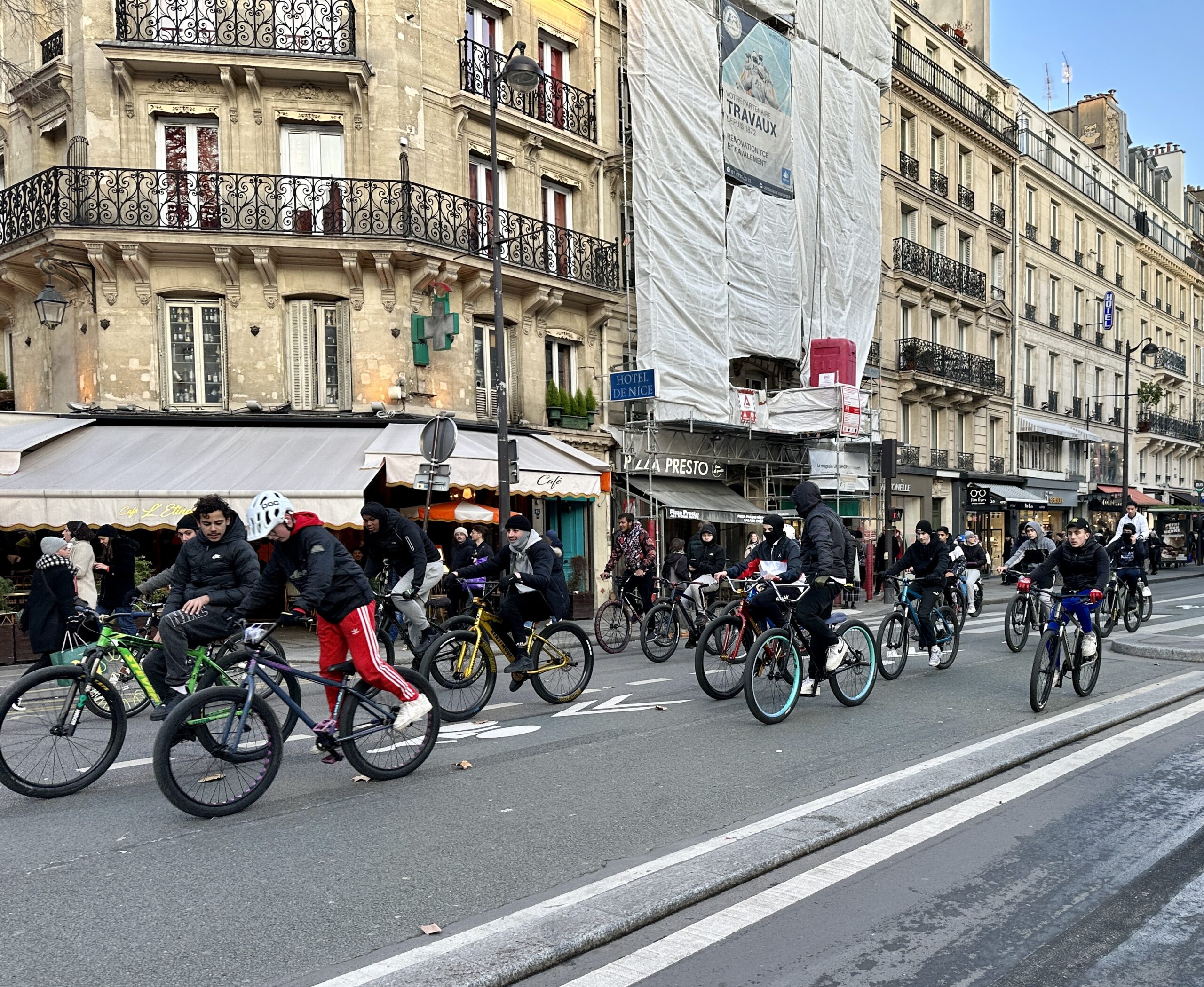
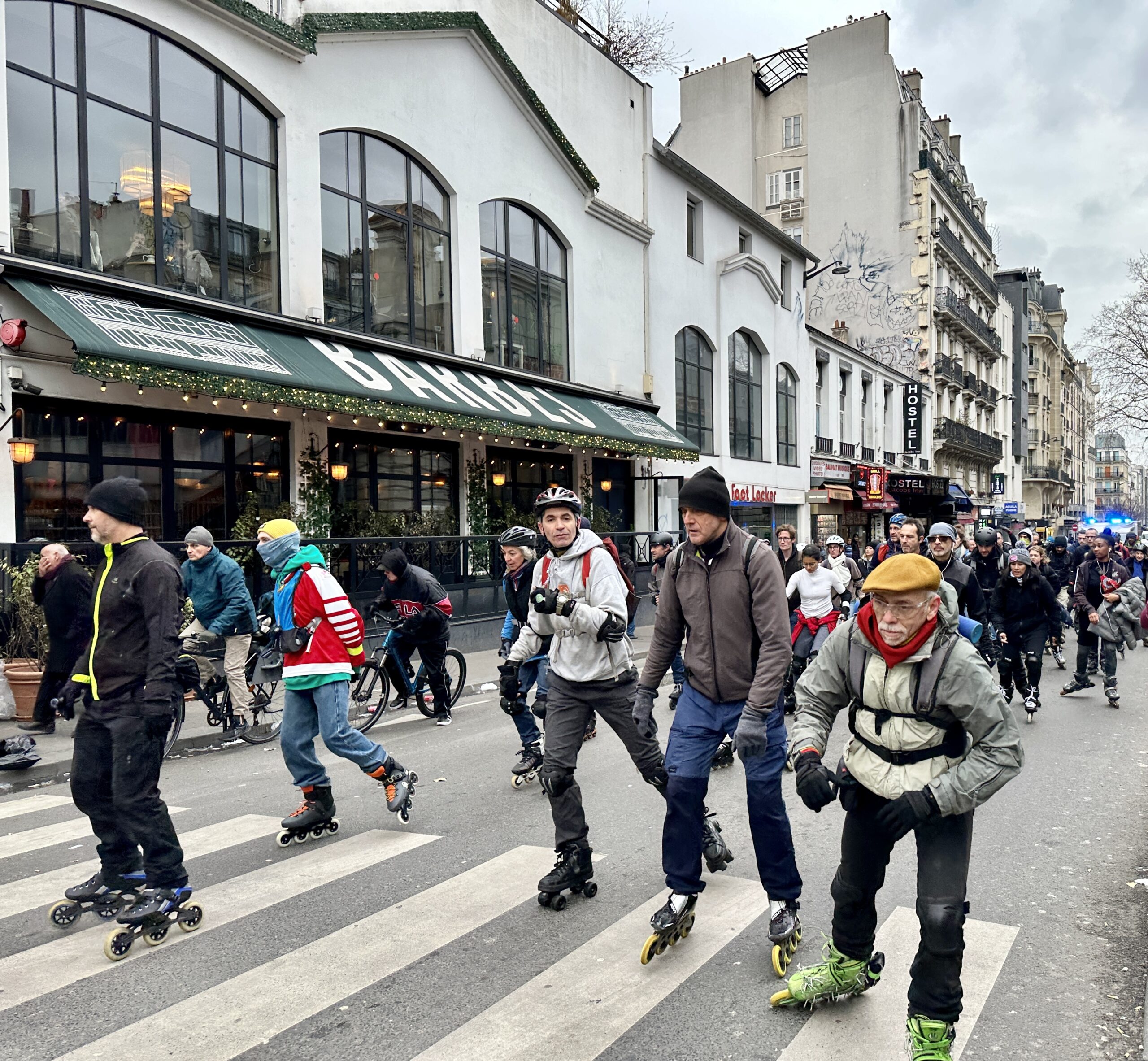
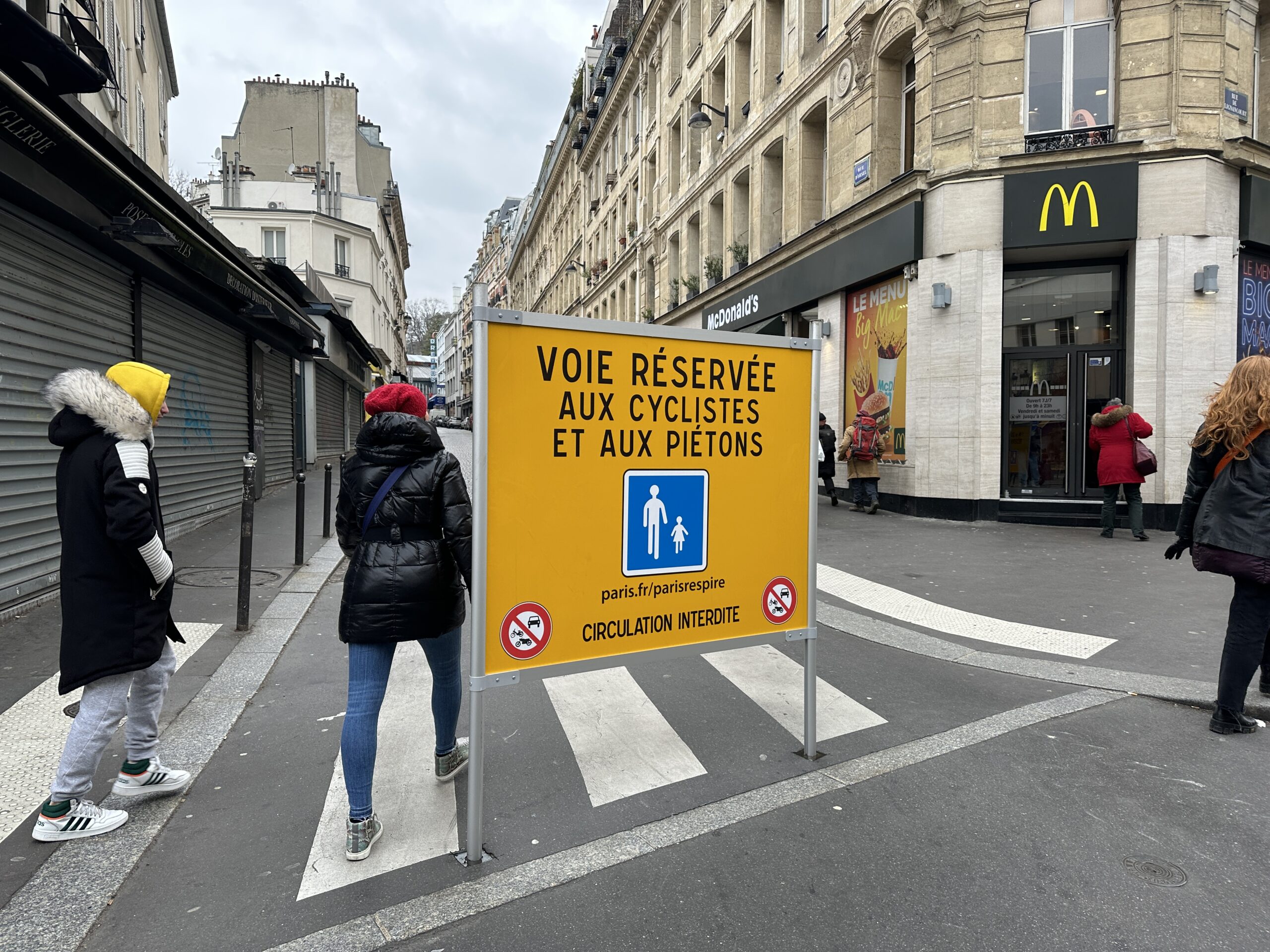
Every weekend, Paris shuts down some streets to car traffic for its “Paris respire” program — a great initiative!This photo demonstrates a little bit of the chaos that currently comes with getting around by bike or foot in Paris.
From a cycling perspective, this story has been difficult for me to figure out how to talk about. It wasn’t anyone’s fault, really — the person who’d parked their car in a designated spot next to the bike lane didn’t do anything wrong, and although Becker felt responsible because he’d lended me the bike, I assured him that of course he wasn’t to blame either. I’m inclined to fault myself for not paying close enough attention to the ground ahead of me, but while I probably could’ve done more to be aware of my surroundings, you can’t prepare for everything. The only way to prevent situations like this is to make sure bike infrastructure is as smooth as possible and designed to accommodate human error.
So, what does this saga say about Paris and its path to being 100% bikeable? Well, sadly, I didn’t get to go on the bike tour of the city after all, so I wasn’t able to get as deep of a look into the new infrastructure as I’d hoped to. But between my injury and my time watching how bike, pedestrian and car traffic plays out in the city (oftentimes pretty chaotically) I would say Paris certainly has some snags to overcome before it becomes the new Amsterdam or Copenhagen.
All hope is not lost, however.
In addition to the bike plan, I was impressed that Paris has a plan for cars à la Portlander Cathy Tuttle’s “Car Master Plan” framework. Hidalgo wants to ban most car traffic from the city center by 2024, making more room for people walking and biking. This is a really important part of creating a bike-friendly city that most transportation departments in the United States can’t bring themselves to approve for fear of retaliation.
Between plans like these, a rich ecosystem of advocates to hold the government accountable and a population of people who are clearly interested in biking (as well as rolling on scooters and rollerblades) I feel confident that Paris will fully transform into its best biking self. I think American advocates should pay a lot of attention to how the story in Paris plays out over the next few years.
That being said, I’ll have to reassess my risk aversion levels before committing to a trip back there. But that has to do with more than just bicycling.
Portions of two of the draft neighborhood profiles from the Office of Community and Civic Life.
I read a lot of BikePortland comments. Actually, I read all the comments, even the ones that Jonathan approves before I get to them. About 30,000 comments last year. (Yes, it probably does do something to your brain.)
The caliber of your comments is impressive. Sometimes a news post seems merely like a cue for the knowledgeable discussion that follows it.
Every so often, though, I push a comment through that I’m pretty sure is incorrect. We don’t have time to fact check comments, but sometimes curiosity gets the better of me and I might quickly try to find out, say, which neighborhood is really the most dense in the city (the Pearl), or to verify which neighborhood coalition represents the largest percentage of the city’s population (a tie between Southeast Uplift Neighborhood Program and East Portland Community Office at around 26% each).
Some of that simple factual information, “which is the fastest growing neighborhood in Portland?” can be surprisingly difficult to find.
That’s why I was excited to hear Michael Montoya, the interim director of Portland’s Office of Community and Civic Life, speak to my neighborhood association last week. His topic was Civic Life’s Portland Engagement Project (PEP).
Michael Montoya, Interim Director of the Office of Community and Civic Life
This year the PEP will release an information-rich, interactive map of neighborhood profiles made in collaboration with the Portland State University (PSU) Population Research Center.
Data from a number of sources will be aggregated: the 2020 census; the American Community Survey; Feeding America food insecurity data; CDC Social Vulnerability Index; the book Portlandness: A Cultural Atlas; and National Center for Health Statistics Life Expectancy Estimates.
This will be an invaluable resource for city employees, advocates, the public—anyone who values accuracy, even BikePortland commenters. The great thing is that all this information will be in one place—demographics for every neighborhood will be a click away. (And technocrats will appreciate the work that went into adjusting the data to neighborhood boundaries. For example, the federal government reports census data in census blocks, which don’t align with the neighborhoods. It’s a headache which the profiles make go away.)
Here is the preliminary profile of Cully. You can see that Cully is one of the most racially and ethnically diverse areas in town, and that 13% of it’s residents are “severely rent burdened.” A quick glance at the Grant Park neighborhood shows that it is one of the wealthiest in the city. What does your neighborhood look like? Check it out in the preliminary profiles of all 94 neighborhoods.
Montoya pointed out that the work on the Portland Engagement Project is being done in the context of “the herculean task” of charter reform, and that there is a “debate happening in the city right now around who should usher in these transitions.” Currently, city engagement with the public is not good, his office is grappling with what future engagement should look like.
Listening to him, it occurred to me that the public-facing charter reform transition is essentially a map reconciliation project.
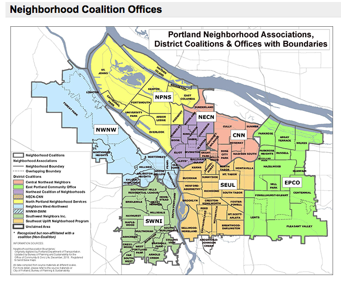
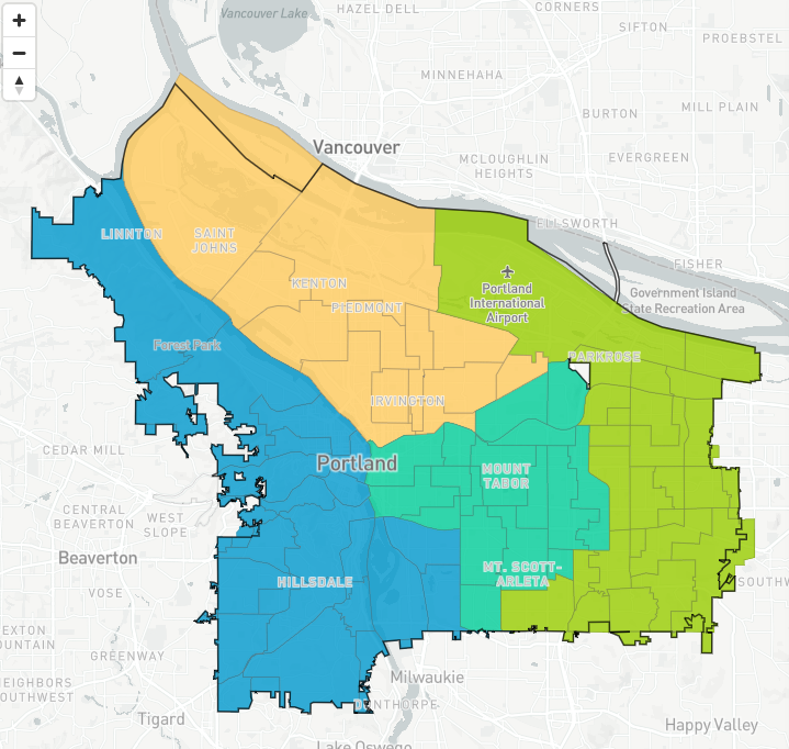
Portland groups its neighborhoods into seven coalitions. How will those seven neighborhood coalitions map onto charter reform’s four council districts? Will neighborhood coalitions be retired, with district offices absorbing the support work they provide for NAs?
BikePortland commenter Adam made this district map using the Districtr tool from MGGG.
For example, the charter transition will need to reconcile the neighborhood association (NA) structure with the new district structure. Portland groups its neighborhoods into seven coalitions. How will those seven neighborhood coalitions map onto charter reform’s four council districts? Will neighborhood coalitions be retired, with district offices absorbing the support work they provide for NAs?
This might not sound like anything but paper shuffling to those unfamiliar with the central role of NAs in the city’s engagement process, but it really is transformational. In a city without district representation, where each commissioner has been elected “at large” by the entire city for over 100 years, the neighborhood association structure was created to provide “channels of communication” between City officials and “the people of Portland.” At large voting and the neighborhood association structure have worked symbiotically for almost 50 years, they go hand and hand.
Montoya talked about the history of Portland’s NA framework. It came about at the end of the Vietnam War, and just after Watergate:
. . . the distrust was maybe even higher than it is now. Forming neighborhood-based associations was a way to influence and provide some check and balances on governments that were completely non-responsive.
But over the past few years NA primacy has been challenged—by former Commissioner Chloe Eudaly, by the director she appointed to the Office of Civic Life, Suk Rhee, and by culturally-specific organizations which would like a comparable seat at the table.
It has even been questioned by BikePortland readers, remember the Fremont and Alameda diverter controversy? There sure was a lot of confusion about what power a neighborhood association holds.
The reality is, today’s neighborhood association are mainly able to influence projects through their role as information conduit between neighborhoods and bureaus. They can pass on concerns and suggestions which PBOT will take into consideration. And that’s it. Fremont at Alameda now has its bike-friendly greenway protecting diverter, despite the initial neighborhood vote.
Portland and the country once again find themselves in an era characterized by mistrust of government and complaints about lack of representation. Our solution this time around has been to change how we vote and the way we are represented. What is still to be seen is what the working relationship between district city council offices, neighborhood associations and city bureaus will look like.
The Portland Engagement Project wants to hear from you and will be begin community listening sessions early this year. In the spring the City and PSU will host a summit to discuss public engagement practices, and in mid-2023 the City will host informational meetings to share the neighborhood profiles. Stay tuned. We need to make sure our voices are heard in the next era of civic engagement in Portland.
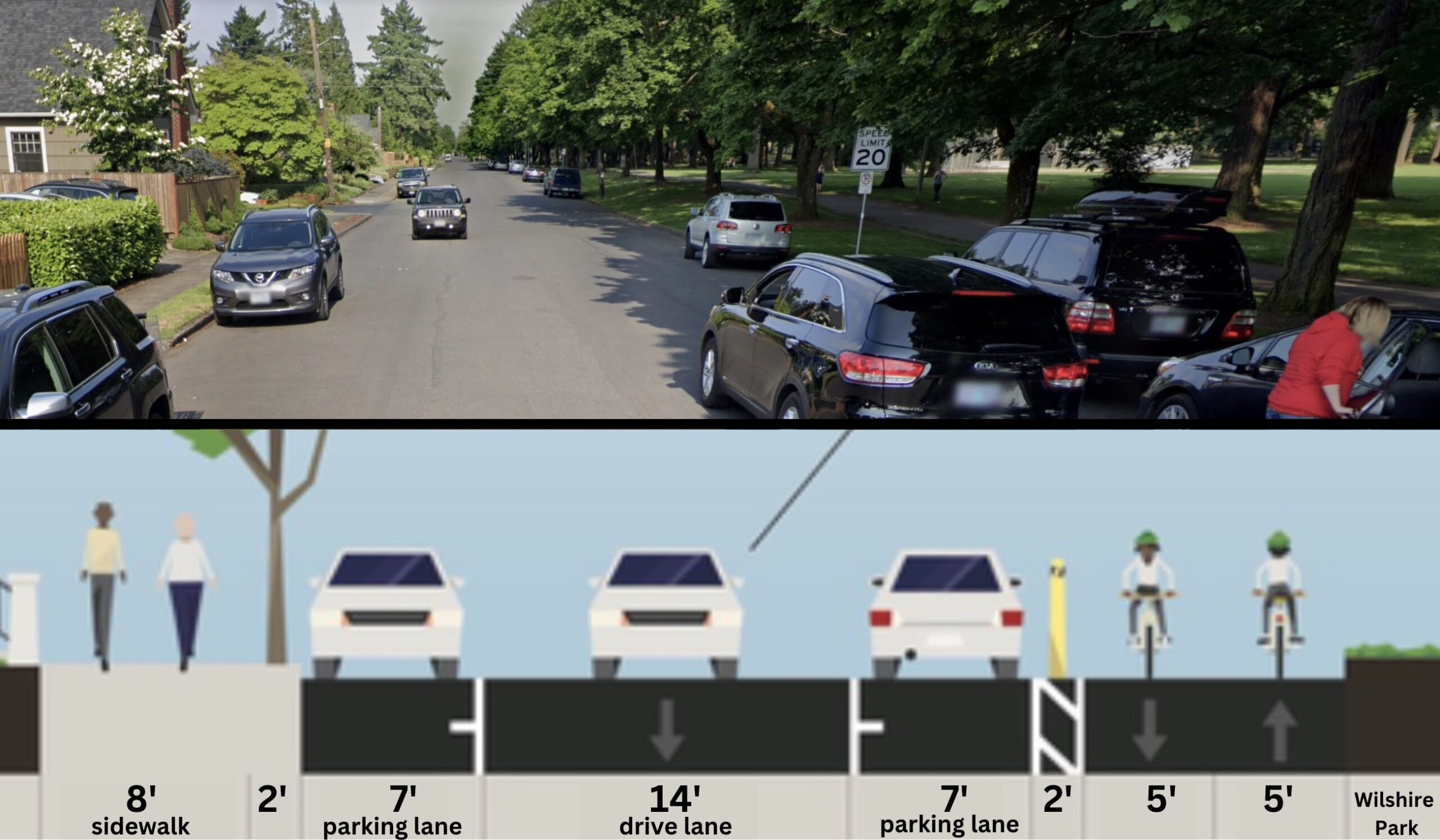
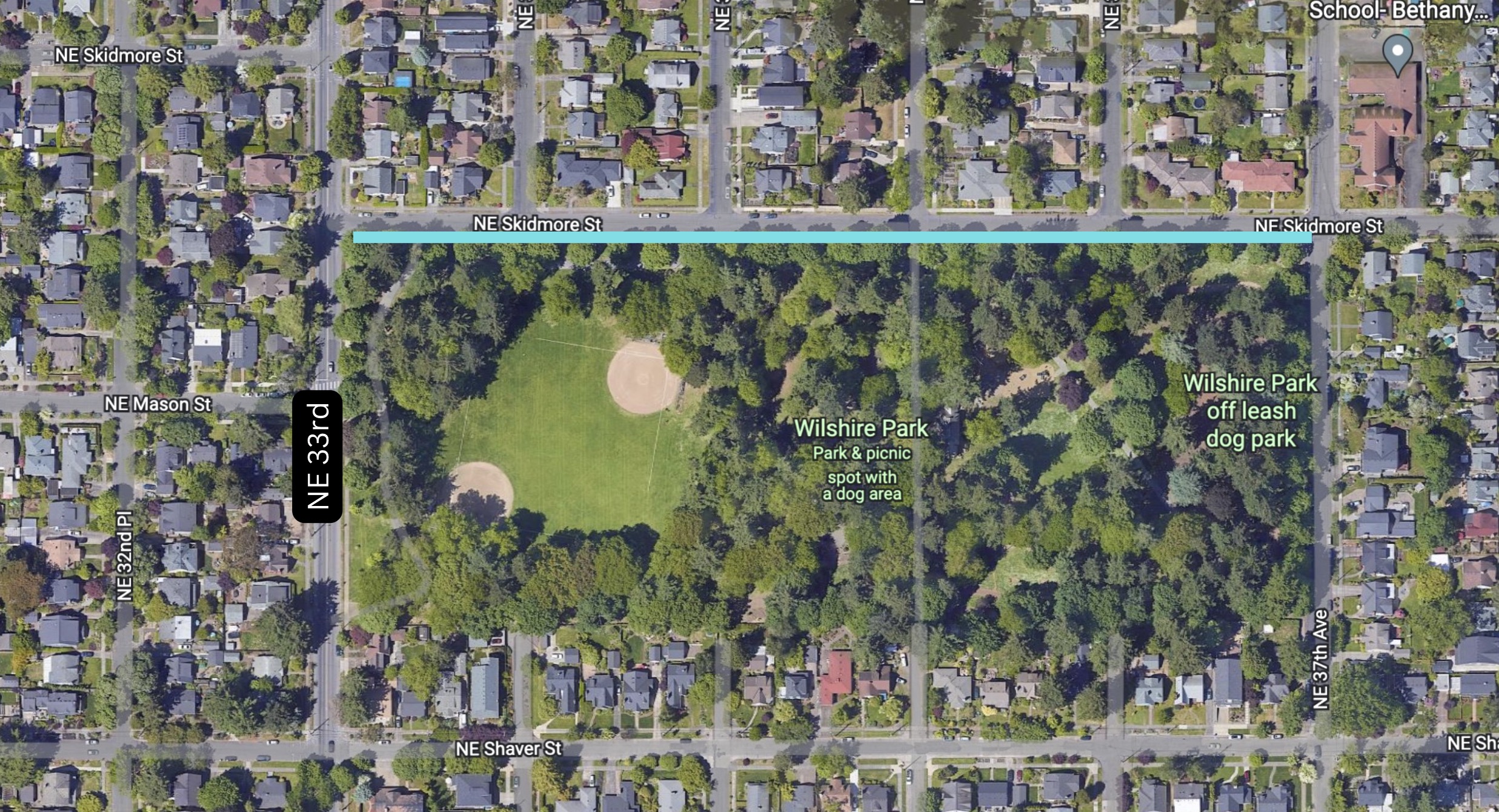
The City of Portland is putting final touches on a plan to build a new two-way protected bikeway on Northeast Skidmore from 33rd to 37th. This is the segment of Skidmore adjacent to Wilshire Park in the Beaumont-Wilshire Neighborhood.
(Map: BikePortland)
The goal of the project is to slow down car users and provide a safer space for bicycle users and people walking near the park. This stretch of Skidmore, which is classified as a “major city bikeway” in Portland planning documents, currently gives drivers 40-feet of space to operate, far more than is necessary or safe. A Portland Bureau of Transportation analysis showed that most people drive 27-28 mph, well over a safe and considerate speed next to a park — not to mention that the posted speed limit is 20 mph.
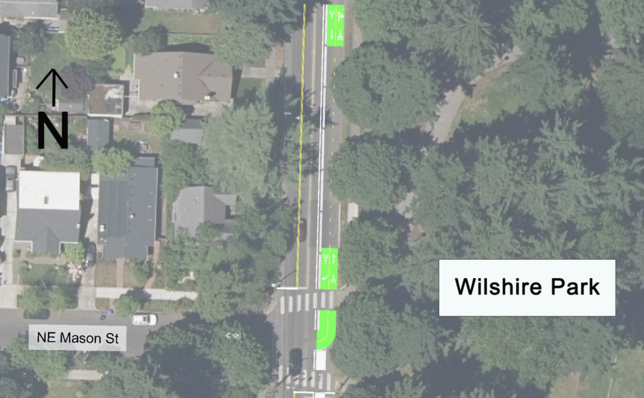
The PBOT design proposal calls for 14-feet of (two-way) driving space and another 14 feet for two, seven-foot parking lanes. The remaining 12 feet will be used for a two-way protected bike lane (curbside to the park) that has two, five-foot lanes and a two-foot buffer zone from parked cars. PBOT believes the narrower operating space for drivers will encourage them to slow down. The new carfree space adjacent to the park will create a new safety buffer for bicycle riders and other users.
This crossing on NE 33rd will be constructed soon to connect to planned bikeway on Skidmore.(Source: PBOT)
PBOT considered a more typical shared-street, neighborhood greenway treatment for Skidmore but there are too many drivers going too fast to do that without installing diversion to limit traffic from NE 33rd (a major neighborhood collector). A PBOT traffic diversion analysis showed that banning eastbound movements onto Skidmore from 33rd would lead to too much out-of-direction car traffic on other residential streets.
Speaking of how this fits into the larger neighborhood greenway is the problem of how westbound bicycle riders on Skidmore will transition into the two-way bike lane on the south side of the street. If you’re riding westbound you’d be on the north side of the street, so you’d have to cross over oncoming traffic to get into the bike lane. This sets up a conversation about either an enhanced crossing treatment or some sort of median traffic diverter at NE 36th or 37th to remove that threat of oncoming traffic.
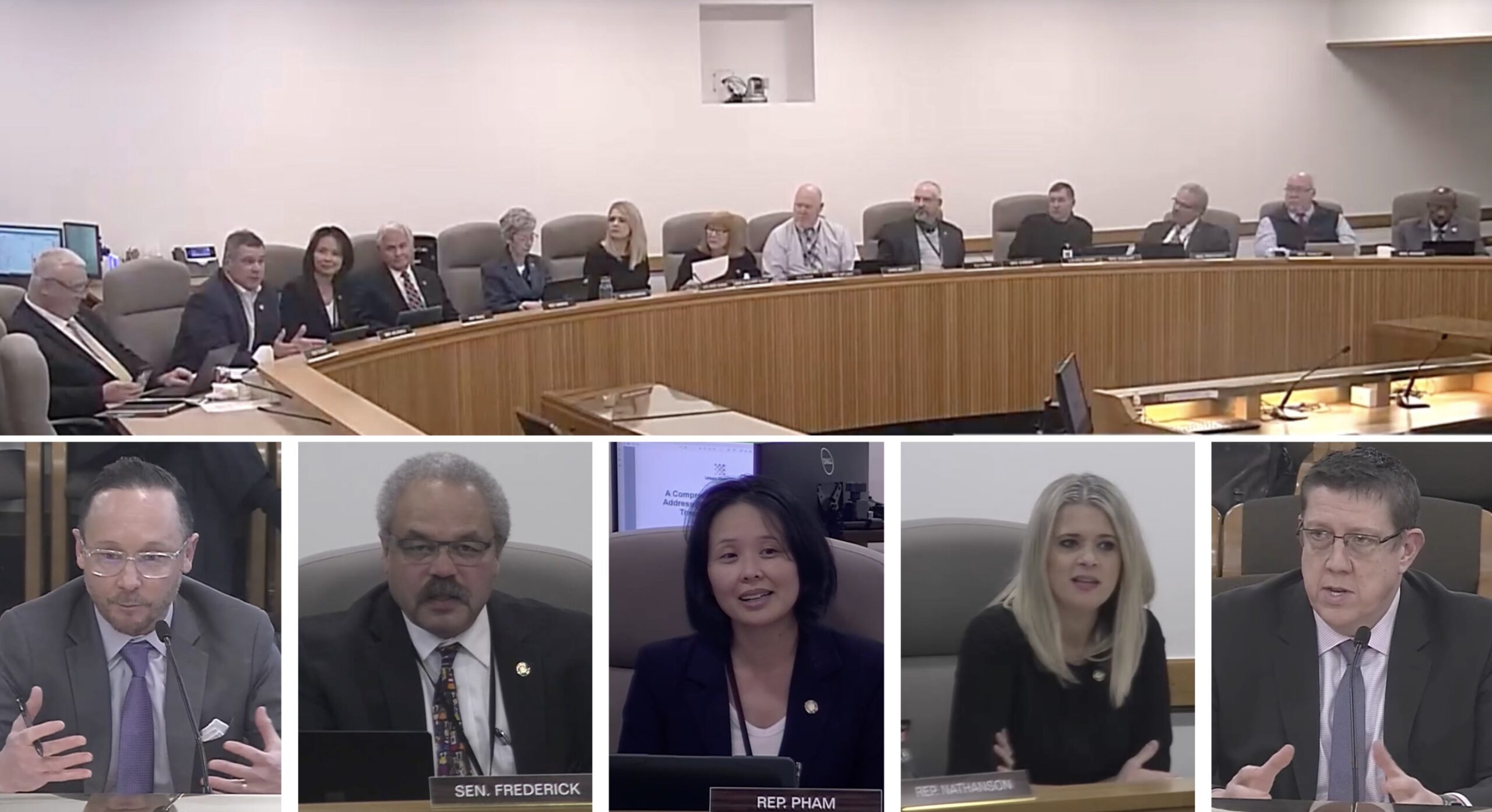
January 17th meeting of Joint Committee on Transportation. L to R: ODOT Urban Mobility Office Director Brendan Finn, Sen. Lew Frederick, Rep. Khanh Pham, Rep. Boshart-Davis, ODOT Director Kris Strickler.
“Why didn’t you look at public transit investments for congestion relief?”
– Khanh Pham, Oregon House
I used to think the I-5 freeway expansion projects at the Rose Quarter and the Interstate Bridge were the toughest things the Oregon Department of Transportation could ever try to pull off; but that was before I fully understood the massive headwinds they face on tolling. For ODOT, starting up a toll program will make trying to widen a freeway in Portland’s central city seem like a walk in the park.
Tolling is full of thorns matter how you try to hold it. Many people fear diverted traffic will exacerbate already dangerous and clogged surface streets, some are concerned a lack of options to driving will create captives to the fees, others don’t trust ODOT’s motives or their planned uses of the revenue, and some people simply just don’t like the idea of being charged more to drive. Behind each one of these serious detractions are upstart activist groups ready to pounce.
With the start of the 2023 legislative session last week, ODOT leaders now have another powerful slate of skeptics and scrutinizers: Oregon lawmakers. ODOT is facing hard questions and skepticism about tolls from both sides of the political aisle.
At the first two meetings of the Joint Committee on Transportation in the Oregon legislature last week we learned how key lawmakers feel and how high the stakes are for a program that hopes to begin charging tolls for driving trips for the first time ever by the end of next year.
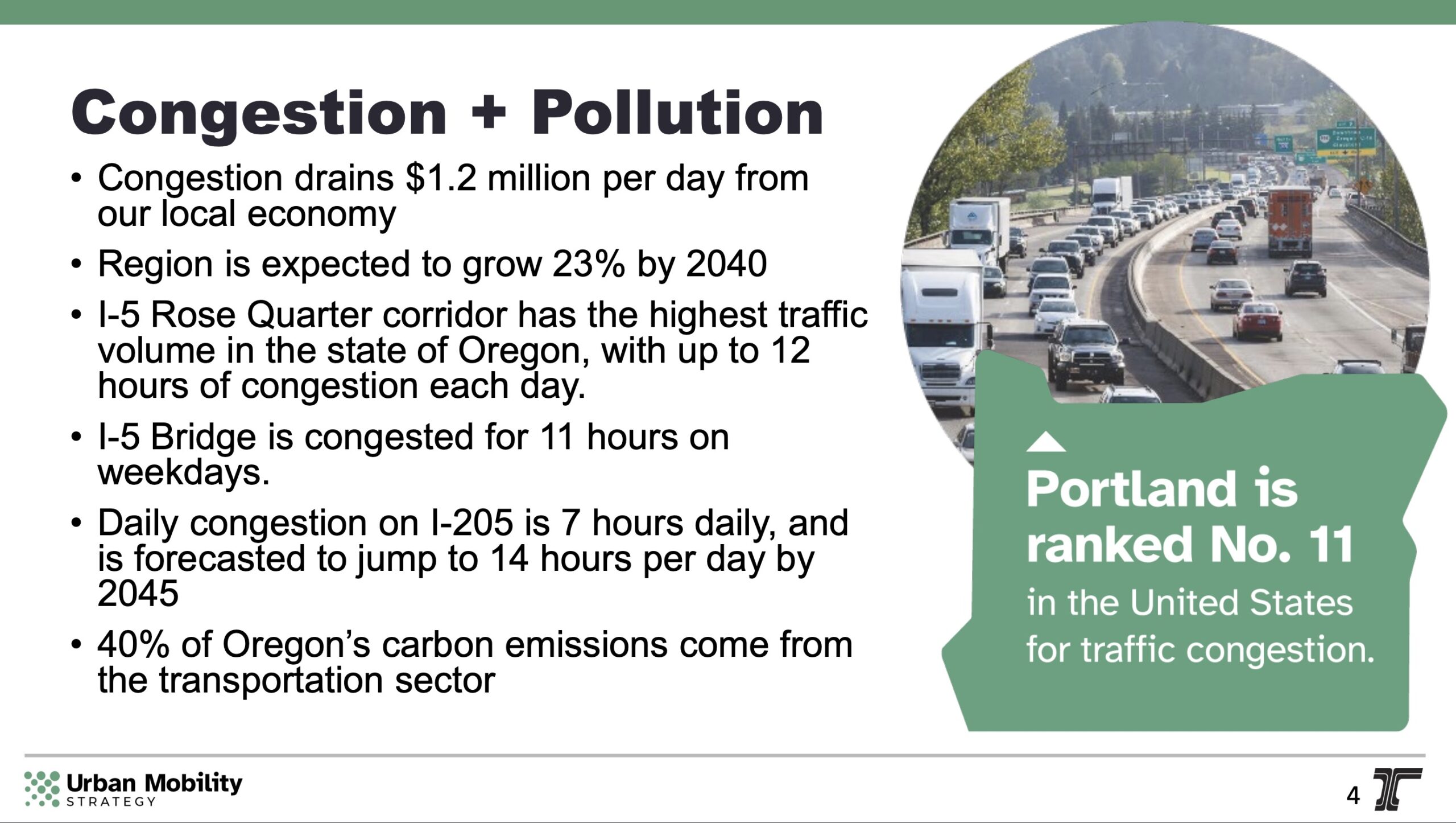
At their first meeting of the session on Tuesday, January 17th, the committee heard a presentation on ODOT’s toll program. As ODOT Urban Mobility Office Director Brendan Finn went through his slides, State Rep Khanh Pham asked him to stop on the one labeled, “Congestion + Pollution.”
ODOT slide shown at the meeting.
“I assume the assumption behind this is that tolling will help fund the freeway expansions which will reduce the congestion,” Rep. Pham said. “I’m thinking about what we could do to get people out of their cars by investing in public transit along those corridors. And what a billion dollars could do for that. Why didn’t you look at public transit investments for congestion relief?”
Finn replied that in addition to freeway expansion funding, the legislature set aside money for transit in the landmark House Bill 2017 package passed in 2017. He didn’t mention any dollar amounts, but that funding is based on a state payroll tax that has generated about $60 million per year for transit improvements statewide — a drop in the bucket compared to what the state spends on highway projects.
Then Co-Chair Rep. Susan McClain, one of the main supporters of HB 2017, interjected to back up ODOT. She added that the bill was “multimodal” because it “did something” for transit, Safe Routes to School, and so on. She’s right. It did “something.” But this framing overlooks the huge imbalance of spending and belies the fact that it was a “highway bill” with its vast majority spent on freeway and highway projects.
“I’ll be very kind to you on this — ODOT has not necessarily got the greatest amount of trust.”
– Lew Frederick, Oregon Senate
Senator Lew Frederick, who represents north Portland neighborhoods bisected by I-5, said his chief worry is diversion of freeway traffic onto streets like Sandy, Martin Luther King Jr. Blvd, and Broadway. “The concern is that the city is going to be asked to upgrade [those streets] without any additional resources… Where are you in terms of talking with folks about how that diversion strategy will be paid for?” he asked.
When Brendan Finn from the Urban Mobility Office said ODOT is working to model these impacts with the City of Portland and that the state will ultimately pay for those mitigation projects, Sen. Frederick replied, “I appreciate that. But I’ve got to tell you some of the people that I’ve heard concerned about it are the folks in those very cities and city governments who are saying, ‘We don’t know what’s going on with this exactly. We’ve been given vague assurances.'”
“And they,” Frederick continued. “And I’ll be very kind to you on this — ODOT has not necessarily got the greatest amount of trust and the idea that you’re going to do something about it, and that [cities] will be involved is not necessarily enough. I think you need to be much more direct and specific about how you’re handling this situation.”
(Later in the meeting Sen. Brian Boquist underscored in stark terms the public perception problem ODOT faces: “You’ve got a communications problem you’ve got to fix. It’s just that simple. You’ve got to fix it if you want to go forward.”)
At that point Director Strickler jumped in. Strickler has already begun to manage expectations and set his own narrative about diversion and who will be responsible for it. “It’s important that we identify what the true impact of the toll is,” he said at one point in the meeting. “As opposed to just kind of a desired wish list associated with all the other things that we have to do in an area.” He told Sen. Frederick that we have diversion from traffic on the freeway now and it’s difficult to understand what exactly causes it. Regardless of its source, Strickler assured the senator that the NEPA process for the toll program will force ODOT to pay for any negative impacts tolling is expected to have on surrounding streets.
“As we go through that process, I am asking for a little bit of a trust.”
– Kris Strickler, ODOT
Strickler also said that ODOT doesn’t know what the diversion impacts might be because they haven’t completed an analysis of it yet. “I’ll be honest with you, we don’t have firm answers to say, ‘These 12 intersections will be mitigated,’ because we’re still trying to evaluate the impacts of each of those. But as we go through that process, I am asking for a little bit of a trust.”
Sen. Frederick still seemed unsatisfied. “Here’s the issue,” he said, sharply. “You don’t let people know soon enough. You don’t let people know often enough… in order to try to at least begin to break through that trust issue because people make up their own myths if they if they’re not given enough information.”
House Rep Khanh Pham added to Frederick’s points by asking ODOT for a specific estimate of total revenues each city will receive to mitigate toll program impacts to low-income households, public transit providers, and local governments to pay for street upgrades.
ODOT Director Strickler told Rep. Pham, “That’s actually not the way that the process is working… We don’t have those numbers yet.” Strickler said the FHWA (via the NEPA process) will tell ODOT what (if any) the negative impacts are and then they will be directed to fund mitigation of those impacts. But he also warned that all tolling revenue will be part of the State Highway Fund so it will come with strings attached (as in, it cannot be used to fund transit or other “non-highway” projects as per Oregon’s constitution).
“You’re also saying there’s restrictions to what you can do, so some of [those mitigations] would be unfunded…”
Unfortunately this exchange between Director Strickler and Rep. Pham was cut short because Rep. McLain interjected for a second time. “Okay, so this is a really important area. And it again, is is not done, the conversation is continuing on,” she said.
After getting grilled from Democrats Frederick and Pham, next up was Republic Rep. Shelly Boshart Davis. She thinks tolls are social engineering. “I hear a lot about changing behavior and getting people out of cars. You say we’re giving people options, I hear we’re taking away choices,” she said. “I think that is cause for concern. I think that that needs to be recognized that we’re making choices for other people… my constituents hate it when the state tells them what to do,” Boshart-Davis continued, perhaps not realizing that the current system that allows driving to remain so cheap and convenient also takes away choices of many people.
Keep in mind, all of this happened at just the first Joint Transportation Committee meeting of the session! And just two days later, ODOT was grilled again about their toll plans and how they will impact low-income Oregonians.
It’s going to be a very bumpy ride for ODOT. Wait until you learn how leveraged they are because of project cost increases and their desperate need for funding several freeway megaprojects they are determined to get done no matter the cost. Stay tuned!
Somewhere in east Portland. (Photo: Jonathan Maus/BikePortland)
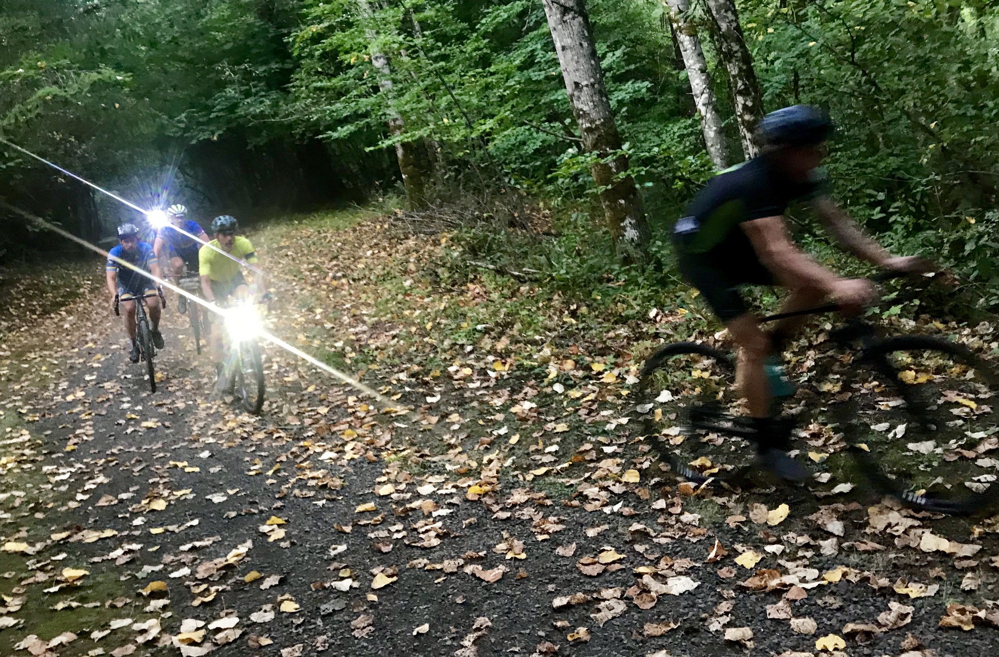
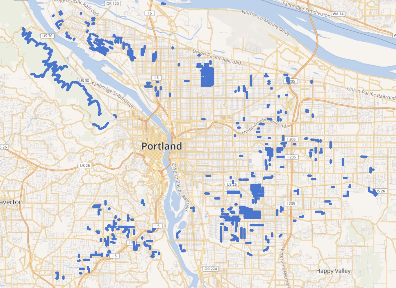
A Portlander has taken his love of riding on unpaved roads to a new level with the creation of a website called Gravelland. It’s the latest in our city’s long-running love affair with taking road bikes off-road.
Andrew Osborn is the man behind GravellandPDX.com, a site profiled by VeloNews last week that’s devoted to mapping every section of rideable gravel in the Portland area. It’s an excellent resource for anyone who wants to spice up their next ride. Osborn is running the site as a nonprofit that’s, “working to improve knowledge of riding opportunities in our city, help more people learn about the fun of riding gravel, and network the gravel-riding community.”
So far he’s mapped 391 sections of unpaved roads and trails. The site also has 12 curated routes to help you get started. Osborn’s work builds off local interest in gravel and adventure riding that’s been building for well over a decade now — from the legend of Otto Miller Road and the “Bullshit 100” ride, to VeloDirt and Our Mother the Mountain.
Route thumbnails.Blue are sections of gravel roads/trails.Screenshots from GravellandPDX.com
What sets Gravelland apart is how easy it makes urban explorations, and how it encourages you to think differently when you plot out your next ride. Too many people tend to ride past our big urban parks, rather than ride through them. And if you haven’t explored the dirt treats along the Willamette Bluff or the East Buttes, now you have one less excuse. Just grab one of the routes or pick an unpaved section, plug it into your GPS unit or phone, and set off.
The routes are mostly paved with sections of gravel and dirt here and there. Most of them can be ridden on standard road bikes (if you’re careful to not flat).
Osborn told VeloNews a big reason for this project is to get more beginners into mixed terrain riding and to make gravel more accessible to more people even if they don’t have a lot of time or a ton of high-end gear.
Before I share our news roundup, I want to thank all of our subscribers, advertisers, and supporters. BikePortland exists because businesses buy advertising and our readers step up with financial contributions and monthly subscription payments. If you are a regular reader — or if you understand the vital role community journalism plays in a healthy society — please join the effort to keep this trusted local news source alive. Become a supporter today!
And with that, here are the most notable stories our writers and readers have come across in the past seven days…
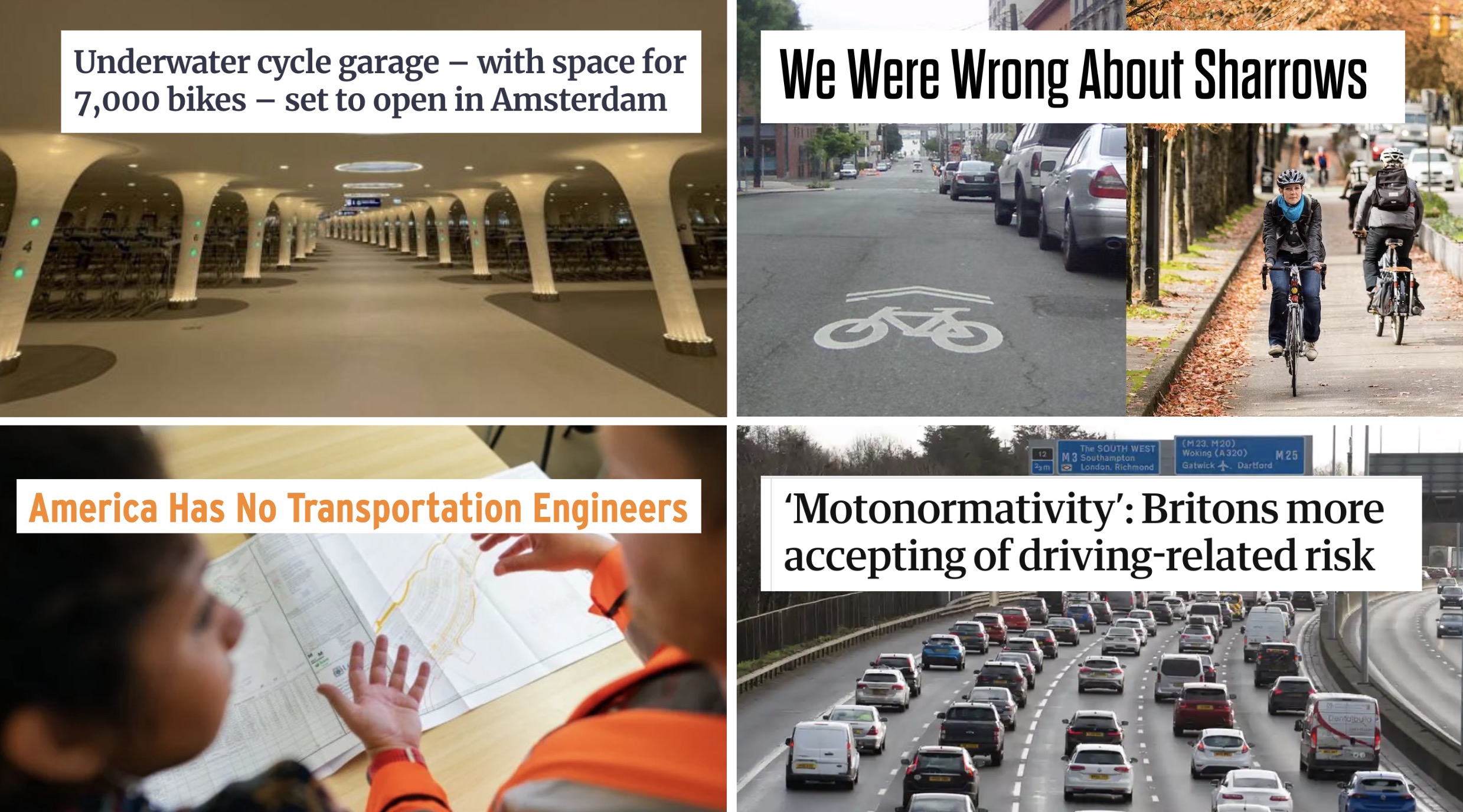
A.k.a. “car brain”: Authors of a new paper that looks into the psychology of car drivers have coined the term “motonormativity” to explain how social norms and unconscious bias make too many people unable/unwilling to address road deaths and crashes. (The Guardian)
Nail in sharrow’s coffin?: A veteran bike advocate admits that pushing sharrows back in the 1990s was a very bad idea because they don’t work (except for wayfinding like Portland uses them for) and they give empty credit to policymakers who install them. (People For Bikes)
Diversion works: A new study from London shows that neighborhood streets with diverters reduce car traffic but do not lead to a commensurate increase in nearby larger arterial roads. (Forbes)
From Stumptown to Gravelland: A Portlander has created a website full of routes that let you ride to popular local destinations “the gravel way.” (VeloNews)
Radical vs practical: A major debate of our time is how fast we should expect society to change in response to major crises like climate change. In transportation, that debate often plays out how one sees the role of EV-cars as a solution. (Boston Globe)
E-bike subsidy: Nashville, TN is the latest city to consider a cash-back program for people who buy e-bikes. Using federal COVID relief dollars, the program would offer rebates ranging from $300 to $1,400. (WPLN)
Amsterdam’s latest: One of the world’s cycling epicenters is just messing with us by building a bike parking station with 7,000 stalls that will be completely underwater. (Road.cc)
The engineering problem: Turns out one of the big problems in fixing America’s roads lies in the fact that most transportation engineers are ill-equipped for the job. (Next City)
Avoid these five states: Statistics reveal that the states of Texas, California, Florida, Georgia and North Caroline accounted for nearly 40% of fatal traffic crashes nationwide in 2022. (Yahoo)