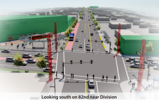
The Oregon Department of Transportation says it needs to preserve five auto lanes on 82nd so the dramatically increased number of cars that Metro expects on the street by the year 2035 will have somewhere to sit during rush hour.
Should a new high-capacity express bus line through Southeast Portland run on the most important street in Southeast Portland, or 30 blocks away?
The question seems odd. But as Metro and TriMet ask the region whether the new “bus rapid transit” line they’re planning should run on half a mile of 82nd Avenue, here’s part of the subtext: In order to get permission to run the bus line on 82nd Avenue, project planners have agreed not to aspire to do anything for biking, walking or transit on 82nd that might significantly reduce the number or capacity of cars there.
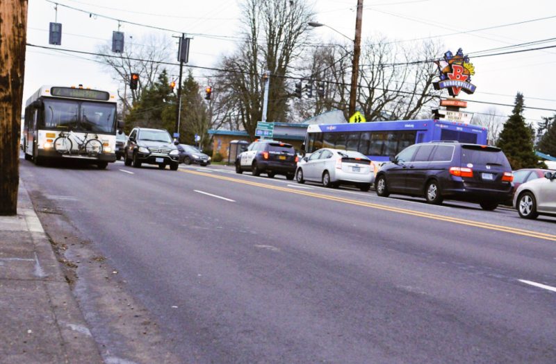
In fact, even if the highest-quality version of the project currently being considered were built, buses there are projected to travel slightly slower in 2035 than they do now. Rush-hour travel times would rise to about four to five minutes for the half-mile stretch, up from about three minutes during the afternoon peak today.
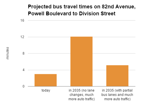
Among other factors, this is because the Oregon Department of Transportation says it needs to preserve five auto lanes on 82nd so the dramatically increased number of cars that Metro expects on the street by the year 2035 will have somewhere to sit during rush hour.
In this scenario, the major time benefits of the project to bus travel on 82nd Avenue would materialize only if the street becomes overwhelmingly jammed with cars over the next 20 years — which is what the official models currently expect to happen, despite the city and county’s official goals of cutting local auto traffic in half over the next 15 years.
Here’s why the project might be a good idea anyway: If it is not built, and if Portland does indeed fail to meet its goal of halving auto trips by 2030, then bus travel times on this stretch of 82nd will triple.
That’s because the hundreds of people in 82nd Avenue’s crowded buses would be stuck behind hundreds of single-occupancy cars — just like all the people in cars would be.
TriMet has 21 months to find funding and consensus
It’s important to note that this range of possibilities is not written in stone. Instead, this is a rare look into the pre-planning that goes on behind the scenes of every big transit project.
With this project, a quirk in the public process is opening a bit of that pre-planning to more public debate than usual.
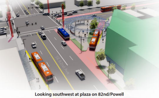
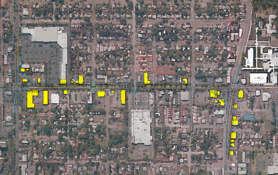
At issue right now is a small portion of the 18-mile project: the 1/2 mile between Powell Boulevard and Division Street in mid-Southeast Portland.
The Powell-Division Transit and Development Project is a proposal from transit agency TriMet and regional government Metro to spend something like $200 million, half of it from the federal Small Starts grant program and the other half from undetermined local sources, to create an express line of big bending buses featuring flashy new stations with raised platforms and other features that make traveling by bus feel more like traveling by MAX.
Unlike MAX, however, the buses will mostly not get lanes of their own. Instead they’re expected to get, at most, a series of chances to jump ahead of cars at stoplights. To support this, some blocks would get bus-only turn lanes and others would have lanes that would at least theoretically ban cars that are not preparing to turn right.
The full route would run between downtown Portland and downtown Gresham. It’d probably start on the south Transit Mall, cross Tilikum Crossing and join Powell through inner Southeast Portland. Between Powell and Division, the route will have to jog northward. That’d happen either at 50th Avenue, 52nd Avenue or 82nd Avenue.
Of those three, the likeliest prospect is 82nd Avenue, a state-run five-lane highway that doubles as a main street for much of Southeast Portland. It already carries one of TriMet’s most-ridden bus lines, the 72; the new express bus line might also run on that stretch.
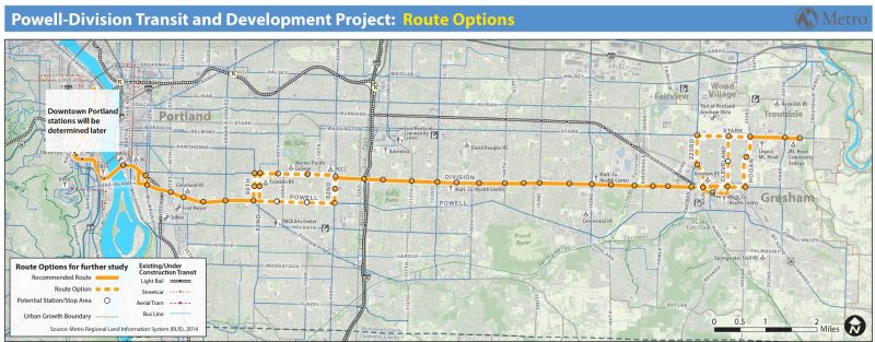
(Map: Metro)
TriMet started applying for federal funds last May. It has until Oct. 2, 2017, to come up with a detailed plan for the route and a general sketch of how to pay for everything, including the new buses, stations, road work and all the associated planning efforts.
On March 28, the project’s steering committee is expected to choose a final route, including the decision of whether to run the big buses on 82nd. From there it’ll go to Metro, to the cities of Portland and Gresham and to other relevant agencies. If all goes well for the project, it’d open in September 2020.
For project managers, this is the moment they’re hoping to get buy-in from people who care about 82nd Avenue.
“There are a lot of attractions there; it works for the community,” Metro planner Elizabeth Mros-O’Hara said Jan. 8. “But they need to see what it’s going to look like enough to understand what the potential impacts might be.”
‘Every little bit counts for transit’
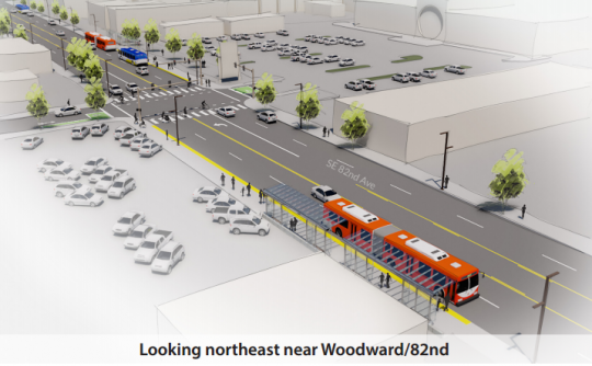
Though they won’t get full lanes of their own on 82nd, the new buses would use digital communications with stoplights on the route to get traffic signal priority.
“It’ll say ‘Hey I’m coming! Stay green,’ or it’ll say ‘Hey I’m coming! Shorten that red and go green,'” said James McGrath, a project consultant for CH2M. “We’re using station placement to garner little advantages. … Every little bit counts for transit.”
McGrath is hoping that the buses, each of which would have room for something like 86 people, will be allowed to load and unload passengers right in their lane rather than pulling over and waiting for a gap between cars to get moving again. But McGrath said that’ll only be “possible” if having buses stopped in the right-hand lane isn’t expected to greatly slow auto traffic.
“If we’re allowed, if the traffic modeling shows that it’s possible, the bus will stay in the travel lane as opposed to pull out,” McGrath said.
On their approach to busy intersections, buses would get either a short left-turn lane or a right-turn lane that can also be used by cars turning right into a driveway.
And at the corner of 82nd and Division, the new buses might get a new diagonal stretch of road to skip the stoplight completely.
All of that together, project planners said, adds up to quite a bit of travel time savings for people in buses — almost as much time as dedicated lanes would save, they said. But the planners couldn’t say precisely what difference dedicated lanes would make, because the project has not bothered to calculate them. That’s how far off the table dedicated bus lanes are.
TriMet has also not yet estimated what the travel times will be in the year 2020, when the project first opens.
At some intersections, McGrath said, the stoplight changes might add up to travel time savings for people driving.
Because so little road work is anticipated, the whole thing comes out to quite a bargain compared to a new transit line that would have new dedicated space. TriMet’s Orange MAX Line that opened last year cost about $200 million per mile. The entire 18-mile Powell-Division project, by contrast, is aiming for $200 million total, half of it from local money that has yet to be identified.
For comparison’s sake, a bike lane protected by concrete or hardened plastic bumps costs about $50,000 per mile, but only if it can be put on road space currently used for something else.
‘We have to try to make things better for everybody’
I asked the four public transit planners assembled at the Jan. 8 meeting what the problem would be with slowing auto traffic if it were to significantly improve public transit.
After a moment Jeff Owen, TriMet’s active transportation coordinator, answered.
“We have to consider all modes and all users.”
– Don Hamilton, ODOT on why the agency won’t consider full bus lanes on 82nd
“Our partners,” he said, referring to the state and city governments. “We can’t really do that much alone.”
The city didn’t have anyone at the meeting, but ODOT spokesman Don Hamilton was there. As the other people in the room waited for him to say something, he answered my question too.
“Because we look out for all users of the corridor,” he said. “We have to try to make things better for everybody.”
Even if that’s in the service of using devices that are destroying our planet and killing 30,000 Americans a year, I asked?
Those are larger problems beyond ODOT’s control, Hamilton replied.
Later, I asked Hamilton to clarify if “make things better for everybody” literally meant that ODOT couldn’t support any transit project that would increase auto travel times.
Hamilton said he hadn’t meant that.
“I meant that more generically, that we have to consider all modes and all users,” he said.
No bike lanes without more money, TriMet says
OK, so what about bikes?
Last month, Jonathan wrote about the unexpectedly tense meeting between the project staff and the Portland Bicycle Advisory Committee at which TriMet staffers tried to talk down the possibility of continuous bike lanes on this stretch of 82nd.
Officially, the project is considering what it describes as the “high-impact” scenario of putting continuous bike lanes on 82nd. There’s also a possibility that some compromises could be found between that scenario and the “minimum impact” one that has no bike lanes — a short bike lane might be added to improve a crossing or connect to a particular bus station, for example.
But after looking at this in detail and asking quite a few questions, I have to agree that it would be difficult for this project to include bike lanes. Here’s why.
“I think the reality is a lot of this area would have parallel bikeways.”
— TriMet active transportation planner Jeff Owen on bike access to 82nd
82nd Avenue currently has two auto lanes in each direction plus a center turn lane. Installing bike lanes as part of this project would require, more or less, one of these three things:
1) You could widen the roadway, which would force TriMet to buy and demolish various buildings. Much of the property facing 82nd is currently parking lot, but not all. If the acquisition were split evenly on both sides of the roadway (which would preserve the existing trees on both sides) this would require some level of demolition or relocation of buildings on properties. Metro and TriMet haven’t done any research into what this would cost except to say that they don’t think the project can afford it at its current scale.
2) You could have auto and bus traffic share a single lane in each direction with a center turn lane. This would make 82nd Avenue much easier to cross and open up room for wider sidewalks, but would greatly increase bus travel times.
3) You could remove the center turn lane and use a curb to block left turns. McGrath said this would require new space for U-turns at Division and Powell and probably also at Woodward, where Asian superstore Fubonn anchors a major strip mall. He said that tapering the lanes to allow those U-turns wouldn’t end up saving much space along the corridor; you’d still end up buying a lot of land and demolishing a lot of buildings.
Since none of these options have much appeal without significantly more money than the project expects to have, the project staff is convinced that the next best alternative is for the city to create a new neighborhood greenway on 79th and then make it easy to get over to 82nd here and there.
“I think the reality is a lot of this area would have parallel bikeways,” said Owen.
It’s possible to argue that half a mile of bike lanes on 82nd Avenue isn’t a big deal, since the rest of the street will still lack them. But there’s another side to that coin: If the project is built without bike lanes, will people spend the next 50 years saying there is no point putting bike lanes on 82nd at all, because this crucial segment won’t have them?
One possible answer to this is that as these properties gradually redevelop along 82nd, the City of Portland could require each developer to set aside enough space beside the road for both a sidewalk and a new bike lane. That would take decades, but it might work. The city currently has no such requirement.
As I’ve put this story together I’ve talked to quite a few people about the Powell-Divison project, and most people seem to have genuinely mixed feelings about it. We’ll cover those more as the project moves forward — and in the coming days we’ll also have a piece looking closer at plans for the 70s Bikeway that’s proposed on 79th Avenue.
— Michael Andersen, (503) 333-7824 – michael@bikeportland.org
BikePortland can’t survive without paid subscribers. Please sign up today.
Corrections: An earlier version of this post misstated the date of a meeting between BikePortland and various project officials. It was Jan. 8. It also misstated the passenger capacity of the bending buses (it’s 86) and the west terminus of the new line (probably the north transit mall, not the south transit mall).



Thanks for reading.
BikePortland has served this community with independent community journalism since 2005. We rely on subscriptions from readers like you to survive. Your financial support is vital in keeping this valuable resource alive and well.
Please subscribe today to strengthen and expand our work.
By using “preserving auto capacity” as a metric of success, this project is setting itself up for failure. Not having dedicated bus lanes on Powell and 82nd should be considered a non-starter for a project with “Rapid” in its name. It’s also startling that Metro is still using the tired old “car traffic will increase over time, always and forever” fallacy that plagues state DOTs.
We need to start purposefully designing decreased car capacity into our cities if we want to have any hope of reducing traffic violence and mitigating global warming. Instead, we’re getting another status-quo freebie to drivers. We can do much better.
You’re 100% right. People will use whatever mode of transportation is fastest and most convenient. If we reduce auto capacity, but INCREASE public transportation capacity, people will naturally switch modes.
This is a personal anecdote, so take it for what it’s worth. I lived on the north side of Chicago and worked downtown for years. I commuted via bike or took the El 99% of the time. I knew the week between Christmas and New Year’s traffic was virtually non-existent, so I drove. It took me 20 minutes to get to work via car that week, compared to ~45 minutes the rest of the year.
Oh hey, another Chicago ex-pat! I did the same thing. I grew up in the suburbs and drove everywhere, When I moved to the Lake View neighborhood in Chicago, driving became such a hassle, that I started biking and taking the train everywhere.
It’s counter-intuitive to a state DOT planner, but making driving harder (by giving other modes the space they deserve) actually increases capacity for people. Though, when they only consider the amount of cars, to them, it’s a decrease.
Sorry, but this is only true to a certain extent. There are a lot of other contributing factors that play into whether people take the bus or drive, not just time.
It would be like an effort to address institutional racism that has “preserving white privilege” as a metric of success.
If you plan cities for cars and traffic, you get cars and traffic. If you plan for people and places, you get people and places.
Zero Vision.
‘Every little bit counts for transit’
“You’ll eat the scraps the SOVs leave behind, and you’ll be grateful for it”
Transit needs every little bit, but private automobiles get the largest possible chunk by default.
inaction
82nd is a $h!t Show for a bicyclist, I would never ride that street. Just take the 205 trail or many other North/South side street options.
Glad I am not in planning, thankless compromises on everything you do. No matter what decision is made, it is the wrong one. Good luck planners!
The sidewalks aren’t too terrible until you get south of Woodstock (who said there isn’t singletrack in Portland proper?). However, I usually only do that for a block or two, since I know the side streets to take to get to my destinations on 82nd.
Still haven’t figured out why this is so difficult for ODOT and Trimet. Reroute the bus line to 52nd for faster service (Franklin HS access), and get rid of all left turns along 82 except for the major intersections. Ta-da you now have faster bus service and room for bicycles on 82nd.
Though honestly, I’m just happy my hood is getting this kind of attention, just about anything is a dramatic improvement than what sits on that stretch of the street right now. Though I just heard we’re getting a strip mall (despite the desire of the neighborhoods for mixed use) on the NE corner of Division and 82nd where the Hung Far Lows II now sits, fenced in – so much for the Jade district.
The irony of transportation planners who don’t have the ability to see two years into the future attempting to plan twenty years into the future (and failing) is too much to bear on a weekday morning.
Well put.
“the buses will mostly not get lanes of their own”
This kills the BRT line.
The Transportation and Land use committee of SE Uplift on Monday did an advisory vote. The full board will hopefully take up the motion on Feb 1. We advised the full board to endorse the middle-build option that requires only four building acquisitions. This is the preferred option by the Jade district leaders, the local neighborhoods and business community. We had a quorum with a vote of 11 to 0, one abstention.
If this city thought the racial politics of the Williams Safety Project was difficult, try using eminent domain to remake the center of the Jade District, without their support. Just imagine if the “bike lobby” forced “gentrification” on “another minority.” Cost may be the main factor, but really our local history in Albina tanked this concept from the beginning.
We need to make sure the parallel segments, which I know a little about, have ROBUST crossings, bike corrals and KIOSKS so everyone knows from the greenway where they need to turn and park.
Terry D-M, your scenario about how the “bike lobby” would be perceived holds harmless the worst actor in this whole bad film… cars and the people who enable there continued abuse.
If we did as much to keep cars off our streets as we do everything else, we wouldn’t need to demolish any buildings.
I was at the Bike Advisory Committee meeting when Metro presented about this… They clearly don’t want to do anything bold and they are using the “but we can’t destroy buildings!” thing as a very good excuse to not make dedicated bike or bus lanes.
Not saying I have all the answers here… but again, we are planning a transportation project by putting cars at the top of the pyramid, which is essentially illegal in our region from a policy perspective (if you look at adopted plans from PBOT and Metro).
The culture at ODOT is holding progress hostage. Again. It’s maddening.
Well, someone needs to consider the historic preservation of 60’s-era strip malls and parking lots… Sheesh.
The buildings up for acquisition are not the strip malls, which are far enough back to avoid the wrecking ball. The buildings they are talking about are the oldest, most walking-friendly, and have the most affordable rent. The little walkable streetscape that is present on 82nd would be gone, along with community serving businesses.
The real frustrating thing is what Jonathan brought up – that the conversation was “tear down buildings or get nothing” rather than “tear down buildings or remove travel lanes.”
Can you imagine losing this historical touchstone in favor of big-box mixed use developments in the style of lower Division? The horror.
I disagree that we are putting “cars at the top of the Pyramid.” What we are doing is placing cultural sensitively into the design for the local population. If this was a multi-million redesign of the entire 82nd corridor I would be all for dedicated cycle space. If it is a we WILL give you this because WE know what is good for you…..
Infrastructure has social consequences. Engineers did not take that into account when they built the Freeway system, so we go suburban sprawl and gated communities. This project I have gone to at least a DOZEN outreach meetings, process talks and feedback sessions over the past three years. They are really trying NOT to replicate Albina. If as a community we would have proven first that we can prevent displacement of an established ethnic minority neighborhood in an infrastructure project, then it would be different. But Portland, the whitest of all the major cities, has not proven itself to be ethnically sensitive.
Once automated cars take over and ADT drops in Urban centers, than we SHOULD put 82nd on a whole diet. Or if we build parallel connectivity for safe collectors in the 70’s and 92nd across the gulch, but this one section in a vacuum would create more distrust between the local communities and the regional governing system than is already there.
That would make ANY future project that much harder.
That will not happen for 30 years.
Then we need to get our acts together and start building real infrastructure projects as a society. We do everything on a shoestring budget. This is the wrong fight right now.
Jonathan, I think you’re missing a key point though.
What would cyclists actually get out of that (esp. if it involves all those issues and ill will that Terry mentioned)?
They would get an orphaned 1/2 mile strip of 82nd, that almost all people I’ve heard at 82nd meetings (including many cyclists (myself included)) don’t really want.
Of all the bike infrastructure to fight for in Portland, this one has to be REALLY far down the list.
So the “Jade District” folks apparently do not ride transit? Why do you think that they don’t value fast transit connections to their district?
I think Terry is referring specifically to the question of bike lanes on 82nd, which would probably require property acquisition (though Paikiala offers some interesting alternatives to that).
As you note, most of this article is about the fact that TriMet isn’t considering dedicated bus lanes for its “bus rapid transit” project. My impression is that Jade District leaders definitely care about transit but are also understandably uneasy about any changes to the street where they do business. However, I haven’t talked to any directly.
Of course, in the absence of this project or a better one, we are already on course for a HUGE change to 82nd Avenue … total rush-hour gridlock, as demonstrated by Metro’s models. If you want something close to the transportation status quo on 82nd — that is, an 82nd Avenue where it is possible to move up and down relatively quickly — transit improvements are the only way to do it.
Perhaps if we put a smidgen of energy into making 82nd a place where people wanted to *be* we wouldn’t have to work so hard at making it a place people can get through.
Yes. Jade district residents want to be able to walk to transit. Try walking the sidewalks…… They are abysmal. If any expansion of ROW needs to happen, sidewalk space would be first priority. We should be fighting for dedicated lanes on Powell in Se Uplift from 12 th to 82 nd, and dedicated protected cycle space on Division East of 82 nd.
If only 82nd were twice as wide, we wouldn’t have any problems. Wait, what’s that? 10-lane 82nd also filled up with cars?! Well, if it were 15 lanes, THAT’D fix the problem!
The shortsightedness on display here is appalling. The City couldn’t be bothered to send someone? Climate change and road death are problems beyond ODOT’s control, so ODOT has no obligation to contribute its mite or set a national example? “Our partners” are the problem?
Sigh.
I really have no big arguments here about bike infra per se. But the mishmash they’re trying to set up as Bus Rapid Transit is a joke. I feel like this franken-project has expensive failure written all over it.
About a decade ago, Boston’s MBTA opened its “Silver Line” – but without continuous dedicated lanes. Where they did have them, there is no enforcement or exclusion devices like barriers. Result: The Silver Line gets stuck in traffic like any other bus line.
Of all cities, Grand Rapids recent opened a BRT line (also called the Silver Line), which runs on a street not unlike 82nd. They included dedicated lanes which are enforced.
What really struck me is the way ODOT thinks they can pick and choose what they can and can’t “control.” ODOT has no problem flaunting their divine right to control auto lanes, refusing to share them with public transit and pedestrians etc, but as soon as you bring up the idea of safety Hamilton goes “oh no no we don’t have any control over safety, that’s someone else’s problem, talk to the city.”
Criminals the lot of them.
The fact that Metro, TriMet and ODOT all had staffers at this meeting just to talk to me was pretty generous and impressive, I thought, and I didn’t think it was a big deal that the city didn’t send someone too.
I’m confused — this meeting was just to talk to you? I assumed it was some kind of community outreach or something. Was it Jan 8th or Jan 9th or both (both dates are referenced in the story)?
Yes, believe it or not it was just to talk to BikePortland about this project. I really appreciated it, obviously.
Sorry about the date mix-up — my error. It was Friday, Jan. 8.
Fair enough. I misread the report as suggesting that you attended an open meeting and had a chance to ask some questions afterwards.
Nevertheless, if the City/PBOT has even a glint in its eye about taking over ODOT roads within the city limits, I hope someone from the City is attending some of these discussions.
FYI, Steve Novick is at most of the steering committee meetings to represent Portland, as are several PBOT staffers. April Bertelsen is a good contact.
Proof positive that transit riders will always be treated as second (third?) class citizens in our region. The lack of vision in a so-called Bus RAPID transit project is appalling, but hardly surprising. The fix was in for this project the day it was announced.
Look for similar value engineering for SW Corridor in the name of not inconveniencing motorists. Someone help us if “BRT” is chosen for that project, because our public agencies have now proven that without MAX-grade light rail, a project will not see dedicated lanes for transit.
I have fought for dedicated bus lanes, at least from 12th to 82nd from the beginning of of this project. Again, cost and our legacy of poor eminent domain choices have tanked it. A LOT can be done with lead bus lights, pull outs and timing.
For only $150 million, this should be a very good project that will really shorten commute times from east Portland and relieve congestion. If it was tracked, the cost would be about $1 billion.
How do you think ITDP going to score this BRT project, Terry? Because based on what I’ve read and heard, this project may not even qualify for a bronze rating.
Just don’t call it BRT. This is going to be even worse than Seattle’s half-assed RapidRide lines.
Part of it will be BRT though.
Supposedly the section on Division (east of 82nd where Division is REALLY wide) will have at least one dedicated lane. Maybe I was misinformed but that was what I’ve been told.
You say a lot can be done with signals and pullouts, Terry. Do you know how much, compared to the benefits of dedicated lanes? I’ve heard this said many times and I think it’s a good point but nobody seems to have a number to put on it.
Do you know whether there would be any benefits to bus traffic in a scenario without so many cars on the future 82nd Avenue? That’s the other big thing I’d like to know that hasn’t been available.
“Among other factors, this is because the Oregon Department of Transportation says it needs to preserve five auto lanes on 82nd so the dramatically increased number of cars that Metro expects on the street by the year 2035 will have somewhere to sit during rush hour.”
This is maddening logic: “We won’t adjust the status quo because our transportation models show the effects of the status quo (i.e., no efforts to reduce car traffic at all) mean we need to maintain the status quo.” Classic feedback loop. It also kind of screams that the models are broken and/or rigid and can’t play out scenarios where other modes take up some of the burden.
Policy 9.6 of the 2035 Comprehensive Plan (not yet adopted, but currently going in front of the City Council):
Transportation strategy for people movement. Design the system to accommodate the most vulnerable users, including those that need special accommodation under the Americans with Disabilities Act (ADA). Implement a prioritization of modes for people movement by making transportation system decisions according to the following ordered list:
1. Walking
2. Bicycling
3. Transit
4. Taxi / commercial transit / shared vehicles
5. Zero emission vehicles
6. Other single‐occupancy vehicles
When implementing this prioritization ensure that:
* The needs and safety of each group of users are considered, and changes
do not make existing conditions worse for the most vulnerable users.
* All users’ needs are balanced with the intent of optimizing the right of
way for multiple modes on the same street.
* When necessary to ensure safety, accommodate some users on parallel
streets as part of multi‐street corridors.
* Land use and system plans, network functionality for all modes, other
street functions, and complete street policies, are maintained.
* Policy‐based rationale is provided if modes lower in the ordered list are
prioritized.
The City standard for a State road?
The language is from the Comprehensive Plan, which–as its name suggests–is meant to be the comprehensive guiding document policy decisions relating to land use. It’s not a PBOT document that relates solely to roads that they have jurisdiction over. Given that the City is a major partner in the Powell-Division, I think it’s pretty relevant language. Sadly it seems like it’s already being shown to be irrelevant.
Every surface street in City limits should be a City facility. The State has proven that they’re not capable of or interested in building roads compatible with neighborhoods.
I thought the Comp Plan was just a nonbinding vision document. Its not like any planning the city actually does have teeth. There aren’t goals with penalties for failure, or even political groups in Portland who have any teeth in seeing these things come to fruition.
“All of that together, project planners said, adds up to quite a bit of travel time savings for people in buses — almost as much time as dedicated lanes would save, they said. But the planners couldn’t say precisely what difference dedicated lanes would make, because the project has not bothered to calculate them.”
These must be some really smart people if they can tell us that one number is almost as much as another number that they don’t know and haven’t bothered to calculate.
“All of that together, project planners said, adds up to quite a bit of travel time savings for people in buses — ALMOST AS MUCH time AS DEDICATED LANES WOULD SAVE, they said.”
Yeah I’m going to go ahead and call BS on that one….
ODOT is the problem.
Actually, subsidized car culture is the problem. And until we have leaders with enough vision AND political will who are willing to take on the automobile and petroleum lobbyists and demand more human-scale spaces in every city, we won’t see any change.
The automobile needs to be outgrown, and we need to go back to living smaller and more simply if the human race is to survive in the long-term.
Let’s extend the wall that was put up in the median at 82nd MAX for the whole length of the Avenue of Roses, as long as we’re planning such a bold people-friendly city.
Not addressed by any of these people is the existing land along SE Powell between 52nd and 82nd that was acquired for the Mt. Hood Freeway and is currently only used for parking. Wouldn’t that land continue to go to waste if the BRT line ran up 52nd rather than 82nd?
Perhaps Metro could make up for a lack of bike infrastructure by making SE 79th and 85th restricted greenways and paving SE Woodward.
I’m not convinced that land would even end up used for BRT. We are talking about removing car parking, after all.
The problem is that that section is not really much of a chock point on Powell. You need the dedicated lane(s) west of 39th.
But I agree, it’s silly that that land is just sitting there virtually unused.
ODOT AGAIN. Fer#$%*sake. It’s like they’re a caricature.
One question for John or Michael: I thought they were still planning on using separated lanes for the section on Powell. I live on 42nd and was really looking forward to getting a MAX-lite treatment for Powell. Is that in doubt, too?
Unlike 82nd, Powell hasn’t received even this preliminary level of engineering yet. But yes, my impression is that Powell is likely to look very similar: a few BAT lanes in the lead-up to important signals but that’s it.
Huge bummer, that. This neighborhood would benefit SO MUCH from a reliable mass transit route downtown (i.e., not messed up by bad SOV traffic heading to the Ross Island Bridge). The 17 Bus down Holgate has been pretty good, but a MAX line on Powell would be amazing. BRT, as long as it really would be Rapid, would have been pretty good, too.
I was also disappointed to hear there won’t be dedicated lanes on Powell. I’m up the street near Foster and Powell and I feel that this area could come alive with a good mass transit line.
If this “BRT” was running today, it’d be sitting in a solid line of traffic from 30th to the Ross Is Bridge during the morning rush hour.
The issues on 82nd will look easy compared to what they’ll face on Powell, especially between 39th and 12th. There will be no “rapid” in this project. It will be a glorified bus line, just like any other, and will offer only marginal improvements over the regular bus, except Trimet will get to add another colored line to their LRT maps.
I don’t support bike lanes on 82nd, but I think if Trimet is serious about implementing something “rapid” they’re going to have to dedicate a lane to it. And that will never happen.
“BRT” minus dedicated lanes equals “expensive bus.”
What might work is a modern monorail running above 82nd and Powell.
A monorail? Because that worked out so well for Ogdenville… What’s next, an escalator to nowhere?
It sure put Shelbyville on the map!
Were you sent here by the devil?
If you haven’t already, check out Hong Kong’s Central-Mid-Levels escalators.
Haha thanks, but I got a bit carried away with the Simpsons references. 😆
I fail to see what a monorail or escalator would even be useful along 82nd.
The escalator was a joke, but a monorail could be built above 82nd, thus avoiding the congestion.
An access management project – putting in a 4-ft median on 82nd and reallocating space for other uses – would significantly reduce crashes along the corridor (40-50% reduction). It might also cut down on building remodels if you concentrate the purchases at the intersections. It is easy to visualize no left turn lanes if far right side jug handles are used for left turns, similar to 102nd and Weidler.
Dreaming further, modern roundabouts might reduce delay over current or future signals. The off-peak would certainly be much smoother.
I might need a break from Bikeportland. Yet another article detailing a huge amount of time and money on project that marginalizes all transit options besides SOV.
Jesus, Portland. Quit calling things by their name if you actually aren’t going to build it as such!
All this is is another bus line!
Maybe we can start using this approach to retro-fit some things in town. From now on I’m calling all the parking garages downtown “free public museums.” That’s not a public stairwell, that’s a “university.” Want to go to the beach and soak up some rays? come over here, there’s a nice janitor’s closet you can sit in.
This type of thinking will really make our city great!
Safe bet says the “better for all users” crowd and most of the trimet employees drove alone to the meeting.
They know the yield sign on the back of the bus is a legitimate traffic control device, right?
Ah well, we can just keep going with our heads in the sand until it becomes someone else’s problem.
This is why it was a huge mistake to go the BRT route. You spend millions of dollars and end up with a service that is barely faster than the existing bus route. We should save our money and build LRT that ties into the Orange line when we are ready.
This is a primary problem with BRT in general. Too often they end up underfunded because they are assumed to be so much cheaper than rail. When BRT is selected primarily for its lower costs, what frequently happens is not enough funds are dedicated to do it properly. Essential features that make BRT work are slowly whittled away until all that’s left is a slightly better bus.
This is why rail transit should be preferred. Light rail needs dedicated lanes by definition, so those can’t be removed. Dedicated lanes require signal prioritization, another essential component of BRT. Light rail also costs more, so local, state, and federal agencies take it more seriously and work harder to get it right.
BRT, when done right, can vastly improve service. But in this country, it’s far too easy to undermine by the desire to maintain status quo car culture.
>Light rail needs dedicated lanes by definition, so those can’t be removed.
Plenty of light rail projects have been built without dedicated lanes, though often they get called streetcars instead.
>Dedicated lanes require signal prioritization
No they don’t.
>Light rail also costs more
Yes it does. So instead of pushing for the more expensive option why not push to do the cheaper option (buses) better?
Capital costs are always going to be higher for LRT, but operating cost is lower if the ridership is high enough. In the long run, LRT can save significant amounts of money, due to the lower operating costs. Fixed guideway transit will also be the first opportunity for driverless vehicles. We will see driverless MAX trains long before we see driverless cars or buses as common on our streets.
Yes they do. Everywhere MAX runs on surface streets has pre-empt signals that gives MAX priority over car traffic.
Light rail without dedicated lanes is not a very effective use of money or effort. Just look at the Portland streetcar, it is relatively slow and constantly gets stuck in traffic, especially along Lovejoy, Broadway and MLK/Grand.
Train systems need three things to be successful: dedicated right of way to preserve reliability, frequency to not waste people’s time waiting at stations, and well-placed stations for ease of access. Without those things, the utility of such a system is limited (just like Portland’s MAX system vs the Vancouver Skytrain, which has ~4x the ridership of our system).
Just put 5 min service on the corridor with nice buses equipped with wifi and you have a success. No capital project needed
Washington state and Oregon state (Not DOT’s) and the city of Portland amongst others have signed onto Vision Zero. In order to get there ever or by 2035, when this project is likely to be finished, several things will need to happen.
1. The U.S. government will need to mandate that no fossel fuel car cars be manufactured in the U.S. after 2022.
2. All motorized vehicles Manufactured in the U.S or imported for sale in the U.S. Must be autonomously controlled (Self computerized). This would be dictated by insurance companies.
3. All busses for public transportation must be electric powered or trolly busses by 2026.
4. Diesel trucks for long distance would be licensed on a monthly basis and only be allowed on routes without rail access between suppliers and customers. These would be computer controlled with driver assist. They would also require monthly DEQ inspection. This by 2025
Many more caveats that ODOT is not looking at yet but they will need to for funding. Did I say that one of the popular parties is defunding all of the above?
No transit Right of Way, no “Rapid” nor reliable transit service. The “R” in BRT actually stands for one of the two major political parties, the one we all hope is dying soon.
As Al knows, operators are the cost center of transit, so running a bus with a capacity of only 60 at best, every five minutes, and stuck in traffic to boot, will just run his favorite agency into the red that much deeper and quicker! A great city would be running rail out Powell/Division. Welcome to the provinces.
So, bus rapid transit is dead. In it’s place, we get a regular, albeit extra large, bus.
If dedicated BRT lanes are out … did anyone at least bring up HOV lanes? If SOVs are stuck in one lane each direction while busses and carpools stream past, that seems to be at least some improvement for transit, while not impacting motor use _too_ much.
From my understanding the outside travel lanes may be configured as “BAT” lanes (Business Access and Transit) .. this means that motorists can drive in them if they are turning into driveways or off the street, but they are not supposed to be in them for long distances.
Will it work? Probably only with heavy police enforcement.
BAT lanes are very effective tools in Seattle.
Put the transit lanes in the middle separated by a small curb or otherwise, with 1 auto lane on each side, grade-separated cycle paths and some improved sidewalks. Widen the street ROW as necessary. Do it correctly.
Realistically though, would probably need 2 auto lanes in each direction. Regardless, there’s room. Same goes for Powell.
Perhaps 82nd should be widened then. More realistically, a street with 15’+ sidewalks, bike lanes, 4 traffic lanes, AND dedicated transit lanes would be a lot more functional than what we have now.
Then just upzone the entire corridor and gentrify the hell out of it.
Afraid to say it, but we need a subway system in Portland. Every transportation project seems to be done on the cheap, with similar results.
SImilar sized cities to Portland in Europe have a much larger, more developed and mature transit system than we have.
I read this and it saddens me. It just makes ODOT, DOT, and everybody involved look like idiots when they say it. There is working, functional proof that there is enough space without building destruction in the corridor to put bike lanes. Other cities have done it, the only reason we can’t is gross negligence and incompetence to get our act together.
As for a subway, there are many cities bigger than Portland that don’t have a subway. We don’t need a subway, what we need is to realize that there should be ZERO reason to allow auto-dependency and auto-focused design and thinking to cloud our way to increased transit, bike, or even walking infrastructure. This nonsense about slowing cars is absurd. Of course drivers are going to be slowed. All of them will be slowed, that is the future for ALL drivers everywhere. It isn’t going to get better. It can ONLY get better for people using alternate modes in urban areas. The car, does NOT work in urban areas.
…end of story. ODOT, DOTs, etc… they need to wrap their heads around this and stop resisting this inside of cities/urban areas.
:-/ Grrrr, ugh.
Rush-hour travel times would rise to about four to five minutes for the half-mile stretch, up from about three minutes during the afternoon peak today. Where is this information?