This new card game makes fun out of Portland’s city council election

(Photo: Rose City Hall)
Game creator Sean Sweat in the Shed on Friday, October 11th. (Photo: Jonathan Maus/BikePortland)

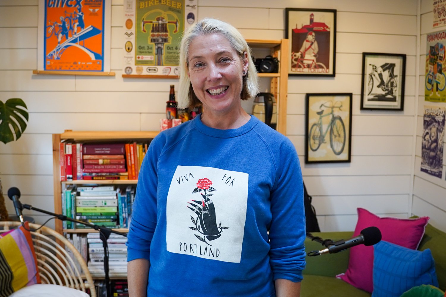
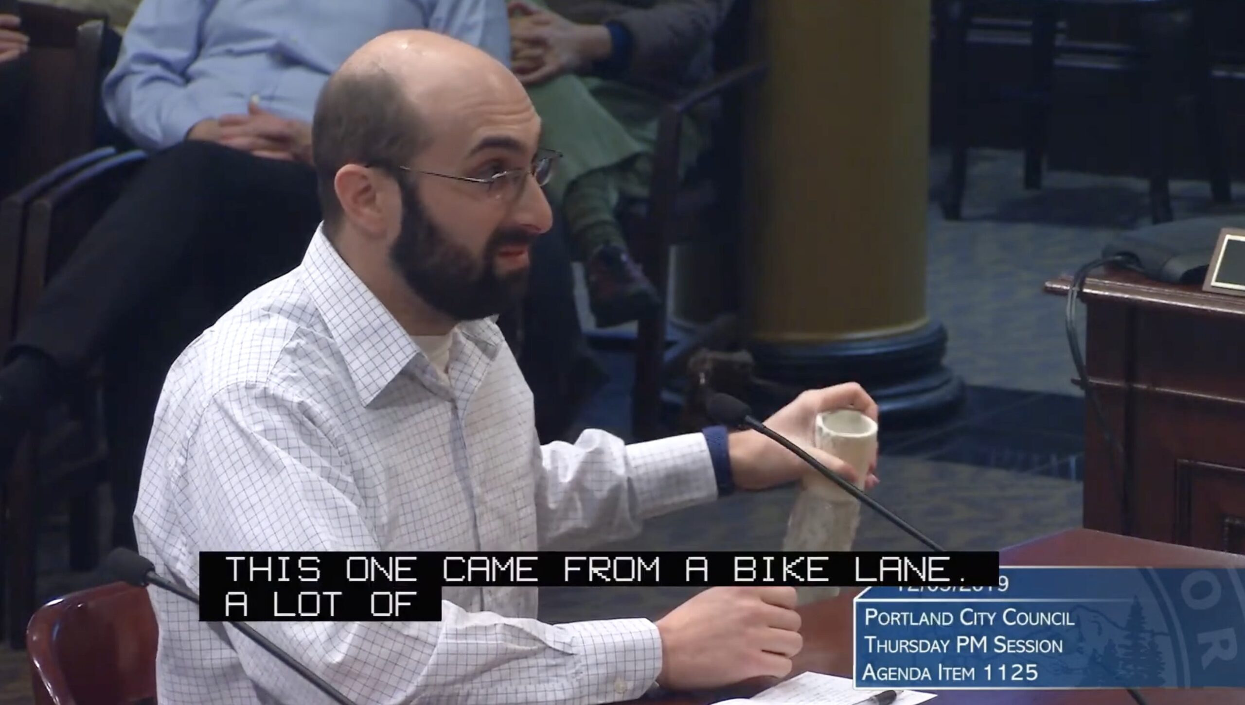
Portlander Sean Sweat has gamified our bewildering city council election. His new Rose City Hall card game lands just in time to help voters make sense out of dozens of viable candidates for local office. Sean is an MIT grad, supply chain expert at Intel, an urbanist, former vice chair of the Portland Bureau of Transportation Bureau Budget Advisory Committee, and an active member of the Pearl District Neighborhood Association.

I’ve bumped into Sean at several events in recent years (we first met at the first fundraising party for Just Crossing Alliance in 2022) as he’s settled into our community from his former hometown of Phoenix. When he said he created a card game based on the council election, I invited him over to the Shed for a closer look.

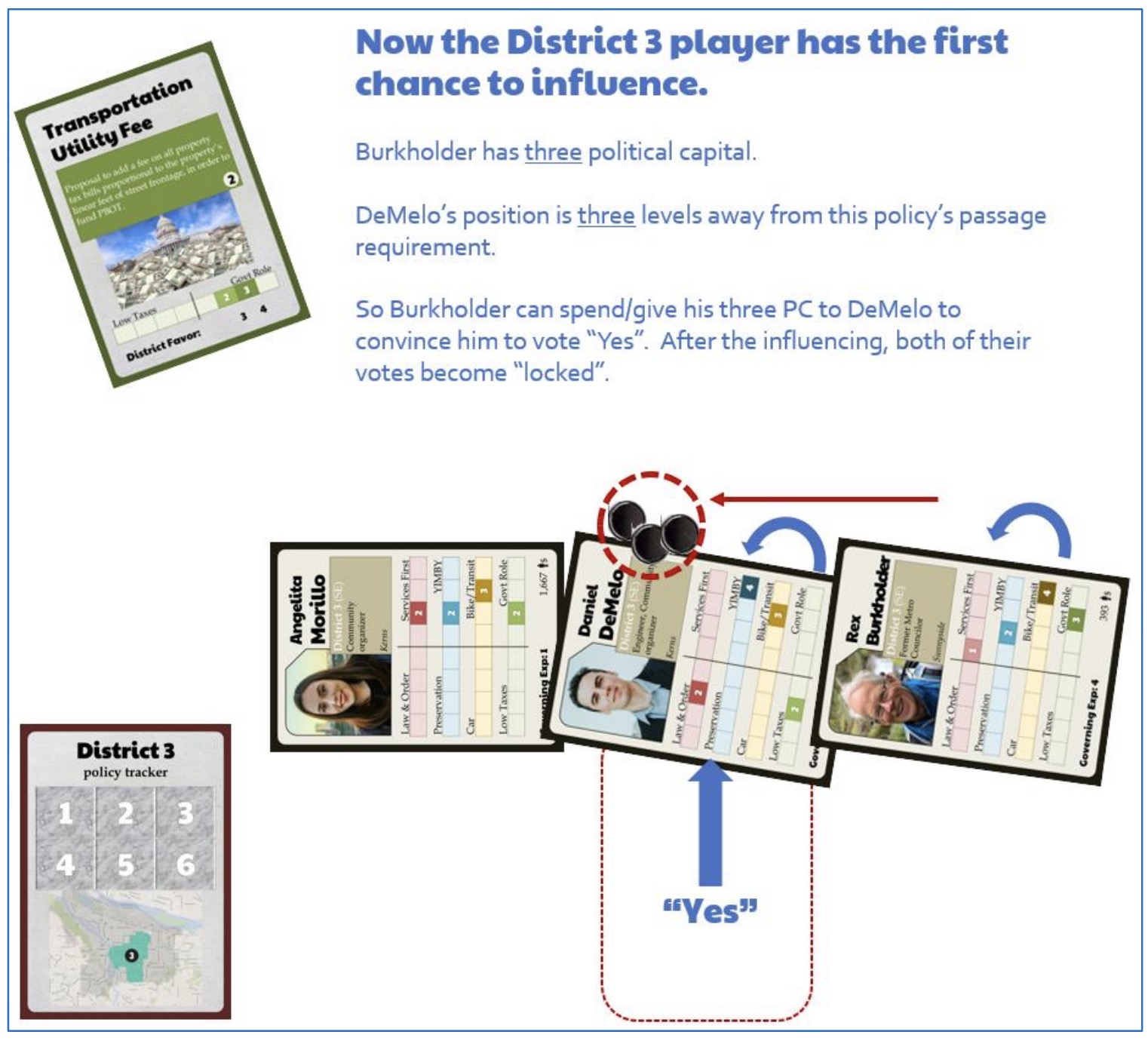
Here’s the short description of game play Sean posted on the Rose City Hall website:

Each player represents an influential figurehead in one of Portland’s four council districts. The districts will elect three councilors and the mayor, and then you will try to pass policies that your district’s voters favor. In the process, you can help your councilors gain and wield political capital to influence the outcome and shape the Portland you want to see!

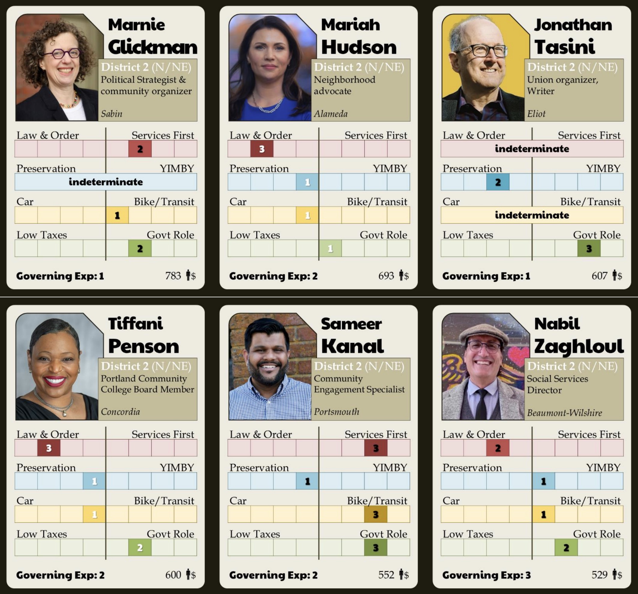
The feature of the game that excites me most are the candidate cards. There are 68 council and 7 mayoral candidate cards. Sean included cards of all candidates who have a campaign website, have earned at least 100 donations, and who answered and returned his questionnaire. He used the questionnaire and his own survey of available information to give every candidate a score between one and four on four key issues: enforcement of homeless camping, housing, transportation, and taxes. The score is presented on a spectrum between two poles of thought. For example, on the transportation line, “Car” is on the left of the spectrum and “Bike/Transit” is on the right (he flipped this purposely to move away from the traditional left/right political thinking). For housing, the left is “Preservation” and the right is “YIMBY” and so on. Candidate cards also include the district the person is running in, their job or background, and the neighborhood they live in.

The cards are really fun to flip through and make good conversation starters over coffee or tea with a friend.

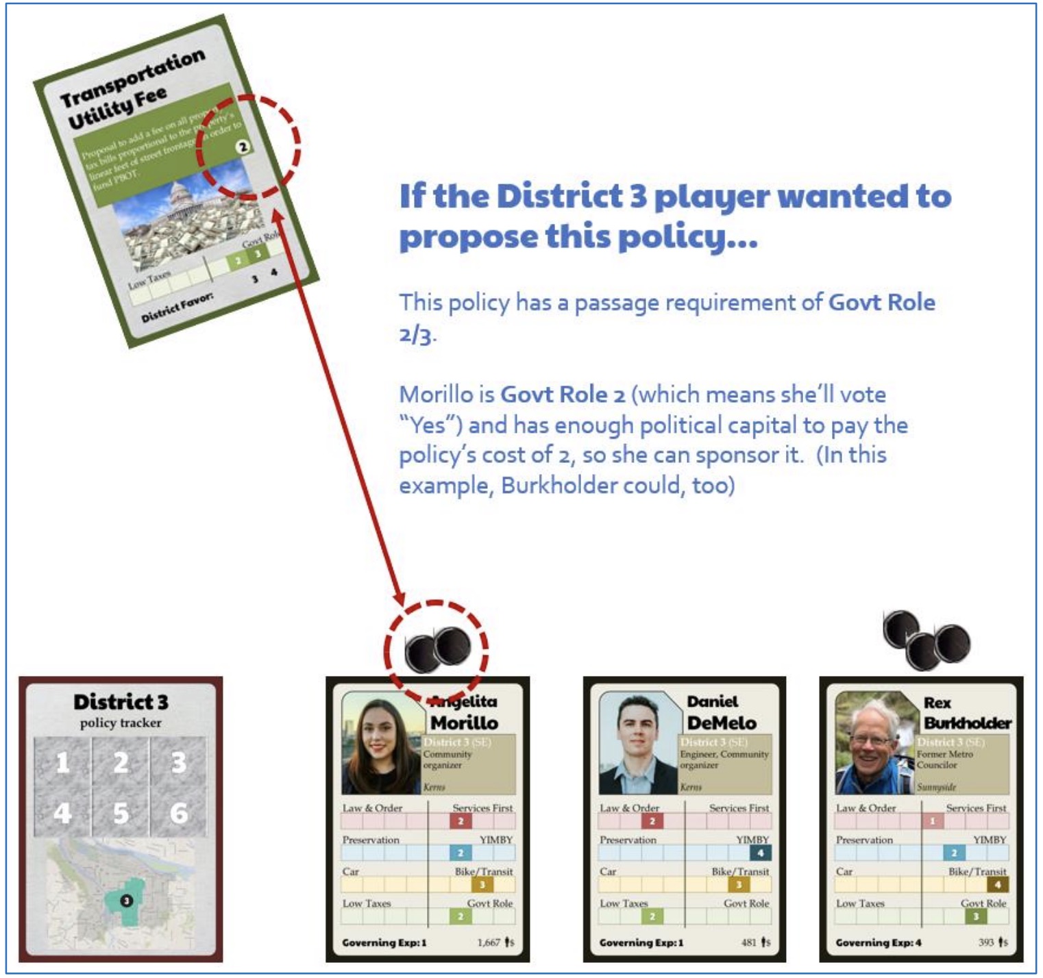
There are also 38 “Policy” cards that have values on them the correspond to how much political capital it takes to pass them, what minimum value on the issue spectrum a candidate needs to pass them, and which districts tend to favor the policy. Examples of these cards include “Expand Portland Street Response,” “Remove the Rose Lanes,” “Eliminate the Arts Tax,” etc…

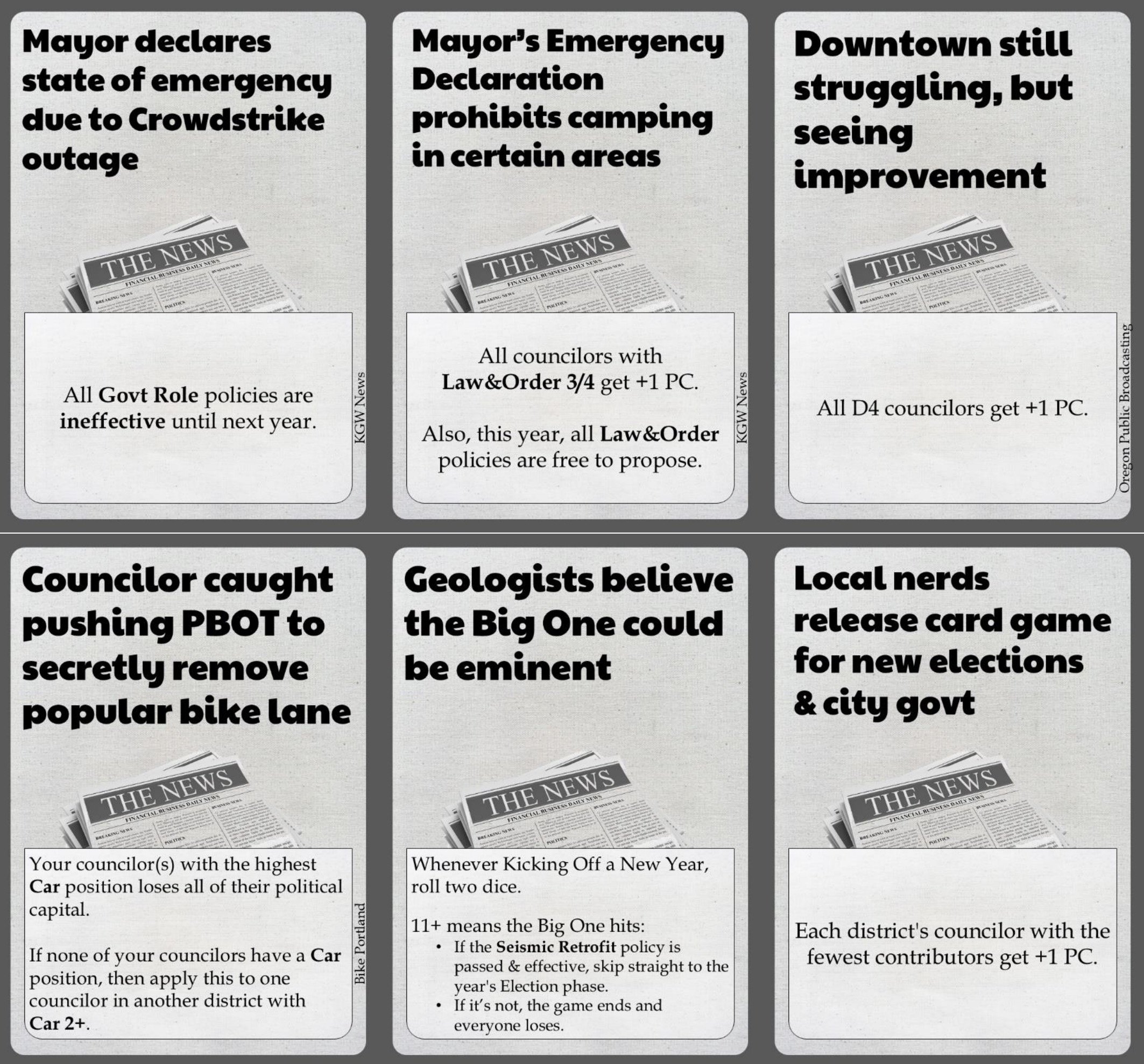
The stack of 19 “News” are another fun element that can shake up the game. They read like headlines and come with various consequences that impact the game. For example, the card titled, “Councilor caught pushing PBOT to secretly remove popular bike lane,” results in the candidate in your stable with the highest “Car” position losing all of their political capital points.

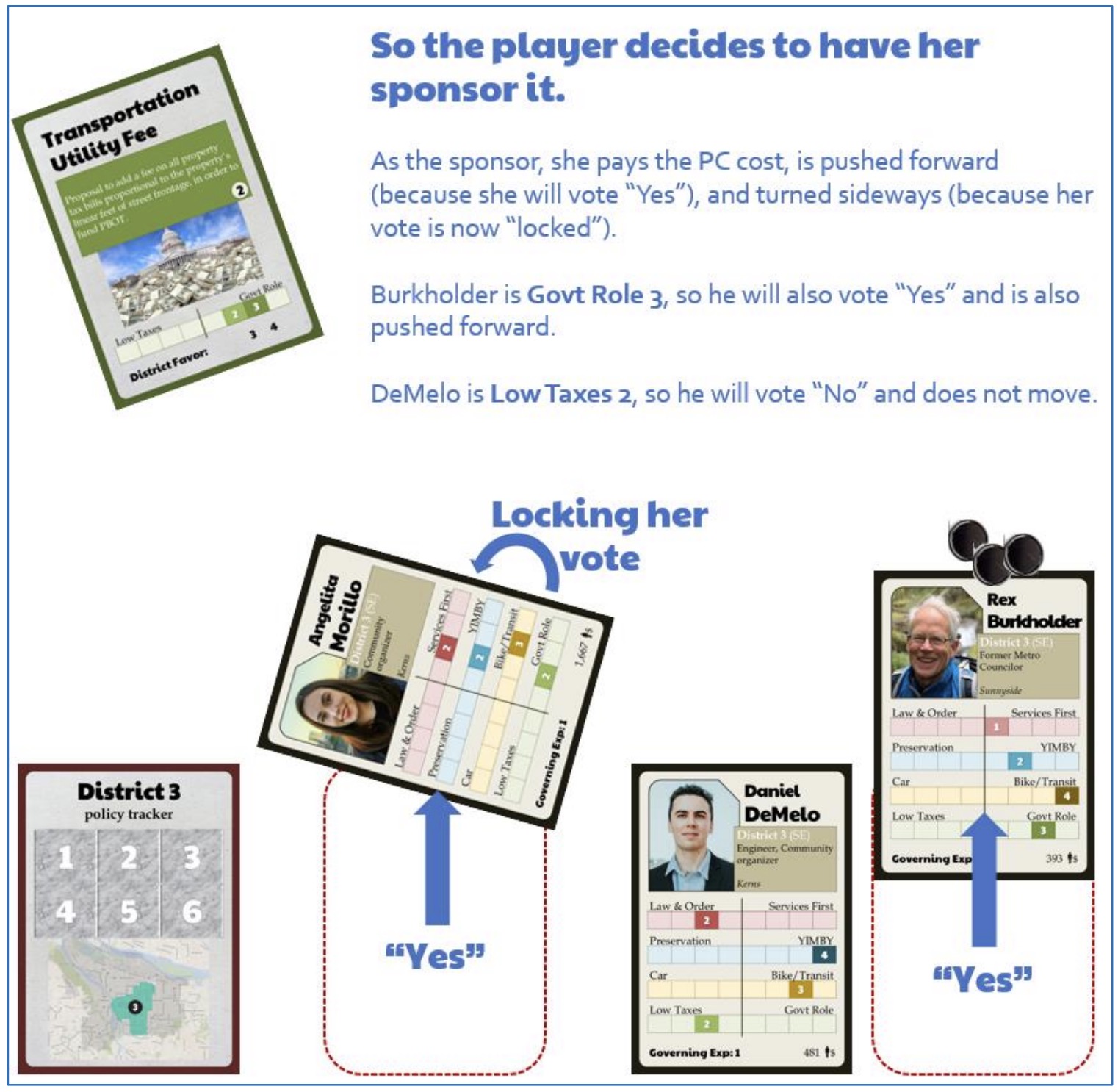
Each player represents a different council district whose three members are determined after a vote that combines “preference tokens” and a roll of the dice. The game play consists of reading News cards and trying to pass policy — which players can choose to support or influence. You can choose to play a competitive or collaborative game. In the competitive version, you win when three or more policies that favor your district have been passed and are effective. In the collaborative game, the council wins together once three effective policies are in place for each district.

This is peak Portland civic nerdery and I’m here for it! I’ll try to bring decks — or maybe Sean himself — to Bike Happy Hour soon. And if/when he or I make a video of the game play instructions, I’ll embed it here in this post and on our various platforms. I highly recommend taking time to get a set of these cards, and I hope Sean will offer booster packs for future elections.

The game is $35 for a high-quality, professionally printed version. You can also print the entire deck via a PDF on the game’s website for an estimated cost of $25 at a local print/copy shop. Read full instructions and find out more at RoseCityHall.com.

Podcast: Mayoral candidate Liv Osthus

Liv Osthus in the Shed earlier today. (Photo: Jonathan Maus/BikePortland)

Liv Osthus has taken a very unconventional path to being a viable candidate for Portland’s highest political office. The 50 year-old from Sioux Falls, South Dakota is the daughter of a Lutheran preacher who moved to Portland in 1996 and fell in love with our city’s infamously bohemian lifestyle. She’s been a professional stripper ever since and still works at Mary’s Club, where, with each dollar she takes from an adoring customer, she hones the catchphrase that has since become the title of a full-length documentary about her life, “Thank your for supporting the arts.”

Now this author, singer, speaker, single mom of a 9-year-old daughter and noted advocate for sex workers, is garnering attention on a different stage: politics. Osthus’ campaign for Portland mayor has caught fire in recent days and weeks as Portlanders seek an alternative to the status quo. She’s breaking through with memorable performances in debates and forums where she shares a vision of Portland that’s “full of hopefulness, not homelessness.”

Osthus jumped into the race relatively late with no money or volunteers, but has since garnered considerable amounts of both. What was once an innocent attempt to inject a new, optimistic and artistic spirit into the race, has become something more substantial. This week Osthus unveiled large campaign billboards (one of them is a spoof on the famous “Expose yourself to art” poster made famous by former Mayor Bud Clark that reads, “Expose yourself to politics”) and she’s a regular at high-profile events alongside the front-runners. With Portland about to rank votes for the first time ever, a sense of “What if?” still floats around her campaign.

In this interview Osthus ranks her choices for mayor with honest assessments of her competitors, explains why her top priorities differ from other candidates, shares her personal mobility story, tells me why the time is right for the Liv Osthus Era in Portland, and more.

Listen in the player above or wherever you get your podcasts.

— Learn more about Liv Osthus at her campaign website or her Rose City Reform Candidate page. You can also watch Osthus in the KGW/The Oregonian Mayoral Debate tonight (Tuesday, October 15) at 6:30 pm.

New signal at NE Going and MLK finally working, but most riders don’t use it

This rider rolled right past the push button on the right and crossed against the signal. (Photos: Jonathan Maus/BikePortland)

A new traffic signal on North Going Street at its crossing of Martin Luther Junior Boulevard finally went live last week. Portlanders first identified a need for the signal in 2017 as part of a batch of crossings to make getting to nearby schools safer and funding for it was adopted by Portland City Council in 2020.

NE Going is one of Portland’s most heavily used neighborhood greenways — which are streets that prioritize biking and aim to be low-stress and family friendly. This signal was highly anticipated because Going is such a key east-west bikeway and the state-owned MLK Jr. Blvd is four lanes of relatively high speed traffic. PBOT installed median islands in 2010 to make the crossing safer, but it remained stressful. In 2012 we shared an article by noted local lawyer Ray Thomas who called this crossing an excellent example of an “ambiguous intersection” where crossing behaviors can be unpredictable by both drivers and bikers.

Unfortunately, based on my observations yesterday, it doesn’t appear like the new signal will be as effective as many folks hoped. The problem is that the Portland Bureau of Transportation opted for a “beg button” instead of automatic sensor detection of bicycle riders. A person who wants to cross must push a button to make the signal function.

There are two buttons on each corner — one for people using the sidewalk, and the other for people biking in the street. The sidewalk button works well because it’s placed right where walkers typically wait to cross. But the bike button is placed about 10-15 feet behind where most bicycle riders wait at the intersection. This means the vast majority of them don’t see it and don’t use it. Once the button is pressed, it takes about 30 seconds for the light to turn green for NE Going traffic. So not only do you have to push it, the wait felt longer than other new bike signals in town (like the northern landing of the Blumenauer Bridge) that use automatic sensor detection.

The result? Most people biking across this intersection do so while drivers on MLK Jr. Blvd have a green light. I find that inherently problematic. This means So in some ways, the intersection is more dangerous because drivers now have the legal right-of-way when a bicycle rider is in front of them on a green signal, whereas before — when there was no signal — they were legally required to stop if a bicycle rider was already crossing. There are still too many unpredictable behaviors and close calls at this location. Keep in mind this is what PBOT calls a “half signal” where the major road (MLK) has a full red/yellow/green signal, but the minor road (Going) has no signal. That means bike riders don’t have to push the button and can legally cross after yielding when there’s a break in traffic. In a perfect world, this would all work out. But what we see in practice are some bike riders not making safe decisions and MLK users who see a green light and assume they have the right-of-way regardless of whether or not a bike rider has already established themselves in the intersection.

Note the people crossing against the signal in the four photos below. I’ve got more interactions recorded on video that I’ll share later today.

To see this after we waited four years for the signal was a bit disappointing.

PBOT Communications Director Hannah Schafer told BikePortland that the decision to use a beg button for this signal was a matter of dollars and cents. “The NE Going/MLK signal is part of a bundle of seven different signals that started off very low on funding and then was sent to bid twice before construction to meet our budget,” Schafer wrote in an email. “Unfortunately, this meant keeping the project as bare bones as possible, which meant not adding detection/bike signal heads into this design which would have added to the cost.”

That’s the bad news. But the good news, Schafer says, is that now that the signal is up and running and all the electrical bits are in place, it “would not be a major lift” to retrofit this intersection with detection down the road if/when funding is identified. Asked if the project is 100% complete and whether new pavement markings to encourage riders to push the button might still be coming, Schafer couldn’t say for sure at this time.

The full project (including six other signals) isn’t complete, so there might be room to add pavement markings in the future when the city goes through their final list of tasks. In the meantime, hopefully more folks push the button and no one gets hit.

Have you used this signal yet? What do you think about the change so far?


UPDATE, 10/16 at 10:02 am: I learned in a comment below from Ted Buehler (someone I know in real life and who’s knowledge I respect) that since this is a “half signal” — where only the traffic on MLK has a signal and Going just has the “Walk/Don’t Walk” sign — bike riders on Going can treat this like a de facto stop sign. That means if you don’t want to push the button and wait for MLK traffic to get a red signal, you can just roll up, yield, and then go if there’s a safe break in traffic. Learn more on why and where PBOT uses half signals here.

New videos show what I-5 freeway expansion over Columbia River would look like

View looking north from Marine Drive. Screenshot from IBR video flyover.

Flyover visualizations produced by the Interstate Bridge Replacement Program give us our best view yet on what the future of the I-5 freeway between Portland and Vancouver might look like after an estimated $7.5 billion investment. The project team has released these about half-way through a federally-mandated public comment period and only after they’ve raised over $4 billion and built considerable political inertia to begin the project.

The IBR team revealed a series of flyover videos at a Monday meeting of the Joint Interim Committee on the Interstate 5 Bridge, a group made up of legislators from Oregon and Washington. The “visual fly-throughs” were introduced at the meeting by Chris Regan, the IBR environmental manager.

Regan told lawmakers the videos were created to “help our community members better visualize and understand the potential investments that we’re studying.”

Scroll down for some before/after images of the interchanges and views of the future bikeway…

Marine Drive interchange looking north

Hayden Island/Jantzen Beach Interchange

Vancouver Riverfront

As you view these, keep in mind that the design is not yet final. The project has adopted a “locally preferred alternative” (LPA), in order to compare something to a “no-build” scenario, but within that LPA there are still several key design options under consideration.

The IBR is about half-way through a crucial public comment period on its Draft Supplemental Environmental Impact Statement (DSEIS). This week the project hosts its first two, in-person public hearings and these flyover videos will be shown at each of them.

The lack of high-quality visuals is something project-watchers have been clamoring for for a long time. How can the public and lawmakers weigh the need to invest billions in something that hasn’t even been revealed to them yet? Note that even without these visuals, the project has already secured over $1 billion from each state and $2.1 billion from the federal government for a total of $4.2 billion.

Bikeway integration (read captions for details)

As bicycle riders, the videos reveal the best look yet at how we’ll approach the river and cross onto the bridge structure, then return back to surface streets. Look through gallery of screenshots above for a closer look at how the bikeway interacts with the various designs.

Coming from the south, it appears like whether you come from east or west of I-5, the route onto the bridge will be much more intuitive and direct. West of I-5, the project will build a bikeway along N Expo Road that begins at Delta Park dog park. This bikeway will head north to Marine Drive and then go west under the new bridge structure, onto a ramp, and then up onto a new bridge that will connect to Hayden Island and/or continue northbound onto the main bridge structure before coming to a spiral ramp that leads from the bridge on the Washington side and connects to surface streets in Vancouver.

In the single-level design, the flyover shows tiny little specks that are bike riders and walkers, at the same grade as six other travel lanes. If the final design of the project calls for a double-deck bridge, the bikeway will go under the bridge deck. Unfortunately, none of these visuals show the view of the bikeway over the river in the double-deck bridge design. (For more on the bikeway elements, refer to this PDF map.)

These visuals mark an important milestone and should give more people the ability to form opinions and comments on the project. Watch them and consider attending an upcoming open house and don’t forget to share an official comment so your feedback is included in the official public record. The design can still be altered and refined if enough people share a similar concern about a particular element of the project.

To help inform your comment(s), imagine yourself living, walking, biking, or taking transit on and around these proposed facilities. How would you feel? What would make it easier and/or more attractive to you?

The Portland in-person public hearing and open house is this Thursday, October 17th from 5:30 to 8:30 pm at the Expo Center. Learn more about the event here.

Another north Portland bike shop is closing

Kenton Cycle Repair on N Kilpatrick in 2018. (Photo: Jonathan Maus/BikePortland)

When Kenton Cycle Repair closes its doors for good on October 26th there will be no bike shops in north Portland west of Interstate Avenue. The closure, announced by the shop’s owner Rich Walker in an email to customers on Saturday, leaves an 18 square mile swath of our city without a bike shop.

Kenton Cycle Repair opened on N McClellan Street right off the Kenton neighborhood’s main drag, Denver Avenue, in 2012. It was started by Walker and a co-owner Starmichael Bowman, two friends who shared experience working at local nonprofit bike organizations (Community Cycling Center and Bike Farm, respectively). The shop outgrew that space and moved into a much larger one on N Kilpatrick in 2017.

The shop’s official email didn’t share any reason for the closure. There was no farewell message, just the words “We are closing forever” in large red font. I emailed Walker to confirm rumors I started hearing last week and he confirmed the news. “I still love working on bikes but the business has become personally and financially unsustainable in the last few years,” he shared.

For folks who live, work and play on the north Portland peninsula, it’s just the latest in a string of bad bike shop news. Five bike shops along the Interstate corridor and west to St. Johns, have closed since 2020.

Walker’s former co-owner Starmichael Bowman left Kenton Cycle Repair to open Norther Cycles in 2015, only to throw in the towel in 2020. Revolver Bikes on N Rosa Parks Way and Interstate closed just one month later. Block Bikes, the only bike shop in St. Johns for a few years, closed in 2022. And back in February of this year, Golden Pliers bike shop on N Interstate and Skidmore moved to NE Alberta Street into the space formerly occupied by Gladys Bikes — a shop that closed in 2024 after 10 years in business.

Besides the big box retail offerings of Fred Meyer or Dick’s Sporting Goods in Janzten Beach, the closure of Kenton Cycle Repair leads to a vast bike shop desert. Of the three bike shops that remain in the area, only one of them services and sells a wide range of bikes. PxCycle on N Interstate in Kenton is a single brand, e-bike-only store and The E-Bike Store also only sells electric bikes. That leaves North Portland Bike Works on N Killingsworth and Albina as the only traditional neighborhood bike shop in the area.

The bike business has always been a tough one, but these past few years have been absolutely brutal. After riding a wave of cycling interest during the pandemic, shops bet big on inventory to meet demand. If they could even get the products they wanted due to supply chain issues, some shops soon felt softening enthusiasm once things opened back up. Add to that a loss of business from people who opt for “direct-to-consumer” purchases where brands cut shops out of the equation and ship directly to customers. Another factor is the reduction in cycling overall thanks to a number of factors including the shift toward working from home. Daily commuters were in constant need of gear and service when they biked into the office, but that chunk of sales has dropped precipitously in recent years.

At our peak in 2014 or so, Portland had well over 70 bike shops. A list maintained by the City of Portland shows just 49 currently open bike shops citywide.

Kenton Cycle Repair’s last day is October 26th. Roll over to 1926 N Kilpatrick to thank Rich for his years of solid service and to help him liquidate remaining inventory.

KentonCyclePDX.com

Comment of the Week: The freeway expansion fight is Metro’s fault

Tell me about the forest, not the individual trees. Which is to say that I am always drawn to comments which give me a big picture understanding of why things are the way they are. Take the Interstate Bridge replacement and freeway widening projects. My eyes go over all the text BikePortland has published. I look at the diagrams. But, frustratingly, I don’t retain the information. I’m not proud of that.

But what helps me are comments like what ITOTS wrote this week, into Jonathan’s interview with Je Amaichi on the Interstate Bridge freeway project. ITOTS brings up Metro, and its Regional Travel Demand Model, and goes on to say that it is this model which says we need a $10B freeway expansion, and which gives “cover” to the DOTs. S/he ends with a link to a Jarret Walker blog post.

Metro’s Regional Travel Demand model wasn’t on my radar, but it sure gives me an understanding of the larger problem. And it’s those nuggets of insight which keep folks reading the BP comments sections.

Here’s what ITOTS had to say:

When it comes to the DEIS, Amaechi said the over-arching concern is its “defeatist way of thinking.” In other words, she thinks it assumes the status quo of car and truck-centric transportation will exist well into the future (projects and models in the DEIS are based on 2045)…“This idea that we’re alleviating congestion by adding lanes is something that has been disproven many, many times,” she added. “And in fact, the opposite has been proven to be true. Induced demand is slightly mentioned [in the DEIS], but it’s not addressed in a realistic way.”

Two things:
First, even without any projected growth in traffic, the DOTs/IBR can and would determine that for safety and operational reasons they require the new auxiliary lanes. They can make a case for auxiliary/merge lanes based on close spacing of interchanges, short merge distances, and grades alone. Given the ultimate judge is Federal Highways they would easily win any dispute there. The DOTs don’t even need to have a fight about whether or not induced demand exists or is accounted for because they don’t have to rely on increased traffic volumes to justify their wider design.

Second, it’s actually Metro that allows/requires them to build a wider highway. Metro maintains the regional travel demand model and the list of projects and programs that go into it. When the impact of all of the region’s planned projects and programs are tallied up, Metro’s travel demand model is still saying that auto traffic is going to increase across the Columbia river by year 2045 (or pretty much any other year in the future) such that doing nothing leads to carmaggedon. IBR is required to plan to accommodate that predicted future, to study the impacts of not doing so (which is part of what is in the SDEIS), and to design a facility that meets DOT mobility standards—hours of congestion on the main line, level of service at intersections.

So go tell Metro to fix its modeling, principally by adding projects and programs that get the region to the mobility, safety, and sustainability outcomes we want without these kinds of mega projects—at least inside the reductive reality of the model. And then fund the projects that are going to get people to move around the region differently. It’s Metro’s model that tells us we need this $10B project. That’s all the cover the DOTs need.  Making plans to bring about a future that you say you don’t actually want to come to pass is absurd. But thems the rules (currently).

There are other (saner and still rigorous) ways.

Thank you ITOTS. It’s hard to stay abreast of those projects, so your bigger picture helps. You can read ITOTS comment under the original post.

Monday Roundup: Highway robbery, carfree in America, and more

It’s Monday! Time to round up the best news and stories from the past week…

Mad about models: This week’s must-read is a breakdown of very troubling traffic modeling used by DOTs and highway builders to justify spending billions on megaprojects just like our very own freeway expansion between Portland and Vancouver. This article dovetails perfectly with part of the conversation between Je Amaechi and I last week. (Dissent Magazine)

**Sponsored by The EBike Store**

Sidewalks matter: A haunting story about a six-year-old boy who was killed by a driver on a road in a Black neighborhood without sidewalks 35 years ago. (KFF Health News)

A carfree status report: Always interesting when a mainstream media outlet parachutes into our world. In this case, a reporter talked to Americans who’ve — shock! — managed to give up a car and not regret it. I like how the takeaway is that, given the choice, most people would be happy to live low-car or carfree lives. (The Washington Post)

College paper chimes in on Willamette bike lanes: PBOT’s big project to change the design of N Willamette Blvd is directly adjacent to University of Portland and the college’s newspaper reports why students are watching its progress closely. (The Beacon)

Speed limits during races: Interesting situation has bubbled up in the UK after authorities establish 20 mph zones and organizers of cycling races must detour around the zones in order to keep their caravans in compliance. (Cycling Weekly)

Lessons learned: I’ve been a fan of Russ Roca since the early days of BikePortland and it’s been amazing to watch him grow into such a respected YouTuber while not compromising his vision or independence. His recent post on things in his life and the bike industry he wished he’d known sooner is well worth watching. (Path Less Pedaled on YouTube)

War for a carfree road: The battle playing out in San Francisco over a measure that would permanently prohibit drivers from using a portion of a coastal road is just the latest example of how deeply some people resist change — especially when it involves cars. (The San Francisco Standard)

For the record: I was happy to at see our state’s main news outlet attempt to correct the record about the type of vehicle a Tigard teen was riding when he was killed on a road in Tualatin last week, but then the article still mentions “e-bike” so many times I’m not sure it really helps much. (The Oregonian)


Thanks to everyone who sent in links this week. The Monday Roundup is a community effort, so please feel free to send us any great stories you come across.

What happened on Hawthorne, and what’s next?

Conditions as of Wednesday (10/9). Red line shows striping location County initially installed but then rolled back.

The community is still processing how Multnomah County engineers and planners could have ever approved a design for the Hawthorne Bridge viaduct that put bike riders in even more risk than usual.

Over the course of a week or so, we learned that the County changed the existing bike lane design at the SE Clay/Martin Luther King Jr Blvd off-ramp, then changed it again after hearing such a loud backlash. Now many folks are wondering how this opportunity to fix a clearly dangerous intersection was missed and what can be done going forward.

To back up a bit, this work from the County was done as part of a $9.5 million paving and maintenance project. Like we’ve seen from Portland Bureau of Transportation, the County took advantage of a clean slate to make adjustments to the bike lanes on the viaduct, including a tweak to the SE Clay offramp. Why? Because it’s common knowledge that this through bike lane and right-turning general vehicle lane is a conflict point.

Given the critical tone of my story about the change Wednesday, and the fact that at least one person was actually hit at this location after the change was made, I was eager to hear more about the thinking behind the design change from the County. Surely they could supply some sort of rationale for the striping shift that created a very awkward angle for bike riders while doing nothing to deflect or deter driving movements.

I didn’t end up learning anything new from the County. In a statement emailed to BikePortland Thursday afternoon, they acknowledged receiving “a lot” of feedback about the initial change and said they made, “immediate changes to that bike crossing to reconfigure it to better align with what was previously in place.” A few hours after my story posted, I rode by the intersection and uploaded a video (above) of the reconfiguration to verify that it had, indeed, been returned to its previous design.

Wednesday night also happened to be the monthly meeting of the Multnomah County Bicycle and Pedestrian Community Advisory Committee. I know a few members and they assured me this topic would be discussed. They also shared the BikePortland story and video with committee members and County staff at the meeting.

One of the committee members, Andrew Holtz, was willing to share his personal reflections about the situation (note Holtz is speaking only for himself in these comments and is not authorized to speak on behalf of the committee). What does Holtz think happened?

“Rather than an ‘oversight’, my sense is that the real world outcome was unanticipated and that the effect of the angle change was thought to make it easier for people on bikes to see cars coming without having to turn their heads as sharply,” Holtz shared in an email to BikePortland. He based that feeling on recollections of a discussion at the committee one year ago when County staff presented on the project.

“It seems there wasn’t much discussion of the angle change because it didn’t seem like it would make much difference. And there was some thought from committee members that a sharper angle would make it easier to turn and see drivers coming,” Holtz added. He also shared that County staff plan more discussions about how the change was developed and what lessons can be taken from this experience. Staff will likely address the committee about this future at a future meeting. “It’s fair to say everyone, committee members and staff, are looking for lessons for the future.”

Design concept of Hawthorne Bridge viaduct at SE Clay St offramp by Nick Falbo (as a private citizen, not attached to any government agency).

To the County’s credit, they changed course quickly and altered the design. But this back-and-forth has triggered interest from several people to actually make the design safer.

Nick Falbo, an urban planner and infrastructure designer who earned acclaim in his field for pioneering work on protected intersections and worked at PBOT for six years, shared a drawing on Bluesky this morning for the design he’d recommend. Falbo’s drawing shows a raised crossing and concrete islands to create a more predictable path for bike riders and slow drivers in the turn. “Drivers should yield to people walking and biking, and we should design the crossing so that behavior is intuitive,” Falbo wrote of his “Dutch-inspired” design.

And a local bike advocate who I’ll keep anonymous for now, copied BikePortland on an email to a member of the County advisory committee that shared a PBOT plan drawing of this intersection. The drawing was created for PBOT’s Central City in Motion plan, a list of 18 recommended projects that includes revamps to improve biking and transit service on SE Hawthorne and Madison.

The CCIM conceptual design (above left) for this intersection shows a bike signal at the off-ramp. The bike signal would be triggered by approaching riders and an existing signal head that blinks yellow would be upgraded to a full signal for right-turning drivers. PBOT’s website says designs for the project have been finalized, “and will be delivered by Multnomah County.” But somewhere along the way, the signal element of the project has not been delivered. I’ve asked PBOT for an explanation and will share more when I hear back.

We clearly have solid options to improve this intersection and now there’s considerable public urgency to do something. It’s unfortunate this opportunity was missed, but I feel confident in saying a longer-term, higher-quality fix is now squarely on the radar. Stay tuned.

Southwest uber-advocate pushes new approach in city’s ‘hardening’ strategy

Section of Beaverton-Hillsdale Hwy PBOT plans to harden with concrete curbs and fewer plastic posts. (Photo: Jonathan Maus/BikePortland)

When longtime southwest Portland cycling advocate Keith Liden told me he was going to present his reasons for not wanting the plastic delineator posts on Beaverton-Hillsdale Highway “hardened”, the first thing that came to my mind was David Stein. The former chair of the Bicycle Advisory Committee (BAC), where Liden presented Tuesday evening, is a bouncing figure at the BAC Zoom meetings (he attends them on a treadmill), and he has been vocal for years about not liking the plastic posts.

As BikePortland reported last month, the Portland Bureau of Transportation (PBOT) is planning to replace some of its plastic delineator posts along bike lanes with more concrete curbs — it is going to “harden” them. And isn’t that what cyclists, including Stein, have been clamoring for?

The reason I thought of Stein was because I remember vividly the 2019 City Council session in which the Southwest in Motion (SWIM) plan was presented. Stein was one of the first persons to testify, and he brought a prop with him to the hot seat in front of the council dais — a broken plastic post he had retrieved from Beaverton-Hillsdale Hwy. Waving it before the Commissioners, he testified, “We need to do better than this!”

Five years later, enter Liden, with his usual thoughtful, well-researched and persuasive arguments. Here’s what he told the BAC on Tuesday night.

Liden’s case against Beaverton-Hillsdale Hwy hardening

(Source: Keith Liden)

The main thrust of Liden’s criticism is that the hardening project is premature. Calling B-H Hwy “the strongest link in the chain” of a poor network, Liden told the BAC Tuesday night, “most of the streets that you connect to are hostile bike environments.” “It’s not even that they don’t have facilities, it’s that they are actually hostile.”

The problem is that connectivity is so poor in southwest Portland that a cyclist doesn’t have a safe route to reach B-H Hwy. I think it helps to think of B-H Hwy as a river, and to view the few streets which cross it as very infrequent bridges. Those crossings are used by all modes—cars, pedestrians, cyclists—and except for Terwilliger Blvd, they don’t have sidewalks or bike lanes.

The blue bars show the streets which fully cross Beaverton-Hillsday Hwy. Yellow arc is area of proposed hardening of plastic delineator posts.

Shattuck Rd, where the proposed development of the Alpenrose Dairy is located, is a good example of this. Shattuck Rd lies at the center of PBOT’s proposed B-H Hwy post hardening project (between 39th and 65th Avenuess). Shattuck doesn’t have sidewalks or bike lanes either to the south of B-H Hwy, or to the north. Yet adding walking and biking facilities to Shattuck has been part of the Transportation System (TSP) and Southwest in Motion (SWIM) plans for years. The most recent controversy involves the Alpenrose neighbors who, to no avail, have been asking the city to extend the multi-use path on the proposed Alpenrose development’s frontage all the way to B-H Hwy.

This lack of coordination between the Alpenrose development and the B-H Hwy hardening project is another example of the city’s bureaus not rowing together. And these close-but-no-cigar gaps that arise from repeated missed opportunities are frustrating for residents to watch.

Liden went on to make the case that any money the city had for improving bike facilities would be better spent on Terwilliger Blvd, mainly because the ridership is so much higher—between 360 and 515 trips at various locations on Terwilliger, versus 70 trips per day at B-H Hwy/Shattuck. Or, as Liden summed up, “PBOT needs to think beyond making a bike facility segment really good and ask, ‘Will it do any good?'”

The project selection gripe

The notorious bike lane gap on SW Terwilliger near SW 6th. (Photo: Jonathan Maus/BikePortland)

In addition to the Terwilliger having the greatest southwest ridership numbers outside of downtown, projects for filling the gaps in the Terwilliger route have been on the books since the 1990s. And that gets to the heart of Liden’s frustration, one shared by many southwest transportation advocates.

Advocates have spent hours and years working on project prioritization lists with the city. The SWIM project has spreadsheets of prioritized project lists, put together by an advisory committee. Hardening the posts on B-H Hwy is not on any of those lists, nor is it on the TSP. But Terwilliger is. This top-down project selection, outside of existing project lists and without community input, is an ongoing issue.

The colors of money

In response, City Bicycle Coordinator Roger Geller pointed out that PBOT has heard, “including from this committee, in written communications” that the plastic wands “don’t provide the level of comfort that we desire.” “And we are hearing very clearly messages about ‘make something permanent, use concrete rather than plastic.’ ”

Here’s more from Geller at the BAC meeting in response to Liden’s presentation:

This was also driven by the maintenance burden the posts were putting on our crews. Especially B-H Hwy, that’s probably one of our highest offenders. Those posts disappear with great rapidity, David Stein brings it up in almost every meeting…

We have a limited amount of money available to us, about half a million a year, which we are putting toward delineated bike lanes. Focusing on those that are putting the highest maintenance burden on us, or that are causing perception issues, I guess because of their aesthetics, particularly in commercial areas. Broadway and downtown is an example of that… Keith is saying , ‘Shift that money to Terwilliger,’… there are many colors of money. The work on Terwilliger, on Duniway Park is being funded as a risk-mitigation associated with a large BES sewer project… We’ve tried to get federal money for southwest Portland, and that’s money that is administered through the regional government, Metro. The southwest projects typically have not scored well with the criteria that Metro set for using those funds. Other than Capitol Hwy.

And then David Stein jumped in with some questions:

David Stein and his plastic post at Council in December 2019.

Stein: About projects in SW not scoring well with some of the regional and federal money, that’s because of equity scoring, correct? Or is that something else?

Geller: Equity is becoming more of a consideration in recent years, but, in the past a lot of the scoring was based on how well the facilities we would build would connect to regional and town centers. And so some of the southwest facilities didn’t score well relative to facilities elsewhere in the region.

Stein: Because there’s no stormwater management, so there’s no existing facilities, so if you want to build any facility and it doesn’t connect…

Geller: Well it was just the expense of building facilities in southwest relative to how well they connected into dense, commercial areas, which is how the criteria has often been set.

Then Liden interjected…

Liden: So it’s a little of a cost/benefit. How many people are you benefitting with the amount of money? And I guess that’s partly what I’m arguing with these two projects.

My takeaway

It was a revealing conversation, I left the meeting thinking that, in the southwest at least, projects are built, not according to a list of priorities, but rather in the order that funding sources are identified. That, or when a project can piggy-back on work happening with another bureau.

So implementation of southwest projects ends up being an excruciatingly slow bingo game, where the rows never seem to quite get filled. Keith Liden has been playing funding bingo for three decades, and his Terwilliger row still has a lot of empty spots.

Weekend Event Guide: Close-in ‘cross, Crown Z, fall colors, and more

All the feels at the PIR Heron Lakes finish line. (Photo: Jonathan Maus/BikePortland)

There’s a wide range of things to to by bike this weekend. Don’t miss these dry and delightful fall days!

This week’s guide is made possible by The E-Bike Store, Portland’s original all-electric bike shop that offers top brands and top service.

Saturday, October 12th

Banks-Vernonia Fall Colors Ride – 8:30 am in Downtown Hillsboro (West Side)
Ride Westside invites you on an excursion into the countryside where you’ll experience eye-popping fall vistas along one of the best carfree paths in Oregon (once you get onto it from Hillsboro). More info here.

Deaf Look Club Ride – 10:00 am at Woodstock ASL Cafe (SE)
Trouble hearing? Join other riders with communication barriers and folks who are into sign language on this bi-monthly group ride. More info here.

Measure 117 Bike Ride – 12:30 pm at Rosewood Initiative (SE)
Curious about the effort to expand ranked choice voting statewide? Come join folks who support the measure for a presentation and ride. Check out the Bike Works by P:ear shop right next door while you’re there. More info here.

Explore the IBR Project – 1:00 pm on Hayden Island/Jantzen Beach Center (N)
Join The Street Trust, Oregon Walks and 40-Mile Loop to get a first-hand look at the changes being proposed for bicycling by the Interstate Bridge Replacement Program (IBR). This is a great opportunity to learn about this project and inform your comments that you can submit until November 18th. More info here.

Sunday, October 13th

Cyclocross Crusade – All day at Portland International Raceway (N)
It’s race two of the Crusade series and it’s right in our backyard! The Heron Lakes course is a classic featuring a very spectator-friendly course that includes fast flats, a challenging run-up and more. More info here.

Explore Overlook Neighborhood – 9:30 am at Stacks Coffeehouse (N)
The transportation chair of the Overlook Neighborhood Association has extended you a personal invite to roll around this beautiful neighborhood, learning its strengths and weaknesses from a cycling perspective. More info here.

Crown Z Backroads – 10:00 am at Ruley Trailhead in Scappoose (Columbia County)
If unpaved adventure is your thing, this is your ride. Seltzer Cycling Club will lead you on the Crown Z to Vernonia, then onto logging roads along the Nehalem River and then back toward Highway 30 via the historic Pittsburgh logging town. I can vouch that this is an extremely fun and gorgeous route! More info here.

Ride to Tweed Party – 2:00 pm at Cartopia Food Carts (SE)
Don your finest tweed outfits for a civilized cycle to the 10th anniversary party at local Wildwood & Company clothing store. Consider this a tune-up for the official Tweed Ride coming this spring! More info here.


— Did I miss your event? Please let me know by filling out our contact form, or just email me at maus.jonathan@gmail.com.

Catching up on the Interstate Bridge freeway project with Je Amaechi (Video)

The project to expand five miles of Interstate 5 between Portland and Vancouver and replace the Interstate Bridge reached a big milestone last month with the release of the federally-mandated Draft Environmental Impact Statement (DEIS).

The Interstate Bridge Replacement Program DEIS (actually the SDEIS in this case because it’s a “supplemental” EIS that builds on the old EIS from the Columbia River Crossing project which was the precursor to the IBR) reveals key details about what we’ll get for the estimated $7.5 billion price tag and it opens a public comment period that runs through November 18th.

I plan to dive into the weeds of the active transportation infrastructure and other salient elements of the DEIS in future days and weeks, but to re-ignite our coverage of this megaproject, I interviewed someone who’s deep in the activism trenches. Je Amaechi (“Jay A-may-chee”) is a community organizer with Just Crossing Alliance, a coalition of dozens of environmental, transportation, and social justice nonprofits working to influence the project. Among the partner organizations is BikeLoud PDX, The Street Trust, No More Freeways, Oregon Trails Coalition, Oregon Walks, and others.

“One thing all the members have in common is this urgent need to mitigate and adapt to climate change and the need to balance all the fiscal needs with all the other infrastructure priorities,” Amaechi said during our video interview on Wednesday.

Amaechi and her crew are working hard to educate our community about the project. Given the dizzying amount of information to get a handle on, Just Crossing Alliance has put together a helpful list of links to official public hearings and other events. Amaechi also wants to help log as many official comments as possible. Why? “These public comments are important is because it’s building a record for potential future actions,” she shared. “Public comments become part of the official record… so they can’t say, ‘Well, we didn’t know this,’ or, ‘We weren’t aware.'”

“The assumption that we have to build it in a Robert Moses-style freeway expansion way and the prioritization of car infrastructure: That’s the thing that fundamentally we don’t agree with and we say that there are better ways that we can design this bridge for a future that like more Portlanders want to see.”

– Je Amaechi, Just Crossing Alliance

The way I see it, comments like, “Don’t build this bridge!” probably won’t be very influential because at this point it doesn’t look like anything can stop the project’s inertia. So far Oregon and Washington departments of transportation have raised over $4 billion (split between federal grants and state allocations). Barring some unforeseen opposition or glitch, it will likely move forward eventually.

Even Just Crossing Alliance isn’t trying to stop the project. Their goal is to right-size it and bend project leaders — and the elected officials who hold the pursestrings — toward new perspectives and possibilities.

When it comes to the DEIS, Amaechi said the over-arching concern is its “defeatist way of thinking.” In other words, she thinks it assumes the status quo of car and truck-centric transportation will exist well into the future (projects and models in the DEIS are based on 2045). “This way of thinking limits the possibilities for this bridge and how it could serve a lot of different populations,” she said.

Amaechi says many folks are worried about the financial commitment this bridge demands — both from our state coffers and from the pockets of everyday folks. Tolls will be a big part of the revenue picture, and those tolls are likely to hit some groups much harder than others if carveouts and subsidies aren’t well-crafted.

Then there’s the simple fact that this is a massive expansion of freeway lanes and driving capacity.

“The assumption that we have to build it in a Robert Moses-style freeway expansion way and the prioritization of car infrastructure: That’s the thing that fundamentally we don’t agree with and we say that there are better ways that we can design this bridge for a future that like more Portlanders want to see,” Amaechi said.

“This idea that we’re alleviating congestion by adding lanes is something that has been disproven many, many times,” she added. “And in fact, the opposite has been proven to be true. Induced demand is slightly mentioned [in the DEIS], but it’s not addressed in a realistic way.”

Amaechi believes the modeling and design options laid out in the DEIS make it clear that DOTs on both sides of the river are planning for a future many Just Crossing Alliance partners and their supporters simply don’t want. She acknowledges that people will continue to drive and need goods delivered by trucks in the future, but if our projects tilt too much toward serving those needs, we’ll be locked into the same earth and community-destroying ways of life that have hastened climate catastrophe across the globe.

With an investment of this size, we should build infrastructure that truly moves the needle for biking, walking and transit. Current plans for the bikeways begin on N Expo Road by Delta Park dog park, where the IBR will create a bike lane toward Expo Center to connect to new paths and bridges over the Columbia River. While the DEIS talks about shared-use paths and protected bikeways, Amaechi says it will take work to make sure the project builds excellent and safe bike infrastructure that is welcoming too all riders and skill levels.

The new bridge is likely to be much higher than the existing one, requiring bike riders to scale some sort of long spiral ramp to reach the top. “For people who are new to biking, just looking at one of those spirals is very scary — especially if they’re talking about these things being 100 feet in the air.”

If you’re curious how changes proposed in this project will connect (or not) to the existing bike network, sign up for “Riding Toward the Future: Exploring IBR’s Impact on Active Transportation in Oregon.” The ride is Saturday (10/12) at 3:00 pm and will be co-hosted by Oregon Walks, 40-Mile Loop, and The Street Trust.

And stay tuned to BikePortland, the JCA’s work and the official IBR website to stay engaged on this important project.

Oregon State Parks e-bike rule change takes key step forward

(Photo: Oregon Department of Transportation)

The State of Oregon has taken an important step toward what could be a big change to where electric bikes can ridden. On Wednesday, the Oregon Parks and Recreation Department (OPRD) announced that the official rulemaking process has begun for where e-bikes can be used in state park properties and the Oregon Coast.

It’s the latest move as the State grapples with a boom in popularity of bicycles with motors. As we reported in 2017, e-bikes were technically illegal on any paved path within the state parks system until the rule was clarified in 2018. Currently, products that fit the legal definition of electric-assisted bicycle (ORS 801.258) are allowed on state park trails that are over eight feed wide (unless otherwise posted) and anywhere cars and trucks are allowed on the ocean shore.

According to OPRD’s statement this week, “The proposed changes would update definitions for electric-assisted bicycles and determine new locations where they are allowed and restricted.”

The OPRD Rules Advisory Committee will meet to discuss the changes at a meeting October 17th. The meeting agenda will include, “discussions on the impacts the proposed rules would have on visitor safety, recreational uses and conflicts, operational best practices and accessibility,” OPRD says. “The committee will also discuss the potential economic and fiscal impact of proposed changes.”

This move comes in response to a bill passed in the 2023 legislative session (HB 42013) that becomes law on January 1, 2025. That law will add more detailed e-bike definitions into the Oregon Revised Statutes: Class 1 (20 mph max speed with no throttle), Class 2 (20 mph max speed with throttle) and Class 3 (28 mph max with no throttle).

OPRD sought public comment on this issue last summer, so the rules committee will already have something to work with. After their initial meeting next week, three more meetings to discuss the rule will be announced. A public comment period will open in early 2025 once the newly proposed rule has been crafted and polished by the rules committee and OPRD staff.

Cycling advocates and e-bike users should watch this process very closely. Given that riding e-bikes is a relatively new and very widespread activity in state parks — and the fact that what many people consider “e-bikes” are often not — this new rule must strike a balance between access for and encouragement of e-bicycling, and keeping parks safe.

Learn more about the rule change and how the process will go from here on OPRD’s website.