(UPDATE, 3:30 pm: County has completed changes and it works much better now. Watch video below for current conditions.)
A Multnomah County redesign of the eastbound bike lane on the Hawthorne Bridge viaduct will be rolled back after negative feedback. One BikePortland reader said the design contributed to being hit by a car on Monday.
The focus of concern is the offramp from Hawthorne to SE Clay/Martin Luther King Jr. Blvd — a section of the bike lane that has been known for close calls and high stress for many years. Bicycle users continue straight at the off-ramp while many drivers turn right. This creates the need for safe decisions by both parties. Riders have to look far over their left shoulder to make sure either no one is coming or the person in the car sees them and will stop. It’s a delicate and often dangerous dance.
As part of a $9.5 million repaving and maintenance project, the County made several changes to the viaduct in both directions. BikePortland covered the project back in April, but I was unaware anything would be done to the off-ramp location. I’ve heard several bits of grumbling in recent weeks about the changes, but chalked it up mostly to folks just getting used to something new. Then I heard from a reader Monday.
“I was hit by a car while riding eastbound on the Hawthorne Bridge this afternoon,” they wrote. “A driver was turning right onto the ramp for MLK and sideswiped me. She stopped and claimed she didn’t see me.”
Fortunately the rider suffered only road rash and a bruised foot, but it set of alarm bells when I learned the design was recently changed. “That intersection has always been dangerous but I think the county has made it worse with the recent redesign,” the reader shared with me.
I shared the reader’s photo and message on Instagram yesterday and heard more negative feedback:
“A guy and kid were almost hit right in front of me Saturday night by a speeding pickup. Definitely the closest call I’ve seen in a long time—it is so bad.”
“It’s AWFUL what were they thinking!?”
“It’s horrible and dangerous.”
“Almost got creamed here on my bike on Sunday with hella families on scooters after Portland marathon.”
This reaction made it clear something was very wrong with the design. I fired off emails to the City of Portland and the County but haven’t heard back from either. That reader who was hit also reached out to the County and heard back from an engineer in the bridge division yesterday.
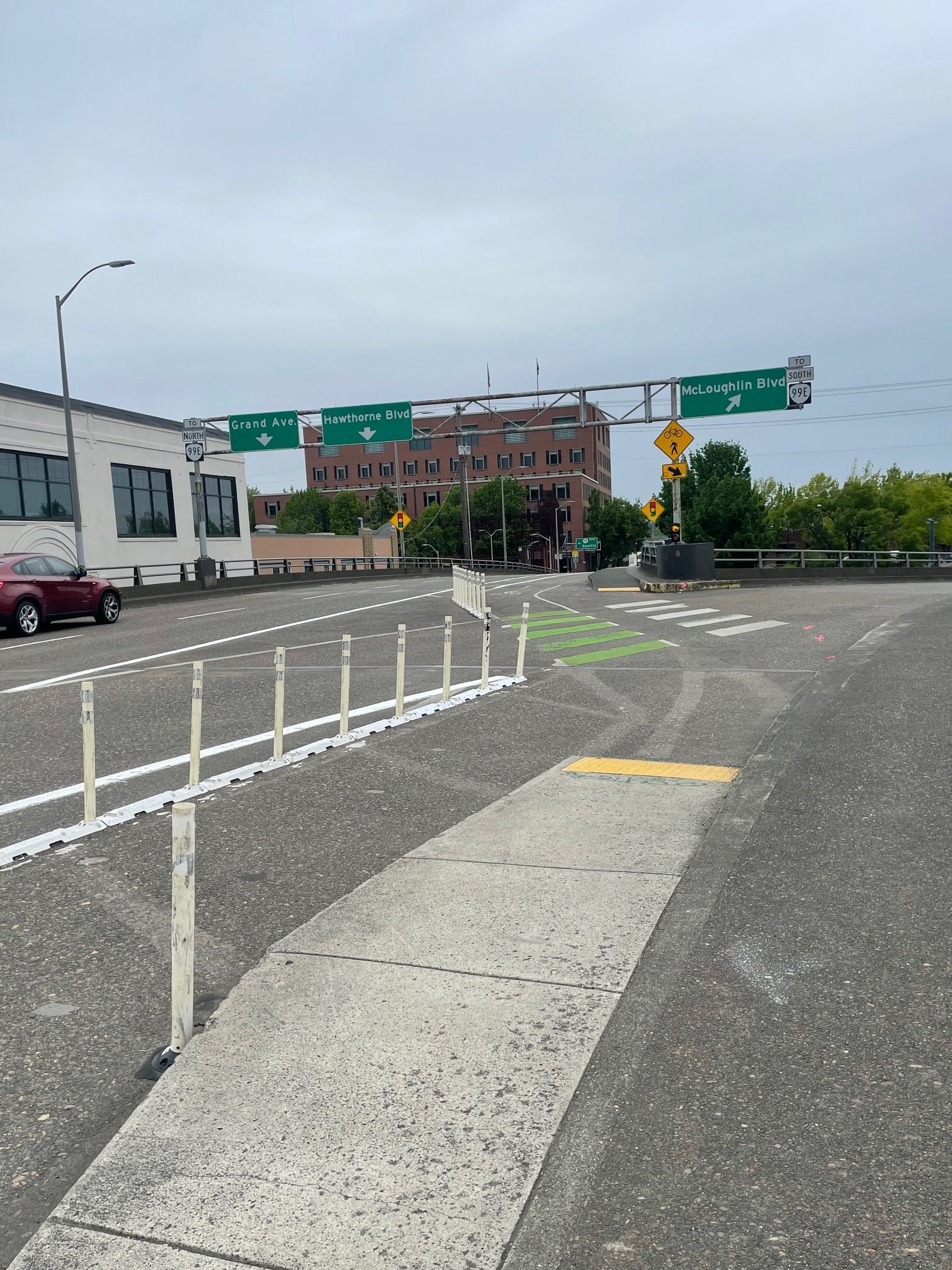
The County engineer said, “The original configuration [above left] had cyclists going into the intersection at an approximately 45° angle in which they would slow down to cross. The current configuration (installed according to plan) was intended to have cyclists actually slow down more or even stop in order to avoid situations like this.”
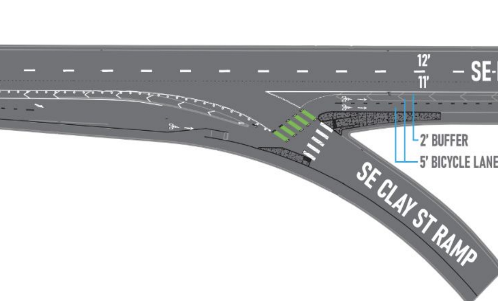
The plan the engineer refers to was shown to the Multnomah County Bicycle and Pedestrian Advisory Committee in October 2023 (see image below).
The County staffer went on to say they’ve received “a lot” of feedback about the new design, so they plan to alter the design, “to be similar to what was previously in place.” The final striping changes should already be installed and final markings should there by the end of this week.
It’s unfortunate that someone at the County felt making such a harsh angle in the bike lane — and then hoping it would slow riders down — was a good idea. Not only do designs like that usually make things worse because people don’t want to slow down, but it shows how drivers are held harmless while bike riders have to shift behavior and use irregular designs in deference to them. That is the opposite of how we should design streets. Why not alter the driving lane in a way that forces drivers to slow down and be safe?
Road authorities should never experiment on bike lanes. As we saw with this person who got hit, it only takes a bad design in place for a few hours for something serious to happen. These are people! Not a petri dish!
If anyone has an updated photo or wants to share how it looks now, please do.
The County advisory committee meets again tonight and I expect this topic to come up. I’ll report back any updates or details I learn.
UPDATE, 3:30 pm: The County has made changes to the design. See video below for current conditions. Note that green cross markings are still to come.


Thanks for reading.
BikePortland has served this community with independent community journalism since 2005. We rely on subscriptions from readers like you to survive. Your financial support is vital in keeping this valuable resource alive and well.
Please subscribe today to strengthen and expand our work.
Wow! That was an intentional design!? I’ve been thinking it was some temporary half-measure until the project is complete. How can we be more than two decades into earnestly creating bike infrastructure and still have this level of engineering incompetence?
The rider has to look far back over their shoulder to see approaching vehicles and even then the angle of view is limited. A rider could think it is clear and in the time they look back in front of them and negotiate the turn, a speeding driver can take them out. There isn’t enough room to turn a cargo bike parallel to the bridge and have a better view without entering the lane. It assumes that every driver knows that bike riders are by default crossing the lane instead of continuing down the ramp. This is such a colossal screw up. People’s, more importantly, my kid’s life is at risk here. I’m livid.
Everyone who signed off on this design should be fired.
Maybe the ramp should just be removed altogether.
I’m confused. What was previously in its place? Here’s 2009, 2012, 2014. The problem is not a radical change in design, but the existence of a freeway design for cars with a slip lane encouraging drivers to speed through the turn. There are a lot of fairly easy and efficacious fixes to this design, but “going back to what we had” is not one of them.
Someone needs to add a stop sign for the cars. The biker is going straight it should have the right of way.
I agree it’s a bit hard to see. I think the new (to be rolled back) design makes riders go a bit further down the ramp and then do a hard (almost 90 degree) left turn so that (according to the engineer) they need to stop and look. In the 2014 street view they can more or less go straight with a bit of a swerve. But also that at least gives them the opportunity to do a shoulder look more easily.
Yeah, agree with Vin and you, the slip lane is a problem. Maybe a stop sign is needed, I don’t know.
AND put the cyclists more inline to what a motorist could much easier see.
Ha, I was just checking the street views myself to figure out when the “new” ramp went in. Looks like it was sometime after 2014, as it’s in the 2016 street view. But yeah, not a whole lot of progress in that area, other than adding bollards to get people to stop cutting the corner of the off-ramp slip lane. The off-ramp “corner” should be made sharper there so vehicles have to slow down, but truck-lobby-turning-radius-freight-priority-blah-blah-blah
Except the Hawthorne bridge is not a good route for freight anyway due to the steel girders. This is just an auto centric design problem.
So if im looking at the design plan correctly…it looks like cyclists were intended to be in the turn lane (on the cars passenger side) prior to the off ramp exit? What the heck? That literally forces a person on a bicycle to cross in front of off ramp traffic at the apex of the drivers turn? And the pedestrian crossing looks like it would be in a heck of a blind spot to drivers as well. How did this ever get approved? It actually looks like a form of punishment by design. I’m really surprised no one got more seriously hurt there.
Why do they want cyclists to go slower and have a harder turn at more than 45°.
I will readily admit I am no traffic engineer but a mere pedal pusher so what do I know but my preference would be just having the bike lane continue in as straight of a line as possible. If it needs to start a crossing further back then so be it but keeping cyclists parallel with the cars the entire time would make it easier for cyclists and cars to judge who will potentially be “interacting.” Having bikes start to appear as if they’re taking the off ramp by veering to the right only to jut across traffic more abruptly seems completely idiotic to me.
Should also at the very least beef up protection around that stretch and have flashing lights that are constantly on to indicate crossing traffic.
Also, why’d the make the cyclists jog to the right when going over the new bus platform. The bike lane is headed straight for it and rather than have a straight line they make bikes swerve a bit. If there needs to be a buffer for pedestrians loading and unloading then they should have made the platform significantly larger so the bike lane could more smoothly shift off of the straight line.
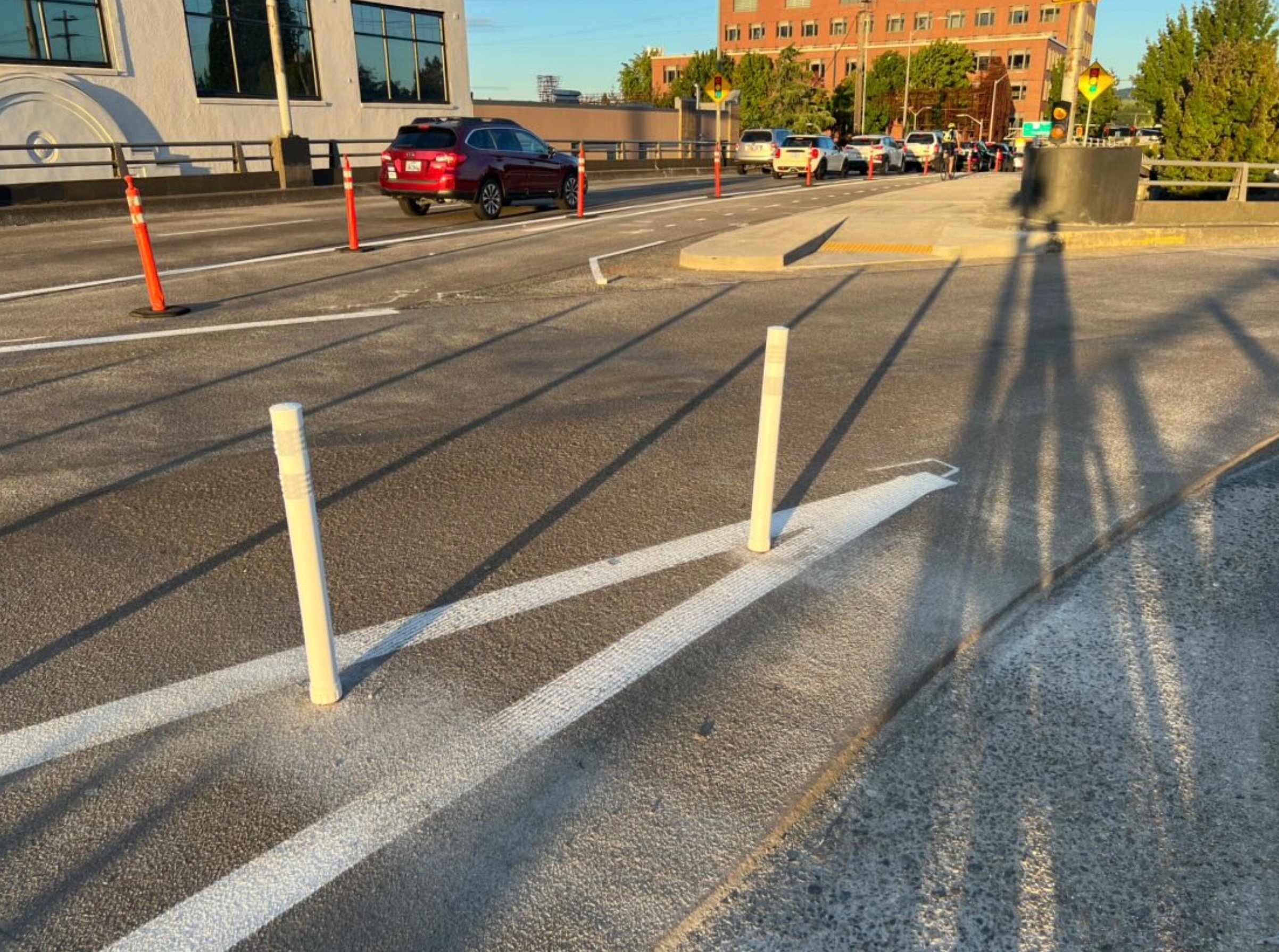
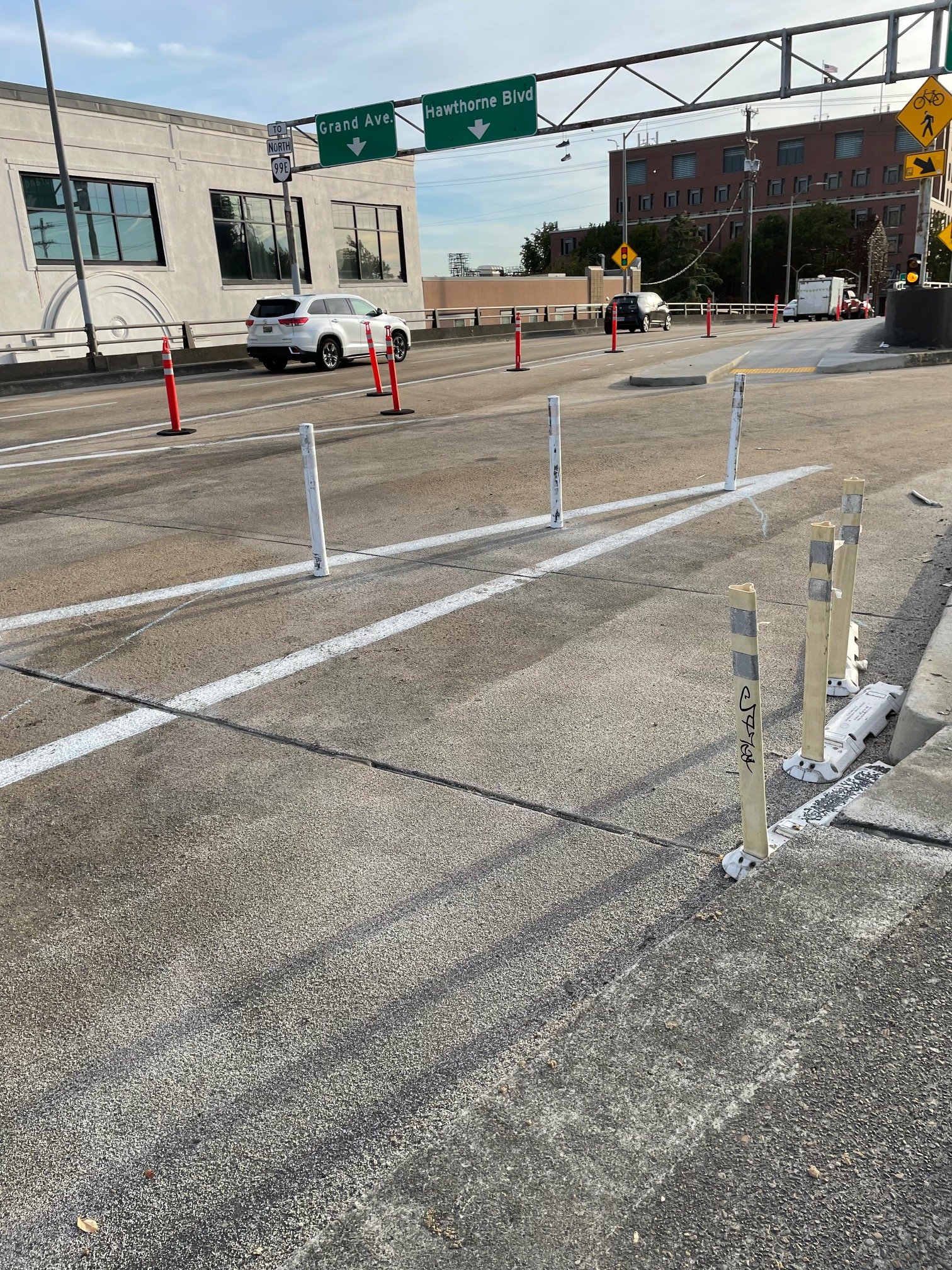
I was initially impressed they installed wands the full length of the construction zone to “protect” the bike lane but the end result is pitiful.
This is the way it was for years & felt quite safe (to me), but when they added the plastic wands ca 2015 that shortened the distance where drivers & cyclists were subtly communicating their intentions to each other. Prior to the wands cyclists would start to move left into the striped zone, with obvious intent to merge across & continue EB.
It doesn’t help that the wands themselves actually obscure cyclists
I say all this with the perspective that I bike *and* drive frequently through here. The design upgrades to EB Hawthorne from the bridge to Ladd have just made it harder to understand each others’ intentions. I still get nearly-right-hooked crossing the numbered streets, for example. I’m not a fan of “vehicular cycling” (at all) but this was one area where ambiguity & proximity increased everyone’s awareness of each other. (again: in my experience, YMMV)
Agreed axoplasm. “The design upgrades to EB Hawthorne from the bridge to Ladd have just made it harder to understand each others’ intentions.” You could say that one of the most important duties for a traffic engineer would to do just the opposite. It should be clear, based on the design, what to expect from people on the road regardless of mode. And the learning curve for new infrastructure should be really short.
If I had never seen separated bike lanes before, and only knew Hawthorne, I would think they are incredibly dangerous. As an example, This is where separation should end. But this is what it looks like. What prevents someone in a car from taking this turn at ~20 as opposed to 5-10? It’s kind of the main purpose of PBLs and it’s almost entirely absent here (and in Portland in general).
I rode through here for years – the original change was a serious downgrade to safety. This new one just took it to the next level.
I’ve been riding in between the bollards at the normal approach. It seemed like something was wrong and since they hadn’t stripped the crosswalk or crossbike I figured it was going to be fixed. I always triple check that drivers are going to stop for me here. I’ve definitely seen some close calls with other riders here and avoided some myself.
The other issue I’ve had with this new design is the bumpout with the ADA ramp on the other side intruding into where the bike lane should continue. I’ve almost hit it several times already because I’m usually more focused on drivers than a clear path ahead of me. It doesn’t seem to provide much purpose for pedestrians here. The bike lanes act as a buffer to the sidewalk so drivers are already well away from the ramp.
The original design had the bike path being elevated to be level with the sidewalk similar to how it is on the other side. The way the lane goes around the bus island is also superfluous and not how it was originally designed. I assume they did it for similar reasons to slow riders down. Overall I’m pretty disappointed in how this turned out.
This is the de facto way that bike projects tend to happen. I can think of so many newly built bike lanes/paths that insist on right angle crossing designs with the aim of slowing cyclists down. There’s the crossing of SE 7th/Tilikum Way, where cyclists get a very tight chicane rather than an offset angle for the intersection with the buses. Or the crossing of the MAX near 17th, where cyclists are forced to take a greater than 90 degree turn. Or the foot of the Blumenauer Bridge in Lloyd, where you take two turns instead of just barreling straight through at a very minor angle with the road. But it’s most often places where a bikeway is crossing a road near another intersection (like along the Springwater at Flavel/Linnwood, or at Tilikum Way/8th)
All of these are ways that designs look to slow bikes down for safety reasons – and each of them is maybe justifiable in some sense. It’s good to make sure that conflicts between pedestrians and cyclists are in places where bikes have a natural slow down point. I feel like I get frustrated when it’s in service of car traffic though – as is the case when bikeways jog out of the way for easier intersections with cars. The Hawthorne Bridge exit ramp has always been less than ideal, but I think the new design clearly shows priorities – bikes need to slow down so they don’t “hurt themselves”, while cars get off scott free. This really could have (and should have) been a raised crossing, with some kind of signal/sign telling drivers turning right to yield/stop to bikes going straight.
Yep Blum. In general, as you say it’s a good rule of thumb to get different modes slowing and looking at each other at ~90 degrees. When conflicts occur in that case they are typically minor. That’s why protected intersections are so successful when done correctly. But this can also be the “achilles heel” of design, i.e., make all non prioritized modes yield/stop to SOVs, which clearly sucks.
Ideally, the slip lane should be removed and rerouted (e.g., onto Grand>Main>MLK). But a raised crossing here (and on the West entrance to the Hawthorne) would certainly give people in cars the idea that bikes belong. The other big problems are the discrepancy in speed, and the absence of any signal re: who is supposed to yield. Even the quick redesign seen Jonathan’s vid doesn’t really address these problems (though I have to say the county’s response was quick and I appreciate that).
Crap like this drives me nuts. From the outside, it looks like road designers have a patronizing attitude with regard to bike-specific facilities in a way that I rarely see with regard to car-specific facilities. It’s like “drivers are normal people who just want to get to work quickly, but riders are fragile and must be protected from themselves.”
Designers are worried that I’m going to case it doing some kind of turn, but the greatest danger to me, based on the three crashes I’ve had, seem to be…
yep – it’s very patronizing, but it also is ultimately dangerous for cyclists. It’s natural to take a shorter/faster line when you’re riding, which often is not designed for – so you end up outside the lines and behaving “unpredictably” (from the perspective of a driver anyways).
Every place that a cyclist is forced to slow down to accommodate a car intersection, or to accommodate a perfect right turn with a bus/rail alignment, or just because an engineer thought it looked better, is a place where cycling is a less attractive option (than the straight line route would have been).
I’ve almost crashed into the telephone pole and beg button pole near the corner of 8th/Tilikum Way/Division Place more times than I can count. It’d be inexcusable if it were some ancient old system half-retrofitted for bikes, but these always draw particular ire for me since they were built in 2014. It just feels like the designers of these systems for bikes have far too little experience using them
COTW! You can add the MAX crossing, especially the crossing from the Gateway transit to the 205 path has ridiculous 90-degree turns for bikes
Add SW Beaverton Hillsdale & Bertha intersection to that list. Almost no one yields to bikes in this spot even though there’s a yield sign hidden behind some greenery PBOT refuses to trim. Portland is a car centeic city sadly.
Multnomah County government [Moderator: word substitution] screws up everything it touches
probably if you want it to be safer you should slow the cars down?
The slip lane ought to be eliminated.
The entire car ramp onto MLK is highly redundant and unnecessary. Car enthusiasts already have the option to drop down to Water, turn left on Grand, or continue straight onto Hawthorne.
My guess is the slip lane was originally part of the bridge design when it was for trolleys (pre-1920) and the lane was used for allowing trolleys to turn on or off the line on Union Street (now MLK). Cars don’t need such a wide radii. The city/ODOT/Multnomah County have already eliminated several other trolley slip lanes downtown, this one is clearly overdue.
If you look at the aerials it was put in between 1955 and 1960. This has Robert Moses stink all over it. Probably wanted to turn McLoughlin into an East Side freeway connecting to I5.
If they eliminated this ramp and the cloverleaf just NE of it, that would be 1.5 city blocks worth of land that could be developed and bringing in tax revenue.
Highways kill cities.
If it is from the 1950s, then the concrete may be crumbling (a notorious feature of 1950s concrete nationwide) and the viaduct may be slated for replacement (or demolition) within the next 20 years anyway, as soon as funding can be secured, likely on the 32nd of never.
Not when there’s a freight train blocking the way. That’s (probably) the reason there’s a viaduct there in the first place.
If there’s a train, they can take a left on Grand and another left to get to MLK.
What kind of surface street improvements would be needed to make that work?
This would be a great spot for a bicycle signal like on the west end of the bridge.
I would not want to be forced stop there. A “cars yield” is the right affordance; the question is how to reinforce that with a sane design.
Yeah, hard no on the bike signal. Cars should absolutely have to stop here. They also have a potential hard stop at the bottom of the ramp at Clay St anyway. At the speeds people take the ramp, it’s incredibly dangerous for the intersection at Clay.
As far as sane designs go, there’s actually a decent amount of space to work with, including a lot of dead space in the buffer between the slip lane and the bike lane. I think you could add a dedicated right turn lane without having to significantly reduce the size of the bike lane. Add a stop sign before the bike lane and some flexy posts to direct cars into the turn lane and cut off fast angles. I’d happily take the reduction in bike lane size here to make crossing the slip lane safer.
Also, the speed limit on this section looks to be 30mph, but the design invites MUCH faster travel. Maybe also put a speed camera close to the ramp, since other traffic calming may not be practical on the viaduct.
Not bad Andrew. Pretty low cost too. I’d prefer ramp removal, but this seems doable. Narrower traffic lanes would also tend to reduce speed.
Thanks. The ramp will need repair someday, at which point demolition may be the preferred cost option. Hopefully by then we (the royal we) can honestly say that the ramp is no longer needed. Honestly, I think there are currently enough people who drive this route out of town on 99E that I’d really rather not redirect them to surface streets, as this can make that environment suck for everyone (example: getting onto the H1 from McCully St in Honolulu. If you’ve never experienced this area at rush hour in a car, on a bike, on foot, or on Da Bus, good for you).
I think for the time being there are some pretty good low-cost options. We just need to not give broad deference to car traffic if we want the design to be safe.
Even more locally, just getting from I-5 to the Ross Island Bridge, or between 26 and the Ross Island Bridge, or anything related to the Ross Island Bridge, actually.
THIS IS THE WAY
This would be great. One of the deficiencies of the current design is that it is impossible to tell if a car is going to turn or go straight. Road design should make it clear who has priority and what everyones intentions are.
COTW nomination.
It might be a decent place for automatically activated flashing amber lights overhead and embedded in the roadway (to supplement green paint). Unfortunately this would cost real money and require detailed planning with serious consideration for cyclist safety before they started the project.
I always take the “car” lane prior to reaching the off ramp exit.
Feels awkward and unsafe to use the bike lane there.
I’m having trouble visualizing this change. How did it make it more likely for bikes to be hit?
The initial redesign created a sharper angle, thinking that it would force riders to slow down. But the unnatural design only created less predictable movements and created less visibility of drivers by bike riders.
I ride that stretch all the time. They honestly just need to close the ramp. Slightly faster access for cars onto MLK doesn’t justify that level of danger
Multnomah county should get rid of this dangerous and unnecessary ramp and build very low income housing in the three newly available lots.
https://www.portlandmaps.com/detail/property/-13654753.6452_5702509.31878_xy/
Heck yeah!
That’s my reaction as well — this is just such a striking example of engineers / designers spending a lot of effort to come up with what amounts to a still suboptimal, dangerous design for people on bikes so that they can keep the off-ramp. The obvious and straightforward solution would be to close the ramp. All of these slip lanes really need to go, they are unnecessary and dangerous.
I rode through this twice last week. The first time I just continued through the wands (those ain’t gonna last) on the same vector that sort of worked on the previous design. The second time I followed the new intended pattern and had a serious WTF moment as the drivers coming down the ramp behind me apparently did not expect me to stop and turn. And then there’s that weird extra carb that I had to dodge at the last moment. My companions and I left the scene shaking our heads at yet another boneheaded experiment on one of the city’s busiest bikeways.
I had a really similar experience on the day that I “tried out” the new design
Classic, an engineer who probably doesn’t ride a bike ever making choices that prioritize cars. The bikes don’t need to slow down here, the cars do!
I appreciate the quick change, but still wonder why a stop, or yield sign (either for cars or bikes – though I’d prefer for cars!) isn’t also present.
Outrageous for all the reasons Jonathan stated. If they really want to make that area safer, how about speed bumps in the car lane?
This conflict is so sad because the whole area is otherwise pretty good for bikes and when you arrive here, it feels like the planners just threw their hands in the air and gave up. It’s very dangerous and I actively avoid this bridge when possible currently.
Oh, whoops, for a second I thought you were talking about the future bike lanes that will just end at Halsey and 92nd and force people to cross 4 lanes of road to ride over 205 on the overpass sidewalk. Hmmm, I guess these planners really do like to throw their hands in the air like they just don’t care.
Who has the right-of-way? I’m guessing the cars, since the bike lane users are crossing? In the video, it looked like neither the driver or the scooter rider was sure. Scary. It only works if one or both assume they DON’T have it, every single time it’s used.
No – the bikelane is a through lane, the cars are crossing it. Just like every other right turn across a marked bikelane the cyclist has the right of way.
Under the new design, the bikes are diverted right along the offramp, and they themselves cross the car lane which, at that point is essentially “going straight”.
So it’s not really clear. That’s one reason the new design sucks.
I totally agree with the sentiment but I can’t even imagine the poor souls who are faced with convincing a cop or judge of that fact. Maybe I need to get one of those 360 cams for my commuter.
It doesn’t look like a through lane. It looks like a bike lane crossing a vehicle lane. The cars have already turned.
MultCo continues to be the most actively hostile transportation agency to cyclists of any of the major local agencies that I’m familiar with (Portland, ODOT, MultCo, WashCo, Beaverton, and Hillsboro). Between egregious roads with no shoulders — Skyline, Scholls Ferry, etc. immediately come to mind — and situations like this, MultCo is the biggest impediment towards achieving more cycling road share throughout the region.
Everybody who designed or signed off on this design should be fired. That’s a dangerous level of incompetence (to be generous) or malice (to be ungenerous).
Who does the county say has the right of way here? The cars are taking an exit and crossing the bike lane which is going straight in an uninterrupted path (in theory at least). As a cyclist and driver on this stretch I have always assumed that bikes have the right of way. I understand the green zebras are meaningless but yet I’ve always interpreted the situation as cars crossing and having to yield to cyclists.
The intention of the former new plan that’s since been adjusted seems to imply the county intended bikes to yield to cars here though?
Will be interested to see if any yield signs, flashers, etc. are put in here. It’s a tragedy and lawsuit waiting to happen in its old, recent, and currently updated forms.
That’s why I also asked who has the right-of-way. It seems like the County isn’t realizing the legal implications of its designs.
If the bike lane didn’t bend at all, and just continued straight across the top of the vehicle ramp, it would be a standard situation where a driver is turning across the vehicle lane and must yield to bikers.
The “former new plan” pretty clearly reversed the r.o.w. situation, so bikers are now crossing a lane, so must yield to cars.
The newest configuration has some benefits over the former new plan, but by being halfway between a straight bike lane and a bike crossing, seems completely ambiguous in regard to who has the r.o.w.
In many ways–as a driver or a biker–I think a simple straight bike lane (along with a TURNING VEHICLES YIELD TO BIKES sign) would have been best.
Yeah, just wow. If I had encountered this on my daily commute, I’d ignore the “infrastructure”, stay as far to the left as I could and continued straight after doing multiple head checks for turning drivers. Which is what I did during the decade I used that bridge daily.
Before the recent fix, I saw most cyclists continuing onto the sidewalk after crossing the rank to MLK instead of making the intended 90 degree turn to stay in the bike lane. What a boneheaded design choice.
I hadn’t ridden this in a while, and went through it a week and a half ago. It was a major WTF moment when I saw the wands that practically close off the previous route. I ended up weaving through the wands. Only after making it through did I realize that this was an intentional obstacle!
We will never make it to 25% bike mode share if we continue to put literal obstacles in bike riders’ way.
I’m just a pedestrian who crosses there 3-4 times a week and believe me it is worse than what was there before. Hard to believe professionals came up with that.
This situation is almost identical to one on SW Bertha Blvd in 2021:
https://bikeportland.org/2021/09/27/first-look-city-restripes-bikeway-at-busy-sw-bertha-beaverton-hillsdale-highway-intersection-338709
In that one, PBOT took a bike lane that continued straight across the top of the vehicle turn area, and rerouted it so bikes crossed the vehicle lane where vehicles were already in mid-turn.
Several people pointed out the problems with that (very similar to problems people are pointing out with this one), and PBOT responded (in the article) that a “forthcoming addition of bicycle “detection and advanced activated warning lights”” would fix all that. Three years later, whatever that was going to be has never shown up.
So two questions for PBOT–if that detection and light system wasn’t imaginary, 1) why wasn’t it ever installed on Bertha, and 2) why not do that (installing it, not promising it and then forgetting) in this location?
The redesign is the bane of my existence. Most drivers from Bertha turning onto BH Hwy stop beyond the stop sign, and then almost no one yields when turning. Drivers here should be forced to negotiate a 90 degree right turn, but instead PBOT decided to preserve the slip lane nature of this design.
Wow! I haven’t ridden that nor knew about it. Very similar situation with a bike lane going straight and cars turning ACROSS the bike lane. The only difference is this situation there is a full turn lane for cars that extends way back, likely difficult to incorporate on the limited footprint of the bridge (still doable IMO though). Despite that insanely long turn lane they still made the bike lane jog and create an ambiguous ROW situation. Engineers always just see bikes as able to ride around in circles in the gutter if need be but vehicles with their motors and premium road choice must never been forced to divert from as straight of a path as possible.
I’m glad you shared this, as I was just thinking about the same area. I think Bertha was more successful than Hawthorne as the cars are forced to make a tighter turn which slows them down. However, one would hope that PBOT would have learned from the issues at Bertha, and come up with something better for Hawthorne, instead of something even worse.
Except Hawthorne isn’t PBOT, it’s County plus likely ODOT guidance.
I made that mistake when I posted the Bertha example, which probably misled MontyP. But their point can just be revised–one would hope that the several transportation agencies operating here would learn from one another’s mistakes.
Exactly. I can’t believe they (insert whatever agency/s are responsible for this) didn’t think “Hmm, is there any similar roadway in the PDX area that’s had bike lanes added to it? Is there any project we can learn from?”
Learn? In Portland?!?
Oh no, Portland doesn’t do that sort of thing.
Instead, a new stakeholder advisory committee needs to be formed, the Hawthorne Bridge Clay Street Ramp Stakeholder Design Advisory Committee – the HBCSSDAC – made up of one member appointed by each of Portland’s 12 new city councilors, the new mayor, the new City Administrator, five from the County Commission, one from Metro, another from ODOT, one from TriMet, one from USDOT – 23 in total. They’ll meet monthly over the next 5 years, at 10 am every 2nd Tuesday at the County Building across the street. At least once per year they’ll all go on fact-finding field trips to Amsterdam, to see how they do such fixes, see what works, etc.
I was just in Amsterdam two weeks ago, and it was amazing to bike around. I wish more road planners/engineers could go there and bike around and “get it” so they don’t keep coming up with these crummy designs.
Our chief city traffic engineer here in Greensboro who was notorious for designing stroads that made cycling pure hell, once spent 3 weeks in the UK at a local city re-learning his trade on a sponsored junket, back in 2018. When he came back, he suddenly started designing bike facilities that were innovative and actually safe and useful – he’s still at it, but his employees still “don’t get it” and keep designing crap. It would be a great use of our highway funding to send all our city and public engineers to Europe to be “re-educated”, to borrow a communist term from the 70s.
Ha, was just thinking the same! It did slow down car drivers turning right from BH Hwy, but made it so much worse where car drivers turn left from Bertha to BH Hwy!
Oops, I forgot PBOT only did the poor Bertha project, and it was the County that did the poor bridge project. The question remains though–if PBOT thought the Bertha project needed detection and lights to be safe, why does the County feel their similar design doesn’t, especially when the cars on the bridge are going much faster than the cars on Bertha?
Workarounds like this remind the cyclist that few, maybe no concessions are made for cyclists. The parallel universes imagined by traffic engineers end up colliding. We can do better and yes, bicycling should be made safer, and driving a little less convenient.
Is Portland going to embrace bicycling as an alternative to the automobile? Now is a good time to ask.
Most “design” in Portland is a total waste of time. Portland absolutely loves nannyish paint, lights, and wands everywhere — which are systematically ignored by everyone.
Consider the much ballyhooed Better Naito. Paint and lights everywhere which hardly anyone pays any attention to — the area is a free for all. Or the growing number of areas around town where the car lane is supposed to meander around but the paint guidance is ignored (when it isn’t totally invisible under poor visibility conditions).
I used to ride this particular section every day. It never was a big deal, and frankly I feel a lot safer in a “mixing zone” than in a short conflict area even if the speeds in the former are significantly higher. This feels like Interstate and Larrabee where some stupid principle of minimizing the conflict area rather than dealing with the reality of how both vehicles and cycles behave
AKA Vehicular Cycling:
Designing safe streets is a waste of time.
My feelings are as important as actual evidence.
Everyone believes the same thing I do.
I always feel safe with cars.
People who don’t need to get over it.
Is it really this bad or is BikePortland being sensational? My gut is telling me the former.
The bridge wasn’t two terrible maybe a dozen years ago. Then it got upgraded. Funny how one tweak to the upgrade managed to undo the whole thing, even make it something worse!
It really is that bad. The new design makes drivers think they don’t have to yield.
But do they have to yield?
100% drivers must yield.
There is no ambiguity.
People driving are changing lanes/turning right.
People riding bicycles are continuing forward.
People riding bicycles have the right of way at this location.
There’s definitely ambiguity. In the video, the driver and scooter rider BOTH yielded. Several people have also commented that it’s not clear, and people commenting here generally know the applicable regulations well.
Are you confident that drivers know to yield? I’m not. I’m not even confident a cop, judge or insurance company would agree that drivers must yield. Even if a legal analysis shows that drivers must yield, that doesn’t mean much if you happen to be crossing in front of a driver who doesn’t know they must yield.
Maybe. Maybe not. You can also make the case that they’ve already turned. And they’re definitely NOT changing lanes as they cross the bike crossing.
Sort of, sort of not. They’re certainly not going straight–they’re turning left. If you didn’t turn your wheel, you’d head into the ramp–the video makes that clear. From a driver’s view, it also looks like a bike that’s “continuing forward” would head down the exit ramp. In fact, that’s what the yellow sign is telling them–it shows a bike, with an arrow pointing right, down the ramp. The sign is telling drivers that bikes are going right and down the ramp, not going east on the bridge.
That could very well be true. But it’s ambiguous, which makes it dangerous.
By the way, if this were a standard situation where the bike lane was going straight, and cars were turning right across it, I’d agree with you–no ambiguity that the bike rider has the right-of-way.
Not in the new design; now drivers turn right before intersecting with the path of the cyclists, with the bike path turning alongside the traffic lane. The cyclists could be seen as being the ones changing lanes in order to turn left.
The situation is dangerous in part because it has become ambiguous.
Force the vulnerable user *WITH THE RIGHT OF WAY* to slow down and even stop?
ARE YOU KIDDING?
TO THE MORON TRAFFIC ENGINEER – YOU MAKE THE FREAKIN HUGE DEATH MACHINE CROSSING A LANE OF TRAFFIC SLOW DOWN AND EVEN STOP.
You know, just when I thought my opinion of US “traffic” engineers had reached it’s nadir, something like this happens.
Is there no huge “yield” sign for those turning right?
mh this is one of the problems with the design. There is some ambiguity re who must yield. There are two signs that indicate the existence of bikes and people walking, but aren’t explicit about who is required to yield.
Still a horrible design after the changes. The county should have recognized that this intersection was problematic to begin with and they should have worked to improve this dangerous conflict instead of worsening it.
Why not have the bikes go straight and clear indicators that cars yield to turn right?
Is the engineer unaware of the large A-pillars in some vehicles that create blindspots for bikes and pads?
Is the engineer unaware that some drivers will take the slip lane at speed assuming they have the right of way?
Is the engineer unaware that some drivers don’t realize that bikes and peds pretty much never take the off-ramp down to MLK.
Is the engineer unaware that car traffic can slow enough for bikes to catch up to cars, and drivers will often not look back before turning right? And this is more dangerous when the car doesn’t slow for the turn.
The entire purpose of this dangerous design is to prevent cars going straight from having to slow down for right turning cars. This is a “drive at your pleasure”/ “bike & walk at your own risk” design. Drivers will speed because it feels good to them, but the time saved rushing to the red lights they encounter on Hawthorne, MLK or Grand is nonexistent.
Does the county do this in-house or do they contract out these projects?
Based on these planning documents the design was by Jacobs and PBOT. The county website about this project is very vague about who is doing the work or if they contracted with any other engineering firm for the construction phase.
I don’t recall the name of the construction vehicles I saw out there but I definitely don’t remember seeing any engineering trucks. Considering most of the work was done at night I suppose that’s not surprising.
Jeez, looking at the plan it’s clear that whoever implemented the plan clearly never read the plan. (I’m assuming it just got watered way down after a few back and forths) It shows a raised bike path at sidewalk level, less severe jolt to the right at the bus platform, the raised path continuing all of the way to the crossing, and a new signal at the crossing!!! (unclear what the signal would be indicating though, cars or bikes forced to stop/yield).
If cars are supposed to yield here then why don’t they have the yield triangles painted on the road like the SW Bertha example posted elsewhere in the comments. Inclined to believe that the engineers believe this is a bikes need to yield and stop situation but neither is clear and either encourage both users to go straight into each other. We all know who wins that collision.
those planning documents call fora signal at this location
I can’t get these documents to actually load. I’m very curious if this is a case of poor execution, or poor design. Especially with the business about the bus platform making the bike lane jog around.
Reminds me of the weird bikelane design on the intersection of BH Hwy and Bertha (car drivers turning right, bicyclists going straight). While it did slow down car drivers turning right, they are still often surprised to see bicyclists because the bikelane comes so late in the turn. But even worse is that most care drivers coming from Bertha turning left on BH Hwy come to a stop in the middle of the bikelane where they can’t see bicyclists very well that come in a weird angle. Plus car drivers are focused on far away car traffic, not bicyclists right in front of them. Doesn’t help that people think that it’s enough if the first car comes to a full stop and the rest can just follow behind when there is a gap in traffic… I vaguely remember being promised flashing lights when bicyclists approach, but that must have fallen off the truck…
It IS like Bertha–probably even worse–and you’re right about all the problems, and the promised lights. Scroll up to my comment with the photo, and the responses, and you’ll see lots of people agree with you.
The yield to bikes and pedestrian sign needs to move, it looks mostly invisible to the car traffic at the existing location and angle. It should move off the curb out just before the slip lane and the bike lane intersect.
I rode over that part for a couple years before the office moved and I rarely (if ever) noticed a problem. Now that I drive over that part most days, it just looks massively foolish, & dare I say stupid.
The major problem I see, is that the cross traffic (bikes) are too far down the throat of the turn & the car/motorists too want to not slow down when they turn & don’t see (i.e. don’t LOOK to see) if there is anyone else near who might cross their path (which is an all too common human failing).
But then I’m not a traffic engineer & am only working on layman’s logic, so maybe I’m wrong… But I doubt it.
ugh
The clay street ramp is a terrible piece of infrastructure and should be demolished or at a minimum closed to cars. If they continue to allow cars to use it, tehy need some bold signage indicating “CARS YIELD TO BIKES” maybe painted on the road ahead of the intersection. I think a signal and dedicated right-turn lane for cars might be a good option, but really, the best idea for safety and urban planning is simply to close and demolish the ramp
We need to demand that cyclists, pedestrians and transit users are prioritized. Yes,above motorists. Cars have gas and brake pedals, stopping is easy. Not so for other road users.
Spots like this and many others across the city need to force cars to stop, especially when bikes are going straight and have the right of way.
Do they even live in or have been to Portland? Do they realize that Hawthorne is one of 3 essential biking and walking connections? Do they understand that this should be 8-80 infrastructure that can work for tourists who just rented a scooter or BIKETOWN and want to head over from their hotel to an east side restaurant with the expectation that Portland is bikeable? Do they realize that there are 4 massive highways dedicated to cars and trucks that cross the river just next to the bridge? This is such a wasted opportunity already, and this screw up just shows how inadequate the county’s understanding of this bridge is.
What would we think about infrastructure for cars designed by a non-driver? It’s just as insane to think that a traffic engineer who (obviously) has no idea how a cyclist experiences the road can create usable and safe bicycle infrastructure.
Cars in a narrow debris-filled gutter car lane and bikes in all the other lanes!
That is the dream
I went through this new (now old) configuration a couple of times:
The fundamental issue here is that forcing bikes to cross at a 90 degree angle would only make sense from an engineering perspective if this were a signalized slip lane that was activated by bikes, in other words bikes would roll up, pivot to 90 degrees from traffic, fully stop, activate the signal, then go. Trying to do this without a signal might make sense for pedestrians who naturally will stop, wait for a gap, then cross. But cyclists can’t be expected to make a hard pivot while in motion, turn their head, and cross, and drivers would never be expected to think this bike lane is about to cross the slip lane since it looks like the bike lane is continuing down the ramp, and bikes are not pedestrians. The 45-degree (ish) angle is far more appropriate in this context, and it is pretty surprising that any engineer thought this was a good idea.