
(Photos: J. Maus/BikePortland)
The Portland Bureau of Transportation is very busy right now. In my 15 years covering the agency, I’ve never seen them so flush with cash or have so many projects going on all at once. The combination of new funding sources at the state (House Bill 2017) and local (Fixing our Streets gas tax increase, $50 million “Build Portland” fund) levels, combined with dozens of real estate development projects (that come with System Development Charges and Local Improvement Districts) has led to a dizzying array of changes to streets citywide.
I rode around the central city Monday morning to take a closer look at several of them. I observed and photographed in-progress and completed infrastructure updates on: North Rosa Parks Way, North Vancouver and Fremont, Northwest Front, Northwest Thurman and 20th, West Burnside at 18th/19th, Southwest Main, the Burnside Bridge, Northeast Grand, and North Greeley. Here’s what I saw:
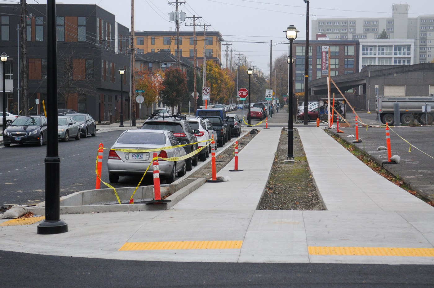
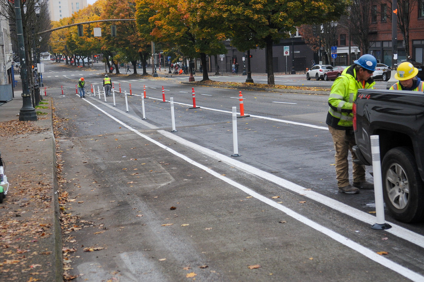
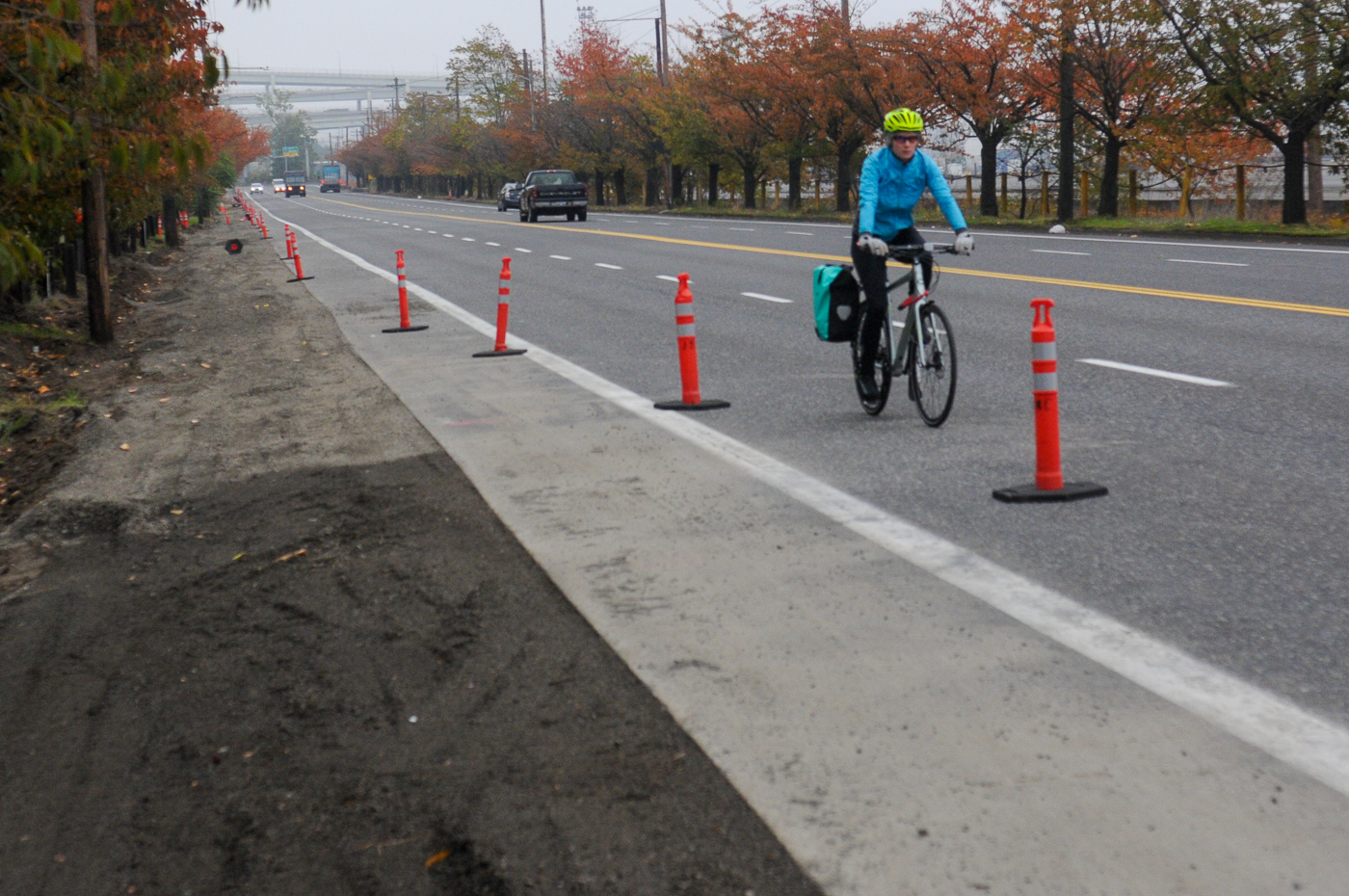
North Rosa Parks Way


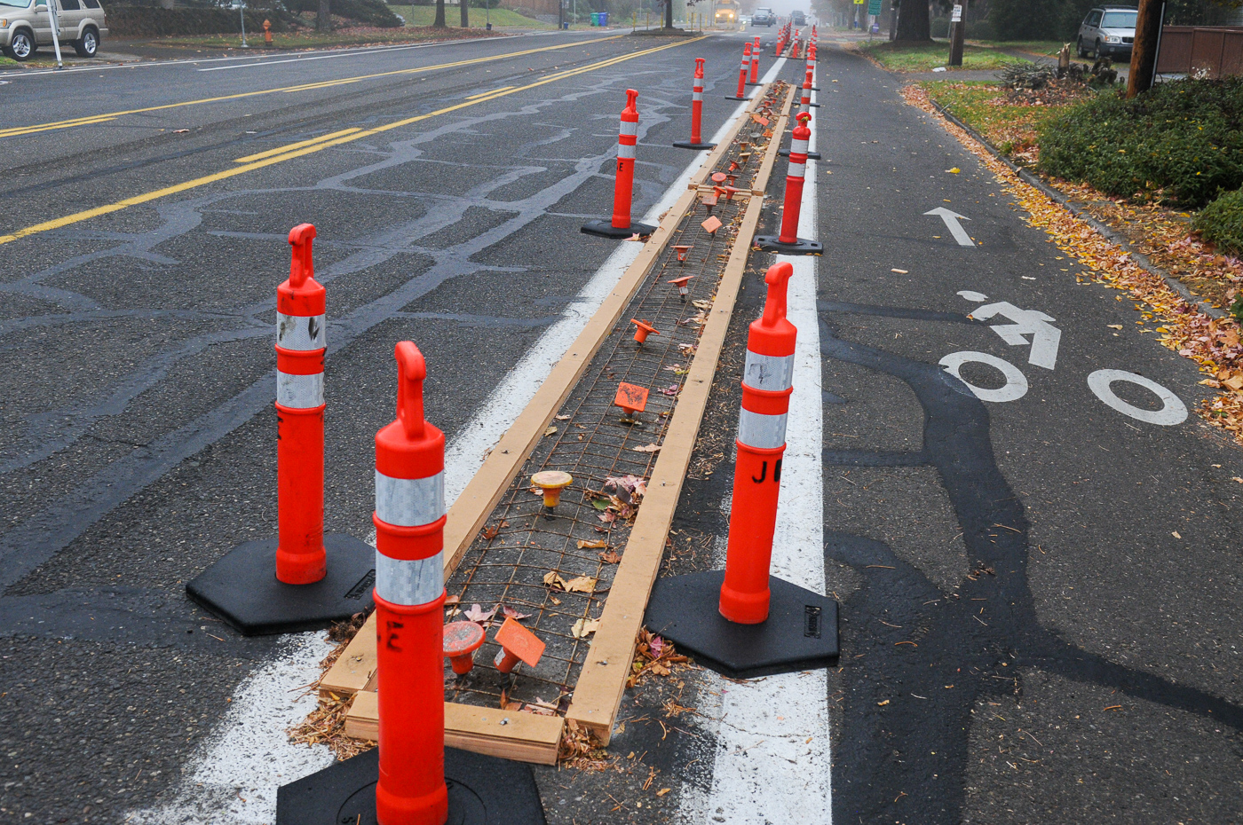
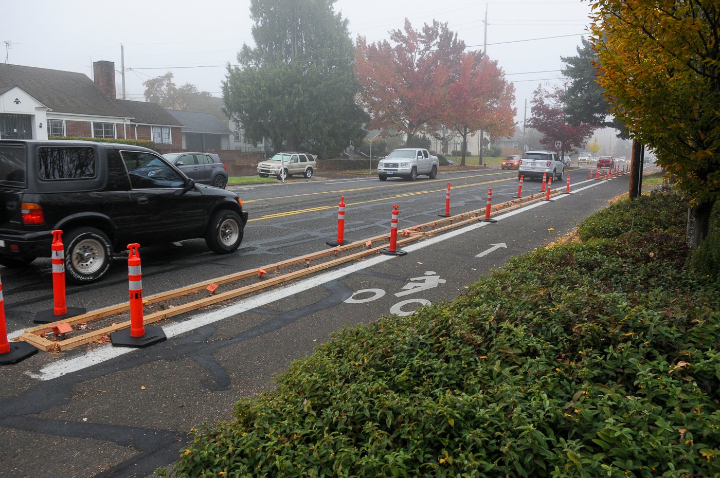
The concrete curbs we’ve waited on for over a year are finally coming. PBOT has installed the forms for the curbs on the north side of the street between NE Martin Luther King Jr. Blvd and Williams. There are stencils painted in other locations. This will be a major upgrade to the existing bikeway that was installed with plastic delineator wands at only a few conflict points.
Once PBOT is done with this we will the new curbs at ever section between MLK and Willamette — except where there are turning lanes, bus stops, driveways, and parking spots (only a few spots curbside at Arbor Lodge Coffee). The other gaping, unprotected hole in this bikeway will be the overpass of I-5. Why? Because ODOT prioritizes auto users over everything else. Not only have they narrowed the bike lane PBOT recently put in, but they won’t let PBOT install the curbs on their right-of-way.


Further west on Rosa Parks PBOT has installed plastic curbs and plastic delineator wands at the curve onto Willamette Blvd. This location was highlighted in a #RedCupProject event organized by Sam Balto and Reed Buterbaugh back in April because so many drivers dive into the bike lane at high speeds. At first look, the new curbs are doing an amazing job of slowing people down. Let’s see how long it takes before 1) all the wands are destroyed and/or 2) PBOT gets so many complaints they remove them.
Advertisement
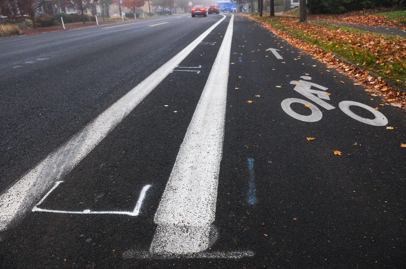
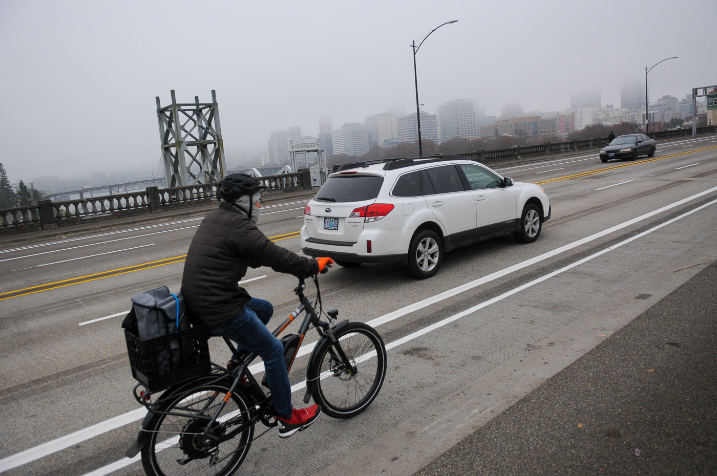
North Vancouver


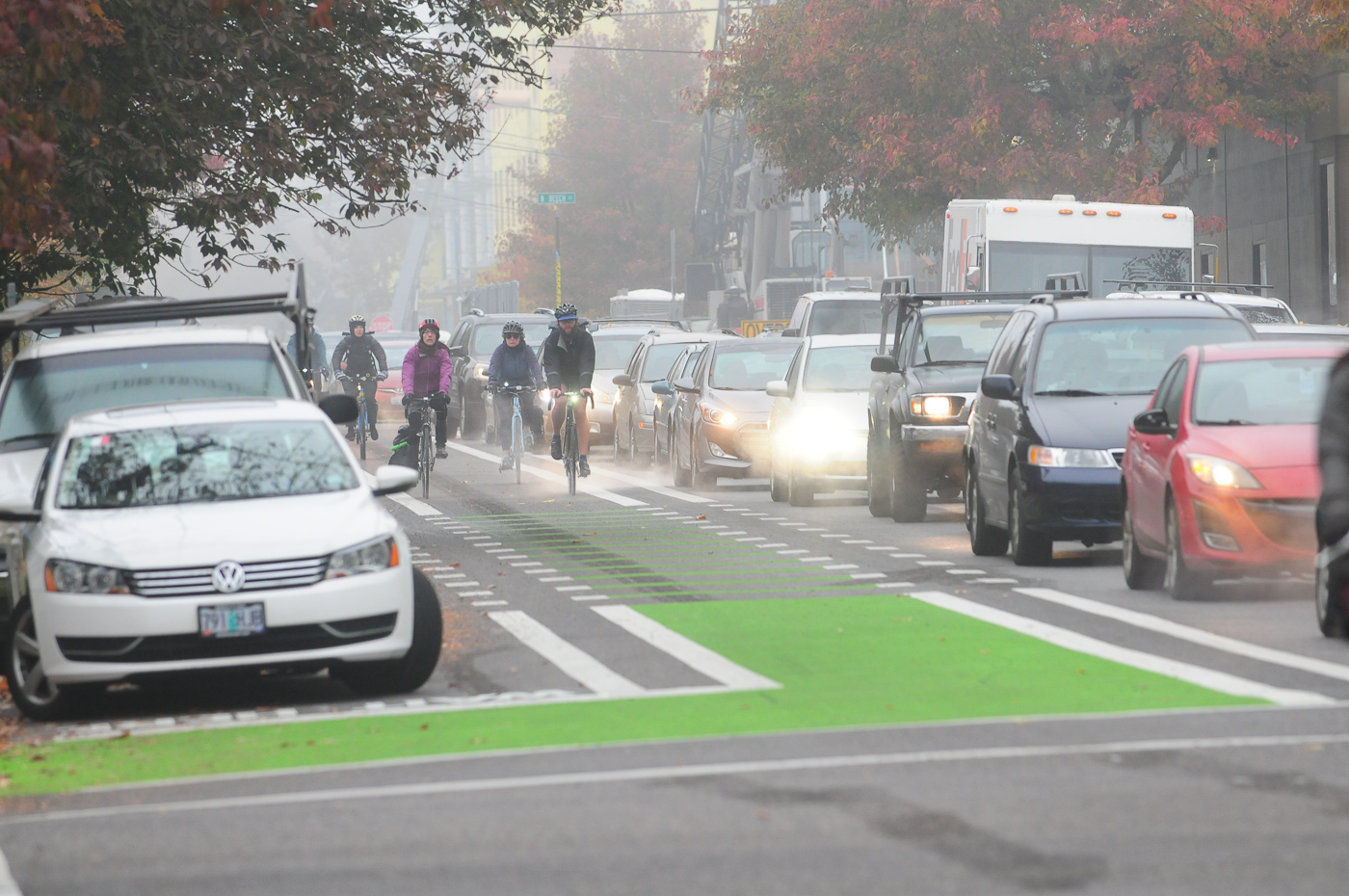
PBOT has finished a lane re-striping project on two blocks of Vancouver north of Fremont. This is a very busy bicycling route in a fast-growing part of the city. As I shared last month, it’s very heartening to see bike lanes get wider as an area gets more crowded. The new bikeway between N Beech and Cook give bicycle users more room to operate. The green coloring approaching Fremont defines the cycling space and there’s a new bike box at the intersection.

Unfortunately, south of Fremont the stress ratchets back up as the dreaded weave has yet to be solved. This morning I saw a very dangerous double-weave situation when someone tried to drive eastward across bike traffic at the same moment someone cut over to make the right turn at Cook. We need safe, protected bikeways along the entire Vancouver/Williams couplet! This is a cycling arterial that should be treated with as much respect as we treat driving-centric couplets like MLK/Grand.
Northwest Front
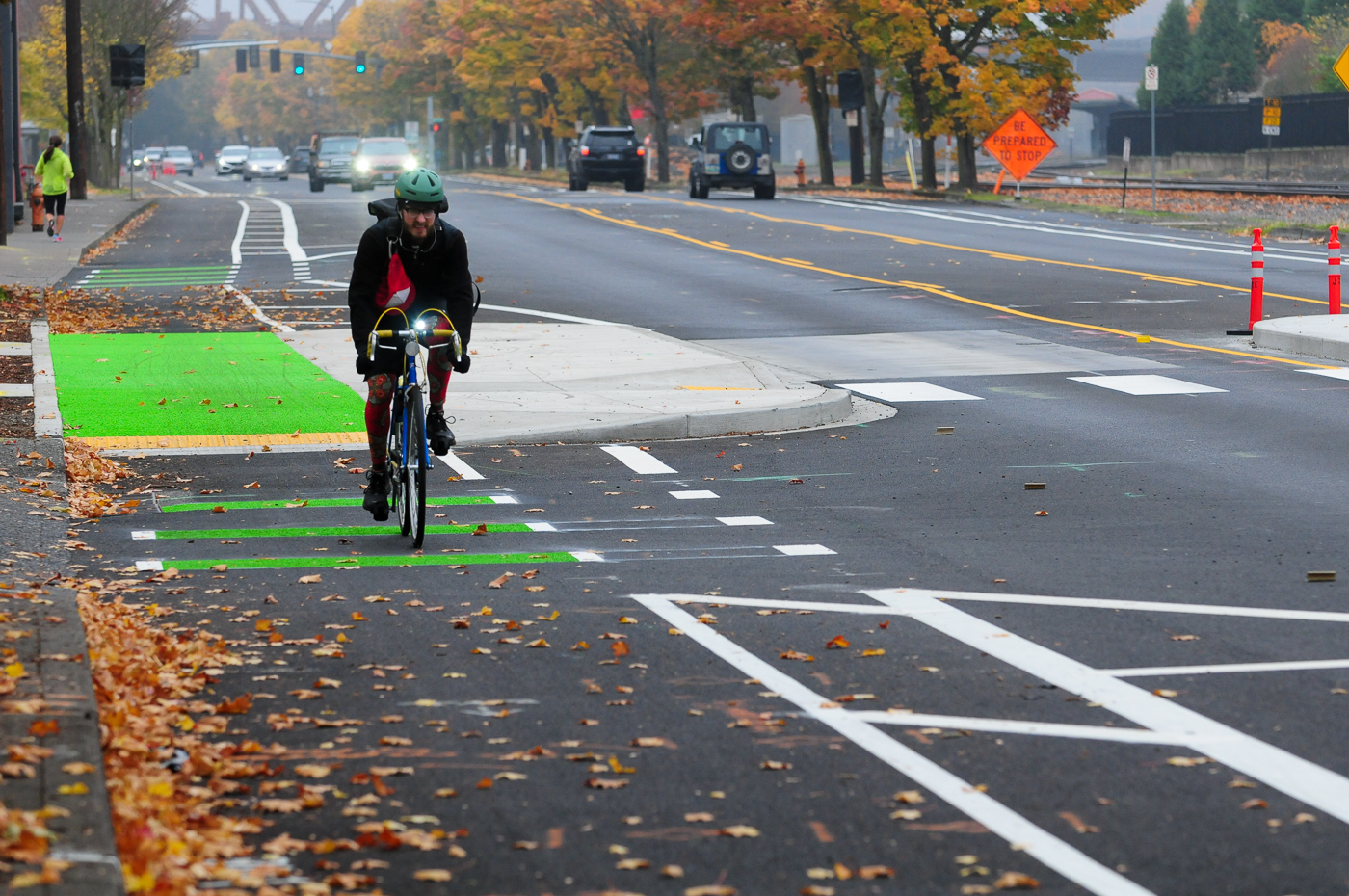

We finally have bike lanes on NW Front between 15th and 9th! As I previewed at last month, this gap between two dense parts of the city is now fully closed with the addition of bike lanes in both directions. There’s no physical protection on the bike lanes except for where they go behind transit stops outside an office complex about halfway between the two streets.


North of 15th, PBOT hasn’t finished striping bike lanes outside of the new Field office building (you might recall the owner of that building ponied up for their own Biketown station in 2018). At NW 17th and Front PBOT has installed a large curb extension which doubles as a transit island and has the bike lane running behind it. Hopefully PBOT figures out the striping outside the Field Office building soon so we have a continuous (mostly high-quality) bikeway between NW 17th and the Hawthorne Bridge.
Advertisement
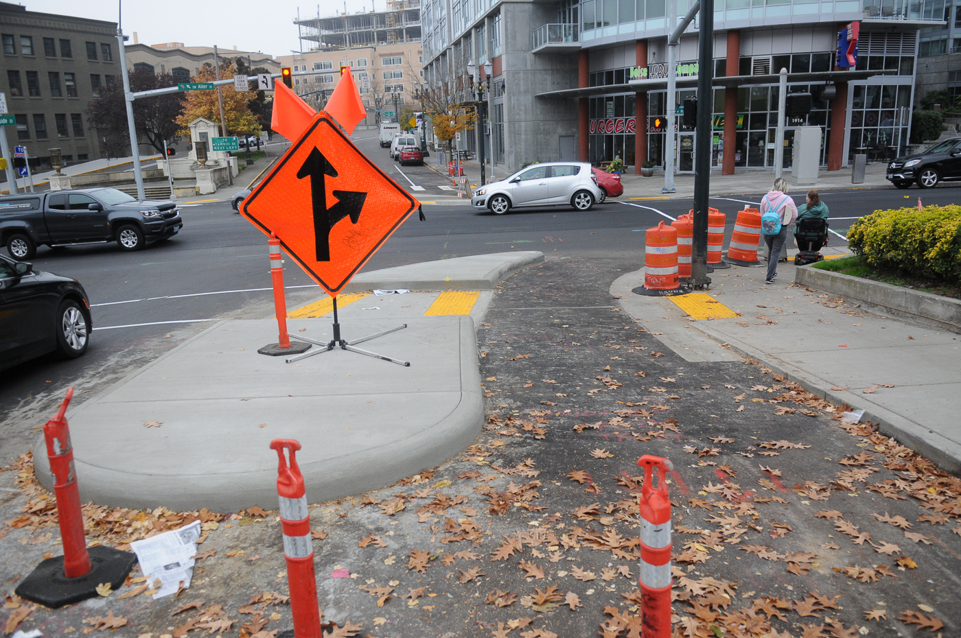
Northwest Thurman and 20th
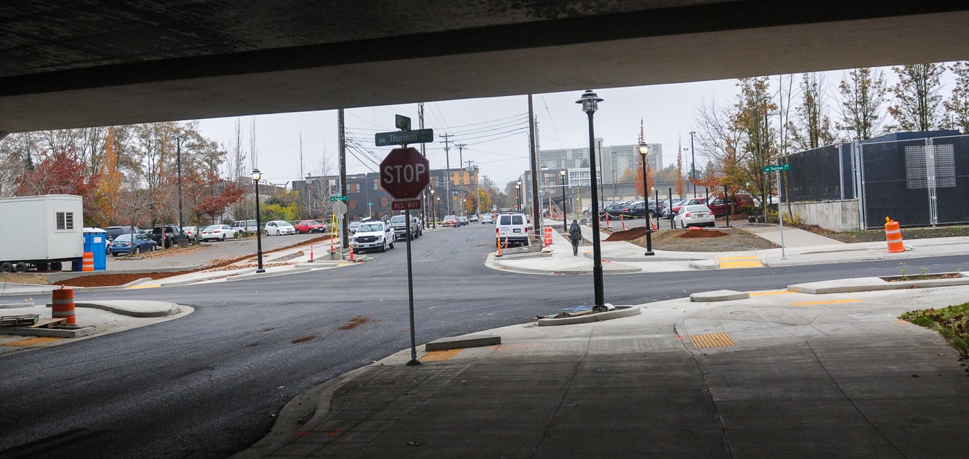
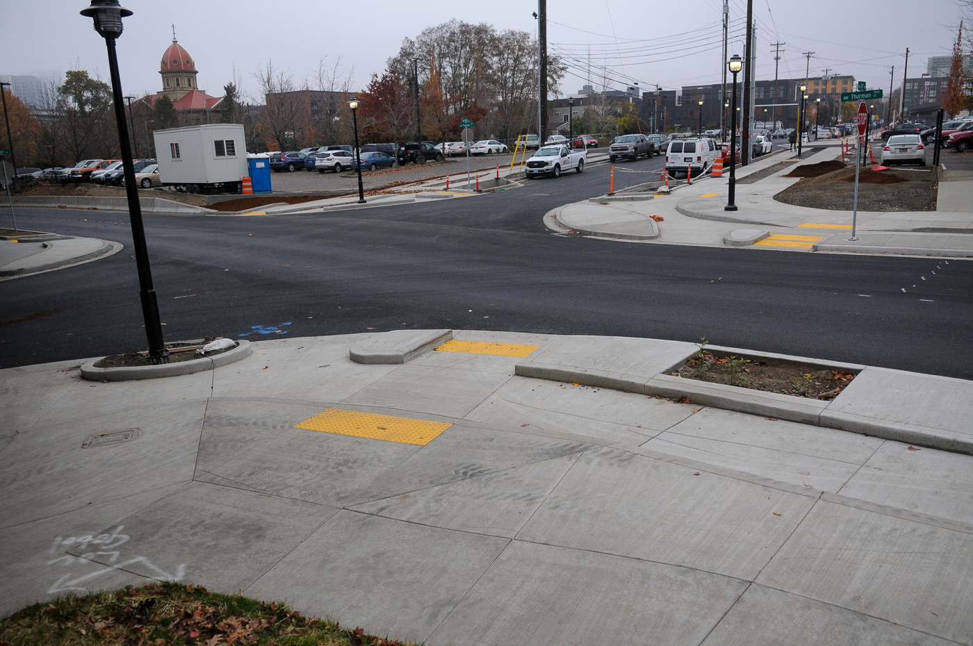
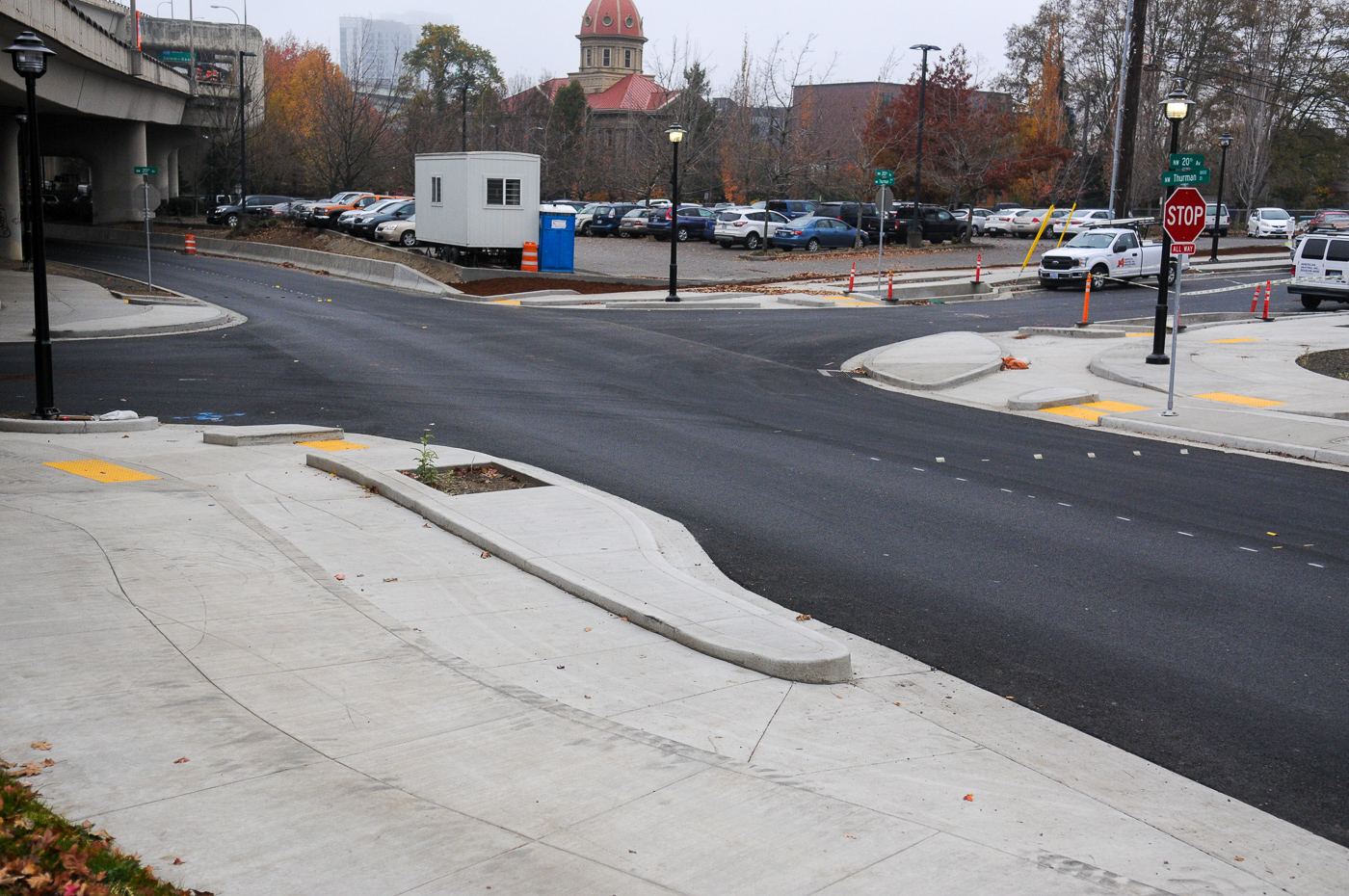
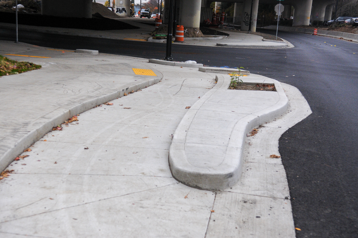
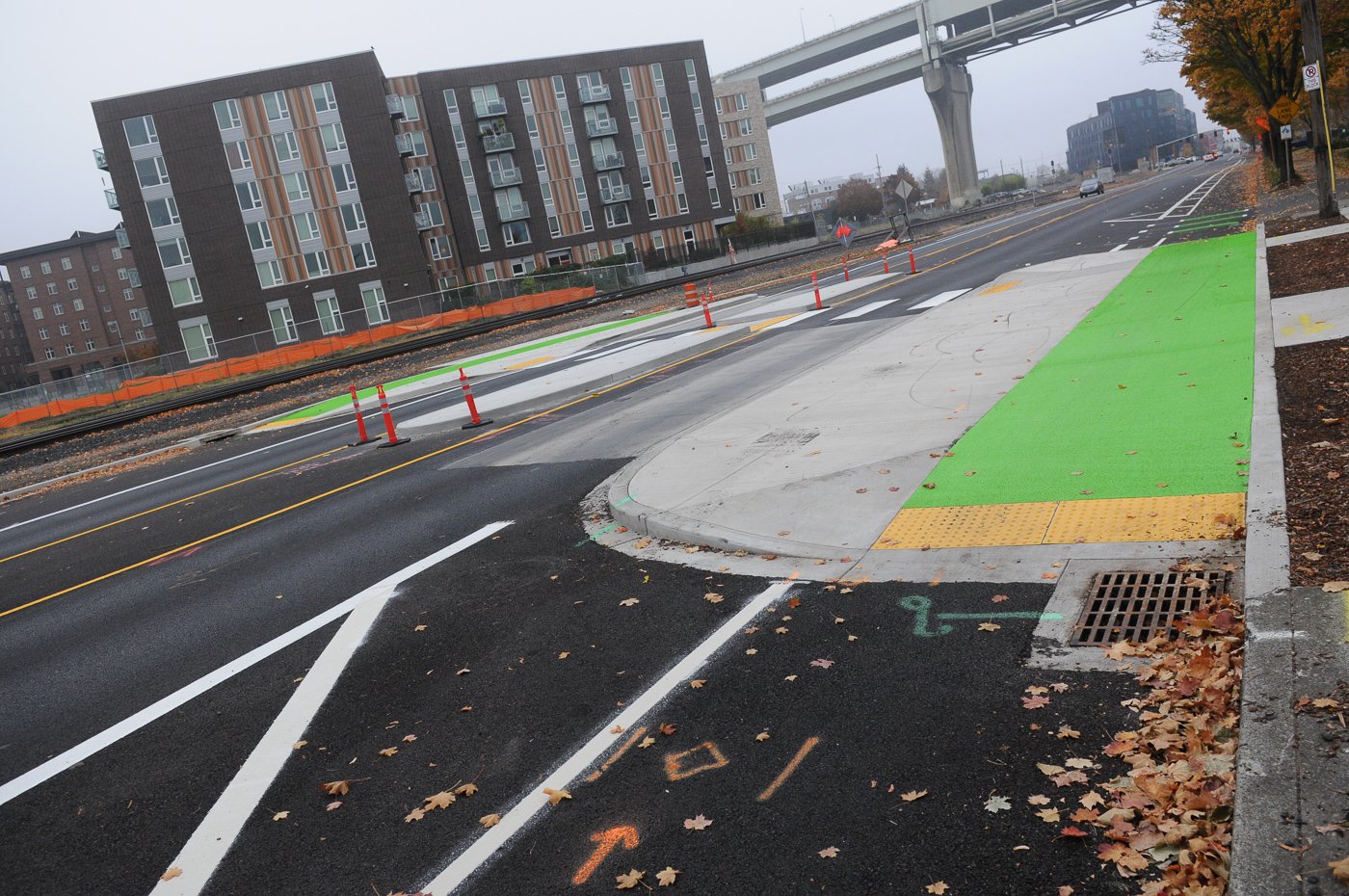
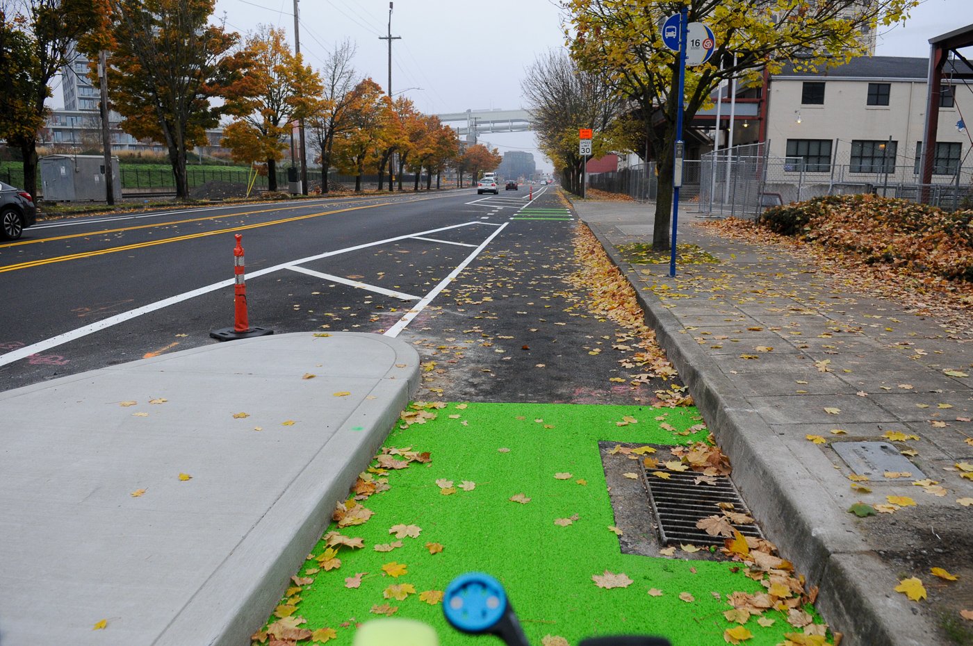
Portland’s first protected intersection is in progress at NW Thurman and 20th.

It’s part of a $7.5 Local Improvement District (LID) project paid for by private companies that are redeveloping the area. In order to connect Slabtown to the NW Industrial district, PBOT has extended NW 20th under the I-405 viaduct, and turned NW Thurman into one, two-way street 19th and 20th on the south side of I-405 (closing the northern section of Thurman which used to be a freeway on-ramp). In addition to the protected intersection, PBOT is building new bike paths throughout the blocks that will improve connectivity in this growing area of the city.

One concern I have is that the biking and walking paths are the same color and material. I hope there’s some way of defining the spaces so the bicycling area can be used efficiently and safely. (UPDATE: A reader below shares that the bikeways will be colored green. That’s good news.) I’m very eager to see how this works out once it’s all complete.
W Burnside 18th/19th

PBOT is slowly but surely making progress on their West Burnside Multimodal Safety Project. The goal is to make this tricky set of intersections safer and more appealing to all users. This project has been baking for nearly four years now and last time we checked in it was supposed to be done last fall. Most of the work is completed, but it’s not quite ready for prime time.
Advertisement
SW Main
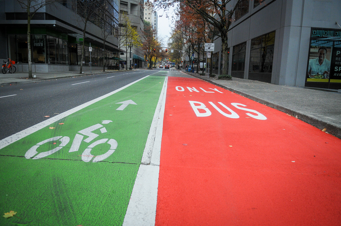


Our much-ballyhooed, first-ever red bus-only lane at SW Main between 1st and 2nd isn’t really that big of a deal. As part of an “experiment” with red transit lanes, PBOT has simply added red to a half-block area that was already “Bus Only”. During my observations this morning, it appeared to be working as intended. From a biking perspective, SW Main is still way more stressful than it should be. Drivers and bus operators both merge across the bike lane prior to 2nd Avenue and at 3rd bicycle users are dumped into a shared environment around the Elk Statue. Hopefully someday we can build a floating transit island, prohibit right turns at 2nd, and redistribute right-of-way west of 3rd from auto users to bicycle and bus operators.
Burnside Bridge
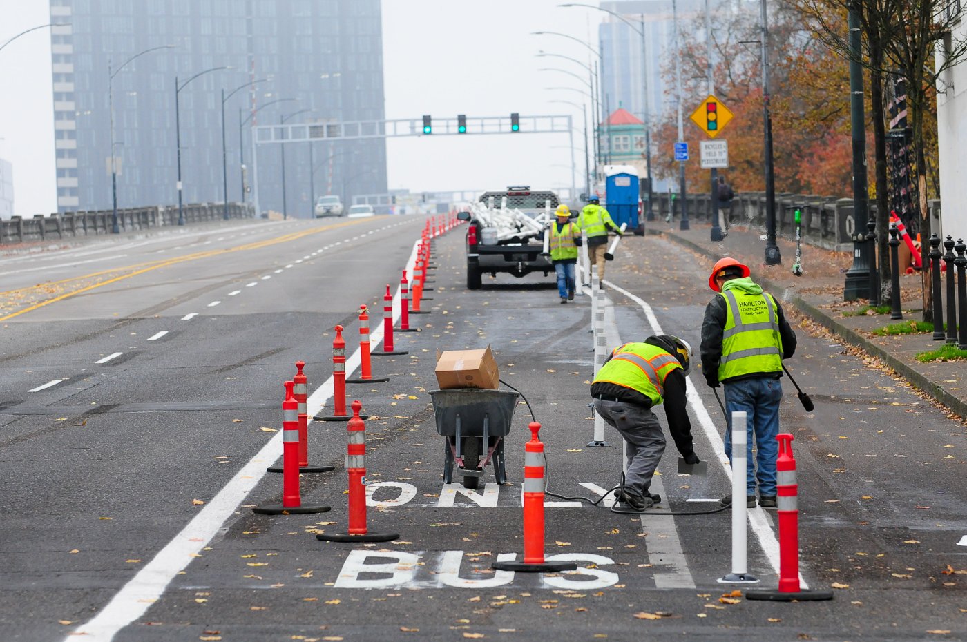
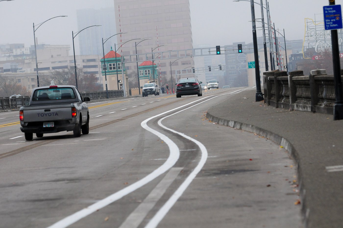
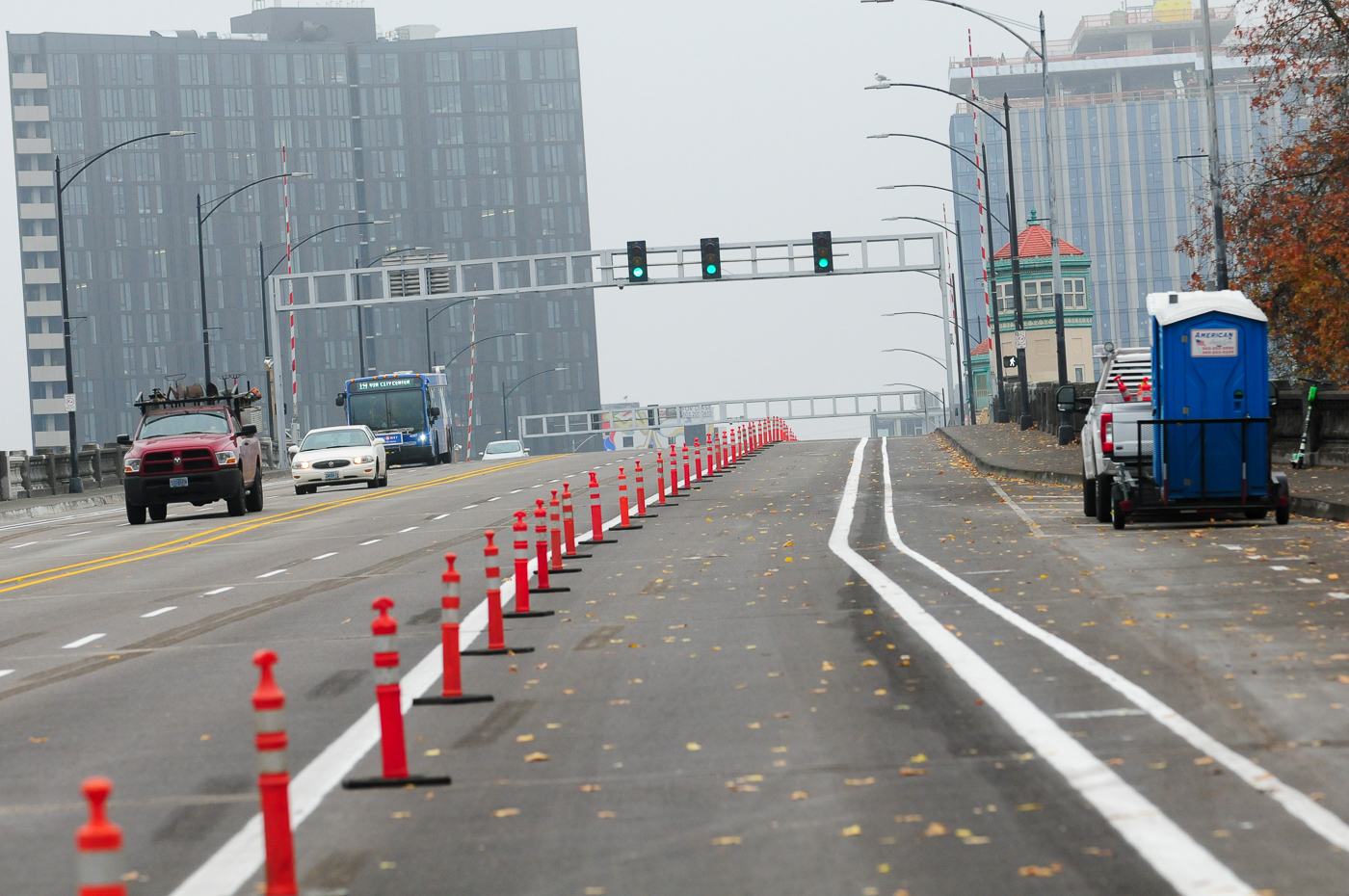
Multnomah County is finally done with a major bridge maintenance project. Before the bridge re-opened they partnered with PBOT to re-stripe the lanes in order to speed up bus service and improve conditions for bicycle users. Thanks to a nudge by advocacy groups, the County decided to install plastic wands in the newly buffered bike lanes.
The bus-only lane (which is only in the eastbound direction) wasn’t operational this morning, but I imagine it’ll be open soon. The County confirmed with me today that all the plastic wands will be installed by the end of this week. This means eastbound bicycling will feel much better once everything is installed and open. That’s because bicycle riders will only have to contend with professional bus operators in the adjacent lane and they’ll have a wider bike lane with plastic wands in the buffer.

Westbound won’t feel as comfortable because bicycle users will still have automobile users in the adjacent lane and will only be separated by plastic wands.
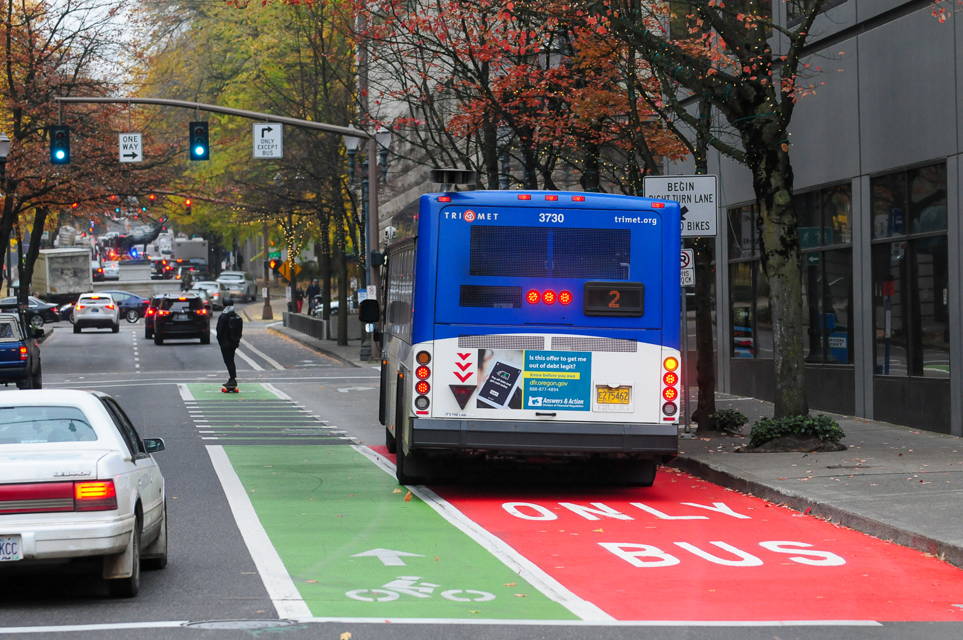
NE Grand


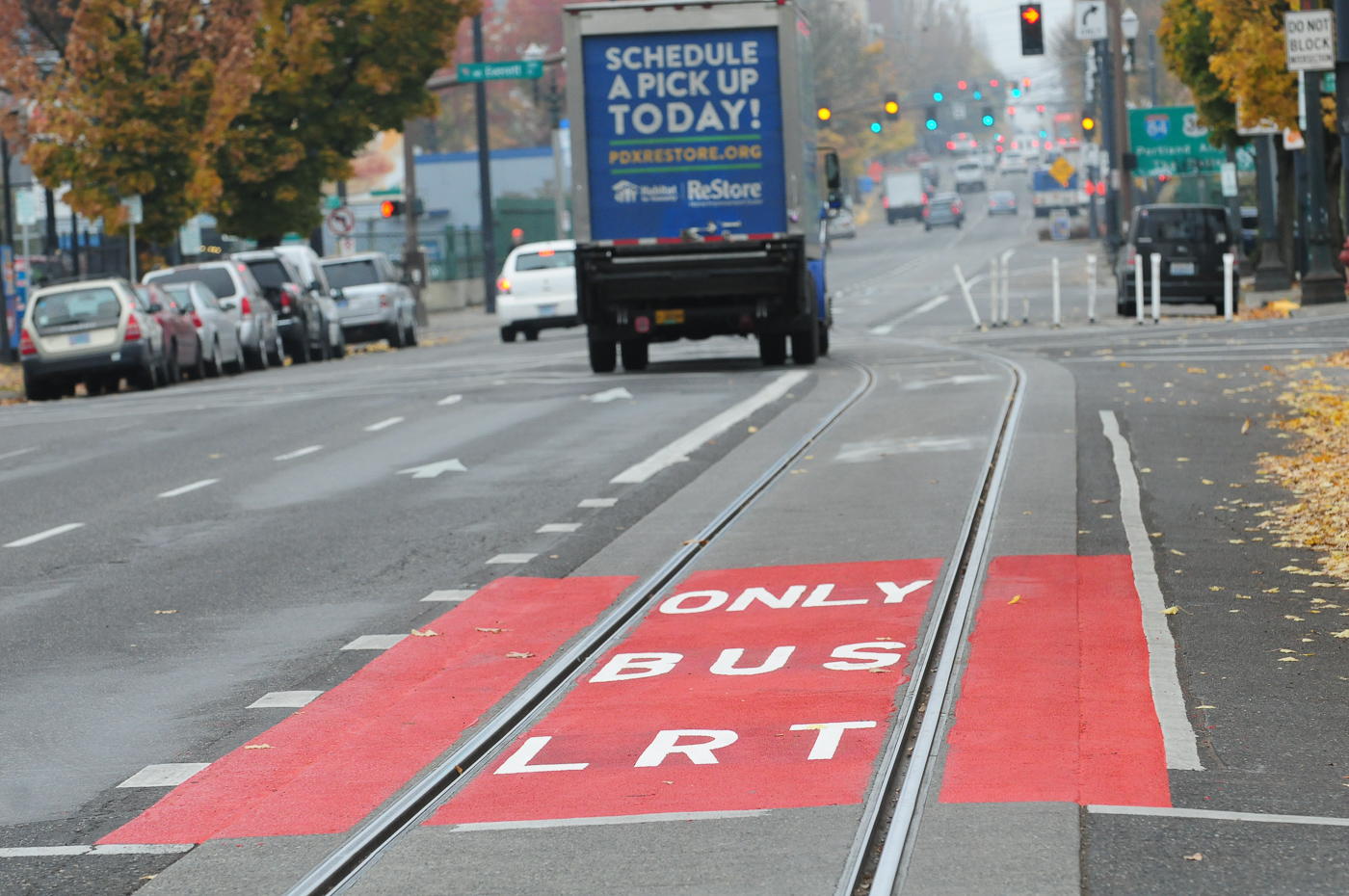
In addition to SW Main, PBOT is adding red paint to transit lanes on NE Grand and MLK. Similar to Main, they’ve laid down a very tiny chunk of red. On Grand it seems to be helping, although I did see people so eager to get on I-84 that they couldn’t resist driving over it this morning. I’ve asked PBOT if bicycle users are permitted to ride over the red lanes on Grand. While it doesn’t see a lot of bicycle traffic because of the streetcar tracks and very stressful environment, there’s no other place to ride. I’ll update this post when I hear back.
North Greeley
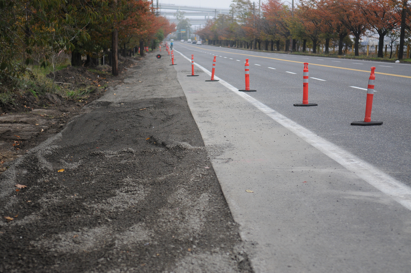
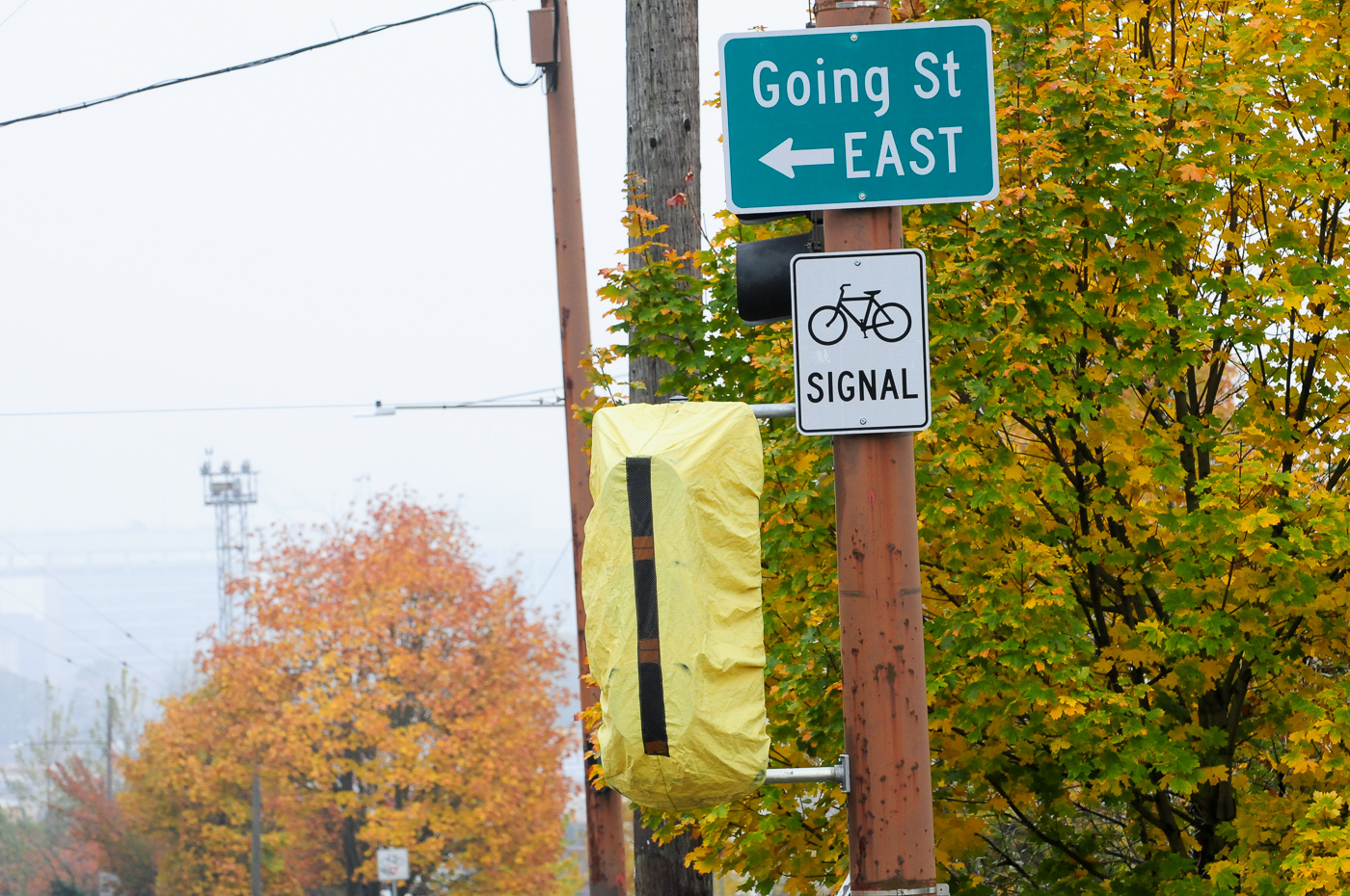
A few weeks ago PBOT started their project to build a two-way bike path on the east side of Greeley between Going and Interstate. So far the excavation of the shoulder has started and the bike-only signal heads at Going are up but not yet operational.

I found the work zone plan to be very inadequate and potentially dangerous. While PBOT announced a detour for bicycle users, it’s not well-signed. I got all the way to Greeley and didn’t realize the bike lane was closed. Construction forced me even closer to other road users who were traveling very fast in heavy vehicles capable of killing me. PBOT decided to close the bike lane, yet maintain all lanes for drivers. I hope everyone uses caution until the new bike paths are finished in February 2020.
For more on projects underway from the City of Portland, check their website. If you see changes on streets near you, please drop me a line. It’s impossible to track everything so I rely on you for help!
— Jonathan Maus: (503) 706-8804, @jonathan_maus on Twitter and jonathan@bikeportland.org
— Get our headlines delivered to your inbox.
— Support this independent community media outlet with a one-time contribution or monthly subscription.


Thanks for reading.
BikePortland has served this community with independent community journalism since 2005. We rely on subscriptions from readers like you to survive. Your financial support is vital in keeping this valuable resource alive and well.
Please subscribe today to strengthen and expand our work.
“One concern I have is that the biking and walking paths are the same color and material.”
The biking areas will be painted green, similar to SW Moody, except continuous. I would have preferred if they’d used asphalt, especially given that there was a lot of asphalt work done as part of the job, but for whatever reason they didn’t want to do that.
That’s good to hear Iain. Thanks.
That’s a lot of wonky concrete… welcome to the new restrictive biking program of PBOT.
Those yellow tactile surfaces are super-slippery and hazardous for cyclists when wet and should not be placed in the bicycle path. This alone would be enough for me to decide to take the lane in wet conditions.
I believe these are required to meet ADA standards. Since there is a ped crossing across the bikeway they are necessary.
Other cities use red textured pavement tiles with a far more grippy surface and truncated domes. Perhaps they are not as durable as yellow plastic sheets but people riding do go down on those — especially in the winter.
Bike lanes are also used by people riding mobility devices. In particular, wheel chair and scooter users also often rely on bike lanes. While people on bikes often have the forward momentum to easily mount those curbs, this is not always true for other forms of mobility (and especially on inclines).
The primary issue with the yellow bumpies in the bike paths is when they are placed at a location where the city’s path alignment and built environment has also forced the biker to execute a turn at the same time as crossing the yellow threshold. City should take careful measures to avoid making cyclists negotiate turns (and stops) over these yellow plastic bumpies.
The edges on all of those curbs are not mountable by cyclists and constitute another significant hazard for cyclists. They really need to refine their designs before installing new hardscape, these features are as much of a hazard as they are ‘protection’ for cyclists, if you hit one on a bike and go down you are going to hurt yourself. Not so much if you hit one with a four-wheeled vehicle.
More of the same half-measures and too-narrow bikeways primarily designed to keep bikes out of the way of cars, so cars can hurry up to the next red light. Until we prioritize non-car transportation at the network level and operationally in day-to-day efforts (including work zones), people are going to continue to respond predictably to this clear invitation to use cars for all trips.
I can’t think of a single one of these projects that is “primarily”, or indeed even partially, “designed to keep bikes out of the way of cars, so cars can hurry up to the next red light”. Indeed, many of these project take space from cars to give to bicycles. For example: vehicle lanes are being converted to bike lanes on NW 18th/19th/Alder and on NW Front, while N Rosa Parks removed surface parking to widen the bike lanes.
The Vehicular Cyclists are out in full force in the comments section. They will never like projects like this, so don’t waste your breath.
Are they? I didn’t see a single unambiguously “vehicular cycling” comment. The Vehicular Cyclist is a bit like Sasquatch — we all know they’re out there, and lots of reported sightings, but very little confirmed evidence that they exist.
Regarding the photo above of MLK (with the truck marked “Schedule a Pickup Today”), it would be very difficult to get into the turn lane without ether intruding on the red marking, or crossing the solid white line. No wonder you saw people driving over it!
Ooops… this should be a stand-alone comment. Not sure how it got nested here!
Greelely is a project to get bikes out of the way of cars/freight. they are widening lanes for motor vehicles and making the bike conditions much more circuitous and adding a few new conflict points for bikes.
The Greeley project replaces unprotected bike lanes, that are different adjacent to high speed traffic, with a wider two-way bike path that is separated from adjacent traffic by jersey barriers. The drawings are available view here (https://procure.portlandoregon.gov/bso/external/bidDetail.sdo?docId=00001196&external=true&parentUrl=bid) and show vehicle lane widths of 10′-6″ and 11′-0″. That provides a huge upgrade to safety and comfort levels for cyclists, while doing nothing to make it easier for cars to “hurry up to the next red light”. While we can debate the details of the project implementation, I find it sad that people who characterize physically separated infrastructure as being there for the benefit of vehicles.
Iain,
The outermost lanes are 12′ and 12′-13′ wide. The median speeds are already over 55mph in each direction. The MUP is 12′ wide INCLUDING the shy distance, effectively 11′. Also, they are calling this a MUP but not providing any space for pedestrians. This is being painted as a 2-way bike lane and there will not be adequate space for pedestrians. The length of the MUP is only 2/3’s of the route, the rest of the route is on an existing walkway that is less than 10′ wide and is used as a driveway. PBOT “plans” to add a bollard to exclude cars, but I am skeptical since the surrounding landscape is currently driven on- I expect people will simple drive around the bollard. this path joins the 5-foot wide Interstate bike lane at the bottom of the hill. To access the bike lane, the new “MUP” directs riders to make a series of 90-degree turns while a negotiating a single bike ramp (for 2-way bike travel) and merge into the bike lane. Basically, they did not design anything for the southern 1/3- and the proposal is rife with conflicts. Meanwhile, the driving lanes ARE getting wider, speeds are likely to stay the same or increase. A couple of people died on this stretch of Greeley in May and speed was a factor. I has been asking PBOT to address the high speeds before and since the fatalities. PBOT directly told me that this project was being for with “freight money” and that it was not addressing safety or looking at fixing the bike infrastructure. PBOT had a little bit of free space for part of the route, and they are moving bikes into that space despite the fact that rest of the route is not adequate.
” I find it sad that people who characterize physically separated infrastructure as being there for the benefit of vehicles.” You do not understand my perspective at all. The project eschews safety to provide speed and convenience for freight. People walking, biking and driving all suffer from PBOT not addressing safety and not creating safe connections or adequate space. This project addresses the conflict of bikes crossing the slip lane, but it not create a complete or safe connections for people biking, the space for biking is significantly smaller and it reduces the space for pedestrians.
I’m not really interested in getting into a detailed debate about the minutiae of the Greeley project, except to say that I posted a link to the drawings above and that I think you are describing it various ways that don’t match the drawings.
OP said that these are projects “primarily designed to keep bikes out of the way of cars, so cars can hurry up to the next red light.” I don’t agree with that statement, either in general, or specifically as it relates to Greeley.
I sat down with PBOT and reviewed the drawings, I know what is in them.
“The Greeley project replaces unprotected bike lanes, that are different adjacent to high speed traffic, with a wider two-way bike path that is separated from adjacent traffic by jersey barriers. The drawings are available view here (https://procure.portlandoregon.gov/bso/external/bidDetail.sdo?docId=00001196&external=true&parentUrl=bid) and show vehicle lane widths of 10′-6″ and 11′-0″. “
The exterior driving lanes are 12’ and 12’-13’ wide. The 85th percentile speeds on N Greeley are 56 mph southbound and 59 mph northbound. Instead of narrowing the lanes to reduce speeds, they are widening the lanes. The bike lanes are gaining protection, but they are getting reduced in width. At their widest, the 2-lane bike lane will be 12’ wide, but that includes the shy distance from the jersey barrier and gravel shoulder. Even though this is shown as being painted as a 2-way bike path with 6’ (5’ effective) wide lanes, it is being called a MUP, so where will the pedestrians go?
“That provides a huge upgrade to safety and comfort levels for cyclists, while doing nothing to make it easier for cars to “hurry up to the next red light”. “
The portion of “MUP” this project is constructing is only 2/3’s the distance of the route. The rest is on an existing walkway that is less than 10’wide and used as a driveway. I rode it last month and counted 7 personal vehicles parked at Hazelnut Grove. The walkway is also used to drop off materials, access by emergency vehicles, and to service the portapotties and dumpster. PBOT plans to install a bollard, but vehicles currently drive all over the adjacent landscape so I am dubious that will help. This project reduces the space for bikes and reduces the space for pedestrians. It does not address the dangerous speeds even though there were 2 speed-related injuries on this stretch of road last May. PBOT directly told me that this was funded with “freight dollars” so it was not going to address safety concerns or complete the bike route.
“While we can debate the details of the project implementation, I find it sad that people who characterize physically separated infrastructure as being there for the benefit of vehicles.”
You misunderstand me completely. PBOT has explicitly said that this project is being done for the express benefit of the freight haulers. It is not addressing safety needs of people walking, biking or driving. There literally are no details for 1/3 of the project route because PBOT is not doing a single thing there. 2-way bikes and peds are being crammed on to a less than 10’ wide path with light poles, poor site lines and vehicle conflicts. The southern terminus requires bikes to make a series of 90-dgree turns and negotiate a single ramp, for 2-way bikes, and merge into a 5’ wide UNPROTECTED bike lane at the bottom of a hill adjacent to fast-moving cars and trucks.
All of North Portland is funneled into a couple of routes to connect with the rest of the city. The unprotected lanes were not good, and the dangerous merge across the slip lane was dangerous, but this is not an improvement- this trades one set of conflicts for another set without holistically designing a street improvement that would work better for all users.
Greeley… we could just take over the Railroad right of way and build a wide paved path with singletrack on either side and fun dirt jumps up on the side of the hill.
Jonathan, did you happen to check out the southern 1/3 of the Greeley “MUP”? It is a concrete walkway that measures less than 10′ wide and has a couple of light poles in it. It is also used as a driveway by residents of Hazelnut Grove. I am wondering if they are addressing any of insufficiencies on that stretch? Also, PBOT is calling it a MUP, but at its widest it only 12′ wide including shy distance from the concrete barrier and it is being striped like a 2-way bike path. Where will pedestrians be expected to go and how will all users of the MUP know how to use it? Since most of this path has considerable grade, I would expect pretty big speed differentials and a lot of opportunities for conflict
Those are great questions maxD. I know the southern section well as I live in north Portland myself and have ridden the existing path and Greeley many times over the years. I hear your concerns about the part near Hazelnut Grove and I agree that light pole is very poorly placed. There are no plans to address that existing path AFAIK. Seems like it will be a wait and see approach.
Any idea how the “MUP” will work? If they stripe it for bikes, where would pedestrians be expected to be?
I suspect it will be just like the esplanade, waterfront park and the springwater, all of which have the issues you’ve pointed out. Faster moving folks alert the slower moving folks and pass when safe.
One day we’ll build infrastructure the way Vancouver, BC has- a path for wheels and a path for not.
Andrew, I get how those MUP’s work, but they are explicitly for people. The renderings of this “MUP” shows it painted with a centerline. Also, most of the route has pretty significant grade so people on bikes will be potentially traveling very fast, at least ion one direction. All of the MUP’s you mention have very well-known and often-discussed conflicts between pedestrians and people on bikes. Have you ever tried to take a walk with a stroller and a dog on the Springwater or the Esplanade? It is enough to make you hate people on bikes. Parks has gotten this memo as evidenced by the latest section of the Willamette Greenway that provides a clearly defined space for people on bikes that is separate from people on bikes. This “MUP” is undersized and has conflicts built right into the design. I am not a fan, but my question is earnest: Is this a MUP and intended to be shared by pedestrians, or is it a 2-way cycletrack, which is what it looks like? If it is a MUP, how will pedestrians and bikes know what is expected? The painted centerline implies/mandates directionality, at least for bikes, so what do pedestrians do?
None of those paths are constricted by overgrown vegetation, nor do they have light poles in the middle(!) of the paved path. All of them are wider than that path. None of them are places where transients are allowed to drive and store vehicles for long periods of time. In the area where the Greeley bike path passes hazlenut grove, it is comparable or worse than the worst of the worst places on the I205 bike path or the Springwater Corridor. It is acceptable, though scary to use it as a one way bike path with foot traffic, and all too frequent vehicle(!) traffic in its current configuration. With two way bike traffic, more frequent pedestrian traffic, and continued(?) vehicle traffic, it will be an outrageously bad bike facility.
I can’t believe you are defending it and trying to act like it in any way compares favorably to bike infrastructure that was built decades ago. We know how to build good bike infrastructure now, but we continue to have garbage foisted upon us.
There is zero new infrastructure between Williams and Willamette on Rosa Parks. Are there plans to put in concrete barriers along this section of the new bike lane on Rosa Parks? I was under the impression that there would be some form of physical protection along the entire bike lane.
This was not supposed to be a reply to this comment. I don’t internet well.
As a frequent user of 18/19th and Burnside over the last few years, I don’t think it will improve conditions for folks who don’t mind being in a full travel lane, but hope the project is an improvement for the majority of users.
They just laid down some lines back to Hoyt that seems to create a super tight mixing zone right before Glisan (and the lines seem a bit “off kilter” and not exactly parallel to the curb line, but maybe once the whole project its in final form, it will function well.
Except in places you really can’t, like the MUP alongside the Orange line just west of SE Division Pl. Slipped on that yellow surface again this morning, and I was even anticipating it! I really don’t understand the usage of that material in a situation where you know and plan for many cyclists to be riding there.
I’m thinking they have to have them anywhere a ramp is coming down from a pedestrian zone onto a roadway, for blind walkers. This is a tough one, because we really need to help the blind where we can, but they are a hazard for cyclists.
From my conversations with engineers they don’t have to be that slippery it’s just what’s currently in use and no one is planning on changing that any time soon. Another example of our complaint driven city they won’t fix the problem until they get sued or enough home owners call to complain.
And that’s an excuse for using them? Exactly how? Engineers of all types are often incredibly short-sighted, it’s kind of sad, but that’s still not an explanation that justifies these types of installations.
Not only is the Vancouver/Cook area sketchy to ride through, the way cars and bikes have to weave past each other is also a big source of traffic congestion. I routinely ride past cars backed up all the way from Skidmore to Fremont in the morning.
If they moved the bike lane to the left side of the street like it is on Williams, that would solve both a safety and congestion problem.
You have an additional problem there- the people driving into the new seasons parking lot. It’s not uncommon for me to have several near collisions there during a single pass on Williams, which has the bike lane on the parking lot side. I don’t think moving the lane on Van to the left would be as clean a solution as we think.
I’d bet $$ that the traffic split at Fremont/Vancouver at 7:30 am is 1% new seasons, 99% freeway/south on Vancouver.
Both Williams and Vancouver should have cement jersey barrier protected bike lanes, and left side bike lanes. Remove parking and put in bus only lane segments as much as possible.
Went by the Willamette bollards last night they appeared to be working well. In my experience most people take that corner pretty slowly but the few who didn’t now have to. Now the sketchiest part of my trek to Saint Johns is when the bike lane runs out and drivers really want to get to that stop sign at Richmond with the traffic to the right doesn’t stop sign. Anyone know why that intersection exists like that? It’s only one I can think of and I don’t really get the purpose.
Whatever PBOT calls the cycle track along the east side of N. Greeley it is not and will never be, in my view, part of the continuous MUP…the North Portland Willamette Greenway Trail…from the confluence of our two great Rivers to the Eastbank Esplanade. npGreenway’s preference (Friends of the N. Portland WGT) and the City’s adopted alignment follows the existing Ash Grove Cement Road from N. Port Center Way (at the Swan Island Pump Station) to N. River Street under the Fremont Bridge. That 20′ concrete and asphalt facility is in place, was used for emergency access to Swan Island after the UPRR derailment, and merely needs to be transferred to public ownership and/or opened to public use.
Lenny. I would love to see a map of the N Portland MUP from the two rivers headed south to the downtown bike path at the steel bridge… I support that MUP. Thanks.
I’m concerned the newly-built NW 20th Ave extension isn’t entirely or even primarily “In order to connect Slabtown to the NW Industrial district.” Plans are for >6,500 vehicles per day on the newly-built stretch of Thurman (at 20th) alone, primarily serving as a new freeway connection looping around from the north. For reference, the entire NW district currently originates a total of 12,000 motor vehicle trips per day on all of the streets in and out of NW. It’s unclear to me how all the new people in cars are going to coexist with each other and with people trying to get around NW on foot, bike or bus. Is the visually striking protected intersection a greenwashing of a developer-funded LID project that will pump thousands of new in-neighborhood car users and cut thru drivers onto NW surface streets?
I’m sorry, but the NW 20th/Thurman project looks like hell on earth.
Who is it at PBOT who thinks that narrow, curving bike lanes enclosed by three-inch raised curbs are a good idea? Do bicycles need to be confined by curbs to keep cyclists from crashing into cars and peds and property? Or are the curbs there to keep cars from crashing into bicycles?
I can’t remember if Jonathan came out to SW Vermont to review the new (within the past couple of years) shared bike/ped area west of 45th, but the designers of this new facility were so committed to the idea of having a raised area for cyclists and peds that they raised and lowered the path every couple of feet to accommodate the many driveways that cross the path. It’s like riding on a washboard!
The protected lane on Rosa Parks is the way to go: leave the bike/ped lane level with the roadway and then protect it with three-inch barriers that will stop a car (okay – slow a car), thereby protecting the cyclists and peds, while allowing cyclists to stay well away from the barriers.
If DOTs had cycle throughput standards on par with those for motor vehicles, these narrow, constricted paths that force cyclists to stop all the time would be prohibited.
You…can…take…the…lane…speed…racer.
Great update!
re BURNSIDE BRIDGE: it’s great not to have to share the sidewalk anymore! the eastbound wands are not great because it makes passing slow cyclists. also not great is the right turn arrow left in the westbound bike lane at 2nd ave..
wands are not great because it makes passing slow cyclists difficult in the tight space.. *smacks forehead* proof read before send 😉
Exactly! It’s even slippery when you do walk on them. I get that there needs to be some sort of tactile interface at these intersections. Seems like a good and reasonable thing to do. It seems ridiculous that this tactile interface that PBOT has chosen is SLIPPERY WHEN WET. WTF.
N Vancouver (2nd or 3rd highest utilization bikeway?): south of Fremont through Cook is a nightmare. An effective solution would be to move bikeway to the curb from Fremont through Cook—yes, there’s a bus stop but I’d rather trust TriMet drivers than distracted in-a-hurry freeway destination drivers.
re BURNSIDE BRIDGE (update): westbound wands magically appeared overnight (and i think they are awful). wands+width of bike lane make passing a slow cyclist or bike-truck nearly impossible (unless you can eye an opening in traffic and weave fast). how are they going to sweep the lanes? these should be removed.
westbound bike lane @ 2nd: cars are using the bike lane as a turn lane. does PBOT have a plan to prevent this?
so unwilling to sacrifice a few seconds of your transit of wee bridge because slower moving traffic is in front of you…
what does that attitude remind me of?
pretty much (though more than just seconds, it can be minutes).. and it forces me to stay at a quite inefficient speed for my gear.
snark aside, design (especially of new facilities) should accommodate the wide variability of human powered transport (and thus allow the ability to safely leave the designed infrastructure to overtake).
The bridge is 0.33 miles long. Someone going 12 miles per hour takes 1.66 minutes to cross (1.11 minutes for someone going 18 mph).
But you do raise an important question: who should we prioritize infrastructure for?
People who want to hit the hammer in bike lanes or people who are tentative cyclists and/or use buses?
I hope that people using buses will not be in the bike lane!
Are you upset by the dedicated bus lane being striped?
Why would I be? I would, however, be upset if a bus were driving in the bike lane.
But think of the e-bike users…a lot of these people used to be the slow cyclists you once passed, now they are passing you!
I’m just glad the wands aren’t curb mounted. Agreed that it could be challenging to pass slower moving people on bikes, but not impossible if done carefully.
I did notice that in less than a week, one of the westbound wands has already been knocked over. This was on Saturday, so there could be more by now.
Your loved one here. Nope. That curve at Rosa Parks remains deadly until they put in a cement jersey barrier. Watch this video… One second after a cyclist makes the turn, a truck crushes the plastic wand. I’m on foot crossing in a crosswalk and I get verbally abused for walking too slowly.
https://youtu.be/bjJoEs-HEHA
Wow! No reason at all that a truck like that should be allowed on that road. Totally unacceptable.
I have to ask… why did you yell at the driver who stopped for you?
I’ve seen the same thing happen over and over since the new curb and wands were installed! Trucks of all sizes and plenty of cars roll right over the curb, and sometimes that last wand. While I appreciate the efforts of those who work to implement these safety measures, this one seems built to be defeated by vehicles.