
(Photos: J. Maus/BikePortland)
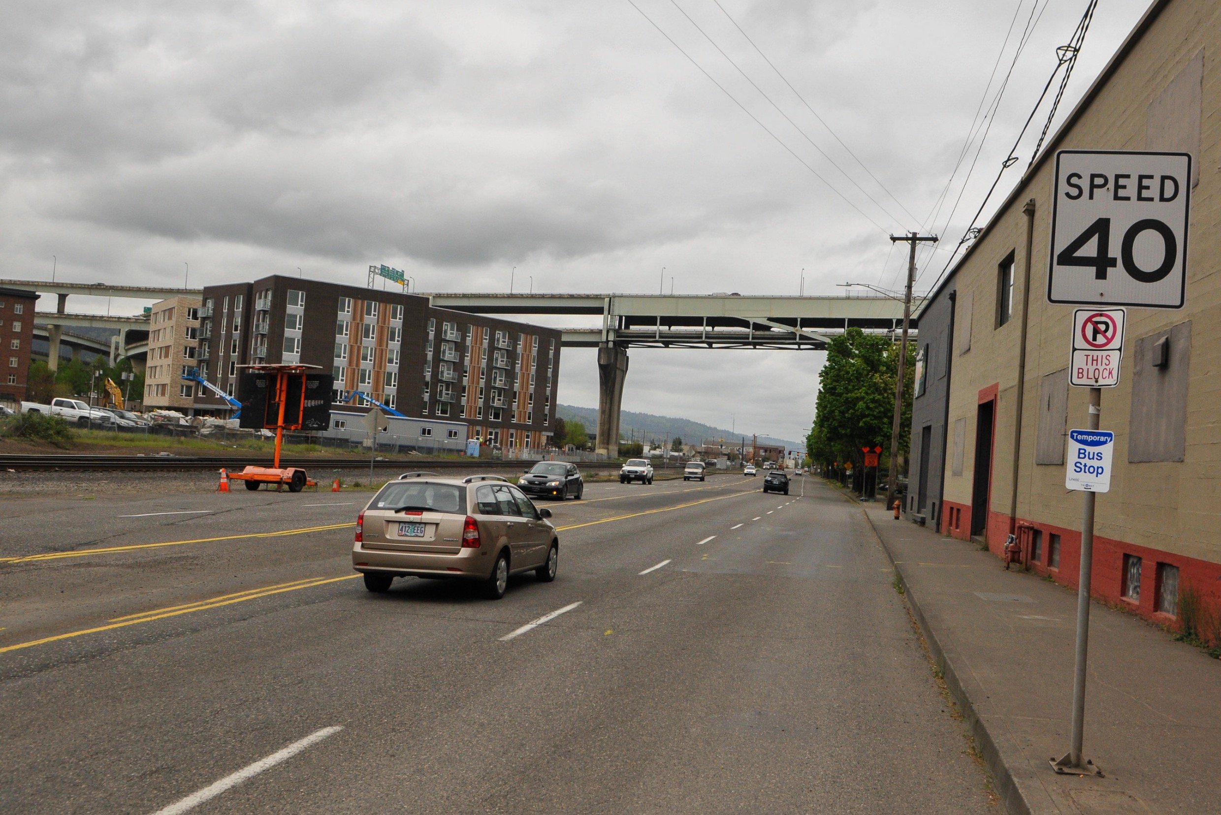
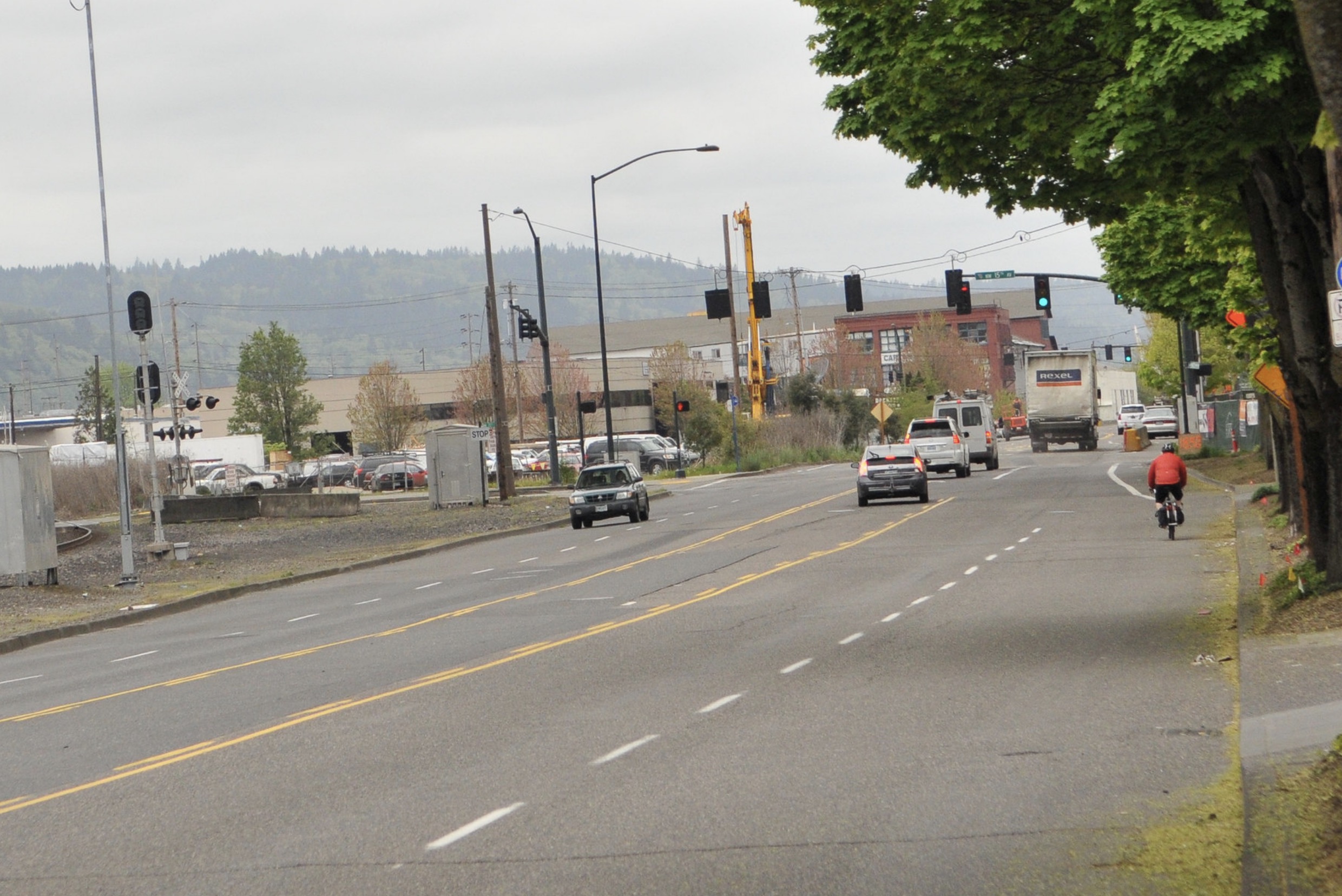
A major gap in our central city cycling network is about to be filled. For years people riding bicycles have had to share lanes on NW Front/Naito Parkway between NW 15th and 9th where there were five wide lanes, 40 mph speed limits, and no dedicated cycling space. Now the final piece of a project that began in 2017 is close to completion and it will come with fewer driving lanes and new buffered bike lanes that will run behind updated bus stops.
As residential and commercial development on NW Front has skyrocketed in recent years, so too has the need for a safe bicycling connection on Front/Naito between the Steel Bridge, the Pearl District and the Northwest Industrial Area. PBOT added bike lanes north of 15th Avenue back in 2017 and now they’re about to fill in the gap to the south.
Here’s what it used to look like:

And here’s a look at the new bus stops (new lane striping isn’t done yet):


The changes come as part of the Portland Bureau of Transportation’s NW Front Avenue – Naito Parkway Local Improvement District (LID) created in March 2017 with Park Office LLC, owners of a major nearby development. They contributed $1.1 million toward the project (and received System Development Charge credits) to repave Front/Naito and improve cycling conditions.
Advertisement
During a ride through the area over the weekend I noticed the paving is done and preliminary striping marks are down. In addition to the new bike lanes, what really caught my eye are the new transit islands located just south of the Fremont Bridge near several large office buildings. PBOT has designed the bike lane to run behind the stops in order to avoid the “leapfrog” phenomenon where bus operators service stops at the curb and encroach into the bike lane. These new transit islands also allow bus operators to stop in the sole driving lane, so they act as traffic calming as well.
These new transit upgrades will be key if Portland is ever successful in attracting a Major League Baseball baseball team whose new stadium would be located on the riverfront along Front Avenue.
In addition to the new lane configuration, PBOT also plans to upgrade curb ramps and partially rebuild traffic signals at 9th, 15th and 17th avenues. The project is likely to be fully completed before the start of winter. I’ve asked PBOT whether or not the bike lanes will be protected and when we can expect the project to be finished. I’ll update this post when I hear back. Also stay tuned for full photo recap once everything is done.
UPDATE, 4:49 pm: Here’s what PBOT says about the bike lane design and schedule:
Bike lanes on either side of NW Front Ave will be 7’ wide with a 3’ buffer from NW 9th to NW 17th. From NW 17th to a little north of NW 18th, the bike lanes will be 6’ wide with a 3’ buffer. The buffers will include surface mounted tubular markers spaced approx. 20’ apart for the majority of the project and will be parking protected in a few spots.
With the clear weather window that we have this weekend, contractors will be doing the long line striping (centerlines, bike lanes and buffers) between Friday and Tuesday. We’ll have more information on the rest of the striping schedule after a meeting with the contractor later this week.
— Jonathan Maus: (503) 706-8804, @jonathan_maus on Twitter and jonathan@bikeportland.org
— Get our headlines delivered to your inbox.
— Support this independent community media outlet with a one-time contribution or monthly subscription.


Thanks for reading.
BikePortland has served this community with independent community journalism since 2005. We rely on subscriptions from readers like you to survive. Your financial support is vital in keeping this valuable resource alive and well.
Please subscribe today to strengthen and expand our work.
Fewer lanes across the metro, please!
Controversial take: it’s not a bus island. It’s actually just a large sidewalk that you have to bike on.
No tactile delineation of any kind so far that would alert a vision impaired user they are standing in a travel lane. It’s also confusing for scooters, who are reminded constantly they are not allowed to ride on sidewalks. This is my biggest issue with sidewalk level bike lanes. With no material difference it’s just a sidewalk, and invites conflict between users. Make it asphalt, or grade separated a half inch. Is there plan to have the ADA rumble strips on both sides of every bus island in the city? Good gracious. This was not designed for world class biking.
I would prefer it to be asphalt (especially given that they were doing asphalt work as part of the project!) but the plans do show green paint being applied where the bike lane goes between the sidewalk and the bus island.
I’m not sure why the tactile strips are in the wrong place. The should be where the crosswalk goes over the bike, like this: https://goo.gl/maps/cYhs2gFRCA4njgK2A. Thankfully that should be a relatively easy fix.
*They should be where the crosswalk goes over the bike lane…
At least they’re not erecting signs asking people to walk their bikes across the island.
But seriously, either the City doesn’t view bikes as traffic that could be hazardous to someone who can’t see them, or (more likely, based on how often they’re done wrong) the City doesn’t understand the purpose of tactile warnings.
Here’s one of my favorites–just recently completed on the Willamette Greenway Trail–a 15′ wide curb cut with a ceremonial 5′ of tactile warning strip. Will people who can’t see be drawn by the yellow color to walk only in the middle third of the curb cut?:
https://www.google.com/maps/@45.473065,-122.6699636,3a,75y,144.89h,61.83t/data=!3m6!1e1!3m4!1sUz90k29QZ-zw1E90DgVwtQ!2e0!7i13312!8i6656
I’ve been riding this area for years. The new asphalt is welcome, but the raised bus stop ramp isn’t all that great. Not sure why they can’t make those ramps at a slightly less steep slope so they’re friendlier to a bike at 20mph? Oh, I need to slow down for no one on the stop? I prefer to take the lane there, but often times a line of cars is coming, so, fine, I’ll do the bus stop ramp thing. So far there’s been a lot of gravel & road debris building up in the corner “pockets” where the island juts out and the curb ramps up/down. I’m waiting to see what they do with the lane striping approaching NW 9th. A lot of times cars are backed up at the light, and drivers like to cut around on the right side/bike lane to make the turn onto 9th. I’m hoping that’s turned into a protected bike lane in that area approaching the intersection. Of course a great solution would’ve been a separate, raised bike lane on the railroad right of way, but…
And those “LEGO blocks” are nice and slippery this time of year. I imagine most riders will move into the car lane unless traffic is really backed up.
Per PBOT engineer I talked to last week there will be protection so SB drivers approaching 9th won’t be able to use the bike lane as a right turn lane. Didn’t get details. I’m optimistic.
I dug through a couple pdfs on a procurement site. Looks like there are plans to add 294 “surface mounted tubular markers” and 84 linear feet of 2-rail metal handrails. The markers will run the whole length of the lanes on both sides from 17th to 9th, with breaks for business access. 2300 square feet of green bike lane marking, mainly in the bike lanes before intersections., and in the bike lane on the islands. I’m guessing the handrails will be placed similar to those in the Halsey/Gateway bus islands.
https://procure.portlandoregon.gov/bso/external/bidDetail.sdo?bidId=00000944&parentUrl=activeBids
Wow. Another new facility I will have to try out!
UPDATE, 4:49 pm: Here’s what PBOT says about the bike lane design and schedule:
I am so excited that I survived the super dangerous interim where the construction forced you right into the un-lit path of 50mph cars. There had to have been a better way to set up the road during construction
I’ve been following this project closely since April when I started working along the corridor. The cones have been in the way many times over the past year, but project managers have been responsive in the past month or so and have made a few minor tweaks. I think a bike lane and bike box on 9th from at least Overton to Naito would make a big difference and reduce sidewalk riding in a good way.
Aside from the tactile domes being installed incorrectly, there doesnt appear to be any form of overhead lighting at this bus stop and crosswalk. Is that correct?
So Catie points out the problem of conflict with transit users waiting on the island, whilst EP complains about having to slow down for no one because of the ramps. It seems to me slowing down through the potential conflict spot was the point, and an acceptable although imperfect solution for addressing both issues (baffling tactile strip placement notwithstanding). If it gets to the point that pedestrians are frequently crowding the bike lane then maybe it’ll warrant a different fix, but that’d sure be a welcome problem to have in the bigger scheme of things.
This island is a weird one, as there’s no sidewalk or public property next to it on the west side, just gravel and debris, and I think you’re trespassing if you walk along/on the railroad property there. So there’s no real reason to have the island interrupt the road surface on the west side. People will cross Naito to the island to wait for a South-bound bus, or get off a bus there and then cross Naito to the East-side sidewalk. It’d be nice if you could zip behind the stop on asphalt at the road grade level, just like how the Halsey-Weidler bus islands are built. This level, straight, section along the tracks is one of the few spots in town where you can get your bike up to speed and just ride without fear of anyone turning into you or cutting you off. Until PBOT throws a bus island in your way.
this is a reasonable start, but why not take this opportunity to close the gap between 9th and Kitteridge? The bike lanes should extend MUCH farther north. PBOT is always playing catch up and waiting until there is a need and dangerous conflicts (often for decades) before filling gaps in the network.
I think in situations like this, it is better to just wait a few more weeks until the striping is complete etc before publishing articles reporting on it. As it stands, the unfinished project just seems to be leading to a lot of confusion in the comments.
I personally am stoked for this project. There has been so much new business and residential development along this stretch of Naito. It is good to finally see the appropriate infrastructre catching up.
I disagree strongly. The article clearly conveys that the project isn’t done, and that more striping, wands, or whatever may have yet to be installed. People commenting also seem to have no problem understanding that.
If anyone here is expressing concerns, and it turns out the concerns will be resolved as the project progresses, great. But a lot of the concerns aren’t going to be resolved–i.e. people who brought up the drawbacks of projecting the sidewalk out into the street aren’t going to have that concern solved by some paint added later.
More importantly, some concerns being raised as a result of this discussion may be things that the project overlooked, and raising them now may make it possible to fix them, whereas waiting until it’s all done may make it much more difficult to fix. As an example, the tactile warnings at the curb ramps at each end of the bike lane don’t make sense as the project stands now, and won’t make sense if the project correctly adds tactile warnings along both sides of the bike lane as it crosses the raised platform. But waiting to say something until after the project is inspected, signed off on, and opened will just make it less likely that things will be fixed.
I say this all after years of trying to get drawings and info about projects BEFORE they’re built, and being told, “Wait until it’s done rather than speculating about problems”, then after it’s done and reporting problems, being told, “That’s a great point, but unfortunately it’s too late to change anything”.
Some have commented about ramping up to sidewalk level at the bus stop. The design makes the ‘island’ essentially a curb extension the bike lane mounts and this could be confused with a true curb extension where the lane passes to the left, rather than the intended ‘island’ where it cuts through to the right. This confusion is especially true when approaching from downtown on Naito and passing the new true islands at 9th where the bike lane remains at street level and is paved with asphalt. Minor quibbles, but having a consistent and predictable design is less confusing for everyone.