Last week a reader shared photos of some intriguing bike lanes. They raised my eyebrows for several reasons.
First of all, I hadn’t heard anything about the project. As someone whose job it is to know this type of thing, that felt weird.
And second, they were in a location where I have never heard of much cycling demand ever. Not that I believe we must demonstrate the presence of bike riders before building infrastructure for them (just like we don’t have to show how many people swim across a river before we build a bridge), but this location was very curious.
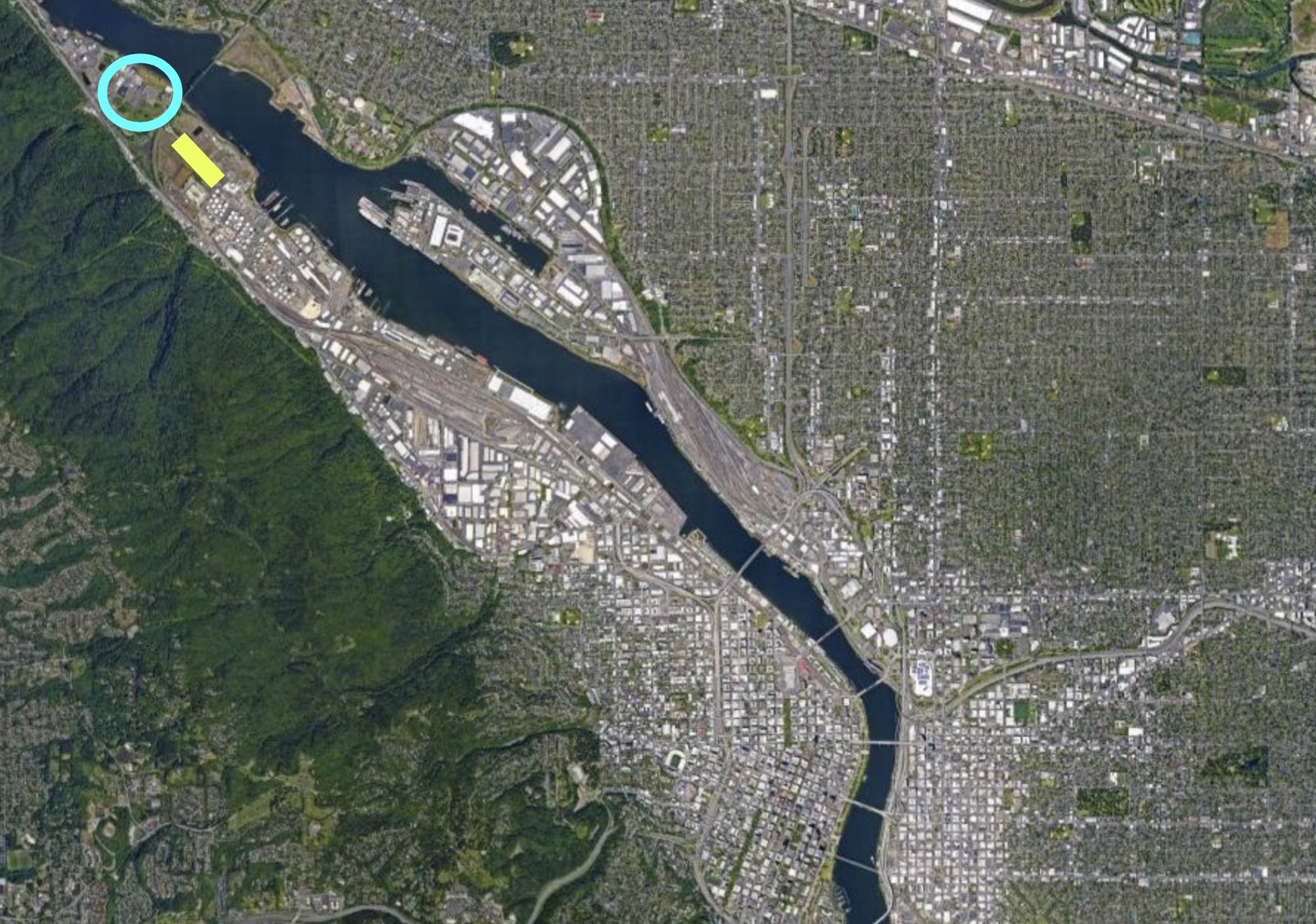
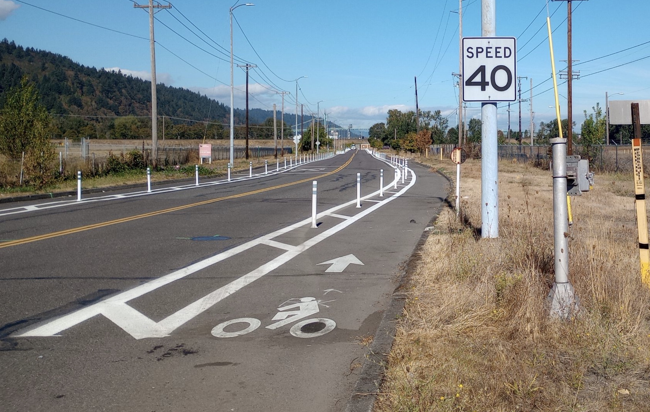
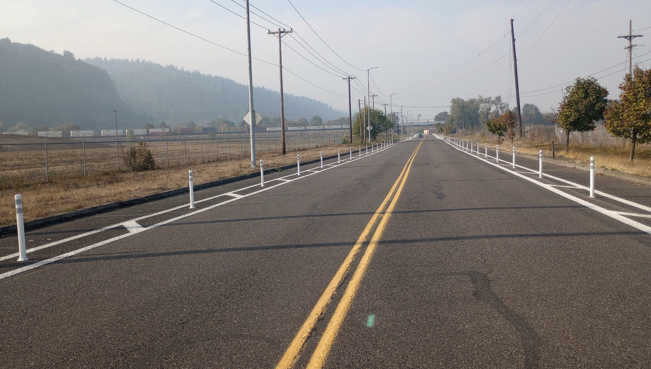
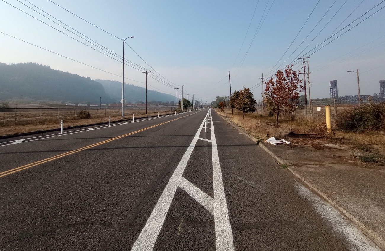
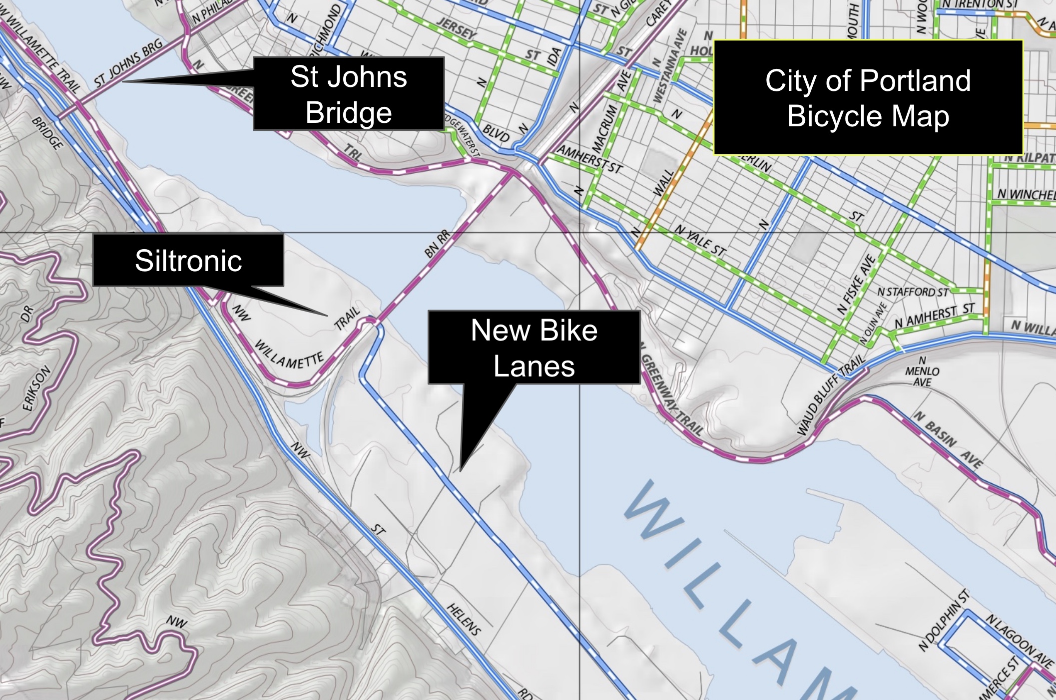
The bike lanes have been built in the far reaches of the Northwest Industrial district. Over five miles north of downtown, just about a mile south of the St. Johns Bridge on a section of NW Front Avenue just north of NW 61st Avenue.. It’s a place so empty it’s almost spooky, in a post-apocalyptic-god-I-wonder-what-type-of-hazardous-industrial-waste-was-dumped-here-100-years-ago type of way.
The only reason you’ve likely ever been near there is the Metro waste transfer station nearby (a.k.a “the dump”). When I first saw the photos, a voice inside my head said, “Wow! I can’t believe PBOT built these to prevent people from parking RVs.” I knew this this location had become a major spot for folks to camp — very similar to the large encampment of vans, trailers, and other vehicles parked on both sides of NE 33rd south of Marine Drive. At that location, PBOT recently helped clear dozens of campers from the road.
Wanting to check my hunch, I emailed Portland Bureau of Transportation spokesperson Dylan Rivera.
Rivera got back to me this week. He didn’t say anything about the campers that used to be there. He said a private company conceived of the idea. Here’s Rivera’s explanation:
“Siltronic approached us about the need for a bike lane there, adjacent to land the company owns. We found that the Bicycle Plan for 2030 does call for an in-roadway, separated bike lane on NW Front Avenue [the blue-and-white striped line in the map above]. Since the company was able to design and build it to our specifications, we were more than happy to accept this new addition to the city’s bike network.”
Siltronic is a massive, German company that makes “wafers made of hyperpure silicon, the basis for modern micro- and nanotechnology.” They employ 4,300 people and have offices around the globe. Their Portland headquarters sits on the banks of the Willamette River, adjacent the Burlington-Northern Railroad Bridge, and just north of these nice new bike lanes.
This isn’t the first time PBOT has happily accepted private help to fund and build bike infrastructure. Apparel giant Adidas funded and built the bike lanes on N Greeley Avenue in north Portland, and a developer paid for a Biketown station back in 2018.
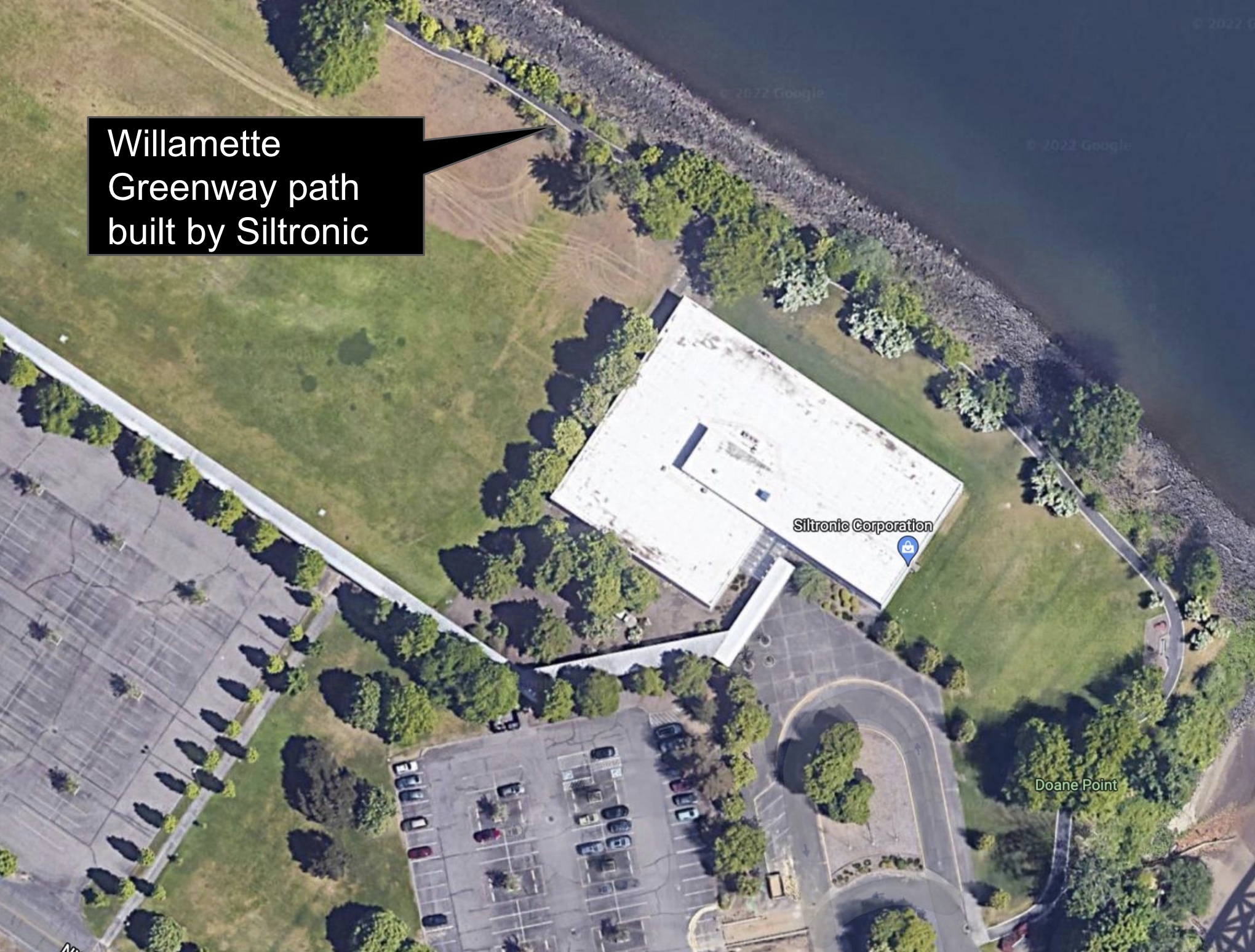
It’s also not the first time Siltronic sprung for bike-related infrastructure near their property. The last time I was at this location on NW Front I went out to inspect a beautiful piece of the Willamette River Greenway path that runs right outside their offices (see map). It’s private property, but I’ve since confirmed that they paid for and built the paths with their own contractors.
It’s no surprise that PBOT wants all the help they can get to build out our cycling network. In fact, when he got back to me this week, Rivera included a pitch for other companies to step up. “We welcome offers from landowners who want to bring their street frontages up to modern standards that will help meet the city and the community’s goals for access to biking and walking. Check the map and give us a call!,” he wrote.
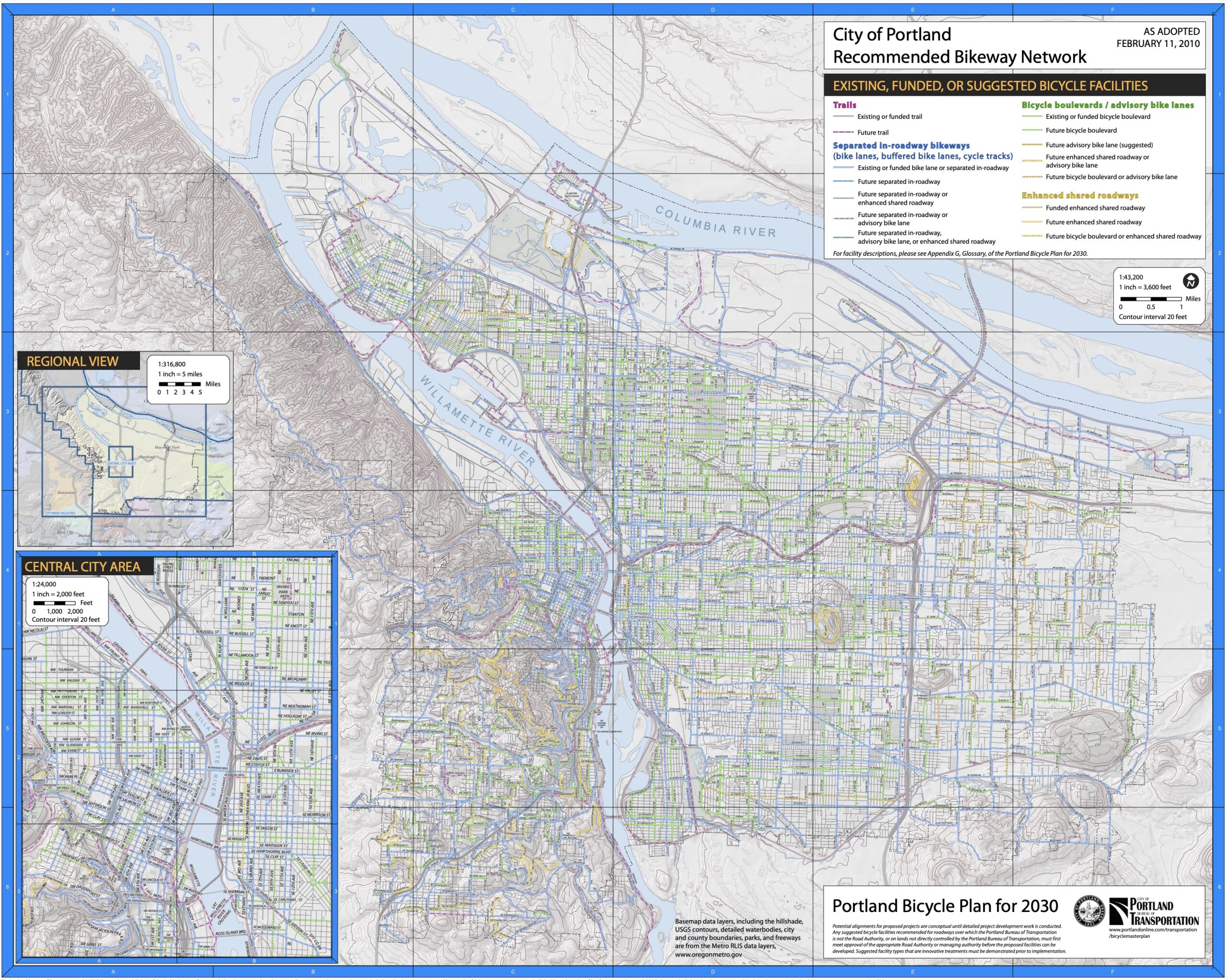
The “map” Rivera refers to is the City of Portland Recommended Bicycle Network map that was adopted with the Bicycle Plan for 2030 in 2010.
Any other takers out there?


Thanks for reading.
BikePortland has served this community with independent community journalism since 2005. We rely on subscriptions from readers like you to survive. Your financial support is vital in keeping this valuable resource alive and well.
Please subscribe today to strengthen and expand our work.
My takeaway – if you want to ensure the roads leading to/from your company aren’t cluttered with zombie RVs, let PBOT know you’ll build bike lanes. I’m all for it.
Interesting that the bike plan (from 2010) still refused to acknowledge the Burlington Northern – Santa Fe merger from 1995 (railroad bridge still labeled as BN RR, rather than BNSF). I’m with the bike plan on this, we should aspire to break up the giant railroad corporations choking our country!
Wow. A good news story about a company being a good corporate citizen and the first comment is a call for breaking up a “giant railroad corporation.” Sure, break up railroads and switch all that freight to trucks. That will certainly be an improvement. /s/
Breaking up the railroads would likely lead to more competition and lower shipping rates, encouraging more freight rail traffic. Because the US is essentially split into two geographic duopolies (UP and BNSF in the west, NS and CSX in the east), most customers only have one carrier to pick from, and are subject to the whims of that carrier. There are some efficiencies gained by consolidating the railroads like we have, but we don’t really have any evidence that those efficiencies have resulted in lower rates for customers.
https://www.nytimes.com/2022/10/09/opinion/business-economics/freight-train-mismanagement.html
How would breaking up railroads lead to more freight on trucks? Oh darn, the Class I railroads would have to maintain more than the bare minimum of their infrastructure and lower rates to remain competitive? That would be such a shame, I bet we would have so many more trucks on the road.
Thank god we have four freight rail companies in the country, each with a region of localized monopoly control. It really makes our freight rail system reliable, efficient, and easy for everyone to utilize! If we had any more, the trucking industry would just be absolutely crushing it!!
I was just making a dumb joke about a map that apparently hasn’t updated some data points since 1995.
You are on bicycle advocacy site. Making a cynical off-topic joke, railing about a train monopoly in response to a positive article about a corporation contributing positively to our city. You receive what you cast out.
I’ll rail at train monopolies any chance I’m given thanks. Not sure how it’s “cynical” to want more accountability, transparency, and competition in the railroad industry.
Does every comment on BikePortland have to be strictly discussing the meat and potatoes of the article? No room here for the silly joke? I care deeply about safe cycling and many other things, and the Siltronic bike lanes are probably good. I just think it’s funny to see old labels on maps too, and I’m not above wasting my time commenting on it.
BNSF is part of an even larger conglomerate called Bershire-Hathaway along with Heinz ketchup among others. https://en.wikipedia.org/wiki/Berkshire_Hathaway
“BNSF is part of an even larger conglomerate called Bershire-Hathaway”
Pieces of which are in turn owned by many of the readers of this blog.
Bring back Conrail, baby!
I ride between Naito and the Kittridge overpass quite frequently. That sections has bike lanes that just end end. This is a useful connection to get from Central Portland to Forest Park. I continue on the shoulder of Hwy 30 to Saltzman, but PP&R is supposedly building a new vForest Park Visitor Center right at the intersction of Hwy 30/St Helens/Kittridge, so extending the bikes to this would be logical extension.
If I understand the story, these lanes are quite bit farther north. I have a few questions: 1) Do these new bike lanes connect to anything farther south? 2)Is PBOT considering connecting to them? 3) The PBOT map included in the article implies the new bike lanes connect to a “purple” trail that continues under teh St John Bridge and beyond- where Can I find out more about this? Is there a connection to/across 30 north of the St Johns Bridge?
The Forest Park Visitor Center project has been reduced to being just a car park.
thats too bad. Probably no new mt bike trails, then.
That new car parking lot for the Forest Park visitor center is still a waste of tax dollars. High cost of free or cheap car parking.
that parking lot is being built to cover a brownfield they’d otherwise have to remediate, IIRC boondoogle with a subplot.
Is that the DEQ-approved solution? Cap and call it good? I predict they will be going back in someday to do more environmental remediation work.
I know nothing about any contamination at this (future) visitor center site, but “cap and call it good” is in fact an approved treatment for certain types of contamination. There are quite a few new apartment buildings and parking lots around town ‘capping’ contaminated soil.
South of this is a long stretch of Front Ave with no bike lanes, pleasantly traffic free on the weekends but no doubt a nightmare of large trucks during most of the week, it’s a two lane through a very industrial area until you get to the north end of the Pearl District redevelopments; there you will find new apartments and parking protected bike lanes, which do connect to downtown.
According to the 2030 plan legend, dashed lines represent ‘future’ trails/ lanes/ greenways.
That’s the kind of corporate activism I can get behind.
I applaud this too, but I dislike the way in the US the government does NOT take care of its citizen’s needs, leaving corporations, non-profits and ordinary citizens to step in. I like how in northern Europe people and corporations (with the exception of Ireland) gets taxed a lot. and lead a simple life knowing that their infrastructure and health needs are being taken care of.
Why wait for corporations to be charitable? The city can force some retirees to build a sidewalk in their neighborhood but can’t mandate that ALL corporations build bike lane for their employees to get to work?
I’m sure that hindering the camping on this stretch was a big part of the decision (just looking at the Google Maps satellite view, I can see dozens of RV/trailers in this short stretch). This is a welcome addition either way, though. Now if we can just get the path built all the way to the St. John’s Bridge…
Siltronic, vielen Dank, dass Sie Portland ein bisschen fahrradfreundlicher gemacht haben! – Portland area cyclists.
Ja, Stimmt!!!
I love that area, it’s one of my favorite parts of town. I considered applying for a job at the dump just to spend more time there.
I agree. I like the confluence of industry and nature out that way.
It’s not a dump, it’s a transfer station, and I can’t imagine working all day long with the smell.
Maybe you should apply. In all seriousness, the people who work there are great! Excellent attitude, very helpful and professional. I can’t think of a public agency or facility that’s better run or more efficient. All my experiences there with household and toxic waste disposal there have gone smoothly.
I agree, I love the place, I wasn’t being facetious. The employees are happy and fun, the place is really well-run, and the work is important.
I love the sculpture tableau as you exit toxic waste. And then there was the guy at weigh-in who always wanted a cookie.
The cookie guy! I told him I did bring cookies for him because he’d asked the time before, but that the people at the check-in booth seized them on my way in.
LOL
Perhaps this corridor got the A+ bike upgrade so that it could be used in “urbane” street scenes for bike (or car) commercials or movie scenes?
Didn’t Adidas just shift their tax burden to improve the street adjacent to their property? I thought they got some tax credit for it?
Correct. They used Transportation System Development Charge credits, so basically they paid the same amount they would have paid anyway in fees but used it instead to build the cycle-track along their frontage. So it’s not like they were being super generous or anything–they just realized they could offset their fees by building something that would actually serve their site. I’m surprised more developers don’t take advantage of that provision!
Corportations directing their taxes to improve their property values is pretty funny. Meanwhile I pay a ton of taxes and have to beg the city/county/state to keep people from going 50mph down my street.
If you pay a ton of taxes then you should pay more. We won’t be able to address ever increasing inequality and associated tragedies of the commons without the economically-secure paying their fair share.
What a silly idea. What’s the appropriate tax rate for me soren? 99%? 100%? There’s really no end to Multnomah County and the CoP and Metro sending me new shiny projects they want to do. I even voted for the homeless tax, which I now completely regret as the money is being used to just make the problem worse.
The government should be an effective steward of tax dollars and keep taxes as low as possible while maintaining high services.
I think if you had your way there would be no inequality, because we’d all be equally poor. I don’t mind paying my fair share but at some point, I’m just paying for other peoples bad decisions.
The only way to achieve that is by drastically increasing housing density and infill development. Glad you’re on board!
Along at least a mile of greenway, my block is the only one that crosses it without some sort of physical calming in either direction. We have lobbied for equal treatment and been told in no uncertain terms that you can’t even buy that sort of thing even if you wanted to. Hmm.
What I heard from a neighbor: this is in the name of financial “equity” – if not everyone can pay for calming devices, NO ONE can
In General, I am a supporter of PBOT. But how does a sentence like this appear: “We found that the Bicycle Plan for 2030 does call for an in-roadway, separated bike lane on NW Front Avenue.” – PBOT
Would we accept “We discovered that ‘putting out fires’ was in fact listed in our 1890 charter papers – Fire Dept?”
Plans constantly, expensively, obsessively made… and then forgotten.
I also note the hilarity (or tragedy) of PBOT claiming “Since the company was able to design and build it to our specifications, we were more than happy to accept this new addition to the city’s bike network” while REFUSING private offers to build infrastructure in SW, and letting developers skate on them in SW and East Portland.
When charter reform passes, I want the City Manager to unsilo this freaking bureau, inform each desk what the others are doing, and make them play nice together.
Updating to add:
“We welcome offers from landowners who want to bring their street frontages up to modern standards that will help meet the city and the community’s goals for access to biking and walking. Check the map and give us a call!,” he wrote.
HAHAHAHAHHAHAHAHHAHHAHHAHAH
Given that this is basically a bike lane to nowhere (except the Metro dump), I think it’s pretty obvious that this project was done to deter RV camping. So it’s not like a high-minded project to improve the bike network, though it’s certainly nice to have. It’s a bit more like when that property owner on NW Broadway put in all the “bike racks” on their sidewalk to deter camping.
I would tend to agree.
This is essentially part of the Willamette greenway now. Which is actually *but toothlessly* enshrined in state land use goals and in the past has been vigorously opposed by various other river-front business and property owners in the Metro area such as the Portland Spirit, Ross Island S&G, UPRR/BNSF and others. Thank you, Siltronic!
In the same spirit as using “crash” instead of “accident”, can we agree to stop calling these “protected” bike lanes?
Protection implies some sort of physical barrier that can reduce the impact of an encroaching vehicle. Flexible bollards are, by design, explicitly not that.
Referring to this kind of bike lane as “protected” sets us up to settle for substandard infrastructure. And to top it off, they’re really freakin’ ugly.
The hatched striping is technically called a “gore” by traffic engineers and civil designers. The sticks are often referred to as candlesticks, but I seem to remember designers at PBOT calling them delineators, back when they used them for directing cars only. So technically we should probably call these bike lanes “delineator-gore buffered bike lanes – DGBBL” or “gore-delineator buffered bike lanes – GDBBL” rather than “barrier-protected bike lanes”, but honestly I can’t see any of this catching on.
I call them bike jails.
It would be even worse if the barriers were something like Jersey barricades.
Comment of the week ^^^^.
Sounds like a WIN-WIN. Free bike path for the taxpayers of Portland and less dangerous RV camping! Thanks for spreading the word about it.
I ride up there frequently and the bike lanes are unusable without road improvements! They are very bumpy and I always ride in the road rather than the bike lanes.
I will say that if it deters homeless from camping up there and selling drugs openly and stripping stolen vehicles, I’m okay with the state of things as-is. There’s hardly any traffic up that way so riding in the road is not an issue. I’ve seen multiple deer up there, a beaver in the water too.
But to someone else’s point, a path to the St. John’s bridge would be amazing. I won’t ride on Hwy 30.
For what it’s worth, Front St is my preferred way to ride (on weekends only) to get off Highway 30 and practice my track-crossing skills. Nearby, on Highway 30 heading back into town, the bike lane (temporarily?) disappears for a mile or two, which is hopefully just a construction glitch but it was a terrifying reminder to me of what a big difference a little white line of paint makes over nothing.
Anyway, very glad to see this development, thanks for reporting!
Is there a newer map than Feb 2011 that shows what has been built on the 2030 bicycle master plan? I can’t wait, we only have 7 1/4 years to build out the rest!
What is coming next?
And are there any updates to the Woodlawn to Lloyd Greenway?
“a beautiful piece of the Willamette River Greenway path that runs right outside their offices”
Can someone please confirm: although on private property, this is open to the public? I’m trying to determine if one can reach the foot of the St Johns bridge ramp via Front Ave (crossing at and a very short jaunt on US30) and this Siltronic path, without riding on US30.
It is not open to the public, and one could not reach the St. John’s bridge from the path, as the path is very short.
Have you been there? I haven’t, and am interested in the details about it not being open to the public
I looked at portlandmaps.com and google, and get mixed messages. It’s definitely private property. And on google, there’s a “private property” sign right before the street turnaround and the path entrance. That makes it look like it’s clearly NOT open to the public. There’s also a red “stop” sign in the turnaround circle with something (warning?) I can’t read:
https://www.google.com/maps/@45.5753093,-122.7498972,3a,67y,304.93h,84.99t/data=!3m6!1e1!3m4!1sN_HCjMVzHVRmwIec4ZTvOA!2e0!7i13312!8i6656
But on portlandmaps, that turnaround is clearly Front Avenue and a public street: https://www.portlandmaps.com/detail/property/-13664484.461349225_5712554.089421598_xy/
That makes it look like Siltronic may be deceiving people into thinking the turnaround is private, meaning you can’t get to the path entrance where it links to the turnaround.
So once you go on the (likely) public street to the path entrance, is the path (clearly on private property) open to the public? The same trail through John’s Landing north to the South Waterfront is on private property, but open to the public, and property owners have been required to provide the trail and allow access as a development condition. It seems like that would be the case at Siltronic, otherwise why would they build it? On the other hand, I don’t see a trail designation there in the zoning maps.
I often go places that are public that owners claim are private, and have portlandmaps on my phone to show them if I’m confronted. But it doesn’t give any indication the path is open to the public. It would be interesting to follow up with PBOT, Parks, and/or BDS. If it’s supposed to be open to the public, and Siltronics is making it look like it isn’t, that’s bad. If it’s not required to be open, fine, unless Siltronic got some sort of development credit for building it without a requirement to allow public access (unlikely) in which case the City was in the wrong.
Now I really want to see what the red sign says.
Thanks qqq for researching and elaborating on the same lines as I was wondering. JM referred to it as “beautiful piece of the Willamette River Greenway,” which would be a strange description of a path not accessible to the public.
I actually don’t recall if I ever got a confirmation or not from PBOT/Parks about whether or not it’s technically public or private. I have been there to research the path and because of the “Private Property” signs I didn’t share the photos publicly. It is an amazing piece of path and given that it’s behind a gate (that was open on the weekend I was there) and the conspicuous signs, I didn’t want to push it.
But I’d like to know for sure too! I will try to do some follow up and report back.
Old post, I know, but to confirm: I went out there to ride on this path, and I got chased down by a Siltronic security guard and escorted off the property. After he calmed down a bit, he explained that the gate is open because that roundabout is public property and thus they are required to keep it open. But everything else there is private, according to him.
It’s a bummer, because it would be a great little path to get to Highway 30, if it would only wrap behind the Siltronic factory and connect up with the little east-west stub of NW Front just off the highway, on the other side of the tracks.
Hi Andy, Thanks for the response. See more in the dialog below–as qqq notes, it can be on private property but open to the public. I recognize the path itself doesn’t go to the bridge, but it appears to connect from Front Ave SE of Siltronic to Front Ave NW of Siltronic. The latter would put you onto US30 at a stop light, about 200′ from Bridge Ave.
Those flex posts will not stop anyone from parking their RV there again. And why should they? Rents are sky-high and the unhoused need to sleep somewhere.