(Graphic: PBOT)
A seasonal fix to Naito Parkway isn’t the only thing on the bureau of transportation’s fall budget wish list. With a total of $8 million in General Fund dollars up for grabs, PBOT is lobbying for several other exciting projects.
Three projects caught our eyes in PBOT’s official Fall Budget Monitoring process request (PDF here). Scroll down for details on each one of them…
Outer Halsey Safety Streetscape Project ($2,000,000)
(Photos: J. Maus/BikePortland)
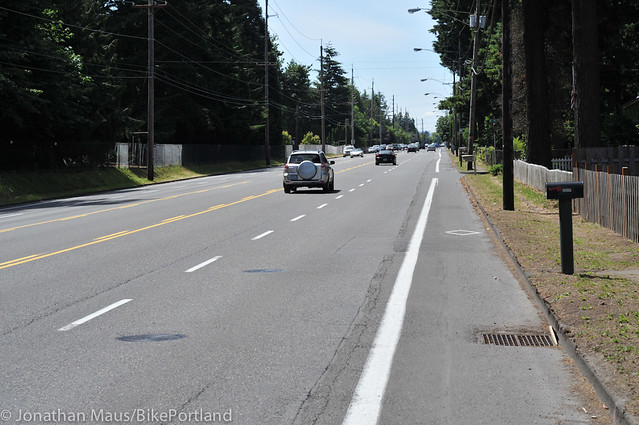
In what appears to be the largest infrastructure project ever requested by PBOT under the banner of their commitment to Vision Zero, the agency wants $2.0 million for Halsey Boulevard. The project would redesign the streetscape from 122nd (a designated high crash corridor) east to 162nd (near the Gresham border). Between 2005 and 2014 there have been 18 reported serious injury crashes and one fatality on this two-mile stretch of road. Much more funding is needed to accomplish everything PBOT would like to do here, but this $2.9 million would be a good down payment.
Specifically, the project calls for filling sidewalk gaps, narrowing existing vehicle lanes to make room for buffered bike lanes, improved crossings and a reduction of the posted speed limit from 45 mph to 35.
Vision Zero outreach and education ($900,000)

Furthering their commitment to Vision Zero, PBOT also wants to bolster their ability to communicate with the public around safety. They want funding for three new projects: $200,000 for targeted outreach around drunk driving; $200,000 for a Safe Routes to School traffic safety program in local high schools, and $500,000 to build small projects that are flagged through the city’s 823-SAFE citizen complaint line.
With 62% of all Portland fatalities involving intoxication, PBOT wants to start a Safe and Sober Streets program focused on downtown Portland. The effort will, “provide people with free rides and the option to pre-pay for Saturday morning parking.” Downtown is the focus because Oregon Liquor Control Commission data shows that area has a high concentration of bars and restaurants that overserve.
A new program to target teenage drivers in high schools would include: safe driving advertisements that reach young people through Facebook, Pandora, and other web-based media; and working with student leaders to promote safety in schools through competitions, events and other promotions. A traffic safety pep rally perhaps?
We’ve covered the 823-SAFE hotline many times over the years. It’s an excellent way to communicate with PBOT and flag safety hotspots. The city says there are over 1,000 pending requests in the system right now and with the $500,000 they’d be able to, “prioritize those community requests based on PBOT’s safety data analysis for Vision Zero.” And better yet, once projects were green-lighted they could actually be built.
Advertisement
Major fixes to SE Hawthorne Highway ($2.6 million)
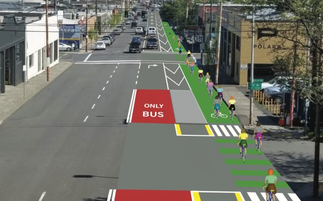
As first reported in The Oregonian yesterday, this project would allow PBOT to update the design of Hawthorne to meet today’s demands. Specifically the project would build a separated bikeway, bus transit improvements that would allow bus drivers to jump the signal queue and access stops via islands. Island bus stops are preferred over curbside stops because they help avoid the bike/bus leapfrogging that plagues many of Portland’s busy streets. Another important piece of this project would be traffic signal improvements on the entire corridor from the Hawthorne Bridge to Ladd Ave. Signals can help distribute traffic and separate modes so that there are fewer drivers tempted to make right turns in front of others.
PBOT makes the case for these upgrades by pointing out that this section of Hawthorne between SE Grand and Ladd avenues is “an important bikeway and transit corridor between the region’s economic hub (downtown) and the highest bicycle and transit use residential areas of SE Portland.” Hawthorne carries over 7,000 daily bike and transit trips. When those mix with ever-increasing amounts of auto traffic, it creates a stressful environment. PBOT calls this area “one of the city’s highest bicycle crash corridors,” with 55 reported bike crashes between 2004 and 2013.
Interestingly, PBOT has also set aside $500,000 in this project to add a traffic signal to the ramp from northbound Naito that feeds onto the Hawthorne Bridge. “A signal here would reduce vehicle delay at this location and create more regular, predictable and less stressful vehicle traffic flow for automobile traffic accessing the Hawthorne Bridge,” PBOT writes in the project description. This location also happens to be the personal crusade of local citizen activist Josh Chernoff. For weeks now he’s been posted near-daily photos and videos of people who illegally place their cars on the crosswalk that acts as the entrance onto the bridge path for bicycle riders and walkers. His latest video (below) illustrates how broken this intersection is and why i needs to be fixed:
https://www.youtube.com/watch?v=OhPQkVJU7h4
Connect the paths: Trolley to the Springwater ($300,000)
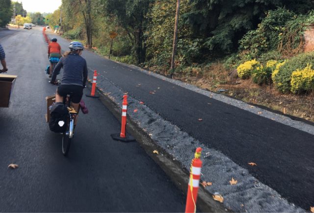
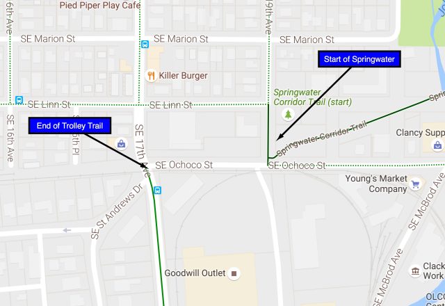
By the end of next month the City of Milwaukie will have finished building a key segment of the Trolley Trail — a separated path that runs from the Sellwood neighborhood to downtown Milwaukie on 17th Avenue. That’s great news by itself, but unfortunately the terminus of this new path will stop tantalizingly short of the start of the legendary Springwater Corridor path (see map). Thankfully PBOT is on the case. With this project they’d widen the trail and the western sidewalk of 17th between St. Andrews Drive (end of Trolley Trail) and SE Linn Street where there’s a new median refuge island crossing treatment. People could then connect to the Springwater via Linn.
While competition for city general fund dollars is fierce and PBOT isn’t likely to get all this stuff funded, it’s good to see that they’ve got these projects shovel-ready. There are other funding opportunities on the horizon.
CORRECTION, 10/21: This post originally stated that PBOT wanted $2.9 million for the Outer Halsey Streetscape Safety Project. The correct amount is $2 million. We regret the error.
— Jonathan Maus, (503) 706-8804 – jonathan@bikeportland.org
BikePortland is supported by the community (that means you!). Please become a subscriber or make a donation today.




Thanks for reading.
BikePortland has served this community with independent community journalism since 2005. We rely on subscriptions from readers like you to survive. Your financial support is vital in keeping this valuable resource alive and well.
Please subscribe today to strengthen and expand our work.
If we’re taking Vision Zero seriously, shouldn’t literally all money, on all projects, at PBOT be tied to VZ outcomes?
I don’t mean that in a pipe-dream way, but rather in a specific practical sense. VZ means every project must put safety first. If you’re not doing that — if your VZ funds are separate — then you’re not doing Vision Zero.
You’d think.
And the same could be said for climate change/leaving all fossil fuels in the ground. Hard to see how PBOT investments that are premised on continued burning of fossil fuels make any sense whatsoever (in 2016!)
Just imagine if Vision Zero and Ending fossil fuel consumption were the two drivers of our transportation policy….
Even lowering Halsey to 35mph, don’t the city’s standards call for physical protection on the bike lane here? $1.5M/mile sounds like paving money. Smooth pavement won’t get us closer to zero. Getting rid of ghost striping is one thing, but let’s just put some stuff in the road already.
Drunk education money would also be better spent on putting obstacles in the road, an approach that will actually remove drunk drivers from the roads. (They’ll be fine, just not driving that car home. If you’re afraid of someone hitting a sand barrel too fast, you need more barrels.)
As someone who drives and rides outer Halsey, I can tell you that the average speed is somewhere between 40 and 50mph. A buffered bike lane is an improvement, but these speeds really dictate physical separation. The south side of the roadway would be ideal, as it borders the gold course for a large section. The golf course also needs additional entrance points for the running trail. I think they have two or three of them total?
Curb-tight sidewalks cost $800,000/mile these days, so most of the funds are being used to pay for sidewalks from 132nd to 162nd (about a mile and a half), plus a few more crossing islands, which help slow traffic. The roadway was repaved just 2 years ago, so most of the rest of the funds are for “scratching” the old lines off and adding new ones.
The proposed project is far too timid. The current cross-section is two motor vehicle lanes each way, standard bike lanes, and a center turn lane. How about a real road diet? One motor vehicle lane each way, buffered bike lanes, and dedicated bus lanes.
30 mph should have separate space for cyclists – a bike lane is minimum.
35 is a permeable barrier, and permeable is a spectrum, from a buffer space, to vertical delineators, to parked cars, to a low median.
Above 35 requires an impermeable barrier, a wall, or raised up.
Thanks. Are those posted speeds or 11mph higher actual speeds?
Hawthorne needs to be fixed east of SE Ladd as well…
I have never heard of the Trolley Trail upgrade between Sellwood & Milkwaukie!! Any chance there will be a post on this when it’s finished? The photo looks awesome! And that segment is super-sketchy to ride currently.
Regarding Halsey, I’m curious why that particular segment was chosen? Crash data, I guess?
The reason I ask is, I feel the Halsey overpass near Gateway is honestly more important. It is the only connection over I-84 for ages, and is currently pretty much for vehicles only. The lack of connectivity around Gateway is awful.
Halsey and Glisan both suck, and they are the only option for the 3 mile section between Burnside and Prescott. I know PBOT has plans to connect the path at Gateway Green under I-205, but that still won’t help the neighborhoods between Gateway and Prescott get west of the freeway interchange…
That area is just a giant “f-you!” to pedestrians.
I can’t imagine what happens if you live at, say, NE 92nd & Schyler, and want to walk to the Gateway Fred Meyer.
Look at a map. It’s completely impossible without going about 50 blocks out if your way.
Doesn’t one of them have those stormwater gardens protruding from the sidewalk too, so that all of a sudden the cyclists are forced out into the traffic?
Glisan at about 132nd. Apparently the police cruisers regularly crash into them late at night at 90 mph.
The 17th Ave Multi-use Path, according to one Milwaukie city councilor with whom I spoke yesterday, will be finished “within days.” There is a Sunday Parkways event to showcase this new connection – and Milwaukie, in general – on October 2. I heard that the Sellwood bridge will be included in the festivities, as well.
So awesome!!! Thankyou for sharing!!!
It certainly doesn’t look like it will be finished in days at this point! It’s still bare dirt for most of its length. Will be great when it is, though.
Does anyone know the status of the project of extending the Springwater southern terminus at Umatilla up to Linn? I saw several articles that said this should be done this summer or this year (like this one- http://www.oregonmetro.gov/news/sellwood-gap-springwater-shrinking-after-metro-investments) but it’s still bare gravel.
that part of Hawthorne is the most stressful part of my commute because it’s a constant barrage of being right-hooked… this design won’t help that…
but it will help the bus leap-frog game, which isn’t as stressful…
I wish they would continue the bike lane all the way up Hawthorne to 50th…
I agree. Four lanes of traffic is odd on Hawthorne, which is such a pedestrian and bus-heavy street.
Why they don’t put a road diet in on that street I’ll never know. The lanes are so narrow, even driving a Car to Go I feel nervous I’m going to get grazed by the vehicle in the next lane over!
Two travel lanes, one center turn lane, and a bike lane each direction would work SO much better. And make the street less menacing to shoppers.
The Hawthorne Business Association is just really weird though. They dislike anything that will make it more walkable. Weirdos.
How long have you been here?
The substandard Hawthorne project was a 90’s concession to businesses. With new data to support the current layout as unsafe, PBOT has ammunition to invest in a road diet.
Right – but without the support of HBA, that’s pretty useless.
You’d hope at some point the HBBA would be seen as not representative of businesses on Hawthorne, and their views taken with a grain of salt.
Do they not represent the businesses on Hawthorne? I’m assuming their agenda is set by those businesses. Is this not true?
Paikala,
does VZ give transportation engineers/designers more latitude to deem a design unsafe and override local concerns? It seems like the status quo requires a few years of people getting hurt/killed before PBOT can justify action.
Max,
That’s how it worked in NYC. It likely depends on the politicians in charge.
Used to be a stresspoint for me, but I’ve become hooked on taking the early “offramp” down towards OMSI and then staying parallel to the MAX lines. Works well if you destination if Division or below (I actually end up on Gladstone), less so though if you are aiming for Hawthorne.
Point is, once you switch to a car separated facility, it is tough going back to the streets.
You’re right. It won’t help the right hooks. In fact, it will greatly increase the risk. Hiding bikes behind a line of parked cars in the name of safety is absurd.
As for the rest of Hawthorne, I could possibly agree to a bike lane eastbound. Westbound, from 50th, ride center lane. It’s all downhill. Between 39 and 50, cars use [part of] the turn lane to pass safely. From 39 on, there’s another lane for them to move to. IMO, a bike lane would ruin the road. A bike lane behind on-street parking is the worst case scenario.
Raised island bus stops in the middle of the road seems like just another attempt to funnel cyclists in a high cycle area into a narrow chute that moves the conflict zone from one location to another, not necessarily resolving it. These raised bump curb islands in the buffer zone will also cause crashes as cyclists hit them unexpectedly or veer to miss them.
I was wondering if the grey rectangle was in fact the bus stop. No structure/bench/shelter?
I’m sure build-out will fill the handlebar and elbow zone with benches, trashcans, signposts, and other hard physical obstructions as per standard PBOT practice.
I’m thinking that is just the “shadow” of the actual bus stop which is closer to the camera, on the near side of 6th.
To me that always looks like it’s an attempt to get bike riders to slow down…instead of the drivers.
Raised transit islands are common in Vancouver, B.C. The ones I’ve seen include a raised crosswalk from the sidewalk over to the island.
The point of the islands, as stated, is to eliminate conflict with cyclists., Also, buses can usually go through in the right only lanes, so Bus rapid Transit (little r)
Looking at the design and rationale for fixing Hawthorne at that location evokes the E end of the Tillicum bridge and its non-functioning integration into the network of streets people walking or cycling might conceivably use. Hm.
A Trolley / Springwater Trail connection would be very popular. Might give impetus to the gap between the Sellwood Br. & SE 17 Av. Improved signage for that connection would help, too. The Ladd / Hawthorne intersection and west to the bridge along the Hawthorne corridor needs that upgrade a lot. Outer Haksey, yes. Long, long overdue – renenber, many people use Halsey to get to / from Troutdale and the Gorge.
Why haven’t they filled the gap on the Springwater yet? The ROW is there. Is there some sort of property dispute, or just a funding problem?
I don’t know why the Sellwood Gap persists either. I usually just rode the wide ROW next to the tracks. A bit bumpy, but I don’t own a racing bike so it still beats the detour.
The city boundary is the center of the street. the south half is not in Portland. There’s only about 7 feet north of the curb in the public right of way.
That sure seems like a valid reason. Exactly like the way I205 stops completely before Maywood park and then resumes shortly after. Actually… it doesn’t do that. Different standards for bike projects, I guess.
The I-205 path through Maywood Park and adjacent areas was built by the County & ODOT just before Portland annexed that area, so Portland “inherited” the path.
Well, without even getting Milwaukie involved, Portland could pave the section down to Linn, and turn Linn into a bona fide greenway with turned stop signs and a diverter and an RFB at 17th. Or if the RFB is too expensive, turning stop signs on Umatilla and adding a diverter and changing the god awfully long ped/bike signal wait at Umatilla/17th would be a good step.
Right, it’s Milwaukie, the city that just built an awesome bike path that ends right at the Portland city limits, literally just a few blocks east of the spot where the Springwater turns to dirt? Is that the city?
PBOT’s cartoon image on Hawthorne shows most of the cyclists riding literally in the gutter within inches of the far curb. This is both unrealistic, but also generates a fake sense of space and width in this painted green lane in their promotional material. This is either naive on the part of their designers, or deliberately attempts to fool the public into thinking that bikes will be able to ride 3 abreast in what is currently a gutter parking strip.
Nobody should be riding in the far 2-3 feet curbside gutter zone of the green paint. It should not be counted. Riders should be shown riding at and into the buffer zone.
It certainly does show cyclists riding in the storm grate zone, and the pavement is often in poor condition in these areas, as well.
Jonathan briefly mentioned the “new median refuge island” on 17th at Linn. As someone who rides that stretch daily — turning left from NB 17th to WB Linn — I be hard-pressed to overstate how much that island has helped. Automobile drivers see the island and slow down (as if by magic!) and they are now much more likely to let me merge into traffic as I prepare to turn left.
If people start to ride up 17th on the new trail extension and then make a staged turn to EB Linn to connect to Springwater, a stop sign would probably be in order. The sightlines are pretty good, but it’s definitely an automobile commuting corridor.
How is it that we have a street posted at 45MPH adjacent to a bike lane in the first place? It costs little to ask for a speed reduction… why wasn’t that done years ago?
good question, but the revised investigation method is not applicable to Halsey. ODOT decides what the speed limit should be, and they lean heavily on 85th percentile and historic crashes, not risk of fatal.
The speed is 35 west of 137th. 25 from 114th to 100th, 30 mph west of there (per city maps).
That’s what the signs say, at least. Actual speeds are 5-10mph above that, except for a few drivers like myself, and the Trimet bus.
This is NOT an argument against doing something on Hawthorne (which I’ve been advocating for since before they repaved it years ago), but it will be interesting to see how the parking issues play out. Parking along the S side of Hawthorne is always full, and while I will not be sad to see it go away, I imagine the businesses along there will.
Parking will probably be the most visible sticking point, but as others have pointed out above, the design leaves something to be desired as well. The more I look at it the less I like it; now I’m seeing the bike lane to the right of a right turn only lane, with an improved turning radius for motorists, meaning they will be going faster than ever when they right-hook you.
>>> I’m seeing the bike lane to the right of a right turn only lane, with an improved turning radius for motorists, meaning they will be going faster than ever when they right-hook you. <<<
I couldn't have said it better.
I'll only add that with the downhill gradient, cyclists will be going faster than many drivers realize, so we have all makings for something wonderful — fast cars, fast cycles, conflicting movements, cycles approaching in the blind spot of cars, buses that will block drivers' view of cyclists, median islands that will block escape routes, bus passengers crossing the bike lane, perhaps en-masse or without looking… all the ingredients of a good old-fashioned splatter-fest.
Maybe put the buses and right-turners in the curb lane, then a bike lane to their left, with a clearly defined zone for vehicles to cross over to the turn lane, and try to disentangle things a bit.
How about bus lane in the far left lane of the road, maybe leave the parking, and remove the right lane and dedicate it to cyclists. Why can’t PBOT design a facility change on an arterial roadway thinking of cyclists first, and bus transport second? This area seems like the perfect place for this.
You forgot to mention beer trucks, uber cars, and Amazon vans parking in the green paint.
Great point — even a brief blockage of the bike lane would create a serious disruption to cyclists if there are concrete islands preventing them from going around the errant vehicle. One of the bars along that stretch has bands unloading frequently; music equipment is heavy, and the temptation to stop — just for a quick minute — while unloading would be tough for some to resist.
IT is a fair point, but buses load on the right so it would be super awkward to have bus stops on the left side of the road. I think buses serve more people than bikes, too. I actually think there is a ton of things to like about this sketch: buses are held to mid-block to not hide bikes, buses and right-turning motorist share a mizxing lane instead of bikes and right-turners, a generous buffer to the bike lane without parked cars- so better visibility for bikes and fewer ped/bike conflicts, also, only parking on the left will help slow traffic and create an increased demand for peds crossing hawthorne, further slowing traffic. The main thing I would want addressed is some king of bollard/turtle/bump/planter at the northeast corner the buffer per block to keep the right-turners moving slowly and not cut corners
1. not every block needs to allow right turns
2. turn radius is limited by the design — this one needs something more than paint
So much empty space and paint — let’s get 3D. Quite a few points there where vehicles should never be could be marked with at least a bollard or bowl of petunias.
Or maybe a larch.
Or some shrubbery, but not too small…
I’m concerned about the right hook potential here too. Most cyclists exceed 20mph coming off the Hawthorne (at least if they get the green light at Grand). Hawthorne at 6th (and 7th, AND 8th) is among the few places I’ve had genuine close calls with getting right hooked. I don’t see how this design will help, and it may hurt.
Posted something below but the idea with more separated lanes in general is so that cars cross bike lanes perpendicularly, not a sweeping merge through them while turning. While this design could go further it’s a step in the right direction to get cars to make their turn and then be facing the bike lane crossing, allowing them to see cyclists coming from their right instead of having to look for them over their back shoulder.
If they simply didn’t put a right turn lane in at all it could be a few more parking spots but mostly physically protected empty space at the intersection so that cars turning right would travel the distance of the parking lane + the buffer before crossing the bike lane. This in theory would mean the cars are at a perpendicular angle to the bike lane and can see cyclists coming more easily before they cross the bike lane. This would also give them space to wait for cyclists to pass while not blocking thru traffic in the Hawthorne lane. I like getting bikes and car further from each other and I think this has a great opportunity to do that while still keeping cyclists visible.
Induced parking demand works in reverse. Removal of the parking and improvement of other modes might prompt people to arrive by bus or bike, rather than private automobile.
Or, more likely, it might induce them to go elsewhere, were parking isn’t such a hassle. From a cycling along Hawthorne perspective, this would probably be fine. From an owning business on Hawthorne, it is less than desirable. Hence the conflict between different sets of tradeoffs that we, looking at things from a cyclist’s perspective, tend to underplay.
[It may well be the case that other customers will come that are attracted by the improved environment, but from a business POV, that is a risky proposition — the near certain loss of existing customers in exchange for the possibility of new ones.]
There is a cross-street every 200 feet that has available parking. But we all know drivers are unwilling to walk even 1 extra foot to their destination, so that idea will never work.
Well, why not talk to the business owners, who know their customers, and ask what they think? Maybe there are additional considerations that your pat answer ignores?
I support parking removal in this case, but I don’t pretend that there are not legitimate reasons for opposing it.
Why not talk to the customers instead, since they know themselves better than the business owners do.
Indeed, this would be a great idea. If the customers told the owners that they supported the idea, then the owners might get on board.
Great, I’ll let Clever Cycles know.
Please report back — I would be interested in their reaction.
I don’t want to make any assumptions, but I would imagine a good portion of their customers arrive by bike.
Yes, they support it.
Right, but it goes deeper than that. Businesses generally want the appearance of being accessible. That, I think, is why the old transit mall failed. Most customers who drive downtown will park elsewhere, but the mental notion that there is “no parking” makes the business seem less available.
Clever Cycles is, I think, the only bike oriented business along that section, and I could see that even they might be uncomfortable. Or they might not, but you might learn something by talking to them. You’d certainly learn more by talking to the other businesses there.
Seriously — if you do talk to any of them, report back.
RE: Hawthorne: I don’t get PBOTs bizarre aversion to physical separation of the roadway!
Thousands of people are moving here daily, bikes are expanding in popularity, why hamstring our growing population density with these ridiculous “buffered” bike lanes. They are a waste of valuable real estate and do nothing but provide the illusion of safety.
It is not like we are going to be expanding ROW anytime soon on Hawthorne. It is way past time PBOT stop squandering it’s capacity to move everyone safely.
good point, but how would you like to see the space used? Another driving lane only makes the street harder to cross. Use the buffer for parking and you have increased bike/ped conflicts.
Personally, I would love to see another row of street trees and 5′ sidewalk that would act as a refuge for peds crossing and a clear way for people to get to the bus islands. THere would also be space for some stormwater planters here that would go along way toward keeping the bike lane clean! I would love to hear you thoughts.
Those are all great ideas. Leaving it vacant with painted designs does nothing but look good on paper.
maybe, cost?
The Trolley Trail link down Ochoco to the east bound Springwater is a slam dunk. The distance is only a few hundred feet. The missing link of the Springwater from where it ends at Ochoco and where it picks up under the Sellwood Bridge will, sadly, be a tough nut to crack. The prevalence of homeless and their behavior of abysmal stewardship of the land is more than enough reason for neighbors to want no part of linking the missing link. Add to that there has been enough criminal behavior by the homeless along the Springwater, both between themselves and into the neighborhoods, to warrant sweeps and the fact that fires started in homeless camps create a hazard to persons and property, and that their human waste is a health hazard, combine into the fact that they are not desirable neighbors. The upscale Garthwick neighborhood and the (now) middle class south Sellwood neighborhood are agreed that they don’t want homeless camps. It has become a fact that the Springwater Corridor has become synonymous with homeless camps, so if one does not want those camps, then prevent Springwater Trail connection.
This.
If you regularly get hooked, you need to examine what role your own actions play. I ride the same streets as everyone else, including this stretch (most recently last night). I haven’t been hooked for so many years I couldn’t say how long it’s been. On the other hand, it seems like I see others get hooked almost every day.
The vast majority of the time, motorists telegraph when they’re going to turn in. Even when they don’t, you should be ready anyway.. Good drivers don’t assume everything will be fine and everyone will do what they’re supposed to. Same is true for cyclists. That’s just defensive cycling/driving.
I’m all in favor of making things safer, but constantly droning that things are unsafe because we aren’t separated out feeds right into the narrative that bikes don’t belong on the road. Failing to take reasonable ownership of our own safety gets people hurt and perpetuates attitudes that cycling is unsafe.
I cycle the way you do, with an abundance of alertness and attention to drivers around me. But until we make cycling infrastructure good enough that inexperienced cyclists can be safe and comfortable as well, cycling for transportation will always be a niche activity. PBOT’s policy is to design bike infrastructure suitable for 12 year old riders. This means we need facilities that prevent right hooks by design, not by cyclist vigilance. It is eminently doable if we can find the political will.
There are too many intersections and driveways to get them all, but we can certainly improve areas that have disproportionate problems. There are a wide variety of other threats, some which are easier to mitigate with infrastructure than others.
I’m surprised the BP community doesn’t take great issue with PBOT’s goal infrastructure suitable for 12 year olds. I regularly see kids riding on real roads. As a group, they exercise more common sense and do a better job of riding defensively than older riders. If the idea is to build for the most vulnerable riders, the infrastructure should probably be made suitable for 20 or 30 somethings as that demographic seems to struggle the most with vehicle conflicts.
I take issue with the 12-year-old objective but in the other direction – I think our infrastructure safety/comfort should be AND FEEL safe for a 6-to-8-year-old on their own bike. Yes, 20- and 30-somethings are dumb too and at higher speeds and longer distances but we are a group that inspires less sympathy. Design speed should be set with adult riders in mind though.
PBOT has a design speed for bike facilities? I thought everything was just done with a 5ft stick.
I don’t know if Hawthorne is a great idea for small kids even if this project goes through, but I have seen them there before and I sometimes see them on Interstate. If you go to streets that are outright bike friendly like Clinton, you’ll see them all the time.
One thing that occurs to me as I write this is I’ve seen a lot of small kids riding, but I’ve never seen one do anything I thought was dangerous nor did I have any concerns for their safety. Quite the opposite — I find myself impressed both with their traffic and handling skills (speed too, especially when you consider they’re typically on wide knobbies on bikes that are 1/3 of their body weight).
I’ve always maintained that telepathy is a fundamental cycling skill.
Those darn kids being hit by drivers should take reasonable ownership of their safety!
And please, can we stop wasting money teaching people to drive defensively??? It’s not my responsibility to prevent you from crashing into me, so why should I take any special caution to prevent it?
The design for Hawthorne looks great and is badly needed. Though, it would be better to make the entire buffer concrete rather than just the bus islands. This could be a good place to deploy the self-watering planters used on 2nd Av.
Don’t get me wrong — I favor making things safer. But advances in infrastructure and driving practice occur very slowly. Helping people be safe in the environment we actually have has to be part of the game plan.
As a community we do virtually nothing to encourage safe behavior. I would go so far as to say we practically encourage a wide range of dangerous behaviors that cyclists in other areas don’t do.
For example, this morning, I saw cyclists pull on the right side of turning semis after the light turned green both at Interstate and Going and just a bit later at Interstate and Tillamook. In both cases, they got blocked off because the driver did not think to look to the right for cyclists that weren’t there when the light was red, but caught up with them when the light turned. On Broadway, I think it’s safe to say I see people do similar moves every single day — and I see a lot of close calls. This is incredibly dangerous and slows the cyclists and drivers down to boot.
Let’s suppose for argument’s sake that 99% of drivers are awesome and the other 1% are bad for whatever reason (I suspect the real number of bad drivers may be higher). Given how many vehicles you encounter, who thinks taking that 1% bet is a good idea? The math is guaranteed to catch up with you.
And teaching a large percentage of people in the bike “community” to bike more safely can realistically happen quickly without discouraging cycling? The only ways I can think of to reach a large percentage of people who bike are to include robust cycling education with driver’s license renewals (to get existing adults, at least those who have driver’s licenses) and to include cycling education in schools (to get kids). Both those are huge, state-level lifts. I actually think re-doing the City’s infrastructure is easier politically than teaching everyone how to bike more safely and also has the added benefit of encouraging people to bike.
Classes are not what is needed. If you want more people doing it, help them understand how easy and safe it is.
I’ve helped many people get started cycling, and workmates, neighbors, and friends have asked me for advice about all aspects for many years. I’ve ridden in all sorts of environments to help kids and adults alike wrap their minds around how to navigate different environments. When cyclists and noncyclists alike share their thoughts in regular conversation, that is an opportunity to help.
Teaching people that cycling is dangerous and that their fate rests in the hands of irresponsible strangers discourages them. Not informing them that they should be ready for cars to turn in front of them leads to scary situations that discourages them. Encouraging them to not work with motorists will lead to confrontations that will discourage them. Not making sure they know how to monitor what’s going on behind them will keep them fearful and lead to unpleasant surprises.
What appears to be standard BP cycling practice sets people up for failure. If you help people have fun and be safe rather than feel victimized and unsafe, they’re much more likely to ride.
I hate to inform you of this, but BikePortland readers are a small subset of people, most all of whom already ride but not even close to a majority of Portland bike riders, and who have many different ways of talking about riding, even within the same person. I can code-switch and talk about the benefits of approachable rides with a new rider and things to watch out for in a positive way while telling truth to power and within our own echo chamber about how unacceptably slow progress is, and how riding will never be a mass activity until the outside environment – infrastructure and how people drive – is more welcoming. It’s not an either/or.
Why on earth is it a good idea to spend millions on a tiny section of road that’s easy to ride and already has bike infrastructure when there is nothing on the exact same road literally on the next block?
There is no bike lane once you clear 12th. At that point, you’re going uphill, the cars and lights are more spaced out so traffic speeds pick up quite a bit. The traffic acts different too. Go a little further on this same street and you get to where that girl was killed.
Wait, how did we change subjects from how people talk about biking on BP to the proposed Hawthorne project? Personally, I think the Hawthorne money/political will would be better spent making the Halsey project actually be safe for people to cross the street but that’s just me.
Given your stereotyping of advocates on this blog I suspect that it will come as surprise to you that I also do not support spending $2.6 million on Hawthorne when the need is so much greater elsewhere.
Thank you for featuring my efforts, I’m optimistic that any effort to do something there will make it better. While a light is fantastic I would love to see them join the two crosswalk and make a unified crossing for both peds and cyclist to make it easier for car traffic to cross the path.
Instead of buckets with crossing flags, maybe we could have buckets with crossing bricks and u-locks.