
(Image: Google Street View.)
Four months after saying it had no plans to do so, the Oregon Department of Transportation will formally consider the possibility of new changes to a two-mile stretch of Barbur Bouelvard where six people have died in cars, on motorcycles and on foot in the last six years.
“The audit will consider a road diet as a potential safety tool in the corridor.”
— ODOT
ODOT’s announcement of the new analysis to be launched this summer by a team of multi-agency experts came Tuesday after years of pressure from some Southwest Portlanders and other safety advocates including the Bicycle Transportation Alliance.
“Many residents of House District 38 use Barbur every day to travel to and from home, work or school,” said Rep. Ann Lininger in ODOT’s news release Tuesday. Her district includes much of Southwest Portland on both sides of Barbur, Lake Oswego and other communities southeast of Barbur. “I am very pleased to see ODOT initiate the Road Safety Audit and further its commitment to improving safety for all users on this crucial roadway.”
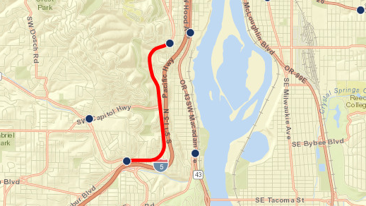
The stretch of road up for analysis runs 5.6 miles from Barbur’s southern intersection with Capitol Highway to its junction with Naito Parkway.
Near the northern end of that line are two miles through a wooded section of Barbur, where the lack of signals or significant intersections means that a northbound passing lane could be removed without major loss of roadway capacity.
However, ODOT engineers said in an interview Tuesday that changes to the two-mile section between the signals at Southwest Miles and Southwest Hamilton might lead people to merge into the left lane further south, which could then reduce signal capacity at Terwilliger and Miles. They said they haven’t yet done enough analysis to know how much delay that might add, though ODOT’s analysis of last summer’s construction on Barbur suggested that it might add about one minute during the morning rush hour on the busiest weekdays, Tuesday through Thursday.
“The audit will consider a road diet as a potential safety tool in the corridor,” ODOT wrote in its news release Tuesday.
ODOT regional manager says any changes might come in next three years
(Image: Portland State University PORTAL system)
ODOT spokesman Don Hamilton said Tuesday that road safety audits follow a procedure spelled out by the federal government to get outside experts’ eyes on a problem.
“It is not anybody from ODOT Region 1, but it could include people from cities or counties,” Hamilton said. “The idea is that we bring in independent people, we show them what we got and they then do the study. At the end of it there is a findings meeting where they present a report to the owner. In this case, that’s us, and we will then respond to that in some way.”
Alongside ODOT’s news release came a letter from ODOT Regional Manager Rian Windsheimer to Bicycle Transportation Alliance Advocacy Director Gerik Kransky, a response to the 721 signatures delivered to ODOT by the BTA last month.
“My goal is for the RSA [road safety audit] to identify improvements that will benefit all modes and help us prioritize where to spend our limited funds,” Windsheimer wrote. “If the audit identifies opportunities we feel are a higher priority than the projects we currently have programmed in the 2015-2018 STIP [statewide transportation improvement program], we may want to consider revisions to the scope of those projects to include higher priority locations or elements.”
“I think it’s welcome news from ODOT that they’re listening to the community conversation about safety on their roadways,” Kransky said Tuesday. “I am eagerly awaiting an announcement regarding who will be participating.”
Advertisement
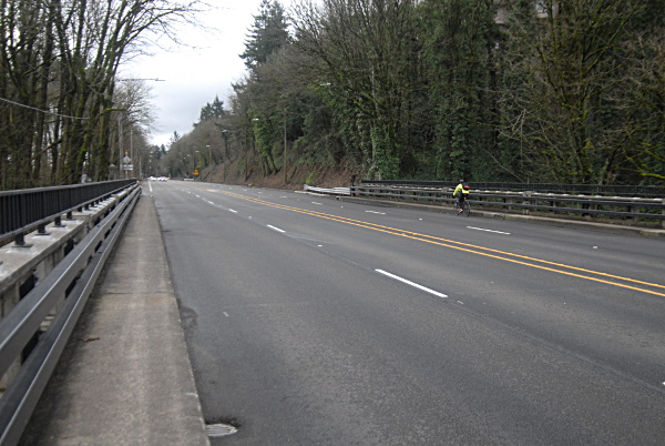
The BTA, Oregon Walks, City Club of Portland, Lewis and Clark College, the Markham Neighborhood Association, Southwest Trails and a handful of local businesses have urged a study along these lines, including the possibility of restriping Barbur to remove a northbound passing lane and add continuous protected or buffered bike lanes and/or walking lanes across two narrow bridges on Barbur where the bike lanes disappear, forcing people on bikes and cars to merge into the same 45 mph lanes.
For people biking, it’s by far the flattest connection between most of Southwest Portland and the rest of the city.
“We’re cautiously optimistic, definitely welcoming the conversation and hoping that it leads us directly to protected bike lanes over the Newberry and Vermont bridges,” Kransky said.
Neighborhood groups hopeful
Other advocates for the safety of driving, biking and walking on Barbur also voiced cautious support.
“I’m excited for a chance for the community to weigh in on Barbur, and I hope that people will get involved,” said Kiel Johnson, an organizer for the local safety group, Friends of Barbur, that gathered 502 of the signatures delivered by the BTA. “I think it’s a pretty easy case to make to reduce speeding and make it safe for all modes. … I just hope that it’s transparent and anyone who wants to weigh in gets to weigh in.”
Roger Averbeck, chair of Southwest Neighborhoods Inc.’s transportation committee and a prominent voice for safety changes to Barbur, said he was pleased that Windsheimer had invited him to participate.
“Those sorts of thing have been done before on urban corridors in Portland such as 82nd Avenue, Powell Boulevard,” Averbeck said. “They are helpful.”
Hamilton said the safety audit process, which takes place this summer, will involve multiple days of “people crawling all over this area” to observe road behavior and wed it to the state’s trove of speed, safety and capacity data. “It involves real hands-on observation,” he said.
Hamilton said the list of participants isn’t fixed yet but that the audit will include “people from outside the region.”
The news release mentioned “law enforcement, fire and rescue, neighborhood representatives, transit providers, bicyclists, pedestrians and ODOT” as stakeholders.
Hamilton said he didn’t anticipate a formal public hearing as part of the process but that “there will be something” such as a live or online open house to gather more input from the public at large.


Thanks for reading.
BikePortland has served this community with independent community journalism since 2005. We rely on subscriptions from readers like you to survive. Your financial support is vital in keeping this valuable resource alive and well.
Please subscribe today to strengthen and expand our work.
Good news.
A 4 lane highway without buffered pedestrian/bicycle protection is just asinine. ODOT should stop short changing Portland and reduce the risk.
“However, ODOT engineers said in an interview Tuesday that changes to the two-mile section between the signals at Southwest Miles and Southwest Hamilton might lead people to merge into the left lane further south, which could then reduce signal capacity at Terwilliger, Bertha and Miles. They said they haven’t yet done enough analysis to know how much delay that might add.”
The delay will be less than 30 seconds. If anyone is stupid enough to merge into the left lane prior to Terwilliger when the right lane doesn’t end until well after Miles, we shouldn’t be too concerned. That person is probably causing traffic delays already.
They are already coming out with the excuses on why they can’t do it. Why waste our money on a study when they already know they don’t want to and most likely won’t do it.
I have to agree:
““It is not anybody from ODOT Region 1, but it could include people from cities or counties,” Hamilton said. “The idea is that we bring in independent people, we show them what we got and they then do the study. At the end of it there is a findings meeting where they present a report to the owner. In this case, that’s us, and we will then respond to that in some way.”
They’re going to make sure they get some rural auditor that will have no urban experience. They’re setting up the process to be biased by ignorance of multimodality.
Nevermind that the capacity of Barbur north at Terwilliger is already reduced–by the idiots turning left onto Terwilliger that block the intersection because they just have to pull their car into the intersection with nowhere to go when the light changes.
FYI: since Chris posted this, I’ve looked back at last year’s study and changed this paragraph a bit. That study found 60 seconds of additional travel time, including the impacts of people slowing down for the construction zone as well as any additional crowding at the signals.
In that case the question is, Whose minute is worth more than the entire rest of your life?
The writing is on the wall for focus on safety and reducing deaths over moving cars as quickly as possible. If ODOT is committed to safety this is a good place to start. If not Barbur then where?
Hwy-101?
Not just a life and safety concern but tourism dollars.
Were talking MONEY here; we can’t scare away the tourists!
The future Red Electric Trail needs a connection from SW Parkhill Drive to SW Slavin Road. Barbur would likely connect them.
“Experts from outside the area” worries me. They have even less experience dealing with bike traffic than the people we have here unless they invite some experts from europe.
Our good-old-boy buddy from Grants Pass sure will have bike interests and vision zero in mind. -rolleyes-
let’s push them to invite some outside experts from Amsterdam, Copenhagen, London, or another metro area that gets it. That would make much more sense than someone from a rural and therefore dissimilar area.
Is Europe really that similar though?
Why would they only consider closing a northbound lane? Closing a southbound lane at capitol hwy would be super simple and easy: exit only except bikes. Aren’t most of the collisions due to southbound speeding?
Southbound is an uphill grade. In cases like these, they tend to close one of the downhill lanes, as slow-moving vehicles climbing the hill are not an issue.
Eric has a very good point though. Normally the downhill passing lane might be logical, but in this case the southbound lane might make more sense. The “I-5 relief” purpose that ODOT loves really only relates to northbound. And traffic is very light southbound beyond that B-H split. Then north of the B-H merge, a northbound lane (there are 3) would be the obvious diet.
Did they say they are only studying a northbound lane, or is that just Michael’s words? (I can’t access the press release).
You may be right. As long as the southbound 2nd lane picks back up before the light at Miles, it wouldn’t create any delays.
Finally! I’m very glad with this decision.
How many more studies are needed?
Approximately as many as ODOT deems necessary to tire their opposition.
How many holistic multi-modal life-cycle cost analysis studies have been conducted?
with Health Impact Assessment…
None, and this summer’s ODOT study doesn’t look like it is currently slated to include any of those elements either. Sounds like we still need some more protests!
Thus a road diet, rather than a median LRT, enhances the logic of Barbur BRT. Sylvania served more conveniently. New sidewalks at intersections. Same LRT/BRT bridge over I-5 into Tigard then Tualitin and/or Hwy 99 to King City if the WES corridor one day adds LRT Beaverton/Tualatin.
MAX Tualatin-to-Beaverton-to-Portland?
I want better bus stops and more bus service.
This would be a great opportunity for a fully separated, as in with a 3 foot concrete barrier, bike and pedestrian route. It can be shared by both North- and South- bound bikes. Make it safe and unintimidating.
Well, about time. Also duh. Any traffic engineer knows that an intersection-free segment that long doesn’t need as many lanes as a stretch with intersections.
As long as there is additional public Right of Way available, I would suggest installing prefabbed concrete or aluminum walkways on a higher elevation than the road and somewhat higher than existing sidewalk. This is how the Hawthorne Bridge was reconfigured to give peds and bikes a wide path that also has a high curb on the traffic side. On the two bridges that are a choke point— build extra wide walkways on the downhill (east) side and also move the railings out. This should make a reasonably wide path at least somewhat grade separated from the road traffic, that probably would have mostly cyclists but could be used by pedestrians. Of course, there would have to be street crossings that return back to the road level, and in some places where private property is close to the existing road the path would be narrower. But as long as there is publicly owned right of way available—and I think that along most of this stretch of Barbur there is–why not make use of it with prefabbed trail sections? The Hawthorne Bridge is a great example.
Any updates on when this is actually happening?
ODOT’s Jessica Horning writes that she heard this earlier today:
“We are in preliminary phases of getting a consultant on board and selecting RSA team members and resource members and stakeholder members. We have not yet set the exact week we plan to accomplish the work. We anticipate it will be no earlier than the week of July 13th and no later than the week of August 10th.”