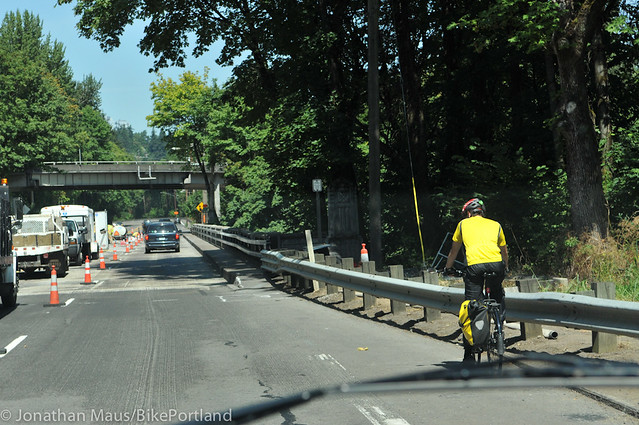
(Photo: J.Maus/BikePortland)
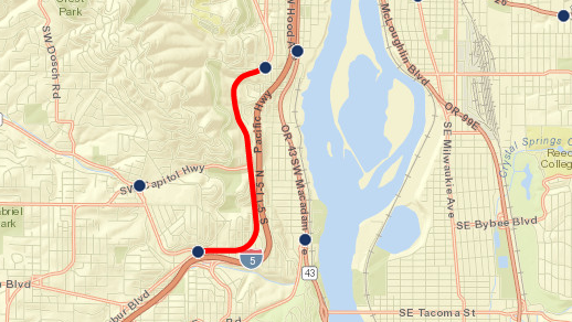
Converting one northbound traffic lane on 1.9 miles of SW Barbur Boulevard to two protected bike lanes with sidewalks would apparently prevent unsafe weaving during off-peak hours without massive impacts to morning traffic.
That’s one conclusion from data released Friday that analyzed changes to people’s driving habits during construction work on Barbur this summer. A repaving project had temporarily closed one traffic lane in each direction.
The study, led by the Oregon Department of Transportation because Barbur is a state highway, found that temporarily narrowing Barbur to two lanes at this point had added 68 seconds to the average northbound rush-hour trip.
However, that delay — a slowdown of about 23 percent for the length of this 1.9-mile stretch of road, from about 30 mph on average to about 24 mph — apparently bothered almost no drivers enough for them to switch routes.
(Image: Portland State University PORTAL system)
Moreover, the proportion of northbound drivers who had been speeding at 55 mph or faster through this stretch during non-rush hours — often by weaving rapidly through midday or early evening traffic — plummeted 68 percent during the lane reduction, according to the same data set used in the study.
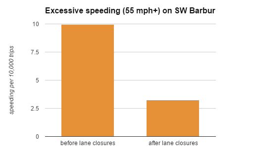
(Data via ODOT study. Chart by BikePortland.)
Southwest Neighborhoods Inc., Lewis and Clark College, the City Club of Portland, Oregon Walks and the Bicycle Transportation Alliance have all urged for study of a redesign of this frequently deadly stretch of road, which last year accounted for three of the city’s 35 traffic fatalities.
Barbur also happens to be the only relatively flat connection between most of Southwest Portland and the rest of the city. It currently forces people biking and driving to merge into the same 45 mph travel lane as they cross two narrow bridges, or else to ride up a ramp onto a 3.1-foot-wide “maintenance walkway” that also functions as the closest thing to a sidewalk.
But ODOT last year rebuffed calls to redesign Barbur, citing “strong objections from stakeholders.” (As far as ODOT’s records showed, this was apparently a reference to one key stakeholder: the Portland Business Alliance, which is the region’s chamber of commerce. Seventy-nine percent of input the agency received on the issue was actually in favor of a road diet study.) The state agency publicly predicted “unacceptable impacts” on future travel times and neighborhood traffic if one of Barbur’s northbound lanes were closed to cars and trucks.
After much debate, ODOT agreed to this summer’s study not of an actual road diet but of changes to traffic patterns during the road work.
The results offered some ammunition for people on each side of the argument.
Weekday morning traffic delay: 68 seconds over 1.9 miles

On one hand, the study found that the road work did indeed slow traffic: by an average of 68 seconds (30 percent) for northbound traffic on Tuesday, Wednesday and Thursday mornings. Closures added as much as 108 seconds (48 percent) during the busiest half-hour of those mornings, which was 8:15 to 8:45.
This was somewhat heavier than expected. Last year, estimates from two different software programs had predicted traffic delay of only 11 to 34 seconds (5 to 15 percent) in the event of a road diet.
Traffic is typically lighter on Mondays and Fridays, so rush-hour travel didn’t slow as much on those days. ODOT chose to omit these days from their study; it’s not clear why. ODOT also omitted data from the fastest 15 percent and slowest 15 percent of road users, considering them outliers.
Both of these choices had the effect of increasing the average travel delay reported in ODOT’s study. Had the agency merely averaged rush-hour speeds across all weekdays, it would have found that road work led to a 20-second (9 percent) average delay for northbound traffic.
Advertisement

Little sign of traffic diversion
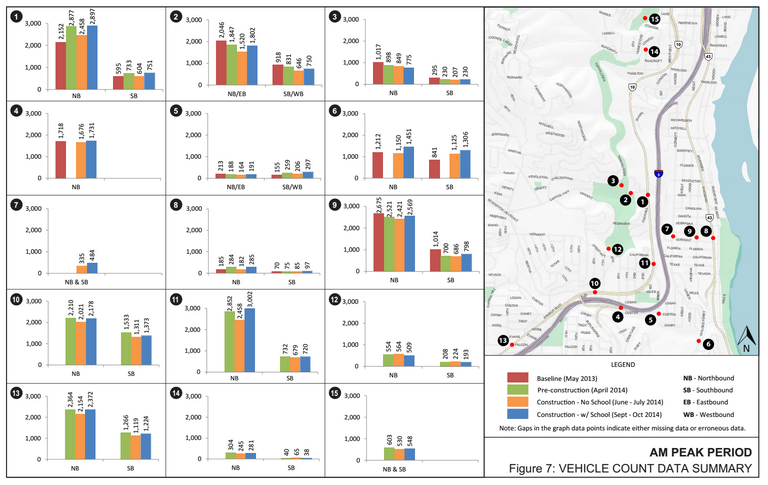
(Image: ODOT)
On the other hand, ODOT’s study found that very few people seemed to bother with using other routes to avoid the construction zone.
This had been a major concern for some neighborhood advocates. ODOT had predicted that 5 to 20 percent of Barbur traffic would switch onto other streets. No such shift was observed, however; traffic counts on Barbur were virtually unchanged during comparable periods, as were those at 12 nearby locations that might have been alternative routes.
Another significant discovery wasn’t mentioned in ODOT’s initial report but was visible in an analysis of the same data: speed data suggested that the biggest safety benefit of a road diet — preventing extreme speeding by making it impossible for the most reckless road users to weave their cars back and forth between lanes — worked well during the June-July lane closure. The percentage of cars observed moving faster than 55 mph fell from 10 per 10,000 to 3 per 10,000.
What’s more, all of the cars moving faster than 55 mph during the lane closures were doing so between midnight and 7 a.m., presumably because there were few other cars on the road. In April, when all four lanes of Barbur were open, more than half of extreme speeders were doing so between 8 a.m. and 9 p.m.
The speed tests were conducted using devices that detect Bluetooth signals, so they represent only a subset of Barbur traffic: for the pre-construction period, the data came from 13,032 Bluetooth signals captured over 30 days; during construction, from 15,457 Bluetooth signals captured over 31 days. (You can explore the data for yourself here.)
Five reasons traffic slowed; only one would apply to permanent redesign during rush hour

(Image: Google Street View.)
Why did rush-hour traffic move more slowly during construction? It’s hard to know from the data, but it’s presumably from some combination of these five factors:
1) Congestion during rush hour. Some of the change was probably due to two relatively crowded lanes merging into a single one.
2) Auto drivers getting stuck behind bicycle riders. For part of construction, people in cars and on bikes merged into a single lane, so drivers may have had to queue up behind bicycle riders. This wouldn’t happen if bike lanes were added.
3) Less weaving. With only one lane in each direction, people wishing to speed couldn’t weave between lanes to do so. This probably had little effect during rush hours, when Barbur is already crowded enough to prevent speeding, but a larger effect for the rest of the day.
4) Lower speed limit. During construction, the posted speed limit was cut from 45 mph to 35 mph, with warnings of increased enforcement and higher penalties. This might or might not apply in the case of a permanent redesign.
5) People in the work zone. The presence of road workers probably helped slow traffic, ODOT spokesman Don Hamilton wrote in an email Monday. This wouldn’t apply in the case of a permanent redesign.
One argument the Portland Business Alliance had mounted against a road diet was that the extra lane of Barbur is needed as an escape valve in case of a major blockage on Interstate 5. However, no such blockages happened during any of the periods studied.
“Therefore, we did not have an opportunity to measure the impact from such an event,” Hamilton wrote Monday.
BTA calls for separated lanes and sidewalks

(Rendering: Owen Walz)
In a blog post Friday, the Bicycle Transportation Alliance said Friday’s study “validates” the community’s “call for safety.”
“Their preliminary numbers on delays suggest that there’s no reason not to do the road diet,” BTA Advocate Carl Larson said in an interview Monday. “There was predicted lots of diversion, which is not what we’re seeing.”
Larson noted that this study looked only at the impacts of a work zone, not of a permanent road redesign.
“This is really preliminary information that we’ve been given, and it suggests, from what we understand, a road diet would go even more smoothly than the construction zone did,” Larson said.
He also questioned whether it even makes sense to be worrying about traffic delay on a street that has seen so many fatalities and injuries of people in cars and on bikes.
“We’re just focusing on trying to make the road safer,” Larson said. “From our perspective, you can’t pit safety against convenience.”
The BTA’s annual New Year’s Day ride will focus on their call to fix Barbur. The organization has also circulated a petition calling for “immediate construction of new physically separated bike lanes and sidewalks on SW Barbur.”


Thanks for reading.
BikePortland has served this community with independent community journalism since 2005. We rely on subscriptions from readers like you to survive. Your financial support is vital in keeping this valuable resource alive and well.
Please subscribe today to strengthen and expand our work.
Time to join the reality-based world, PBA and ODOT.
The future Red Electric Trail needs a road diet for these Barbur bridges in order to help people connect to SW Slavin Road.
SW Trails has asked for many improvements along much of SW Barbur Blvd.
Given the safety benefits demonstrated by the two lane configuration, and given the fact that there was little to no diversion, the onus now lies squarely on ODOT to explain why they need any more than one general lane in each direction.
ODOT can now finally tell us: do they care about saving seconds or saving lifetimes?
If ODOT still refuses to take this seriously, then the next time someone is senselessly killed on Barbur, this study will hopefully provide grounds for a lawsuit that forces them to join the 21st century. It’s pretty much negligence at this point
Angela Burke’s death was one of the many deaths it apparently took for ODOT and others to change priorities.
“If ODOT still refuses to take this seriously…”
Wanna bet they will continue to interpret these results the same way they have in the past? ODOT is not the least bit interested in people. They are beholden to certain monied interests and some obsolete cars-only formulas.
This is a fantastic piece of work, Michael. Thank you.
I don’t really get why the PBA or its members would spend time worrying about one little road diet, but nonetheless, wouldn’t it be possible to to grab the list of members and create a petition to boycott that vast majority of them until the PBA is forced to change its stance? Then with PBA out of the way, turn the focus onto ODOT ( weakened by the lack of from the PBA ), utilizing pressure on PBOT to make good on vision zero promises, etc.
> wouldn’t it be possible to to grab the list of members and create a petition to boycott that vast majority of them
You may find it even easier. This could very well be a stance pushed by a small group of PBA members; if you start by asking PBA member organizations if they’d prioritize lives over seconds and they say yes, you can then ask if they knew that the Alliance leadership has an opposite prioritization, and follow up by asking them to sign on to a petition in opposition to the PBA’s position.
That could be a win in two ways: 1) weakening the PBA’s position by showing how out of touch they are with their own membership, and 2) helping organizations rethink why they’re even part of the PBA if it doesn’t reflect their values.
You can find the PBA member list here (broken down by category):
http://weblink.portlandalliance.com/external/wcpages/wcdirectory/Directory.aspx?action=catlist&adkeyword=categorylist
Please do this road diet! It makes sense! I want to be able to bike to SW without feeling like I’m on the side of I-5.
“This had been a major concern for some neighborhood advocates. ODOT had predicted that 5 to 20 percent of Barbur traffic would switch onto other streets. No such shift was observed, however; traffic counts on Barbur were virtually unchanged during comparable periods, as were those at 12 nearby locations that might have been alternative routes.”
Try the (future) Red Electric Trail which will connect to SW Slavin Road.
55+mph???
The state (and by default the city) view excessive speeding as driving over 10mph over the posted speed limit.
I am in the process of petitioning to get some speed limits changed in my neighborhood, and one was refused when they told us that an average speed of 42-43 on a 35mph-signed residential arterial was within the “accepted” range.
Frankly it’s ridiculous.
You can sign such an arterial at 25mph but the vast majority of road users will travel that slow unless the road design supports it.
Sure, but then what is the harm of at least signing the road for what you WANT people to drive.
I got a response of “well then more people will be braking the law”, like it was impossible for them to slow down.
Not to mention we do have a police force in this city (and while I know they are supposedly stretched too thin), it would be nice to see some enforcement occasionally.
Oops… meant to say “will *not* travel that slow.”
tyranny of the imputed (driving) majority. Weren’t we just talking about this?
I wouldn’t view cars going the speed limit (esp. if the speed limits were lowered on some streets) as tyranny though. I get the feeling that you view all cars as tyranny regardless of how fast they’re going.
No, I don’t view all cars as tyranny. I was responding to the untoward rebuff to your reasonable request to drop some speed limits as tyranny. The reflexive deference to whatever drivers do, whether it is legal or not I consider far worse than cars themselves.
I was more upset with the notion that the city doesn’t view speed limits as actual laws, and in essence was saying, the drivers are going to do what they’re going to do and we can’t do anything about it.
And I’m sure it doesn’t help that I live in an outer neighborhood.
I think we’re saying the same thing.
The City of Seattle found similar things with two road diets there: Nickerson St and Stone Way. Not much diversion, slower speeds, safter for everyone. http://www.seattle.gov/transportation/nickerson.htm
Something I find interesting in periodically driving I-5 through that area; even in slow afternoon traffic it doesn’t look like cars leave the freeway to use Barbur. Are most I-5 drivers through-travelers who don’t even know that Barbur exists?
What I’ve observed is that southbound I-5 has sections of slowing, but rarely stops, while Barbur frequently stops at the signals, so the average speed is still probably higher on I-5. Northbound, Barbur gets you to downtown, and if your destination is beyond downtown, the freeway is a better bet.
Barbur is along my commute regardless of mode (I bike, drive & ride the bus along it) and this is exactly true. No matter how fast you go between Terwilliger and Hamilton — and I’ve caught myself driving 50+ mph here and getting passed — you’re still likely to stop at those lights. Hurry up and wait!
This stretch of road and the arguments for its current configuration are just asinine.
I am skeptical of the “relief valve for I-5” argument by the PBA. Northbound Barbur rarely makes sense as an alternative to I-5 users. Traffic back-ups generally are in the Terwilliger curves area, which has two exits – Taylor’s Ferry and Terwilliger. The signal at Terwilliger (and then Barbur) takes many cycles to get through during heavy traffic. Taylor’s Ferry exit doesn’t back up, but you have to weave through neighborhoods and then get through multiple lights on Barbur. Additionally, neither lend themselves well to freight traffic since trailers have to fit around cars in intersections.
Then, once on Barbur, there is not a convenient way to get back on an interstate and you have long back-ups as you approach I-405.
All of these delays have nothing to do with the amount of lanes over the bridges.
Agreed. I used to commute from Gresham to Tigard via I-84 and I-5 several years ago (not sure this would be remotely sane to do with the increased traffic nowadays), and I never once used Barbur as a bypass.
Exactly. I live off Barbur just north of the area of interest, so my options when driving north towards home (which I unfortunately had to do quite a bit during this period) are I-5 to the Corbett exit, or get off sooner and do Barbur. In heavy traffic, Barbur would definitely be faster for me, EXCEPT for the light at Terwilliger (in front of Fred Meyer) if I get off at Taylor’s Ferry or before. Getting off at Terwilliger is even worse. That intersection is such a disaster it kills any benefit.
My other observations from the construction period:
-There was a lot of slowdown for the merger because it somewhat came out of nowhere–abrupt end of the lane just past a big curve in the road. While the average American always struggles to merge into one lane (something I can’t understand), I think a well-designed merger would go much better.
-Because of the aforementioned cluster-f at Barbur/Terwilliger, not enough traffic was typically getting through during peak periods to cause a big delay at the merge.
-During off-peak hours, yes, people were driving slower–thank goodness! The stretch just past Terwilliger is a 25 zone IIRC, yet people accelerate to their ultimate 45+ at that point. It doesn’t become a 35 road until close to the first (southern) bridge. It was very nice to have people driving a reasonable speed for once. I noticed no other impact on the area during off-peak hours, no congestion at all.
In summary: PLEASE DO THIS!!!
North St. Bags, Bike Gallery, Cynergy & Left Coast are PBA members that would greatly benefit from a bike lane on Barbur.
“From our perspective, you can’t pit safety against convenience.” Ha, it seems this shows that ODOT and the PBA’s perspectives differ from those of the BTA.
Here is the PBA member directory. Perhaps contacting businesses particularly in SW may help sway the tide.
http://weblink.portlandalliance.com/directory/directorystartpage.aspx
Thanks to JM for first pointing out that the construction modifications generated a realistic simulation of what a road diet on Barbur would be like.
Portland Business Alliance? Uugh, I should have guessed! Are they on a mission to alienate themselves from absolutely every single citizen of Portland? It sure seems that way…
“…But ODOT last year rebuffed calls to redesign Barbur, citing “strong objections from stakeholders.” (As far as ODOT’s records showed, this was apparently a reference to one key stakeholder: the Portland Business Alliance, which is the region’s chamber of commerce. …” andersen/bikeportland
That was before the release of this most recent data drawn from the study ODOT conducted during construction on Barbur this last summer. Inquire of the PBA, whether this data now resolves any of the objections it earlier had to supporting a road diet on Barbur.
By the way, Barbur Blvd south out of Downtown up to Burlingame, isn’t flat. It’s an uphill grade and quite a climb, though definitely less of a climb than is Terwilliger.
Yeah, good point. Changed to “relatively flat.”
I commute to work at PCC Sylvania from NE Portland, and would be thrilled if ODOT implemented the BTA’s proposal for a road diet on Barbur. I’m not sure that I see the plan as a silver bullet, however, however, owing to the fact that the section between SW Terwillger and SW Hamilton is presently the best (least objectionable?) part of Barbur.
In other words, having an easy ride up to Terwilliger is great, but where are cyclists to go from there? South of Terwilliger, Barbur has a pair of hills that many people will find tough, a seemingly endless array of curb cuts with lots of turning traffic, another narrow bridge (this one comes at the top of tough climbs from both north and south, so it is harder to time traffic than are the bridges b/t Hamilton and Terrwilliger), and, eventually, the Capitol Highway intersection, which is one of the ten crashiest in Portland. The connections afforded to Terrwilliger northbound and to Bertha do not seem terribly useful either; they both lead to Hillsdale, from which it is easier to go downtown via SW Cheltenham and Terrwilliger than via Barbur. The only people who would seem to benefit are those who live in Capitol Hill, and even they would have to deal with a not-very-pleasant left turn from Barbur to Terrwilliger when going home from downtown.
Again, I would be thrilled to see the BTA’s proposal implemented. It would both make Barbur more conducive to cycling and safer, and I certainly don’t want to advocate making the perfect the enemy of the good. At the same time, though, I think that SW needs cycling infrastructure rather than bike lanes on high-speed arterials like Barbur. It would be expensive, but a MUP that ran along I-5 and that connected via viaduct under Terwilliger to a physically separated cycle track (and by separated, I mean separated with Jersey Barriers) on the side of the south side of the ramps that connect SW Multnomah to the freeway and to Terrwilliger. Such a path would not be cheap (ok, I’m being completely pie-in-the-sky here, but go with it), but it would also provide a not-too-steep connection between downtown and the large, relatively flat part of SW centered on Multnomah Blvd. It would also provide a much better connection to the Capitol Hill neighborhood than would even a road-dieted Barbur. It’s relatively easy to create good cycling routes on the eastside owing to the existing, bike-friendly road network. SW is a different beast entirely, and rendering it tolerably bike able for all but the most fearless and (over)confident is going to require infrastructure and, by extension, a great deal of money.
Been by the Barbur/Capitol Hwy intersection in the last month or so? ODOT finally built that curb far enough into the roadway that the bike lane no longer appears to become a turn lane. Is it enough? I don’t know, but it has to help.
Do you mean the Barbur / Capitol Highway intersection by SW Taylor’s Ferry and I-5?
check the future Red Electric Trail which will connect to SW Slavin Road and SW Corbett
I’m probably an idiot for even asking this, but would it help if we contacted State Legislators? Do they have any influence with ODOT?
I recommend contacting anyone that will listen, from neighborhood associations to US representatives. But regarding ODOT, I *think* the governor is responsible for appointments.
I would also like ODOT & PBA to strongly consider adding sharows in the right lane on the the connector from Barbur north bound onto Nato, leading up to the Ross Island Bridge. I take the right lane that is also the same lane that takes drivers onto the Ross Island Bridge, but I continue into the right large shoulder lane after the traffic turns off. I have been yelled at numerous times to “get out of the road”, including today. I would guess that I probably delay cars about 5 seconds at the most during this downhill section.
Sharows would send the message that I do indeed have a right to be there.
That transition needs work.
That whole area needs to be rebuilt. It should be a neighborhood connector, with signals and crosswalks, but it is designed as a highway.
The pedestrian views on the sidewalks of these Barbur bridges are awesome.
My Opinion, which I wanted to state, is that a certain small percentage of motorists need to have their License to Drive a Car *Revoked*.
And also, the bigger the vehicle is, the more careful the driver has to be. This is especially true for SUV’s and Pickups, with the high ground-clearance and wide tires.
I think they are looking at the problem wrong. Why is it necessary to have sidewalks only at the bridge? What would be the cost of removing the sidewalks and putting in a bike lane on either side? The road diet might work for now but what about in 20 years with increase of traffic and no plans to increase the highway capacity. Why can’t we simply remove the sidewalks on either side of the street?
The maintenance walkways on the bridges are structural and cannot be removed.
Furthermore, pedestrians should have safe, separate space. We would not advocate for a shared bike/ped lane, particularly given the speed of some northbound bikes.
As for the future, the road diet is an immediate fix. If the SW Corridor Plan doesn’t require the removal of these bridges in 20 years, they’ll likely be nearing the end of their lifespan anyway.
We can build safe space for walking and biking now without precluding future changes. There’s no reason not to do this.