11 years have passed since the first time I mentioned the Green Loop here on BikePortland. Since then, very little has happened in the way of official progress toward making the vision of a loop of paths around the central city a reality.
Yes, City Council adopted the Green Loop concept (as part of the Central City 2035 Plan) in 2018, then we added a key link in the route with the carfree Blumenauer Bridge in 2022, and we got an excellent view of what the future facility might look like in this video I shared back in March. But when you look at the official Green Loop webpage on the Bureau of Planning and Sustainability’s website, there’s not much there. In fact, when you go to sign up for email alerts, the city website jumps over to Friends of Green Loop, an independent nonprofit.
But I’ve noticed chatter from my various intelligence sources and it looks like the City of Portland is finally ready to push this project forward and make the Green Loop legit. With a big meeting for the project scheduled for tonight, I figured it was time to get everyone up to speed.
Last month the Portland Bureau of Transportation published a new Green Loop Concept Plan website. They’ve also released an “early engagement survey” and will hold the first-ever Green Loop Community Sounding Board meeting tonight (Wednesday, July 16th).
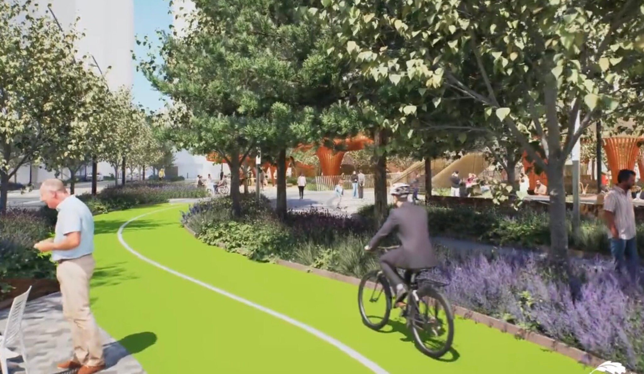
To refresh, the Green Loop was conceived in 2014 as a six-mile “linear park” around the central city. The idea is a series of low-stress walking and rolling paths connected by excellent public spaces. It’ll be sort of like a neighborhood greenway for the central city. Or, in the words of PBOT, a facility that will, “improve health outcomes, support business districts, expand inclusive access to regional destinations, and support the growth of Portland’s Central City.”
So, what has recently changed to spur all this activity?
When the Central City 2035 Plan was adopted by Portland City Council in 2018, one of the recommendations in the plan was to develop the Green Loop Concept Plan. In 2023, the Portland Bureau of Transportation won a state grant from the Transportation and Growth Management program to do that work. They finally kicked off the process this past spring.
According to PBOT, since 2018 there’s been a lot of visioning for the design and construction of individual blocks of the Green Loop. This new plan will refine the route, bring the design to a more granular level of detail, and nail down a phased implementation strategy.
In other words, PBOT and other bureau partners (Bureau of Planning and Sustainability, Portland Parks, Prosper Portland, and others) will look to mold what is now a relatively vague concept into something more tangible — something that could actually be built once funding and other opportunities present themselves. To do that, PBOT needs to understand what the public wants and needs out of the project. That’s where the survey comes in.
“We’re not building anything yet, but your input will directly shape how and where it happens,” reads one of the survey pages. Survey takers are asked to prioritize Green Loop objectives, rank design principles, share how they’re likely to use the facility, and more. The survey shows images of the Indianapolis Cultural Trail and the Miami Underline as comparable examples.
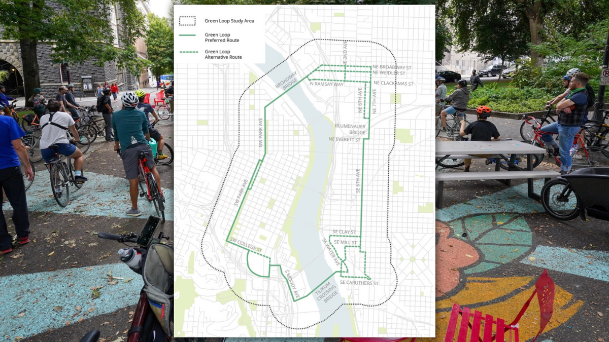
The 15-member Community Sounding Board (CSB) is expected to meet three times between now and winter 2026. Their job will be to provide feedback to city staff about the alignment and other elements of the plan. A presentation prepared by PBOT for tonight’s first CSB meeting lays out the existing conditions of the route alignment and the community and land use planning context. Ultimately, the CSB will make recommendations for designs and implementation strategies.
To learn more, check out the new website, take the survey, and consider attending the Sounding Board meeting tonight from 3:00 to 5:00 pm.


Thanks for reading.
BikePortland has served this community with independent community journalism since 2005. We rely on subscriptions from readers like you to survive. Your financial support is vital in keeping this valuable resource alive and well.
Please subscribe today to strengthen and expand our work.
Filled this out yesterday and I really emphasized how important the bridges are especially the one in the OMSI section. Their alternative to a bridge is to cross the tracks at grade level which is why I don’t ride that section currently. It’s not worth the hassle or risk. They’ve been promising that OMSI bridge since the Tillikum was being planned but keep cutting it to save money.
I’m also interested in what the other bridge looks like connecting Clackamas St to Ramsay Way over I5. That’s the first I’ve ever seen a bridge proposed for there. It would be quite large and have to go through a parking lot. I’m guessing that’ll put it on the fast track to cut.
I think the Ramsay Way bridge over I5 is part of the I5 Rose Quarter project (or was in some iterations), which also means that its on the fast track to being cut. I strongly prefer the Broadway/Weidler alignment, mostly because the roads are so wide and not busy enough to justify the width.
I generally prefer railroad grade crossings to the bridges we have already, since it’s usually flatter and faster to just cross at grade rather than lug a bike up a likely staircase (or a steep ramp). The OMSI area does have some elevation change which will make the north landing easy and the south landing more difficult to comfortably connect. Given that we probably won’t do a grade crossing solution which puts the tracks in a trench or on a viaduct, and the probably space constraints relating to clearance under the MLK/Grand viaducts and over the UPRR tracks, it seems like the bridge would be a stupid spiral ramp or staircase situation. I never take the Bob Stacey crossing over the grade crossing at 11th/12th unless a train is parked, and feel like the inevitable half-measure that a bridge here would present would prefer just a safer crossing at 8th (or Clay, but the Clay route has a bad crossing of MLK/Grand)
The fact that there is a ranked choice option which includes “clearly separated space for bikes and scooters” but not “wide bike paths” or something to that effect tells me a lot about how the City is going about this. It feels like bikes are just another burden to accommodate, rather than a central focus.
Ding ding ding we have a winner! Bikes are not the central focus of this city’s transportations woes.
That didn’t concern me. I think that, for a general audience at least, the difference between “clearly separated space for bikes and scooters” and “wide bike paths” is a little too nuanced.
I have a bad feeling we will be reading a similar article in another 11 years (I hope I’m wrong)
This is very concerning! It appears that City staff are so enamored with their concept that they are pushing it along without any acknowledgment of the fatal flaws of the concept. I like and support the concept of a loop around the Central City. Getting a green corridor through CEID that can function as a park an transportation route for people not in cars is a critical. Recommitting to the South and North Park blocks as places for people and not places to park is long overdue. Unfortunately, the loop does not work. Perhaps they should focus on creating a “ladder” instead of a loop- establish really good n/s routes on the east and west sides of the river, then strengthen every e/w connection to it. The fatal flaws that I perceive are:
I am excited to see the City move forward with bold thinking and commitment to green infrastructure. However, It does not do the project any favors to remain in denial about the fatal flaws of the concept. I hope someone in the City can show some leadership and either propose some functional, planning-level solutions or revise the concept to something that could function as promised.
I see your points on the Broadway. The counts on the Bway are antiquated, but it’s fairly safe to assume they haven’t increased significantly since the last count. I would not be surprised if separated facilities went in that we’d see a fairly steady increase in bike traffic across the bridge, since the current baseline on NE Broadway/Weidler is akin to riding on a highway. But I’m not entirely sure that would necessitate expanding the bike lane width (e.g., via cantilevers). I’m not sure if the Broadway would be a good candidate for cantilevers like the city did on the Hawthorne. The issues are with the lack of adequate separated space on the landings, not necessarily the bridge itself.
I agree that the landings (and signalizations) are real weak spots, but I disagree about that the bike lane width is adequate. If there were no peds allowed, I think the current sidewalks could support a lot more bikes, but they are very pinched currently for mixed-use. This morning on my ride in there was a couple walking east as I rode west. We saw each other and moved in a single file position. I slowed down and moved close to railing. Even with all that cooperation and visibility, it was a close pass- one of the peds had a parasol they had lift and angle out of the way. Overtaking peds is difficult because they are often side-by-side and it can be hard to heard when competing with car/street car noise. Currently, this is not a big deal, but there are almost no pedestrians now. The plans should be considering a huge amount of development (Post office, Broadway corridor, plus WNBA) and they should be planning for the greenloop to be a huge success and attract lots of joggers, walkers, families, recreational cyclists, rollerskaters, all added toa mix of commuters and people using e-bikes and other small motorized things. I just cannot imagine that mix working remotely well on those existing sidewalks. They certainly would not deliver the promise of a linear park or “low stress walking and rolling path”. Altering the bridge decks is not a trivial project, but ignoring the reality of the condition when the project is in the planning stage is negligent. This may need to be implemented toward the end of the project, but if it is not represented and considered, we will not be prepared when we need to be.
I know the Broadway is a rare type of bridge (i.e., bascule), which might make it a complicated endeavor, and that next year the county will replace pieces of it. A civil engineer would know more about the cost/feasibility of extending the path via cantilevers. Then there’s the whole <50 year imminent subduction quake, which will likely render these old bridges useless.
Judging by the pace PBOT has built out the separated network in the past, I’d guess it’ll be a long time before they tackle NE Broadway and Williams/Vancouver. I agree the latent demand for that is enormous (and will only grow from those developments you noted), and we’ve seen snapshots of it in the past from Jonathan’s Summer photo shoots. But that bike traffic is just not sustainable without consistently separated space, which PBOT is reticent to do in anything other than enormously expensive capital projects. I personally hope you’re right and the bridge will fill up.
My understanding is that is project would include improvements to the routes shown in the map. IIUC, it’s not simply putting up signs that define the route and calling the job done.
Is this the natural choice? You probably have to remove the existing deck entirely and start over to get additional width, and that assumes the piers can handle the additional dead load (I’m assuming live load is effectively unchanged by foot and bike traffic).
In any case, take the viaduct offline for any amount of time feels like a non-starter for a project like this one.
I think the route is the natural choice. I believe there would be a myriad of ways to achieve that without removing the deck, but I agree with you that this would be big project. Also, routing a MUP across MLK and Grand in this location would be logistically challenging. However, at the planning stage, I maintain that it is worth it and preferred over spending time and resources on a half measure that will never function well. If it simply not feasible and never will be feasible, then refine the concept- no more green loop. Call it a ladder or twin linear parks or whatever it is that is achievable. I think the project is pretending they are going to be bale to make a loop, but what they are showing is falling short. I think they either need to be more visionary or more realistic because what they are showing is not good.
You’re right, it’s a tough nut. There is a study (pg 8) to examine at-grade crossings in the CEID along the UP tracks. The recent fatality at the 8th ave crossing shed’s some light on how sketchy that area can get. Any solution should look at the 11/12th, 8th, MLK/Grand and streetcar viaducts holistically. I don’t see an easy/cheap solution.
While neither easy nor cheap, a friend told me about an idea to put a bridge across the tracks at SE 7th, where the north embankment is already pretty high, and have it land in the vacant lot opposite.
Perhaps the green loop can add some impetus to this idea.
I’m not sure about this link, but it’s from the UP site so maybe it’s legit. It shows 23′ 4″ min on vertical clearance and 9′ for horizontal clearance. A ped bridge might be possible, but that’s civil engineer territory.
The other idea being thrown around is to get the freight industry involved and go big or go home. A viaduct would solve the x-ing problems, but would be enormously expensive.
I don’t think there would be any political support for another pedestrian-only bridge. I think if it happens, a bridge would need to accommodate the vehicles currently blocked at 8th, 11th, and 12th, which means buses and trucks.
I’m not sure what you mean by “go big or go home” — where is UPRR going to go? What would “going big” entail?
Right, that’s why the freight industry might be the best course forward since there’s a shared interest. One option would include a viaduct replacing the current UP and MAX ROW with underpasses for 8th and 11th/12th. I’m not necessarily advocating for this, but it would limit at grade crossings a lot more.
Here’s a bportland story on the study linked above.
Where would you put such a viaduct, assuming we had the money for it? You’d need a different ROW because you’re not going to take UPRR or Max offline for years while you build it.
I’m not sure about much in this world, but I am pretty confident UPRR is not going to pay for such a project if it could even be built.
There probably is not an easy/cheap solution, but there is a need for a better connection. That is why I think it needs to show up in these planning documents. It takes a a long time, a lot of coordination and advocacy, and some sort of catalyst for these projects to happen. If the need is not well documented and long-identified, the project won’t happen. This connection, or some sort of pedestrian connection, should have been included when the streetcar viaduct was built, but the need hadn’t been identified. If the City doesn’t include these projects now, they be considered and incorporated as part of adjacent and related plans and pretty soon too much stuff has been built with accommodating these planned future changes and building them becomes even harder. Knowing that it will be difficult and expensive, it is still necessary to plan now for future success. If the CIty really truly believe there is no possible future where these changes should be built, then it should go back to the drawing board and admit that this will not a Green Loop, it will be something else (could still be good and worthwhile)
We don’t really need the “early engagement survey,” nor do we need the community sounding board. Spend that money on bollards or planters and put diverters on 7th. Separate the space, and evaluate how the community feels re the changes vs the existing baseline. That’s how you substantively engage the community.
PBOT needs to stop showing pictures of concepts and simply show with interim designs. Asking people if they want to bike on wide bike paths is like asking people if they want to walk on sidewalks.
It’s nice to see the rich get richer in such lovely accommodations. “Like a greenway”? I live on a Greenway in East Portland and I can tell you it’s not low stress when some jackass doesn’t give you any space on a shared surface. But I am excited to see the inner city get more nice things.
Extraordinarily expensive and luxurious linear parks for the bourgeoisie and deadly streets with no sidewalks for the working class on the periphery.
I wonder how many miles of safe routes to school infrastructure this boondoggle could build.
Sorry, it is just the economic reality that annexing the areas east of 205 (probably even 82nd ave), in hindsight, was an awful idea. Should have left these places as their own unincorporated areas or small cities.
I’m glad they’re moving forward on this, but I’ve got some reservations about the route. I understand that in the SE corner, they already rejected a pedestrian bridge from SE 6th and Division to the Rail Heritage Center, crossing both Division and the train tracks. That seems to me to be the best possible route — it’s direct, it’s entirely on publicly-owned land, it completely avoids pedestrian crossings at MLK and Grand, and it creates a meaningful pedestrian/bicycle bypass when freight trains jam up the area. None of the other proposed routes can do all of those things.
I also think the NE quadrant should just run through Rose Quarter from the Broadway Bridge to Rose Quarter Transit Center, and then close down Holladay from NE 1st to NE 6th. Fast and relatively cheap, with no need to wait for an ODOT viaduct that might or might not happen.
For the most part, though, I like where the planning is going.
Can you elaborate on why this option was rejected? I had not thought of this before, but it seems great for all the reasons you state. It would be great to have a nice, obvious route from the E end of the Tillikum crossing into SE.
I attended the Sounding Board meeting on Zoom, and they flashed a slide t one point that showed some routes that had been considered for that segment. I got only a glimpse of it, but (from memory) it looked like there may have been problems finding space for a sufficient ramp at the east end.
I’d like more information myself, because it seemed to me like an ideal route.
Thanks!
That route would work well, can you share any more background on who/why it was rejected?
11 years to just talk about it more?
what is the alternative? That is how planning works. Talk about it, build consensus, represent it so that future projects and planning can accommodate it.