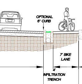
concept under consideration for SW Multnomah Blvd.
The City of Portland Bureau of Transportation (PBOT) and the Bureau of Environmental Services (BES) are teaming up on a project to add sidewalks, stormwater management and bikeways to SW Multnomah Blvd between SW 21st and 31st Avenue. This project is just the first phase of a plan to re-design Multnomah Blvd from SW Barbur all the way through Multnomah Village.
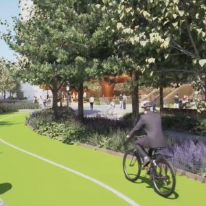
At an open house next week (2/17), the City will seek input on three designs — including a new concept that would separate the bike lane from the motor vehicle lane via a 4-foot wide “infiltration trench” (see graphic above). This design is the latest collaboration between PBOT and BES to combine stormwater management techniques with better bikeways. Some funding for this project is a result of Mayor Adams’ mandate to integrate bikeway improvements into sewer and stormwater projects.
In advance of the open house, I asked PBOT project manager Rich Newlands to share the three bikeway design options that are currently on the table.
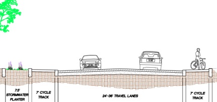
One concept under consideration is 7-foot cycle tracks on each side of the street that are raised above the roadway via a curb and separated from a 12-foot sidewalk (not shown in detail below) by a bioswale:
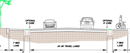
And here’s the new concept that would use an “infiltration trench” as a buffer between the motor vehicle lanes and the bicycle lanes:
A third design is a hybrid of the two:
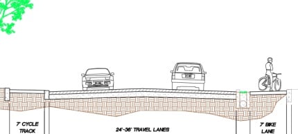
All the designs under consideration include new, 12-foot sidewalks on the north side of the street (download PDFs of the graphics above for full cross-sections).
The City of Portland is hosting an open house on this project on Thursday, February 17th from 6:30 – 8:30 pm at the Multnomah Center auditorium (7688 SW Capitol Highway).
In case you haven’t been paying attention, there’s been a lot of news coming from SW Portland lately and this project is a perfect opportunity to get involved.




Thanks for reading.
BikePortland has served this community with independent community journalism since 2005. We rely on subscriptions from readers like you to survive. Your financial support is vital in keeping this valuable resource alive and well.
Please subscribe today to strengthen and expand our work.
Amazing! Maybe SW Portland can “leapfrog” the eastside by going straight to cycle tracks! Good job PBOT!
MAC, 6:30 next Thursday – I’ll be there (then, a quick totter across the street for a pint and a slice).
At first glance, option 1 looks best. The trouble with the infiltration trenches is that they give a rider nowhere to bail out if needed without having to hop a trench. If I can’t negotiate the trackway, I’d rather make a controlled transition to the vehicular lane than an uncontrolled high-side into it because my bike decided to stay in the trench and let me go ballistic.
Sidewalks!?!?! What a novel idea!!!
These aren’t sidewalks.
While I applaud the City for providing protected bikeways, not providing sidewalk on the south side of the roadway is not acceptable. A “future sidewalk” promise is not good enough. Pedestrians will use the bikeway as a defacto sidewalk- creating conflicts. More design work is needs to be done to provide both.
I think this will be true. There is already a problem with joggers running against traffic and frequently insisting on jogging side-by-side, even when a cyclist is trying to pass. I regularly ride on this stretch of road and have to dodge pedestrians who have no where else to go.
Aw heck yeah.
Yes! This section of road needs this kind of plan. It is very heavily traveled by cars and the separation would be most welcome.
I also agree that the sidewalks on both sides need to happen. As Don noted, pedestrians are noted for taking whatever path is easiest and cycle lanes definitely fit that bill. Maybe 6′ sidewalks on each side instead of one 12′? Just a thought.
The last concern is where is the land for all this coming from? Maybe I’m wrong and there’s plenty of space already, but it sounds like eminent domain which will not make some property owners happy at all.
Whichever plan wins, I hope it gets built.
i wodered that as well, about where all the space is going to come from – looks like there’s 75′ or so of right-of-way, which is enough for just about anything your heart might desire.
Curb option is a bad idea. It becomes a hazard to cyclists when passing or avoiding obstacles. What happens if a cyclist hits the curb? They’re thrown out into the traffic lane. Also, it complicates street sweeping making for a messy bike lane. If there are trees lining the street it could become a major maintenance and safety issue.
The infiltration trench is another bad idea. When they are covered with permeable concrete they will drain fine, until they get plugged with silt and debris. PDOT better be prepared to vacuum them out on a regular basis as recommended by the concrete industry. When these are installed this is never done and they fail.
At the open house, would someone please say the motor vehicle travel lanes are way too wide? If the outside lane could be reduced to 7 feet, there wouldn’t be a need for separation.
The minimum permitted is 10 feet for a residential street. Something like this would need at least 11, if not 12 foot wide lanes. Most big rigs (including buses) find a 10 foot lane to be a very tight squeeze to start with.
Just in time to save a life! Wait…
Better late than never I guess.
Looks Cool!!
I support the 6″ curb and can we substitute “optional” with mandatory? It is a safety barrier not a hazard to cyclists, that will prevent cars from crashing into a flow of peaceful bike space.
Until you want to change lanes to make a left, or merge into the lane after making a left.
That 6″ curb mighta kept that silver Dodge Durango from grazing the hair on my left arm tonight, but Paul makes an important point. You might not want it there when you’re tooling down the road and have to take the lane to circumvent that real estate sign, broken headlight, pulled over police car, etc.
Just be a pal and throw the real estate sign and the headlight in the garbage where it belongs.
one dangerous thing about riding on the sidewalk is having cars turn into and out of parking lots in front of you. this separated-with-a-curb-raised-from-the-street-cycletrack looks suspiciously like a sidewalk to me, where i am often yelled at to be relegated to. i don’t really ride in this part of town though, so i guess cheer it all you like. we’ll have to rename the “copenhagen left” to the “multnomah left” once this thing is cast in concrete.
Correct about the cars hitting bikes riding from the sidewalk out into the street. There will be accidents because of this faulty design.
I think the new design, with the trench, should be tested somewhere before it is tossed out completely as an inadequate form of practice. There may very well be places where cycle track wont fit but some kind of protection form cars invading is necessary. With all the rain Portland has, the trench does seem…. interesting shall we say.
Anyway, bravo for considering cycle tracks Portland, that’s the best way you’ll reach your hoped 20% trips by bike
It has been tested. Though with an LAUSD education, I’d hazard to guess your globe didn’t have “The Netherlands” on it.
What’s with the unnecessary insult? I’m from Malmo Sweden which is minutes away from CPH and Malmo has plenty good infrastructure soo…. I likely have seen better bike accommodations than you. In the Netherlands I have not seen the the trench type facility used, please do share.
Will the curb on the outside of the track cause bike accidents like the girl riding at OMSI experianced a few days ago?
maybe instead of having a curb seperate the track from the road they could just do turtle bumps instead. this would allow streat cleaners to clean the track as well as the road
The right of way on SW Multnomah is very wide. It was an old Oregon Electric Railroad ROW, which is also why it’s relatively level. The ROW width from Barbur west to 25th is 100 feet. From 25th to 31st, it’s 87 feet. West of 31st, it’s 100 feet again.
So, I’m wondering why the cross-sections indicate “Street Section varies from 58 to 78 feet”, while not showing that the “Right of Way” is 87 feet, and in parts 100 feet.
Sidewalks (mostly 12 foot or 12 foot including planting strip) already exist on the north side from (what would be) 29th, to 31st. Even if there’s only enough budget for sidewalk on one side, from 29th to 31st do the south sidewalk, and from 29th east complete the north sidewalk. But I agree with other posters, lets do both sidewalks now.
In 87 feet, there’s plenty of room for travel lanes and parking (two lanes at 12 feet and two parking lanes at 8 feet), two 8 foot cycle tracks, two 12 foot pedestrian corridors (4 foot tree wells or planter and 8 foot sidewalks) and 7 feet left over for swales, trenches, etc. Perhaps the swales could be combined with planting strips, as long as they allow for the very large trees (80 feet high x 80 feet wide) that a 100 foot wide ROW demands for proper shade coverage. (Trees planted within swales are limited to certain flooding-tolerant species, so they may need to be outside the swales) I hope there aren’t plans for any left turn lanes within this (maybe at 31st?) which would mean deducting 14 feet in their vicinity.
I wonder if the south side sidewalk was not considered because there’s still a ditch on that side which would still be used for stormwater runoff, complicating sidewalk construction. Perhaps we can find out before the 17th.
Wouldn’t it be nice to have trees shading the entire 100 foot right of way here? Unfortunately, the plans shown have trees at 8 feet from the ROW edge. With a symmetrical tree canopy, that’s a 16 foot wide canopy. Two rows, and you’ll still have 68 feet between the trees that’s unshaded.
So here’s an opportunity, but also an issue. If you plant trees 25 feet from the ROW edge, and they have 50 foot canopies, you’d have 100 percent coverage. However, that’d mean trees next to the curb, with the cycle track and the sidewalk both behind the trees. Fine for the sidewalk, but potentially problematic for cyclists at side streets and driveways. (Although such large trees would have their trunks at least 50 feet apart, and be pruned up at least 16 feet)
Could this be addressed by putting the cycle track near the road in the sections with side streets and driveways (mostly the north side), and behind the trees on the south side (except at 31st, 25th, and 22nd?)? I think it’s worth seeing if there are parts of the street where this could work.
Or just put the trees on a center median. Works for Tulsa.
What is the difference between bike lane and cycle track? They are both physically seperated from auto lane and both 7′ wide, so what designates one as a cycle track?
Bicycle lanes are not physically seperated from traffic, and bicycle lanes are typically 4′ if adjacent to another bicycle lane in the same direction (such as the slow lane westbound on Hawthorne Bridge’s east approach) or 6′ if adjacent to general traffic lanes in the same direction (such as most bike lanes) or adjacent to any lane going the opposite direction (such as the lanes on the Springwater Corridor).
That said, 7′ is an exceedingly odd choice given the usage…perhaps two 4′ bicycle lanes on an 8′ track would be better (since the physical separation from the rest of traffic makes the track a separate roadway, 4′ lane applications would be suitable here)
Why was my post deleted? Is it your policy to ban everybody who disagrees with your pet projects now?
Uggh. I forgot that embedded flickr links don’t work in the main comment section. Here’s a regular html link: http://www.flickr.com/photos/49622638@N00/5279198763/
This looks like a seriously stupid idea. Unlike Broadway by PSU, there are side streets and driveways here.
Sure, in cross section, you say, it looks real nice because the cars have their space, and the bikes have their space, and everyone is safe. The cars can’t hit the bikes because there’s a curb.
But the curbs can’t be continuous. Why? Cars make turns into side streets and driveways. So do bicyclists. And it is difficult enough now to keep cars from right hooking bicycles in the bike lane, or intruding into the bike lane from side streets. Don’t believe me? I’ve got video of right hooks here:
http://www.youtube.com/watch?v=wzvchwIgHe4
http://www.youtube.com/watch?v=PlasOg-v2w8
And cars pushing into the bike lane here:
http://www.youtube.com/watch?v=dMAgmVefvus
http://www.youtube.com/watch?v=opq_F4DqDf8
The cycle track will be more separated from the general purpose lane than the equivalent bicycle lane. I think it’s less likely that car drivers turning to/from side streets and driveways will remember that they have to stop BOTH for bicyclists on the cycle track and motor vehicles in the general purpose lane.
And do you think that a curb is going to protect you from a car going the speed cars go on Mulnomah Blvd? I don’t think so. Take a look at this picture, which shows the mangled fence on Barbur. It’s since been repaired. http://www.flickr.com/photos/49622638@N00/5279198763/ (I tried to post this as a reply, above, to another comment. I don’t think it came out right. So sorry if you are seeing this twice.) If a motor vehicle going however fast on Barbur can jump the curb and cause that kind of damage, then the curb isn’t providing that much protection and isn’t worth the trouble.
Oh, you say, it might not be a curb, it might be a drainage feature instead. We already got something like this, and it’s a pretty poor excuse for a bicycle facility: the Garden Home Road bike path. Starting from the proposed cycle track, it’s only a few miles to the west: follow Mutlnomah until it runs into Garden Home Road, then stay on Garden Home west of Oleson. Here’s a video of what it’s like to ride that:
http://www.youtube.com/watch?v=fLuhpDlWs_s
How about instead of spending extra money making fancy cycle tracks, realize that anyone who is riding that stretch of Multnomah already is probably dealing with Barbur to the east and Multnomah to the west. Both already just have striped bicycle lanes. If the bicyclists that can reach this proposed cycle track can deal with that existing infrastructure, then striped lanes is what we need along this section of Multnomah.
I’m not saying don’t spend the money. How about instead spending it where it will do some good, and address an issue that bicyclists complain about in this area: the narrow bridges on Barbur. No, of course a cycle track does not cost nearly as much as a bridge. But, enough cycle tracks and enough other silly look-good-but-useless projects DO cost as much as a bridge.
And, yes, I do ride in this area. Multnomah was my alternate route before Portland’s Bureau of Environmental Services decided they had to tear up the street to install a new sewer, for a second time in just a few years.
Waste of time and money. A whole half mile (1.5 to 2.5 minutes of bike travel) of the least trafficked section of Multnomah Blvd being built up -for what? After that half mile, you’re back on a standard bike lane filled with road debris, potholes, and crossed by all manner of streets and driveways.
I commute through that section routinely. I also agree that the streets feeding into Multnomah and being turned on to by car traffic will create significant hazards for those who think they are “safe” on the fancy cycletrack. Down by Multnomah Village and the section between SW 45th and Garden Home could use upgrades due to higher speeds and greater auto traffic volumes. This proposed section? Not so much.
Yet another “Throw Bikers a Bone” project from PBOT and Adams.
The whole street in this stretch is being torn up for a sewer pipe repair. The question is, what to put back? Yes, it’s not the entirety of Multnomah. But why not agree on a design and get this section done the best possible, so that with future work, the rest can be also upgraded. Waiting for any improvements until an entire street can be done at once reduces the chance of improvements ever being done.
Sometimes short sections are the best way to leverage funding from other projects.
I don’t think that we agree that a cycle track is a best possible design.
I went to the meeting tonight. I gave them an earful. I also got the project manager’s email address (which I spell out here in an attempt to foil address scanning bots:) rich.newlands at pdxtrans dot org
It should be pointed out that trying to defeat spambots usually makes it harder on legitimate users without doing anything to impede spammers: If a human can figure it out, a spammer can write a script to do the same. Guess whose email still gets through without much effort?
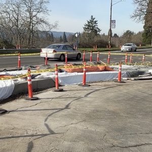
So… Three years later, and this is *FINALLY* happening. Can’t quite tell what the final arrangement will be, but on the North side, it is a rampcurb-separated bikeway part of the way (Barbur to 29th/30th,) and it LOOKS like it will be “parking separation” from 30th out. (i.e. they have the same light-concrete-with-rampcurb next to the sidewalk, which used to be parking, with plenty of room to move the parking out toward where the old bike lane used to be.)
The South side is obviously getting major work done, with a full-on hard curb being built so far out, that there won’t be room for a bike lane on-level with road – so I presume they’re doing either a combo bikeway/sidewalk, or something similar. (Unless they do some serious extension Southward, I don’t see room for separate bikeway and sidewalk.)
I don’t like the all-new paved parking spots! Those should be for peds/bike/trees.