(Photos © J. Maus/BikePortland)
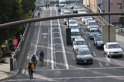
Multnomah County unveiled new and expanded bike lane on the Hawthorne Bridge viaduct over the weekend. Working in a partnership with the City of Portland, the County (who manages the bridge) gave permission to PBOT crews to re-stripe two sections of eastbound SE Hawthorne Blvd between SE Grand and the Willamette River.
According to to PBOT, the new striping was done to improve conditions for both bicycling and walking on the popular thoroughfare.
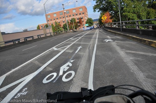
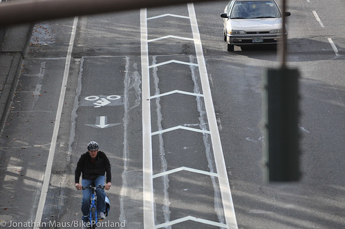
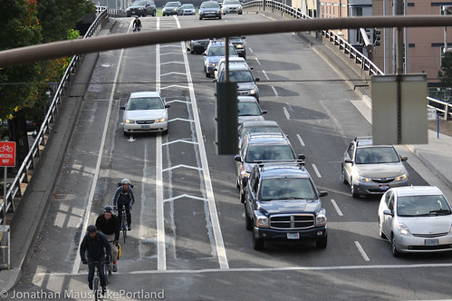
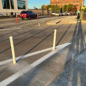
The first changes are seen east of the TriMet bus stop about half way between the end of the bridge path and the intersection with SE Grand Ave. Instead of a wide buffer zone and a standard-width bike lane, PBOT and the County decided to create two bike lanes side-by-side. PBOT spokeswoman Diane Dulken said they decided to increase the bicycling space because people were passing each other in the buffer zone…
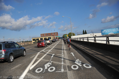
Further east PBOT has also added new striping to help with the traffic interactions where an off-ramp heads down to SE Martin Luther King Jr. Blvd. In addition to the changes in the bike lane, PBOT has also added several new features for people walking eastbound on the viaduct. There’s a new zebra crossing across the off-ramp and then an entire lane for walking as Hawthorne approaches SE Grand…
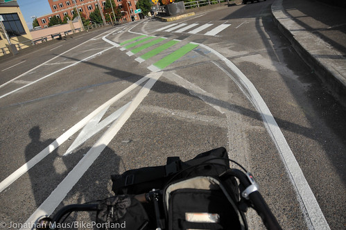
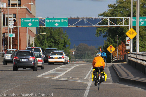
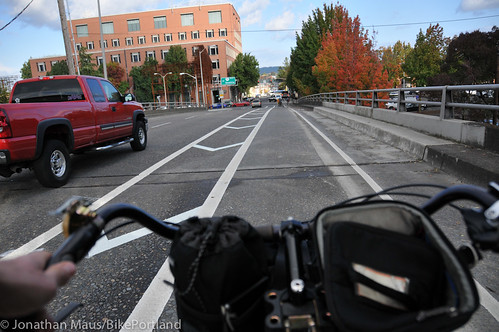
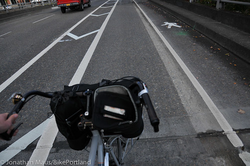
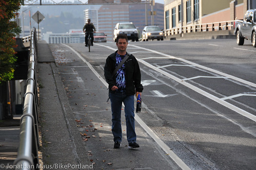
On the section just before the SE Grand intersection, PBOT has re-configured the traffic lanes so that instead of a bike-only lane and three standard lanes, there is now only two standard lanes, a much wider (and buffered) bike-only lane, and a walking lane. People walking eastbound in this location were previously forced up onto a very narrow sidewalk next to a guardrail. Sources at PBOT say a full sidewalk will eventually be constructed.
Here’s how the cross-section looked before…
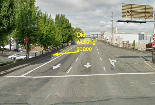
And here’s how it looks now:
As I observed this new configuration, I wondered about a few things. Why not add some plastic bollards, jersey barriers, or other forms of physical separation in the buffer zone? Clearly — as seen below — some people won’t heed just paint…
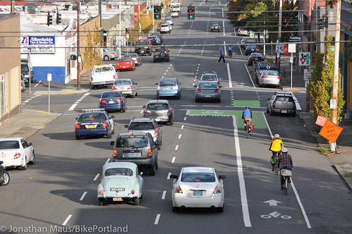
And when will PBOT take the painfully obvious next step of continuing this lane alignment east of Grand? Here’s how it looks now…
PBOT’s Dulken said these recent changes are simply part of the agency’s efforts to keep up with “the ever increasing bicycle traffic.” “As we all know,” she said, “the Hawthorne Bridge is a bicycle commuter through-way so we’re accommodating that. It’s very important for people walking too, so that [walking] section is a big improvement.”
So far, our readers agree. Reaction on Twitter has been very positive. What do you think of the changes?
UPDATE 10/11 at 9:00 AM: Several commenters have asked why the plastic bollards were removed. The County says they were taken down during the re-striping and they are being re-installed today.



Thanks for reading.
BikePortland has served this community with independent community journalism since 2005. We rely on subscriptions from readers like you to survive. Your financial support is vital in keeping this valuable resource alive and well.
Please subscribe today to strengthen and expand our work.
This is super awesome! The walking area is long overdue and much appreciated as is the buffer for bikes.
It’s pretty embarassing for the City just how bad the connections to/from the Hawthorne are. At this point, I’d say they’re as stressful as the bridge itself or more so.
I wondered what they were up to there…
Did they do anything to make the crossing of the southbound MLK exit any safer?
Also, I wish they would find another way besides grinding to remove the old paint/thermoplastic markings, the grinding leaves behind some fairly rough pavement and a low area for water to pond in during the rainy months.
I know. I feel like they should just use gray/black paint. I know it wouldn’t be perfect match, but at least it would be smoother.
I’ve heard that works in drier climates but does not last here. But there are examples of the grinding working well – it’s when they get too deep that they create a dangerous condition. Like they have in many locations around town.
The walking space is well deserved, but something tells me that added bandwidth on the viaduct isn’t going to improve afternoon rush hour on the bridge itself.
Never mind the yahoos that roam the bridge at night. After 9, it’s always a gauntlet.
I think the new light rail bridge opening in a few years will take a lot of pressure off the Hawthorne. Until then though… why do cars get four lanes, and bikes none on the bridge itself, when the mode split is clearly getting closer and closer to 50/50…
Because of the bridge surface. You do NOT want to be riding a bicycle on that metal grating, especially when it’s wet.
I’ve ridden on the grated surface a few times and taken the lane… it’s not bad… but I wouldn’t want to do it when it’s wet…
It’s really not that bad, wet or dry. It’s a little extra vibration, that’s all.
Try turning or using your brakes on wet metal and get back to me if you survive.
It’s just like riding on black ice: don’t slow down, speed up or change directions in any way and it’s not a problem. Forget about maneuvers to avoid this or that, you need to maintain a perfectly balanced line with your wheel track or they’ll pop out from under you like a wet bar of soap.
I don’t think it’s too bad to ride on, but I could not IMAGINE the effect on my face if I fell!
Now that the cones are gone my guess is that we’ll have more cars driving in the bike lanes. Is there any reason why they were removed?
This a great improvement, but if it’s mean to be permanent, why not add cement barriers and paint them up like they do in NYC? The space is wide enough for a street sweeper to fit.
http://www.thelmagazine.com/images/blogimages/2011/04/20/1303313652-flushingbb-03.jpg
pay attention to how many cyclists merge across into the left lane next time you ride the bridge during peak commuting hours.
It could be instructive watching how people on their bikes in the new bike lanes go about the preparation for making left turns from the Hawthorne bike lane.
Instead of transitioning directly from the bike lane across the buffer zone and into a main travel lane (turn signals used in advance as required.), I’m wondering if people will find it’s better to travel in the buffer zone for some distance while signaling, before transitioning into a main travel lane prior to the left turn on Grand they’re approaching.
Generally, the changes here…double bike lanes, pedestrian lane…look good, and probably will help people feel more at ease, as well as have them be safer as they walk and bike across the bridge viaduct. Especially if the reduction from three to two main lanes doesn’t dramatically constrict motor vehicle traffic flow, these changes may come to be seen as quite a success by people driving, as well as by people walking and biking.
the vast majority are doing that after Grand though. Very few cyclists are turning left onto Grand.
I do this commute every day. While it’s true the majority of left-turning people on bikes (including myself) cross SE Grand in the bike lane and transition across 3 lanes of one-way traffic to make a left somewhere, there are usually 2 – 3 and sometimes even more people who cross lanes on the bridge in preparation for turning on SE 6th, 7th, or 8th. It’s very difficult to make it across for those turns if you only start after Grand.
The Coppenhagen Left is always an option.
it’s also one that many people who bike choose not to use.
The key is flexibility. I’ve used the Copenhagen left at 8th or 9th, I’ve crossed to the left lane prior to Grand, I’ve crossed to the left lane between Grand and 7th, and once in a while, I’ll take the left on 12th. It all depends on what the traffic looks like, what I’m riding and who I’m riding with.
Hawthorne being what’s turning out to be a fairly high volume route for people on bikes, I wonder if it’s realistic to expect considerable numbers of people to go through the awkward maneuver that a Copenhagen left turn can consist of. What that kind of turn infrastructure or procedure consists of seems to vary some according to the situation it’s used.
If someone would like to describe details of how they think the procedure for such a turn would be for east bound traffic approaching Grand, 6th, 7th, or 8th, that may help to understand how suitable or not, that procedure could be with this new viaduct road configuration of Hawthorne.
What’s considerable? I’m curious as to the percentages of people who are riding down Hawthorne to Ladd’s or turning right somewhere versus those who are trying to turn left after the bridge. I know the left turners aren’t miniscule, but in my experience they are a minority.
Left turner! I usually get to the far left lane just after the “crest” and before grand. And then hold the lane before turning left at twelfth (which would be the most awkward, time consuming, Copenhagen left situation). And then right on Madison, the first turn.
Seems to work great for me. Appreciate the new markings.
One angle no one has mentioned: how nice it can be to have two lanes of bike traffic on a long hill section. Makes passing slower rides a more comfortable experience for all.
Before answering that question, probably first should look into what a ‘Copenhagen left’ turn would be for the westbound on Hawthorne approaching Grand situation. I’ve just seen a few pictures of C-left turn infrastructure in Amsterdam, which basically made use of a crosswalk kind of affair to allow that kind of turn.
Did a brief web search, finding that apparently one street situation in Portland uses what’s described as a ‘pocket’ to provide people on bikes, after they’ve crossed the intersection on the street they’re traveling, a place to set up and wait for traffic to clear so they can proceed with the turn they want to make.
How much room on the street this type infrastructure would require…will there be enough space for more than one person there at a time…for it to work well, I think may be part of the answer to the question. Also, what things would make people feel obliged to make a C-left turn at this intersection.
As somebody who often does this, I still see no reason a physical barrier can’t help protect riders and walkers, especially now that there’s a ‘walking’ lane in the street where apparently cars are still going to try to drive.
I think the County has been game for this restriping for awhile now (reducing the eastbound approach from three motorized lanes to two), but it took awhile for the PBOT traffic folks to get comfortable with it. I’d be interested in knowing what it took to get over the hump politically and whether there are any lessons learned that are transferable to other restriping ideas around the city. Great to see regional partners working together to make good things happen, either way.
Really fantastic news. Nice to see Portland and Multnomah County making good things happen quickly.
Biking on Multnomah tonight, I realized the city needs to buy a narrower street sweeper for these cycle tracks. Perhaps as small as the one I saw in London years ago, which was about 8′ long and 4′ wide, but only about 3′ high, with the driver sitting at the back. It was very manuverable, too. They used it on the sidewalks as well as the street.
or we could save 50 grand and get rid of the pointless planters and bollards.
I disagree wholeheartedly with removal of the planters and bollards on the NE Multnomah cycle track. They are the ONLY thing preventing motorists from driving, turning, merging, parking (aka you name it) illegally in the bikelane. TRUST ME ON THIS. I live on the street.
i don’t have to “trust you” since i’ve ridden on perfectly functional buffered and enhanced bike lanes all over portland.
50K is peanuts in transportation land. PBoT says a new signalized intersection runs from 250-500K.
I love the ped improvements! I wonder how many pedestrians will use it though? It looks like a bike lane, honestly. I think better ground markings indicating it is a ped space would go a long way. I think a lot of bikes are going to be still in the ped lane for a while. After all, it still looks like a bike lane.
Straight up to Tabor please…..
This is a great improvement!
I still think the auto off-ramp to MLK is poorly designed. The current and former design communicates to drivers that people on bikes are crossing “their” lane when oriented perpendicular to the auto direction. If the bike/ped lanes simply went straight, rather than the funky kink, it communicates that autos are crossing a through-lane of traffic, rather than the other way around.
Downside of making the bike lane straight, may be that, since the angles of the road and the off-ramp aren’t right angles, people driving motor vehicles would themselves either have to be channeled into a funky lane kink as they access the off-ramp, or instead, they’d be obliged to transition into and travel longer in the bike lane as they approach the off-ramp. Kind of a right hook hell, but the kink attempts to make the intersection of the two modes of travel a little more of a right angle design.
I definitely agree. Right now it is unclear who has the right of way after crossing grand (continuing down Hawthorne). If you are riding in the bike lane and cross Grand, it leads you into a car lane, which I can see as a major trouble spot as cars start to merge into the same lane while they are crossing Grand. I see this leading to major frustrations on both sides.
I do not think highway-style ramps are appropriate in the city. They encourage speeding and decrease safety. If we closed the ramps, traffic would simply use the existing grid to get where they need to go. The ramps are sketchy where they start, but IMO they are even worse for pedestrians and cyclists at the bottom attempting to cross! If they were decommisioned, the entire block taken up by the ramps could be redeveloped. On the east side where there is no green space, these could make pretty cool parks! THe ramps could be rebuilt into a wide walk on the outside with terraces on the inside overlooking the central green space.
Actually, they’ve already closed the eastbound left turn off-ramps to SE Grand from both the Hawthorne and Morrison Bridges. But if you closed that southbound MLK ramp on the eastbound Hawthorne viaduct, you’d probably just move all the right turning maneuvers up a few blocks, to 7th or 11th.
What bothers me is that, as the bike lane and buffer get wider at that off-ramp, the turn radius for the exiting motorists gets larger as well, encouraging faster, rather than slower speeds.
The geometry is entirely about safety. The closer to right angle the two vehicles approach each other, the better peripheral vision can see conflicts. It’s one reason why the Dutch corners work so well.
I think the highway style ramps should immediatley be closed! Traffic could be normalized into the grid at either end. The bridge could be redevelopment opportunities on the west side, and cool openspace opportunities on the east side; there are no parks in the central eastside! Imagine the outside 10-12′ of the current ramp lane retained as sidewalk/mup, and the inside developed into a series of level terraces overlooking the central green space!
Yes. Down with kinky designs for these crossings. What needs to happen at locations like this is exactly what you describe: an earlier crossover zone where drivers must merge across the bike lane into a right-only lane. These kinked crossing designs only facilitate the bullying of cyclists and peds by drivers who cannot be bothered to yield for someone waiting to cross here. I’ve only ridden this bridge once, but looking at the old layout, I would have rather shared the bus lane until it ends, then ride in the buffer until I could merge into the main lane to cross that exit point. I don’t see why the bus lane could not be shared with bikes, which would eliminate some awkwardness of buses crossing (or not crossing–who knows?) the bike lane to make the bridge stop, then have the bike lane stripes take up (dashed) at the end of the bus lane and be at the left edge of where the bus lane was. From that point on drivers would need to look for an opening to merge across into an exit lane, which would be done just like any other lane change maneuver. There would be no question of right-of-way as first-come, first-served would apply, and it would be drivers needing to slow down and wait for an opening rather than cyclists coming to the “kink” and waiting to see which driver is going to yield (as is their legal duty) while watching many more whiz by without a thought.
I guess my arrangement would be too scary for many folks, which is why we end up with crossings like this which are even more scary for those who know. Of course, my clever plan does nothing for peds, who would still have to wait for some minimally aware driver to stop and let them cross at the kink.
amen 100%
Looks good.
Looks great! Thank you very much PBOT and Multnomah County for providing adequate space for all users 🙂
Let’s see more like it, yeah? 😉
Not good for those of us who need to turn left (north). I’ve always found it safer to use the buffer lane &merge into the left lane before the signal at Grand. Cars are not accomodating even if signaling etc to merging across 3 lanes to go north @ 6th or 7th. They’ll be less so now that the see bicycles have 2 lanes.
I’m a little torn on this. I also liked to get to the left lane between the exit to MLK and the light at Grand. Often there would be a big backup at the exit and two relatively open lanes to get across. Now that we’re down to two auto lanes, we’re less likely to see those gaps. On the other hand, more auto traffic (at least yesterday) means slower auto traffic and I was fairly easily able to get to the left lane between Grand and 7th.
They should allow busses in the new, wide lane. “Bus/Bike Only”. We need to improve public transit and cycling in the city, and they should use opportunities like this to improve bus speeds. This lane would allow busses to bypass backed up cars at the signal. They could even extend the bus-only lane all the way to 12th.
That’s an interesting idea Chris. I think I like it. Adding buses would also make the re-allocation of space an easier political lift I would think. But it would have to come with major training for bus operators (and other users too for that matter) and perhaps even new policies/laws about how to pass other road users and so on.
I for one would be willing to consider a bus/bike lane if it meant a quicker implementation of a dedicated, expanded, protected cycle path all the way from the bridge viaduct to 12th. (and then at that point, why not all the way up Hawthorne!).
Similar to the Boulevard Saint Germain in Paris FR – a combined 16 ft area bike + buses vs. old individual bike and bus lanes pre 2003.
These combo lanes also open up the opportunity for fire and ems vehicles to have quicker access through the city especially during peak period traffic jams. Some communities also allow taxis with passengers to use them too. These all help to build support for these new layouts and wider than 5 foot bike lane on important regional arterials.
Chris I,
I agree that we need to improve transit/bus service, but I disagree with creating bus/bike shared space. It happens in a few places and it works terribly IMO. Busses are way too big and have too many blind spots to mix well with bikes. Plus they spew massive clouds of exhaust!
This short section would purely be a queue jump. Yes, the bus could only travel as fast as the bikes in the lane, but if the car lanes are backed up (which they will be in the evening), the bus can pass on the right and jump ahead once the light turns green. East of Grand, busses and bikes are already sharing space. Busses have to merge into the bike lane to make stops. Creating a 14-16ft wide bus/bike lane between Grand and 12th wouldn’t really change anything, except for keeping cars out of the right lane and reducing right hooks.
Oh, thanks for clarifying. That seems much more acceptable, however, in my observations, when a bus is stopped in a space shared with bikes, the bikes get very close and try to maneuver around the stopped bus. When this happens, the people on bikes become very hard to see for a bus operator, and if a bus is taking off from a stop while surrounded by bikes, but leaves at an angle to try to “beat ” the adjacent traffic, that creates a super sketchy situation.
The buses wouldn’t be able to move faster than the bicycle traffic in the lane – it wouldn’t speed them up at all. And (as someone who does this commute every day) it would make me extremely nervous to share with buses. There is also very bad connectivity from the end of the double bike lane to the standard lanes which continue down the bridge ramp. On the ramp, the double bike lanes disappear in favor of one bike, one walking lane. There’s no way buses could safely or happily share with pedestrians in the same lane.
LOL, my concern was more “bikes wouldn’t be able to move faster than the bus traffic in the lane.”
Even better, they could make the right lane of SE Hawthorne from the viaduct all the way to 39th bike-bus-right turn only.
I don’t think TriMet will do it because that would imply that bikes and busses could share the downtown transit mall, too; which is something TriMet has resisted for a long time.
But shared bike-bus lanes do work in other places, like Paris, France.
they also work in san francisco and philly.
Good in concept, but when I’m on a bike I don’t like to be behind a bus and when I’m on a bus I don’t like to be behind a bike. Bikes and buses mix as well as bikes and cars mix, which is to say they don’t mix at all.
It needs bollards or other barriers. The lanes are already configured – adding the barrier is the easy part.
Much better – Actually good, however I continue to be anxious at the crossing of the ramp down to McGloughlin. My fear is that a cyclists will get creamed there by an impatient motorist.
riding east is still pretty nerve wracking with heavy traffic and right hook potentials at every intersection and at Burgerville and the liquor store.
I love it. Pedestrians definitely needed more room there, it was not ideal for peds or bikes trying to pass them with traffic on your left.
At some point I feel like the bike/ped crossing at the onramp to 99 is going to come to a boiling point though. I see huge lines of cars there, mostly patiently waiting for bikes to go by, which is awesome. But I know many of them are stewing. Don’t know what the answer is, but I’m surprised something bad hasn’t happened there yet. I’ve seen impatient drivers pass everyone on the right and blow through that crosswalk before. Maybe a fast cycle traffic light or something? Tie the light cycle to the light below the ramp at Clay perhaps. I don’t know what, but eventually something.
They COULD put in a car & bicycle traffic light. There are solutions.
hope it doesn’t take long to get the sidewalk put in, I’ll miss not having a curb to put my foot on while waiting at the light…
now there can be a race crit at the light to queue up position in the bike lane going in this direction, too. although, the uphill on the westbound ramp provides some natural separation. eastbound direction just has the pavement waves crossing all the lanes on Grand…. As was pointed out above, the only thing missing from the crit in the eastbound direction are buses.
“And when will PBOT take the painfully obvious next step of continuing this lane alignment east of Grand?” A few months ago, I saw some drawings with a big cycletrack and…wait for it…BUS ISLANDS. Not sure what the status of that is.
Bus islands? TriMet has already shot down this idea, I’m sure.
Why would they shoot it down? It reduces stopping time and bike/bus conflicts. Think of the streetcar stops in the South Waterfront.
More info on shared bike/bus lanes:
http://www.bikexprt.com/bikepol/facil/lanes/bikebus.htm
I’m delighted at the new lane configurations, but I wish they’d put the plastic bollards back. I really liked having them as a very obvious marking between the bike space and the car space. In the dark, in the rain, it’s very hard for drivers to see painted lane markers. Concrete planters would also be just fine with me. They can disappear after the exit crosses the bike/walk lanes – the bollards weren’t there before and they could easily interfere with left-merging traffic out of the bike lane.
It would be nice to see them build up the whole walking lane to have a standard curb. I was completely oblivious the first time I rode the new configuration – it just looked like a continuation of the double bike lane.
With this work … did the City or County grind or resurface the roadway section where the bike traffic crosses the northbound traffic lanes on Grand? All the wheel rutting makes it very dangerous / uncomfortable when biking across at even less than posted speed – the bike pitches up and down.
“PBOT spokeswoman Diane Dulken said they decided to increase the bicycling space because people were passing each other in the buffer zone…”
The best type of infrastructure caters to both year-round mashers and the more cautious.
Another example of this more inclusive approach is the design of the new Sellwood bridge. A grade-separated lane AND an in-grade lane:
http://www.sellwoodbridge.org/files/renderings/belvedere–bench-plan-view.jpg
I’m delighted to see a the use of the “bike passing lane” here on the eastbound viaduct.
If you look at Appendix D of the Portland Bicycle Master Plan for 2030, it lists two types of wide bike lane treatments — bicycle passing lanes, and buffered bike lanes.
http://www.portlandoregon.gov/transportation/article/334689
(pages “2 of 41” and “3 of 41”)
The city has put in a lot of buffered bike lanes since 2010, when this was published, but this is the first additional bike passing lane. Previously, the only bike passing lane in the city was on the uphill section of Madison getting on to the westbound viaduct.
Many of the places that have had buffered bike lanes are clearly better candidates for bicycle passing lanes, because of this high number of bicyclists, high discrepancy in preferred operating speeds between bicyclists, and uphill grades.
For instance, climbing the hill on Wheeler/Williams from the Rose Quarter there’s a buffered bike lane, but fast bicyclists use the buffer all the time to pass slower bicyclists. And they pass closer than is safe. Bicycles, especially on an upgrade, require 5′ of width in the roadway to ensure that if you wobble a bit you don’t collide with the curb or infringe on the lane to the left, and the hill there has only 7 or 8′ of total width — 6′ for the bike lane, 2′ for the buffer. And the passing behavior puts cyclists at an unnecessary safety risk.
The bike passing lane, with each lane a full 5′ in width, the width dictated by the AASHTO Bicycle Handbook and the Oregon Bicycle and Pedestrian Plan, and many other plans around the country, should be the engineering standard used in areas where there is a lot of demand for bicyclists to have space to overtake one another.
Thanks, PBOT, for giving us a piece of this infrastructure, hope to see more of it pop up around town, and around the country.
Ted Buehler
Got passed on the right here yesterday afternoon by a cyclsit flying through to pass all of us patientialy waiting to cross Grand. I guess he was using the ped lane. Others coming up in the buffer space on the left of the cycle lane. New painting may create a feel like the center lane on I-5: just camp out at 55 mph and watch as you get passed on both sides.
PBOT could build elevated bike routes to completely isolate riders from drivers, but riders still need to be competent. Just this morning, west bound at the Grand/Hawthorne stoplight I was lined up with the cycling rush our crowd and a guy in front of me was making out with his girlfriend/wife. The light changed, he couldn’t get his feet on the pedals and almost fell over. Jeeze get a room or save it for later.
Pay attention people