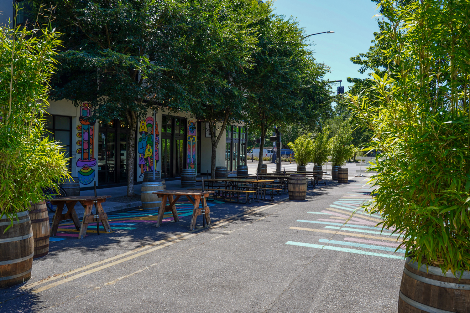
Maria Sipin joined me in the shed this week (Eva Frazier is out of town). Maria is a transportation planner and community organizer with a long and impressive resume as a volunteer and agency staffer. She’s currently the campaign manager for Portland City Council D4 (W/Sellwood) candidate Mitch Green, and in the past she’s been a planner at Oregon Department of Transportation, has worked at Safe Routes National Partnership, was on the Portland Clean Energy Fund Community Advisory Committee, and recently worked on the campaign to get participatory budgeting on the ballot in Portland.
Advertisement
Maria and her Lectric e-bike.
We talked about all sorts of stuff, from bike valets to a renters’ bill of rights to her electric bike, Bike Loud’s Bike Buddy program, and much more.
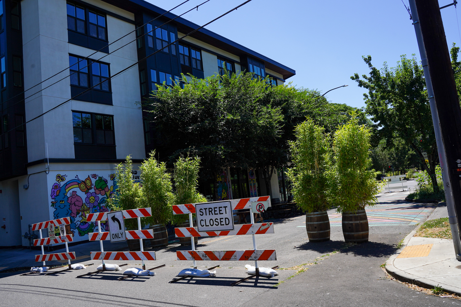
NE Broadway near 15th. We can do a whole lot better than this!
If all goes according to plan, by next summer a key segment of Northeast Broadway will finally receive a design update that includes protected bike lanes.
In the past week or so the Portland Bureau of Transportation (PBOT) has uploaded the website for the NE Broadway Main Street Pave & Paint Project. This site makes official what many Portlanders have dreamed about for years: turning inner Broadway from a car-dominated stroad into a more humane street where people can walk and bike — and drive! — with much less stress and crash risk.
The project was triggered by a need to install fresh pavement between NE 11th and 24th. And as PBOT prefers to do, they’ll seize the opportunity to update lane striping when given a blank canvas to work with. And with major bikeways already established on NE 7th and NE 26th, the project scope will go beyond the new paving boundaries to make connections to those existing routes.
Advertisement
(Source: PBOT)
The current cross-section on this section of NE Broadway has five lanes for car users and just one narrow, unprotected bike lane. The final design is far from final, but early concepts have all shown at least a seven-foot wide, curbside bike lane and three-foot buffer zone.
While the conventional wisdom is that there will be less space for drivers in the new design, nothing is certain until the paint dries (and even then we know PBOT can change their mind). And given the high-profile stature of Broadway as a major commercial corridor, we should expect healthy debates about the final cross-section.
On the PBOT website, they place “support a vibrant main street” and “make the streetscape work better for [the small business community]” atop a list of project goals. Other stated goals are to make the street safer, make it better for bicycle riders and walkers, and “develop a high-quality project with broad community support.”
Advertisement
One major thing to keep in mind that sets this project apart is how it ties directly into the I-5 Rose Quarter megaproject. PBOT received a $38 million federal grant back in March to transform NE Broadway into a “civic main street” between NE 7th and the Broadway Bridge. My hunch is whatever cross-section they have in mind for that project will have to match up to this one. Will the more prescriptive federal dollars influence the design of the lower Broadway project? If so, what will that mean for the PBOT-funded “pave and paint”? That is one question on my mind as this gets underway.
I am also eager to see how the newly elected city council handles what could be a very high-profile project.
The “pave and paint” project kicks off this summer with a “listening and learning” phase that will include business and neighborhood outreach, some technical analysis, and a series of walks and bike rides along the corridor. By fall, PBOT should have initial concept drawings to share and open houses will start. We should see a design recommendation by early 2025 and PBOT says they plan to implement the changes in summer 2025.
This rider went out of their way to make sure their large-tired e-bike could hang on a MAX hook. They even folded the handlebars in to prevent them from snagging other riders. (Photos: Jonathan Maus/BikePortland)
Electric bikes have the potential to radically transform American transportation culture in a very positive way. Despite this, and in contrast to how our society and systems treat electric cars, it often feels like e-bikes can’t catch a break.
A few examples: We have vast federal and state purchase incentives programs for e-cars, but none for e-bikes. We limit the speed of e-bikes, while e-cars — even though their potential for harm is much greater — are gleefully sold with “insane mode” acceleration and absurdly high speeds.
And in the past few weeks I’ve been contacted by two readers with stories about how the system is working against them when it comes to choosing to ride an e-bike. One of them was told they cannot park their e-bike at work; the other watched as a TriMet transit officer booted two e-bike riders off a MAX train because the bikes weren’t on designated bike hooks.
I looked into both situations and here’s what I found out.
Advertisement
Last week a reader messaged BikePortland on Instagram:
“This morning on the MAX going out to Hillsboro some TriMet guy got on to check tickets. On his way out he told two guys with e-bikes they weren’t allowed to have them on the train because they couldn’t hang them!? I was shook.
Just felt ridiculous TriMet would deny someone bring their bike on board because their tires were “too big” it’s not even prohibited on their website, which that guy said it was. I’ve never seen anyone kicked off the MAX for having an e-bike! It wasn’t that packed at all.”
This was very disappointing to hear because the combination of e-bikes and light rail is a powerful tool that can expand non-driving possibilities for many folks in our region. I reached out to TriMet to learn more.
Advertisement
When MAX is crowded and your bike isn’t on a hook, don’t be surprised if you’re told to disembark.
According to TriMet Public Information Officer Tyler Graf, e-bikes with sealed battery compartments are allowed on MAX trains. What if someone can’t lift their e-bike onto a hook? Graf said hanging bikes on hooks is the preferred option. “However, we know e-bikes can be heavy, and it may be difficult or dangerous to lift them up and down,” he said. “Riders are allowed to stand with their bikes, but they should not block doors or aisles,” Graf clarified.
In short, your bike should never create an accessibility problem for other riders. TriMet’s rules for riding state, “If you have a bag or bike, make sure it’s not blocking the aisle or doorway.” And Graf added that people should be mindful of these rules because TriMet’s recent enforcement increase includes bicycles on trains as, “an area of extra focus.”
As for the specific case of telling two e-bike riders to disembark, Graf said these “Customer Safety Supervisors” are taking an education-first approach whenever possible. He also shared that the size and type of someone’s bike also comes into play in how enforcement decisions are made: “Bikes with oversized wheels, trailers or internal combustion engines are not allowed at all. Not only is it impossible to hang these types of vehicles from the bike hooks, they pose a danger if the train has to stop suddenly and they’re thrown forward.”
Advertisement
(On a related note, TriMet’s administrative rules state, “Only conventional single seat, two-wheeled bicycles, folding bicycles, and recumbent and electric bicycles the size of a standard bicycle” are allowed on their vehicles. “Bicycles with oversized wheels, tandems, three or more wheels, trailers, or internal combustion engine-powered bicycles are not allowed.”)
A model MAX rider makes sure their bike is on a hook and doesn’t interfere with other riders.
To summarize: Try to store your bike on a hook. If you can’t do that, make sure you and your bike have a small footprint and allow easy access to priority seating areas. I met a man on MAX a few days ago with a 20-inch wheeled, folding, fat tire e-bike (above). He carried his own bungee cord to strap the wheel to the hook and folded the handlebars in to keep them from snagging other riders near the door. He knows that if people are impeded or have to step over a bike for any reason, a rider could be asked to leave the train. See TriMet’s Bikes on MAX website and their administrative rules for “Transport of Bicycles on District Transit System (August 2022)” for more information.
The second example comes from a reader who works at the downtown Marriot hotel. They were told e-bikes were not allowed on the property. “Now I can’t use my electric bike to commute to work and would appreciate any suggestions/solutions to this dilemma,” they wrote to BikePortland.
I first reached out to the Portland Fire Bureau. Senior Fire Inspector/Lieutenant Wendy Stanley told me, “The Fire Marshal’s Office has no stance or prohibition on storing and charging e-bikes inside of buildings. Such a prohibition, if created, would be at the discretion of the property owner/management company.”
Advertisement
Lt. Stanley was right. A few days later I heard from the Marriott employee. They since heard from management that the “no e-bikes” order came from Marriott’s own fire inspector who has banned electric bikes and scooters from the hotel property.
“That’s a lot of properties limiting electric transportation,” our reader shared. “I know Tesla has chargers onsite at many properties so apparently the ban doesn’t apply to electric vehicles.”
Hopefully as e-bikes continue their march toward normalization in American society, the rules that apply to them will change. In a truly just society e-bike rules wouldn’t be on par with e-cars, they would be much more favorable and would do everything possible to encourage their use.
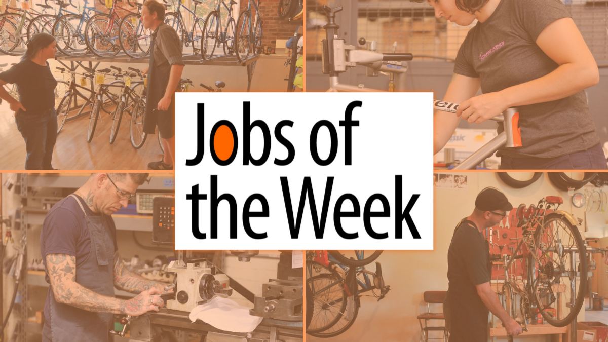
Need a job? Want a better job? Just looking for a change? You are in the right place. Don’t miss these recent job announcements. (Remember, you can always stay abreast of jobs as soon as they get listed by signing up for our Job Listings email.)
These are paid listings. And they work! We’ve helped hundreds of people find great jobs and great staff members. If you’d like to post a job on the Portland region’s most popular bike and transportation news platform, you can purchase a listing online for just $100. Learn more at our Job Listings page.
A scene from the 2020 Chariot Wars. (Photo: Jonathan Maus/BikePortland)
I hope everyone is having fun on all the great rides going on. Remember it’s Bike Summer Pedalpalooza season so you’ll want to check the official calendar and/or grab the Bike Fun App (iPhones only) for all the ride options!
Check out my picks for the best things to do for bike lovers this weekend…
Saturday, July 20th
Ride the Dirt Wave at Whiskey Run Trails – All Weekend (Coos County) A full weekend of fun trail riding, enduro racing, and hang-out time with fellow dirt worshippers. More info here.
Advertisement
Stark Street Swooper – 9:30 am at Ventura Park (E) Sometimes the ride description tells me enough about the leader that I can almost guarantee an interesting ride. Yeah. More info here.
Cycle Cats Do The Slough – 9:30 at Alberta Park (NE) Grab some chamois shorts and snacks for this adventurous ramble into the north Portland nether worlds along and beyond the fabled Columbia Slough. You’ll find unsanctioned trails, natural wonders, industrial wastelands, and who knows what else. More info here.
Zoobomb’s Chariot Wars – 11:00 am at Colonel Summers Park (SE) “As always, the theme is Mad Max and bacon,” says the ride organizer. Yes it’s the legendary Chariot Wars where gladiators mount DIY-steeds and the last team standing takes home the coveted trophy. Bruch first, then it’s war. More info here.
Advertisement
Bike Play – The Game of Bike – 7:00 pm at Wilshire Park (NE) Final day to catch the 15th annual showing of what I’ve called the best event of Pedalpalooza. This is a real theatrical production with professional actors who lead a group bike ride to each scene. Truly a Portland classic and must-see event. More info here.
Sunday, July 21st
Explore Vancouver – 9:00 am at George C Marshall Elementary (Vancouver, WA) Join an experienced ride leader for this 31-mile road ride that will journey out past Vancouver Lake and roll through many points of interest including public art and a land bridge. More info here.
Red R Criterium – 10:00 am to 3:00 pm in Swan Island (N) Come watch super-fit cyclists speed around a short course as they race for “primes” (prize laps) and jostle for position in the big bunch sprint at the end. Or who knows, maybe someone will sneak away for the solo win. You never know what surprises a crit holds. More info here.
Yellow Bike Ride – 11:00 am at Fields Park (NW) Got a yellow bike? Yellow clothes? Just a fan of the color? Roll out and bathe in this wonderful hue among a sea of brightness. More info here.
— Did I miss your event? Please let me know by filling out our contact form, or just email me at maus.jonathan@gmail.com.
Members of the BAC at a group ride in the Cully neighborhood in October 2023. (Photo: Jonathan Maus/BikePortland)
Much of what we love about Portland was created on the backs of hard-working volunteers. I can’t think of many better illustrations of that than the city’s Bicycle Advisory Committee. BAC members have had had an incalculable influence on Portland’s bike network over the years, and now you have an opportunity to join this illustrious legacy.
The BAC is hiring.
If you are someone who likes to tell the Portland Bureau of Transportation how to make bicycling better — and wants to work in collaboration with city staff and fellow advocates to reach our mode share goals — now is the time to apply. The BAC meets monthly and their agendas are full of interesting topics and presentations from agencies and advocates from around the region.
Advertisement
If TriMet wants to redevelop a parcel of land near a MAX station and needs feedback on how to route a bikeway through, they come to the BAC. If Portland Parks & Recreation wants to redevelop a park and has questions about how to fit a bicycle route through it, they come to the BAC. If PBOT has some wild idea they need to vet with folks outside the Portland building who have on-the-ground knowledge and a connection to us regular folk, they come to the BAC.
It’s also fun and you get to do rides together and meet really neat people.
The BAC is the one government meeting that I try to never miss and I’ve seen first-hand for almost two decades how important it is to have the right people around that table. Suffice it to say, it’s a valuable and important body and we need more than just warm bodies in its membership. It could especially use more people who are not white and well-off.
Below is the meaty part of the official job listing:
Advertisement
The City’s Bicycle Advisory Committee convenes monthly to advise City Council and all departments of the City on all matters relating to the use of the bicycle as a means of transportation and recreation. The body is a perpetual committee. The BAC is comprised of individuals with interest in advising the city on matters related to bicycle transportation.
PBOT convenes the Bicycle Advisory Committee (BAC) to provide advice and support to the PBOT, City Council and all City agencies.
The role of the BAC includes but is not limited to:
Review and make recommendations on planning documents prepared by City departments affecting the use of the bicycle.
Review and make recommendations regarding funding priorities for Bicycle Program activities and Capital Investment Projects.
Monitor activities of other jurisdictions as they affect bicycling in the City.
Review and make recommendations on Capital Improvement Projects developed by City departments and outside agencies to ensure adequate consideration is given to bicycling.
Advise Bureau of Transportation staff on issues related to public involvement in Bikeway improvement projects
Provide input on the strategy for incorporating equity into PBOT’s work and direction on the inclusion of communities that have been traditionally underserved by PBOT.
Advise City staff on issues related to promoting bicycle safety and education
Provide input for strategy for building a framework for mobility and transportation justice to mitigate against gentrification and displacement of communities of color and low-income communities.
Encourage community participation in identifying problem areas, reviewing existing facilities and planning and implementing new projects and programs.
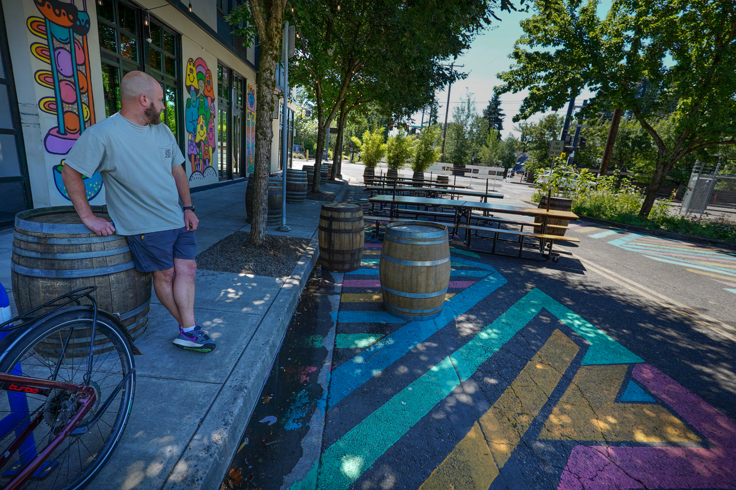
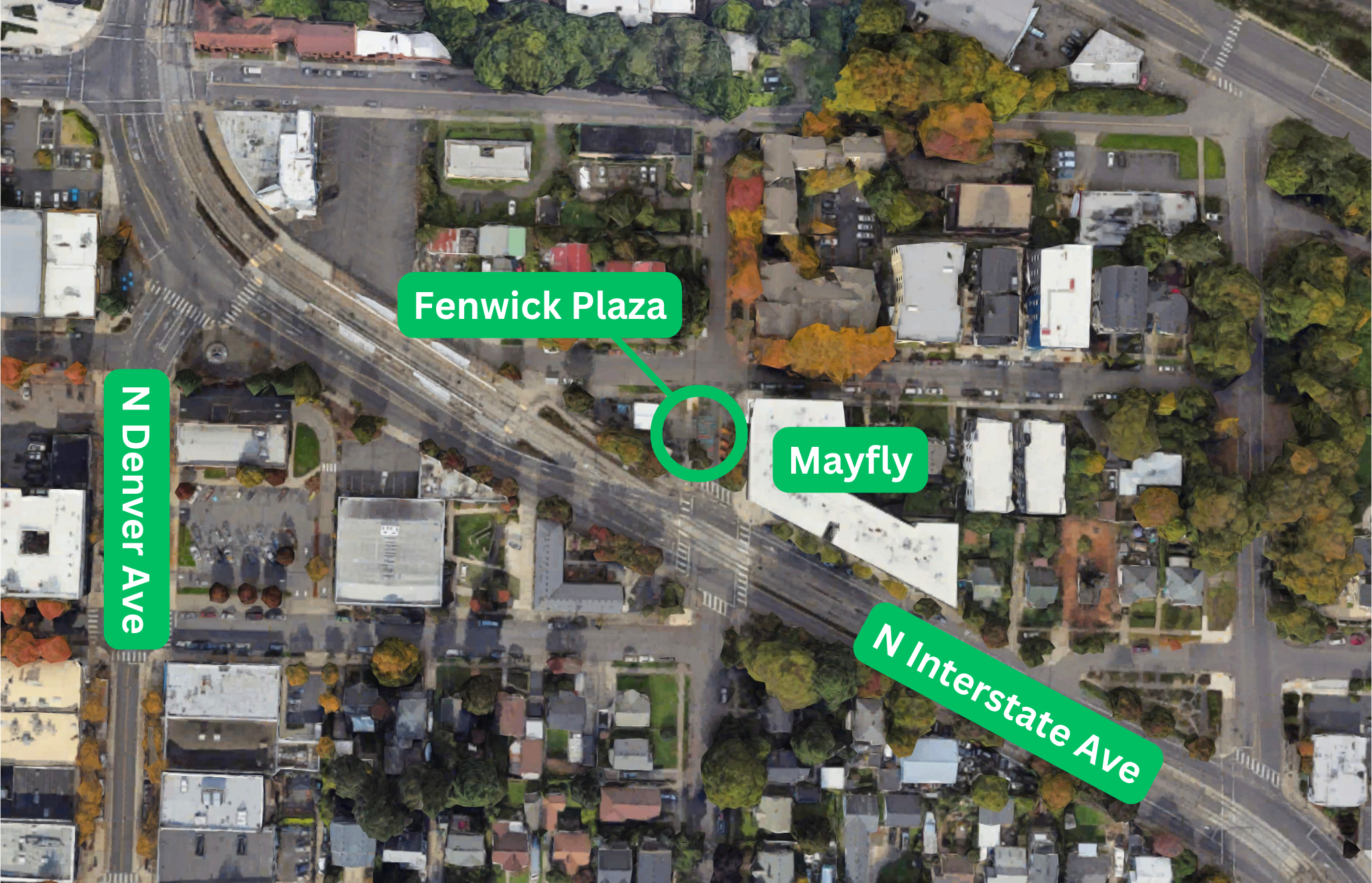
Ryan Born is uncertain about the future of the carfree plaza outside his business in Kenton. (Photo: Jonathan Maus/BikePortland)
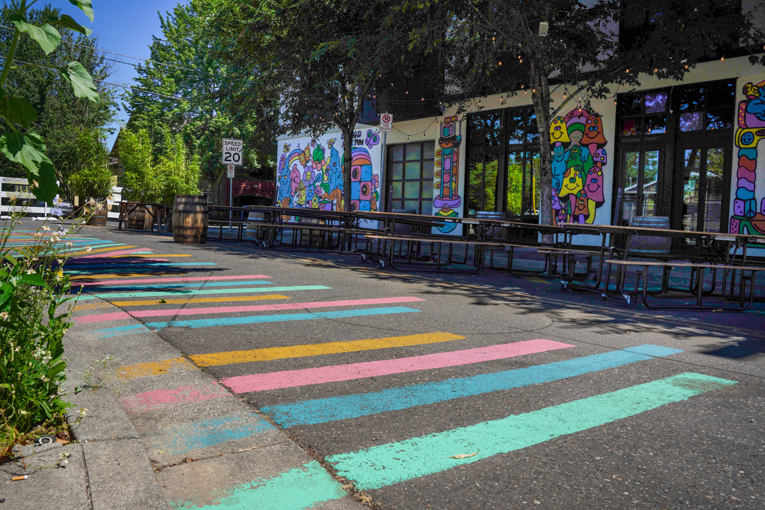
By all accounts, Ryan Born, owner of the Mayfly Taproom in Kenton, has been a model Portland business owner and street plaza steward. Since the City of Portland’s Covid-era public plaza first opened outside his corner location on North Interstate and N Fenwick in April 2021, he’s hosted hundreds of community events in the street.
So he’s shocked and disappointed that the Portland Bureau of Transportation recently told him they will need to remove the plaza later this year.
“Help Save Fenwick Plaza” was the all caps headline of an email and Instagram post Born sent out yesterday to Mayfly’s thousands of fans. “We need your help!!” it read. “PBOT is planning to remove the plaza this fall and we need to show them the positive impact that it has had for our neighborhood!”
Advertisement
Born says he was told by a PBOT representative during a July 1st meeting they intend to remove the Fenwick plaza — which extends between N Willis Blvd and N Interstate Ave — and reopen the street to cars and drivers this fall. They’ve offered to keep one lane open for car users and the other for dining tables, or continue it as a pop-up weekly or seasonal plaza space — but none of those options appeal to Born. As he understands it, the plaza doesn’t meet PBOT’s criteria for a full street plaza and there’s currently no business permit available that covers full street closures.
Just what exactly that criteria is, has yet to be shared by PBOT.
Part of the issue here is that PBOT in in the midst of transitioning the plaza program from pandemic pilot to a permanent part of the agency’s portfolio. That process began in March 2022 with a press conference in a plaza downtown where former PBOT Director Chris Warner told news cameras, “We really want to keep this going and create a new Portland.”
Advertisement
Then commissioner-in-charge of PBOT, Jo Ann Hardesty, said in a speech that, “Every neighborhood should have a welcoming place where community members can get together and enjoy each other… so that we can use our streets for people, not just for automobiles.”
Born is frustrated because he feels like he’s managed a model plaza on a street that doesn’t serve much automobile traffic and he hasn’t been told what it would take to meet PBOT’s requirements to make it permanent.
“We were informed by PBOT that we do not meet their criteria as a ‘public’ plaza,” Born shared in an email to BikePortland. “We then asked them for copies of their criteria and we were told that ‘it doesn’t yet exist but we don’t imagine that you will meet the criteria when it is written.'”
I’ve asked PBOT to clarify their position and justification for threatening to close this plaza, but have yet to hear back.
Advertisement
(Photos supplied by Mayfly Taproom)
There could be several issues at play here.
Centers map from City of Portland 2035 Comprehensive Plan.
PBOT might feel like the adjacent land use at the N Fenwick location doesn’t meet requirements for a “public plaza” because the only thing that borders the plaza is Born’s taproom. PBOT’s 2023 Street Plaza Annual Report states, “Not all parts of Portland are suitable for street plazas. Plazas fare best in dense, walkable urban spaces near main streets and commercial areas. Auto-oriented areas and major transportation routes in Portland tend to be less suitable for plaza uses.”
The Fenwick Plaza also isn’t within one of the “neighborhood centers” identified in Portland’s 2035 Comprehensive Plan — a designation that applies to areas with a mix of high population and mixed-use activity.
Born rejects the idea that his business is the sole beneficiary of the public right-of-way. He doesn’t require people to purchase anything to use the plaza and he doesn’t collect fees from vendors at events. Born claims to have collaborated with over 60 small businesses in the past six months alone. And the Kenton Business Association Board sent a letter to PBOT on July 16th that supports that contention. “This plaza has taken an unnecessary, and often dangerous, connector street and turned it into a hub for our community members and a draw for residents throughout the metro area,” reads the letter (which was also signed by the Kenton Neighborhood Association).
Advertisement
PBOT might also be acting from budgetary concerns. The federal Covid relief funds from the federal government that paid for the launch of the plazas ran out last summer, so now PBOT is faced with how to integrate 18 plazas into their annual expenses.
When I met Born in person during a visit earlier today, he said he’s spent thousands of dollars of his own money to make Fenwick Plaza a success. He seems willing to do just about anything to keep the street carfree. “This has been a huge part of my business,” he said. “It’s why we’re still open and we’ve had hundreds of customers already reach out to PBOT to show their support for it.”
I’ll update this story when I hear back from PBOT.
UPDATE, 6:11 pm: PBOT spokesperson Dylan Rivera has shared the statement below with BikePortland:
PBOT’s meeting with Mayfly was the beginning of many conversations that we will have with the neighborhood and businesses about where they think the City should be investing in public space for the Kenton area, how we can spend limited resources, and how we can leverage the energy and creativity of the community there.
A Public Street Plaza is a space that closes the full width of a street, with furnishings and materials typically contributed by PBOT. This investment is typically most appropriate along a commercial corridor or center, where it can benefit the most people and businesses. PBOT envisions public street plazas as regular gathering space for the community at large. The spaces should be welcoming for everyone, active and vibrant for the community, and where people feel comfortable being in the plaza space without making a purchase.
We look forward to having an open dialogue with the community to identify the location that best serves Kenton as an open, public area while supporting small businesses like Mayfly.
Across the city every situation is different, and it can be difficult to find a way to be fair to everyone about the use of public space. This will be an ongoing conversation as the City’s Public Street Plaza Program evolves.
Mayfly has done a wonderful job creating a community space over the last few years and we are grateful for businesses like them who see themselves as community builders in addition to the daily challenges of running a business.
PBOT is scheduled to meet with the Kenton Business Association and the Kenton Neighborhood Association at their next meetings.
If the N Fenwick location did not continue as a public street plaza, PBOT thinks there may be some other workable options for Mayfly that would still allow for them to use street space, like our Outdoor Dining Permit, and fully activate and close the street on a more temporary basis (as opposed to a 24/7) for community events they hold with a Community Event Permit. We’ll be continuing to have those conversations with them with the hopes of finding a workable solution for all.
In summary, we are grateful for Mayfly’s efforts and recognize how valuable they have been to the neighborhood community. We plan to continue to work with them and other businesses to find solutions to evolve the spaces that were established during the Covid-19 pandemic into usable spaces that meet the needs of Portland today. We are excited to see where the conversation with the Kenton neighborhood takes us.
Note: This is a relatively vague statement and I’ve followed up with more detailed/specific questions.
View looking south on downhill section of SW Capitol Hwy at intersection with SW California. SW Florida, where police say first responders were called to, is in upper left of image.
UPDATE, 7/25: PPB says Gad Alon died from, “a significant medical event.”
The Portland Police Bureau announced Wednesday evening that a man who fell from his bicycle while riding in in the Multnomah neighborhood 10 days ago has died from his injuries.
According to police, first responders were called to the intersection of Southwest Capitol Highway and SW Florida Street just before 7:00 am on Saturday, July 6th to help someone who seemed to have fallen off their bicycle. The man, 74-year-old Gad Alon, was taken to the hospital.
In a statement, the PPB said they were not called to the scene because, “there was no indication of a crime or traffic crash involving anyone else.” The PPB Traffic Investigations Unit has since taken on the case and says, “At this point, there is no indication that any drivers were involved.”
Alon died at the hospital Wednesday morning. He’s the third person to die while riding a bicycle in Portland this year.
Advertisement
I’ve asked PPB to share more details about the case in order to better understand Alon’s route and what might have led to his death. Since the investigation just began yesterday, they aren’t able to share which direction he was riding or where his bike and/or body was found when EMS first arrived.
If Alon was going north on SW Capitol Hwy (toward SW Vermont) he would have been going downhill for a block or so before coming to the SW Florida intersection. The bike lane ends abruptly right before that intersection and a curbed sidewalk juts out into the street.
In the southbound direction (toward Multnomah Village), Alon would have been in an uphill, unprotected bike lane as he approached SW Florida.
Advertisement
David Stein, a southwest Portland resident and cycling advocate who has served on the city’s bicycle advisory committee, said this section of SW Multnomah is a good example of why very few people ride in the area. “If you’re going toward Multnomah Village the facility is bad due to the persistent foliage growth blocking the uphill bike lane. Going downhill toward Hillsdale you lose the lane… These low quality routes to destinations are part of what make riding a bicycle in southwest so challenging.”
If you know more about what happened to Gad Alon on July 6th, please contact me. Also share your information with the PPB via crimetips@police.portlandoregon.gov with “Traffic Investigations Unit” and case number 24-178154 in the subject line.
Velotech, Inc. is a locally owned business that has operated in Portland since 2002. Velotech is the parent company of BikeTiresDirect, Western Bikeworks, and Trisports.
We are always hiring! We have flexible schedules that accommodate multiple needs. We are currently looking for full time, but if part-time works best for you, feel free to reach out as well. We love to promote from within, so if you are looking to get your foot in the door, this could be a great entry point.
This position is responsible for picking, packing and shipping customer orders. Qualified Shipping Specialists also execute product put-away, clean their work area, execute physical counts, and available for general physical and/or minor administrative labor.
Starting rate is $17.75 per hour.
ESSENTIAL FUNCTIONS INCLUDE BUT ARE NOT LIMITED TO:
Pick incoming web orders and warehouse pick up orders.
Pack and ship orders according to supervisor’s guidelines.
Maintain accurate inventory through regular cycle counting.
Assist receiving department with put away of new items.
Maintain a clean and organized workspace.
Assist with any projects, or assist in other departments as instructed by supervisor.
Perform all duties in a safe manner and report all safety concerns immediately to supervisor.
MINIMUM JOB REQUIREMENTS:
Wear closed toe shoes at all times in warehouse.
Be able to lift 25 lb above your head without assistance.
Stand for long periods of time.
Be able to lift 50 lb without assistance.
KNOWLEDGE, SKILLS, & ABILITIES:
Excellent communication and organizational skills.
Solid knowledge of cycling products.
Ability to work in a high volume, fast-paced environment.
Ability to work independently or with others to manage multiple task with minimal supervision.
BENEFITS:
Generous Employee Discounts
Flexible Schedules
Medical/Dental/Vision for all full & regular part-time employees
Paid Time Off – up to 15 days your first year
Quarterly ‘Get Outside’ days
PHYSICAL/MENTAL DEMANDS:
The physical demands described here are representative of those that must be met by an employee to successfully perform the essential functions of this job. Reasonable accommodations may be made to enable individuals with disabilities to perform the essential functions. While performing the duties of this position, the employee is regularly required to talk or hear. The employee frequently is required to use hands or finger, handle, or feel objects, tools or controls.
While performing the duties of this job, the employee is regularly required to stand; walk, reach with hands and arms, stoop, kneel, crouch and sit for extended periods of time.
The employee must occasionally lift and/or move up to 50 pounds. Specific vision abilities required by this position include close vision, distance vision, color vision, peripheral vision, and the ability to adjust focus.
The noise level in the work environment is usually moderate.
This description is intended to provide only the basic guidelines for meeting job requirements. Responsibilities, knowledge, skills, ability and working conditions may change as needs evolve.
Velotech is an Equal Opportunity employer.
How to Apply
If interested, please click on the link below to apply (or copy and paste into a browser). You can also find us on biketiresdirect.com careers page.
An illegally parked car in Sellwood Riverfront Park on Sunday, July 14th (Photo: Johnmark Larson)
People are driving cars in Portland Parks, upsetting the traditional calm and carfree respite many seek when visiting them. Two recent incidents stand out as just the latest examples of an erosion of norms around safe driving.
On the night of Monday, July 8th a man was relaxing in Creston Park in southeast Portland when the driver of a blue SUV hit him and then fled the scene. The mom of the victim posted to Nextdoor in hopes of finding the suspect. Here’s an except from the post:
“He was lying on the grass and hit by a car ‘presumably joyriding’ through the park. He sustained multiple injuries and is healing. Although he was unable to clearly identify the make and model of the car, the car is blue – the car sustained a smashed windshield and dented hood due to the impact. His glasses, keys and headphones were strewn over 30 feet behind him, he was hit hard and head on. If you have any information or witness a car that may have sustained these damages in the last 24 hours, please reach out to the Portland PD. Thank you for keeping your eyes out for me.”
Advertisement
Screenshot from KOIN-TV video.
The victim gave an interview to KOIN TV that aired Friday. “I was just trying to relax a bit before bed,” the man said. “I’m laying down and headlights come in my peripheral, so I immediately stand up and I turn around, and the car is like directly in front of me.” The driver of the SUV was reportedly going “full speed” through the park prior to the collision. The impact left the victim with serious lacerations on his leg and face.
“If I wasn’t aware, I’d be dead,” the victim said.
Another person interviewed said they’ve seen people “doing donuts and other things with their cars” in the park.
And this past weekend, Sellwood resident Johnmark Larson reached out to share their concerns about people parking and driving in Sellwood Riverfront Park. Crowds have flocked to the park to cool off during summer, leaving no more room to legally park. “I first noticed the issue while riding down the Springwater on Sunday afternoon.” Larson shared. “I thought maybe there was a permitted event, but then I saw it all again last night and it’s clear this is the next step in anything-goes overuse of the park.”
Advertisement
Larson contacted the Portland Parks ranger hotline to file a complaint and says the staffer on the line had also seen people driving and parking on park grounds. Portland city code prohibits parking cars on parks properties without a permit.
This is just the latest example of how some drivers are so entitled and selfish they feel like laws don’t apply to them. Whether it’s speed racing on our streets, not having a license plate or current registration, driving on carfree paths, or destroying the calm and safety of our parks — it’s clear the lack of action by Portland city leaders to defend public space from miscreant car users has led to widespread normalization of extremely dangerous behaviors.
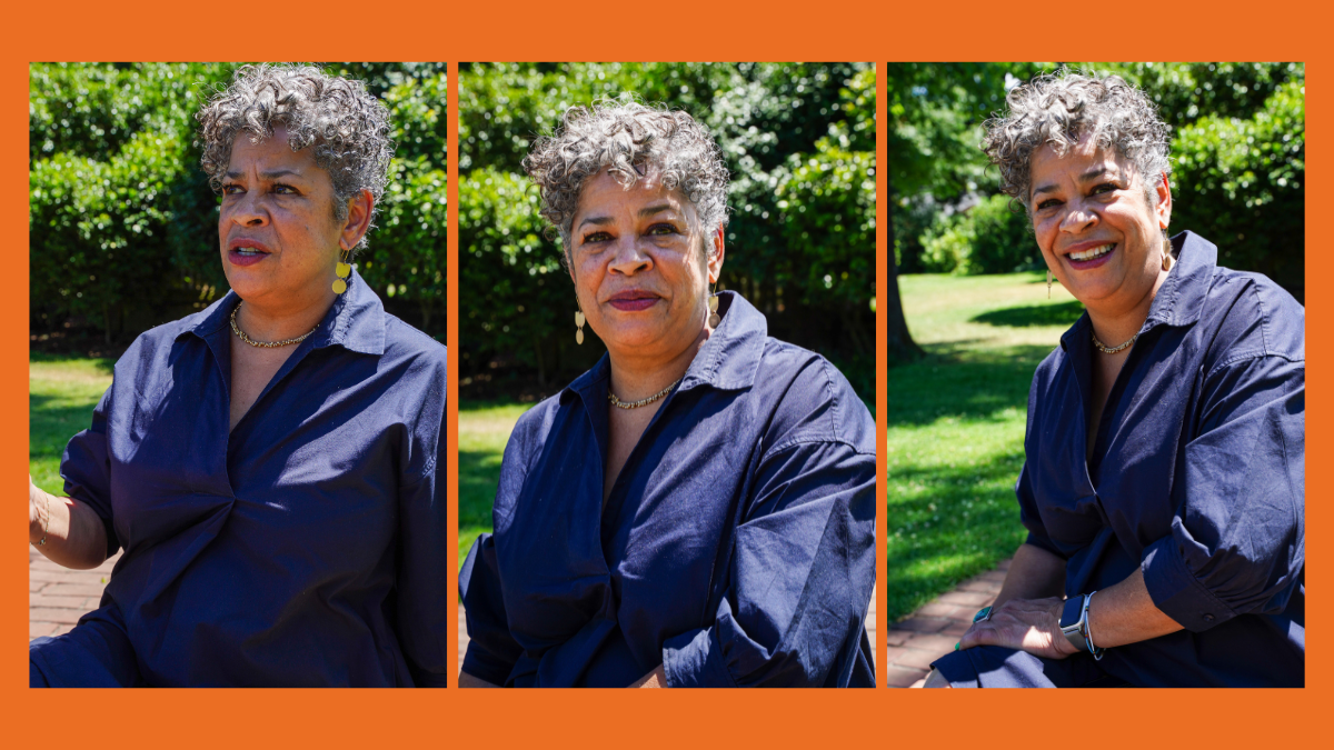
Michelle DePass in Peninsula Park on July 15th. (Photos: Jonathan Maus/BikePortland)
Michelle DePass learned about the value of walkable neighborhoods from her grandmother, who taught her from a very young age that if she wanted a reliable way to get around she better take care of her feet and shoes. “My brother asked my grandmother one time, ‘Where is the car?’ and she pointed [at his feet] and said, ‘Right there. There’s your car.’ I just remember my grandmother taking care of her feet really well. That was her mode of transportation,” DePass shared with me on Monday during a conversation in Peninsula Park.
DePass is running for a seat on Portland City Council to represent District 2 (north and northeast), and she figures she’ll wear through two pairs of shoes walking and knocking on doors to convince voters to send her to city hall. She knows the district well not just because her family has been a part of it since the 1940s (her parents met at Dawson Park), but also through her role as chair (and currently vice-chair) of the the Portland Public School Board. In addition to that elected position (which she’s held since 2019), DePass works as a climate change analyst at the City of Portland Bureau of Planning & Sustainability.
Our chat in the park came 13 years after DePass stood up during a meeting of the North Williams Avenue Traffic Safety Project and expressed concerns that the process and plans for a new bike lane was severely misguided because the people pushing for it were clueless about the lived experience of Black Portlanders and the historical context of the neighborhood. “That was an example of my leadership,” DePass shared when I brought up that meeting. “We were literally in the hospital where I was born talking about that project. And I just thought, I studied this in school, there’s an intersection between race and transportation.”
Advertisement
Her voice not only altered the course of the Williams Avenue project, but had a vast influence on bike planning and advocacy in Portland in general. It was the first of many difficult, yet important, lessons Portland’s bike advocacy community would be forced to confront in the years to come. And it was just one of many topics we covered in this interview.
Here are some excerpts:
On her job as leader of PPS Board and how it will translate to city council:
“The school board is the toughest political job in Oregon. It’s really, really challenging. When I was the chair we had to engage the police in protection. We’ve had to beef up security… And then it’s also tough because you have to make decisions with at least three other people. So I think that the experience I bring is in decision-making. In a shared decision-making model your ability to be effective depends on how well you relate with other people, you have to be able to sell your idea and you have to be able to have someone else tear it down and say ‘That’s good, but I’d like to tweak it.’ … I have the ability to have a difficult conversation. I don’t get too emotional about it. But I do have a strong sense of right and wrong.”
Advertisement
On the concept of ‘school streets’ (making streets safer in front of schools):
“I’m 125% in favor of it. And in fact, last year, I started to broach this idea… I’m having coffee with somebody and saying, ‘You know, you’re gonna say no, but I have this great idea: What would it look like if I could get all the resources, including a free pilot, to take a look at our school campuses and see which ones we could put mechanical bollards up at either end of the street, to keep cars out to keep it active for parents and children?’… I can envision it. I don’t know which schools they would be at, but it’s something that I want to advocate for.”
On carfree Last Thursday street fair on NE Alberta St:
“I love that. And I love riding [my bike] on Alberta, because I just feel like a 12-year old whenever I ride down Alberta because I’m like, ‘Yeah, there’s no bike lane. And it’s just, you know, I got this!’ I don’t ride long stretches, I have a helmet on, and I’m very, you know, I can be aggressive. I can take a lane. I’m not afraid of doing that. It’s my street as much as anybody else’s. And I feel like I’m entitled to it when I’m on it.”
Asked to name a transportation issue in her district that needs attention, she mentioned I-5 through the Rose Quarter. She said she supports the highway caps, but when pressed to say whether or not she supported ODOT’s plans to widen the freeway, I didn’t hear a clear answer.
On the freeway itself:
“There’s a freeway that runs through the district that is a scar… like in many communities around the country, it goes through the most vulnerable neighborhood and gets built and it tears the community apart.”
Advertisement
You support the caps, but do you support ODOT’s plan for the freeway elements of the project?
“Not necessarily.”
Do you trust ODOT and the freeway elements of it?
“That’s a great question. And I was expecting that question coming from you. I think we’re looking at it as an either/or situation; but I’m always interested in finding out what the hybrid looks like. And that’d be something I would be willing to explore.”
Do you think ODOT’s current plans for the freeway will make climate change consequences worse?
“Oh yeah. It will absolutely.”
Advertisement
In this exchange, DePass shared how her style is to build relationships with people she’s critical of and discuss issues privately, instead of rabble-rousing in public:
“I know people that are working on that project that are decision makers, and we have a relationship so that I can push, push, push, push, push. And that seems to be effective for me. The activism part of me is gone. That part, the fighting piece, is gone because that hasn’t been effective and I want to be the kind of activist that’s extremely effective. I found that standing on the side and screaming, that’s our right to do that, but it’s also not very effective. So I would use my power — I have a position of power right now — and I’d like to use that to have the conversations offline that make change. Nobody sees those conversations except for me. But that’s how I’ve been effective on the School Board… taking things out of the public realm and having a one-on-one conversations to make change.”
Last week we opted for the shade of Ankeny Tap. This week we’ll be back on the Gorges Beer patio. (Photo: Jonathan Maus/BikePortland)
We have a special night planned at Bike Happy Hour tomorrow (Wednesday, July 17th). City of Portland staffers will be on-hand to help us understand what’s in store with the upcoming election and our transition to a new form of government.
If you’ve read some of our previous reporting on the charter reform effort, you’ve already done your homework. Or if you’ve clicked on those nice Ranked Choice Voting banners on BikePortland for the past few weeks, you might have already started learning about how the new voting process will work. Regardless, tomorrow night will be an excellent opportunity to get a hands-on education.
Advertisement
Vote here! Learn results at Bike Happy Hour, Weds, 7/17.
In addition to ranked choice voting experts, we’ll have City of Portland Charter Transition Project Manager Shoshanah Oppenheim in the crowd to answer all your questions about how things will work on January 1. How will the role of PBOT director change? How will the new Public Works Director manage PBOT? If no city council member is in charge of PBOT, how will transportation policies and projects get proposed and voted on? What other questions do you have for Shoshanah?
To spice things up, staff from the city elections office will do a short presentation about ranked choice voting that includes a mock election. We came up with nine candidates and the question to rank them with is, “What is the most important off-street path in the Portland cycling network?” You can visit this website and begin your voting now. We’ll also have a QR code to hit at Bike Happy Hour so you can make your decisions on the patio tomorrow night.
In addition to nerding out on elections and government, we’ll be joined by at least one city council candidate. District 2 candidate Jennifer Park will join us and will say a few words around 5:00 pm.
It will be a great night. Hope you can join us. (Bike Happy Hour is 3-6 pm every Wednesday at Gorges Beer Co on SE Ankeny Rainbow Road)