![]()
“It seems silly to have the most protected persons with the fewest interactions have all the space designated for them and very little of the road discomfort.”
— Michael Reiss
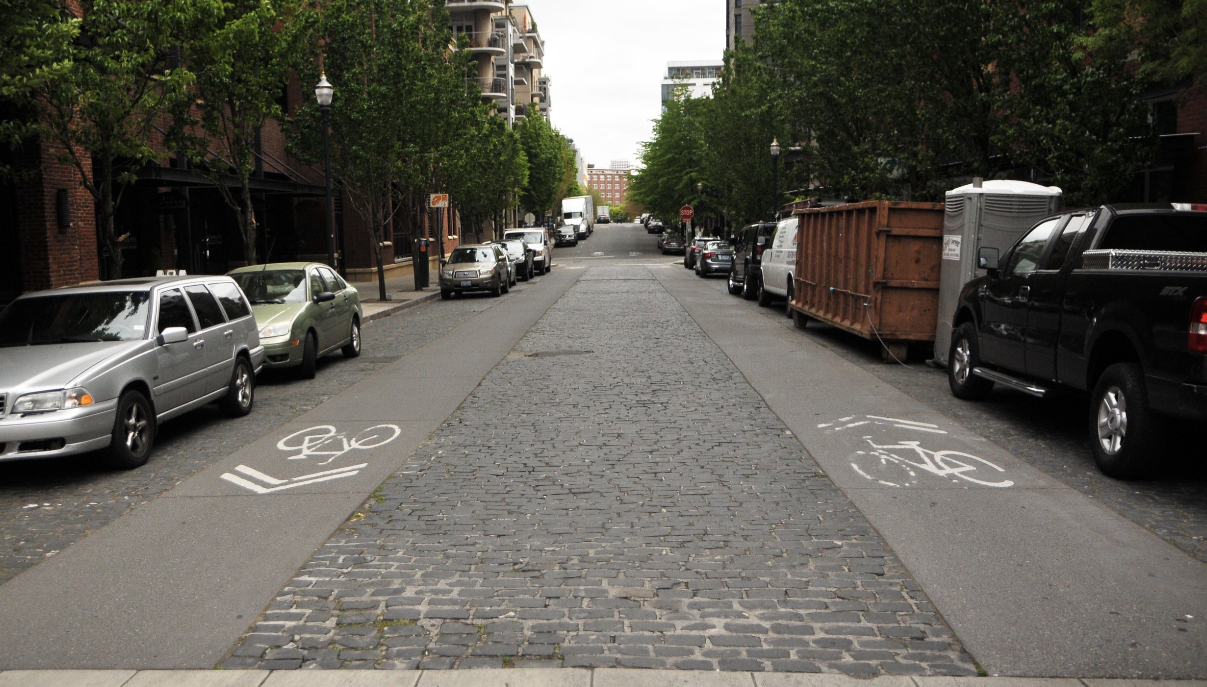
Southwest Portland resident Michael Reiss is ready to grab some neighbors, a bucket of paint, and have at it. “It” being painting “advisory shoulders” on SW 18th Place, and maybe Maplecrest Drive and 14th too. He’s done his research. He says measuring, designing, and calculating are all in his wheelhouse. And committee meetings? — not so much. He doesn’t like waiting for years.
The advisory shoulder concept his research led him to is an experimental design used on narrow streets with low car volumes that don’t have width for the full suite of facilities — two general purpose lanes, sidewalks and bike lanes — like most streets in southwest Portland. The design reduces the two travel lanes to one bi-directional lane, in which drivers going in opposite directions may pass one another by entering into the advisory shoulder when no people are present. The genius of the design is that it simply formalizes the interactions that regularly occur on narrow roads when a driver pulls to the side to let another driver pass, taking care not to hit anyone.
Advertisement
An engineer by training, Reiss gathered his data, including histograms of travel speed and car counts by hour. His most convincing results are his “number of interactions per trip” for an area walk:
“For pedestrians, an average 30-minute walk results in over half a dozen passes by car users (in either direction). For drivers, even at the times of highest traffic, they average two opposite direction passes with other vehicles. It seems silly to have the most protected persons with the fewest interactions have all the space designated for them and very little of the road discomfort. With advisory shoulders, those two passes would require the drivers to simply (safely) veer into the shoulders.”

Reiss’s aversion to committee meetings might be why he was unaware that the Portland Bureau of Transportation (PBOT) and the Southwest In Motion (SWIM) process, after five years of meetings, had reached the same conclusions he had. In fact, the Bike Plan for 2030 and SWIM had already identified a collection of streets in southwest which would be good candidates for the treatment, including SW 18th Pl and Maplecrest Dr. SWIM even designated two streets on its project list as “pilot” projects for experiment and analysis—SW Talbot and SW Cameron/45th. In the 2019 SWIM project manual, PBOT’s enthusiasm rivaled Reiss’s:
Next Steps for Implementation
PBOT plans to participate in an experimentation and analysis process to conduct pilot project implementation to learn more about where this facility type works best. Southwest Portland has much to gain from successful implementation of advisory shoulders and the inclusion of this design into the PBOT road safety toolbox.Upon successful pilot installation, PBOT should conduct a citywide analysis of potential streets and contexts appropriate for Advisory shoulder implementation. This study should identify appropriate criteria or mitigation for southwest specific concerns related to sight distance, lighting, and operating speed.
Experimentation is required because the advisory lane design is not yet approved in the Federal Highway Administration (FHWA) Manual on Uniform Traffic Control Devices (MUTCD).
Jessica Horning is ODOT’s Bicycle and Pedestrian Coordinator and is listed as a contact by the FHWA. I called Horning to learn about the experimentation process. She explained that the MUTCD is overhauled every 10-12 years and that a new edition is currently in the works. In the decade between updates, a DOT can “request to experiment” on a new road treatment. The process includes 1) Identifying a university partner to conduct a before and after study and 2) determining if you got the expected behavior. “If you get the results you expect, you can then do a larger study,” said Horning. After interim approval, a DOT can send the FHWA a list of streets on which it wants to expand the design. PBOT has completed experiments with the FHWA in the past with green bikeways and bus lanes.

A search of the MUTCD Official Rulings yielded seven cities with active advisory lane experiments. Portland was not on the list. Nor could I find any sign that PBOT had taken action on its pilot streets in southwest — Talbot and Cameron. It appears PBOT has not moved forward on its advisory lane experimentation, although they appear to have made attempts in (at least) two locations: NW Marshall (between 12th and 14th) and SE Caruthers (between SE Grand and the Esplanade path). PBOT did not respond to BikePortland queries in time for publication.
If they work as intended, advisory shoulders would be a boon to southwest Portland where most residential streets don’t have sidewalks, and neither do 65% of the collectors and arterials, (stats which make southwest Portland the area of the city with the worst sidewalk coverage, by far). Add to that the lack of bike infrastructure, sparse bus service everywhere but Barbur Blvd and Beaverton-Hillsdale Hwy, and the Portland policies promoting increased housing density in the region, and you have a recipe for Carmageddon, with residents having few alternatives to car travel.
Meanwhile, it’s spring in Portland, DIY-infrastructure-improvement-projects are in the air. And Michael Reiss is a man on a mission. Stay tuned.
###

— Lisa Caballero, lisacaballero853@gmail.com
— Get our headlines delivered to your inbox.
— Support this independent community media outlet with a one-time contribution or monthly subscription.


Thanks for reading.
BikePortland has served this community with independent community journalism since 2005. We rely on subscriptions from readers like you to survive. Your financial support is vital in keeping this valuable resource alive and well.
Please subscribe today to strengthen and expand our work.
I love seeing neighborhood enthusiasm for these ideas. Here are a couple resources for people who want to learn more:
More information on this design in the FHWA Small Town and Rural Multimodal Networks Guide: https://ruraldesignguide.com/mixed-traffic/advisory-shoulder
And documentation of the (limited) American experience with this design from Portland’s own Alta Planning + Design: https://altago.com/wp-content/uploads/Advisory-Bike-Lanes-In-North-America_Alta-Planning-Design-White-Paper.pdf
There is still so much we need to learn about how to use this tool to improve safety and mobility in our walking and biking networks.
Thank you Nick! those are good resources.
This is one good too:
https://www.advisorybikelanes.com/
In particular, the 2nd video in the “video links” section is worth watching. It shows a mixed ped/bike shoulder in action in Princeton, NJ on a fairly busy (all modes) 25 MPH road.
It would work even better in many places in SW Portland.
Except for Bloomington Indiana, none of the examples shown are anything like the ABLs in the Netherlands, Belgium, UK, & Germany, not when car parking is allowed on one or both sides of the street in nearly all these US cases. The idea behind ABLs is to create a shared space that is safe for all users in a narrow confined right-of-way. In the US examples, the right-of-way isn’t even remotely confined – there’s sidewalks, there’s planting strips, 1 or 2 parking lanes, and very wide center lanes for cars. In most cases, a more appropriate response would be to remove all or most of the parking and put in buffered bike lanes.
The E 7th example in Bloomington also has sidewalks for people walking (my parents live in Bloomington).
https://goo.gl/maps/ZbHq1uWMHfUdrCdE9
The intent behind ABLs is to create space for people biking when there isn’t room for conventional bike facilities. The proposal that people walking should share ABL space with people riding is, IMO, an example of USAnian transportation exceptionalism.
Don’t believe me?
Well…you might want to check out Roger Geller’s presentation on ABLs:
https://bikeportland.org/wp-content/uploads/2014/09/advisory-bike-lanes-geller-presentation.pdf
This lane configure is common in the Netherlands for narrow roads. Motor vehicles use the center but can use the sides to pass, but non-motor users have priority on the side. It is also a good lesson in decision site distance since you share a lane with oncoming traffic.
I also like the way they put large flower planters in the road. If you are not paying attention or driving too fast you will total your car and have to buy the local council a new flower pot. Kind of weeds out the idiots.
Finally finally a chance a real local urban examples! It makes so much sense. Fingers crossed (I tried to get the City of Vancouver WA to do this on Evergreen Blvd in the Historic Reserve 15+ years ago…you know that narrow street with all those 1860s generals’ homes.) Now is definitely the time.
Just remember if someone says ‘it is unsafe’…its actually similar to the shared left turn lanes on arterial road diets in many neighborhoods that we all use daily…but slower speeds.
Sorry, but I think “motorists” need to become much more skilled before this design can work. Everything about US road design tells drivers, “You own the road!” And they drive like it.
I agree. Advisory bike lanes may work in the Netherlands where legal and social systems cause most drivers to have empathy for people walking or biking but the USA is a society that increasingly tolerates road rage culture and massive trucks/suvs that are designed to intimidate and, by extension, kill. Petromasculinity has become a “dominant” political movement/wedge issue and, IMO, Portland is in a very different place from the 2000s when there was still some hope that driver behavior could change for the better.
I agree that we are moving in the wrong direction as far as driver behavior and car culture is concerned. I’m not sure that ABLs are a great solution for Portland. But I’d hate to see PBOT give up on trying to make streets safer through innovative design.
This road treatment is for low ADT and low speeds. It can work in the US with our motorists and is proven to reduce crashes. We need edge lane roads to lay striping that says motorists don’t own the road.
Ironically, the only study of US facilities (posted below by Michael Williams) found that people walking had markedly higher “critical interactions” than people biking on “edge lane roads”. This is a facility for people biking that likely increases risk for people walking by directing them to walk in the road of what will essentially be treated as a two-way road by many drivers. Those of us who bike for transportation know very well that people driving have little regard for dedicated road space for people biking so why would we think people walking who are harder to see and less likely to wear blinky lights and reflective clothing would not be at even higher risk.
Hi Soren,
I think the context is important. In most of the southwest people are already walking in the road. Collectors like Dosch and Broadway don’t have sidewalks, or even shoulders. It’s pretty bad.
One problem that doesn’t get mentioned (or is conveniently ignored) is that the city doesn’t have the stormwater infrastructure in SW to handle more run-off from cement sidewalks, so the city has stopped requiring much new development to build them, thus exacerbating the problem. So the area isn’t getting sidewalks, probably ever. The advisory lanes would be used on small streets that already don’t get much car traffic.
Advisory lanes in Europe and Canada are intended for people biking and when these facilities are installed there are parallel sidewalks (footpaths). IMO, the advisory lanes proposed in the OP are a de facto bike facility that offer no comfort or protection to people walking. In fact, I doubt pedestrian behavior would change much as a result of this kind of facility. For example, in the first image of the OP I would walk in the unmarked shoulder to the left or in the gravel to the right of the advisory lane.
“So the area isn’t getting sidewalks, probably ever.”
The many miles of sidewalks being installed in E Portland were the result of decades of political activism. I hope that the same happens in SW Portland.
This seems like a good option for some streets. Where I have reservations is on narrow streets with heavier foot and bike traffic, and low car volumes. On those, people biking and walking should feel free to use the whole street, with cars yielding to them. Once the stripes go in, my worry is drivers will feel people biking and walking should stay to the sides, because the stripes designate the center for cars only. On those streets, I’d rather see no stripes, but some sort of “SHARE THE ROAD”/YIELD TO BIKES AND PEDESTRIANS” signage that makes it clear people biking and walking have a right to be in the street.
I think what you’re suggesting would be great for streets that are too narrow for two-way traffic specifically because they have parking on both sides. For instance, a whole lot of the neighborhood streets in SE, NE and some of N Portland.
Instead, though, most rollers and walkers are treated as they have no business being in these streets, because drivers need to use them as cut-throughs at 40+mph. And PBOT tacitly endorses this, not only by not having any “yield to bikes/peds” signs, but by having completely uncontrolled intersections — no stop or yield signs at crossings — and maintaining the ridiculous, atypical and dangerous parking-up-to-corners policy which makes sight-lines so problematic.
For streets that have no parking or parking on one side, I like the advisory shoulder idea.
Low speed on these is key. Fortunately, Portland Ordinance 188774 directs PBOT to reduce posted speeds to 5 MPH slower than the statutory speed on all non-arterial streets in residence districts. These SW streets and many similar small streets w/o sidewalks in E Portland and citywide are “narrow residential roadways” for which the statutory speed is 15 MPH. Subtract 5 and bingo: the speed that shall be posted is 10 MPH. Add some calming features (speed cushions, refuge islands, planters, other forms of meanders, zigzag striping, benches, basketball hoops, etc) to achieve that as the actual speed and wow! You’ve got a street that provides calmed vehicle access for people who live there (and deliveries, emergency vehicles, etc) and is truly safe and comfortable… for everyone! 10 MPH signs are already overdue (literally, legally speaking) on streets where the portion of the street “that is improved, designed or ordinarily used for vehicular travel, exclusive of the shoulder” is not more than 18 feet wide. And, 10 MPH is the correct (required) posted speed on any street in a residence district where this sort of advisory shoulder or similar treatment is created.
Like all speed limits, these are not discretionary. Statutes, Portland’s ordinance (and on some larger streets an order of the Speed Zone Review Panel in Salem) dictate a single, correct posted speed for every street. The number they spit out defines the level of safety, quiet, comfort and calm to which people who live on, or near, or use a street are entitled. If you live on a collector, in a school zone, or on a narrow residential street (or know of one) that you think is posted too fast you may want to email safe[at]portlandoregon.gov and ask them to post lower speeds. More details on these types of streets are here: https://bikeportland.org/2020/12/10/portland-should-lower-even-more-speed-limits-legal-expert-says-323813
Problem is Portland and many Portlanders are against any form of traffic enforcement. Drivers know enforcement is non-existent and they drive like it. 🙁
“Add some calming features (speed cushions, refuge islands, planters, other forms of meanders, zigzag striping, benches, basketball hoops, etc) to achieve that as the actual speed and wow! You’ve got a street that provides calmed vehicle access for people who live there…”
If these facilities need traffic calming and speed reductions, why would an advisory bike lane be a better option than an improved neighborhood greenway? (There are multiple neighborhood greenways with stretches that are limited to one-way automobile traffic.)
It’s funny, but nearly all drivers on these fairly quiet SW neighborhood streets are already doing 80% of what we want them to do (stop when approaching peds, pass all the way into the opposite lane when safe). So what is the problem and why does it continue feel so unsafe? Well, according to my camera 50% of the drivers are going 25 to 35 MPH. There are many curves, intersections, etc. where sightlines make it rather foolish to stand in the road – duh “get out of the road you are going to get hit -idiot!”. Many of my neighbors see a car coming and hurriedly scootch over towards the edge (or off the roadway entirely) to feel like they are protecting themselves. And they are completely right. It is completely idiotic to stand in a space where a car rounding a curve at 25 MPH cannot really see you. THAT is what should change.
Until it does, when our family of 3 and 2 dogs is out walking, I make sure to stand about 2 feet off the invisible centerline (usually facing traffic, but closer to whichever side of the road we are on). It makes us completely visible around all curves. I glance back, or make eye contact forward just enough that the driver gets it that “Yeah, really.. I am not going to move for you AT ALL”. Aside from one or two instances where I have been buzzed fairly close by an angry driver on Lancaster (which has a double yellow), for the most part, drivers, after a moment of frustration, go “oh yeah, I guess they really shouldn’t have to dive into the ditch” and pass in the opposite lane. With a 5’ advisory shoulder, I wouldn’t have to go all the way to the middle of the road to make sure I am seen. There wouldn’t be any places where someone on foot would be risking death just walking around the neighborhood.
Road discomfort would shift from the pedestrian to the driver (where it should be). So how much? As an experiment, I have recently been DRIVING down the middle of our neighborhood streets and really it works just fine.
Here is the thing: when you keep right and have an empty lane in front of you, your brain says “oh, 25 is totally safe”. It is automatically measuring “stopping distance” and it is not really wrong. When it is obvious that every road user not in a car SHOULD be fearful to be in the lane, there is an expectation that the lane will be empty…
When you drive down the middle, however, your brain measures “head-on collision avoidance distance” (which is basically double stopping distance). All of a sudden there is some discomfort and <20 MPH feels like the safe and responsible speed. The mild discomfort that I am experiencing with my little experiment will actually DECREASE when everyone else is driving down the middle because the expected speed of the oncoming car will be similar to my own. Also, the other driver won’t think I am a complete idiot, or not paying attention, or drunk because I am driving down the middle of the road…
I’d like more details about what makes somebody (who?) think an FHWA request to experiment is required for advisory shoulders. I see FHWA has approved requests to experiment for dashed bicycle lanes https://www.fhwa.dot.gov/environment/bicycle_pedestrian/guidance/mutcd/dashed_bike_lanes.cfm
But I don’t think we’re talking about bicycle lanes here. There are plenty of narrow streets that exist due to a variety of reasons (curb-to-curb distance, the presence of parking on one or both sides, mother nature, etc) and the FHWA has no involvement.
A few examples come to mind:
SW Market St 10′ plus parking lane plus substandard sidewalk:
https://www.google.com/maps/@45.5183994,-122.6969866,3a,75y,161.13h,71.56t/data=!3m6!1e1!3m4!1scBIORDyKKZvu2YlGatUNmg!2e0!7i16384!8i8192
NW Thurman west of Gordon 14′ plus parking lanes plus sidewalks:
https://www.google.com/maps/place/NW+Thurman+St,+Portland,+OR/@45.5397402,-122.7219251,55m/data=!3m1!1e3!4m5!3m4!1s0x549509e7d050bdf3:0xa6b8a4827d920e8e!8m2!3d45.5353515!4d-122.706419
SW Lewis & Clark Cir very narrow 1-way lane plus “walk your bike” path on 1 side:
https://www.google.com/maps/@45.5217334,-122.7007293,3a,75y,357.43h,77.12t/data=!3m6!1e1!3m4!1sOpSwIBs97jKwQfBtpkkgcA!2e0!7i16384!8i8192
Mosier Bridge 10′ plus shoulders (street view doesn’t show current stipes but aerial view does):
https://www.google.com/maps/place/Mosier+Creek+Pl,+Mosier,+OR+97040/@45.6845766,-121.3948372,78m/data=!3m1!1e3!4m5!3m4!1s0x549610722c2b12a3:0x2cf2f13b5bf3bad8!8m2!3d45.6857942!4d-121.392291
And this example with bike lanes:
SE Caruthers E of SE 2nd Pl (19ish feet for 2-way cars plus bike lanes on both sides):
https://www.google.com/maps/place/SE+Caruthers+St,+Oregon/@45.5058776,-122.6625873,33m/data=!3m1!1e3!4m5!3m4!1s0x5495a1b154e2874f:0x423f8d8a90168bbb!8m2!3d45.5054188!4d-122.5632488
Tip for measuring lane and street widths: using google maps aerial satellite view right click and do “measure distance”. Can be done with google maps on iOS devices too:
https://support.google.com/maps/answer/1628031?co=GENIE.Platform%3DiOS&hl=en
The signs and striping for advisory bike lanes are not in the MUTCD, nor the planned update. Until that happens or an interim approval is issued then FHWA requires experimentation for all implementations. Agencies lose liability protection and potentially funding when not following the MUTCD. Blame the commerce clause?
“Who” is Portland’s City Traffic Engineer.
FHWA governs the meaning of signs and stripes on our roadways across the county. They define the design and use of things like center lines, bike lane lines, buffer striping, use of colors, etc. Their effort is to achieve “uniform” design in traffic control (that is the U in MUTCD).
When it comes to these advisory lanes – there is uncertainty about what exactly is the dashed white line? Is it an edge line? a bike lane line? a shoulder line? a normal white broken lane line? Should it be marked with a bike lane stencil? a shared lane marking?
I have thoughts of this, but none of this is clear and different jurisdictions have different answers to these questions. That alone indicates a lack of uniformity and something that could benefit from formal experimentation. Other cities are in active experimentation with FHWA, which pretty much seals this as an experimental feature.
The FHWA experimentation process is important. It helps the industry grow, and provides evidence for the effectiveness of emerging designs. Early experiments into blue bike lanes here is Portland helped make the case for adoption of green bike lanes nationally. Early experimentation in Bike Boxes here also helped advance that tool into formal approval.
Portland has a long history in exploring innovative designs, and in being a good partner in advancing this work nationally. Portland’s work in advisory lanes is likely to follow that pattern.
That makes sense. I hope #Portland will look closely at designs that steer clear of requiring FHWA approval. For example, instead of “advisory bike lane” (expect most people on bikes to use the 10 MPH shared lane, and instead of a non-MUTCD dashed line to accomplish an advisory shoulder accomplish the same thing with wands and furniture, spaced far enough apart to allow the occasional head-on drivers to negotiate the required courtesy of one moving aside. This would replicate the arrangement as exists on numerous small streets around town, where parked cars create the “narrow residential roadway” status (portion ordinarily traveled by vehicles is 18 feet or less). The key difference being that the spacing of wands and furniture (unlike parked cars) would allow thru ped movement (in both directions, which would be ok because of the separation).
Here’s a photo of the updated Mosier Creek Bridge.
When driving, markings are used to direct the driver. This is good. Having a wide open street with people wandering in it (from the driver’s perspective) is bad. Paint is good on low speed streets .Brodozer types will never get it or care. And until society deals with the brodozer types, we can’t just not do nothing. Let’s do it! Advisory streets!
The advisory bike lane concept has been discussed for some time now (it was noted as a design option in the Portland Bicycle Plan for 2030 completed in 2010). As a SW cyclist, I can see the potential benefit this street treatment could provide for parts of the city that have limited ped/bike facilities and little hope of providing this infrastructure in the future. We largely need to make do with what we have.
I believe this treatment could work well. My main reservation is pedestrian safety at night. While most cyclists use lights in dark and/or rainy conditions, pedestrians don’t. When cars approach each other, they’re supposed to use the ped/bike space on the edges to pass. With oncoming headlights and the minimal street lighting generally found in SW, a pedestrian will often be invisible when motorists move right to pass the oncoming car. While I don’t believe this is necessarily a deal-killer, this and other issues will need to be carefully evaluated and mitigated.
I wish PBOT would quit talking and sponsor a few pilot projects to determine if this treatment is practical and if so, under what circumstances. As noted by another commenter, the average motorist isn’t that skillful. In fairness, we can’t throw new and unique street design treatments at road users and expect a proper response when they encounter them for the first time. It will take a thoughtful and strategic approach including public outreach, education and testing.
Keith, good point…yes reflectorized RPMs would help delineate this for low light situation. Especially important in the winter and for streets without curbs
5 years of meetings on the issue by PBOT and nothing to show for it. Highly compensated employees using a lot of our tax dollars with not much to show for it. I see why Michael just might break out his paint brush. Go Mike!
Cameron and 45th isn’t a good candidate for this treatment. That is a busy street and most bikers avoid that hill, which is quite steep.
The references Nick provided were good for their time but they fail to incorporate lessons learned by other countries that have decades of experience with the edge lane road treatment (AKA advisory bike lanes or advisory shoulders) and in some cases make recommendations that do not create the safest designs, eg on center lane width and sight distance.
A more up-to-date reference is the Design Guide found on advisorybikelanes.com. Other information on this website updates the guidance in those other references.
One other note: Research on the safety of this treatment was just released by the Mineta Transportation Institute. It shows edge lane roads (ELRs) as being safer than standard 2-lane roads. The study looked at crash data for 11 ELRs across the US for 8 years and approximately 60 million motor vehicle trips. It found an aggregate crash rate reduction of 44%. This reduction applied only to motor vehicle crashes (data was not available to assess any safety changes for cyclists or pedestrians). The study can be found at https://transweb.sjsu.edu/research/1925-Safety-Edge-Lane-Roads.
Michael Reiss is correct. SW Portland has many streets that are excellent candidates for the ELR treatment. So, why is Portland continuing to wait to deploy this treatment?
Thank you for your contribution.
First of all, the US-based data was underpowered to an enormous degree and the authors relied on montecarlo bootstrapping to generate data for significance testing. Secondly, the reduction in risk was for people driving and the impact of these facilities on risk for people walking or biking was unclear (underpowered data). And, thirdly, the trend in these analyses suggested that people walking may have more critical interactions than people biking. All in all, this suggests to me that people who care about VRU safety should view ELR facilities with skepticism, at least in the USA.
These are definitely not mean to be bike (only) lanes. The roads I am talking about have no sidewalks and, in places, the shoulder/ditch is impassable. This is just basic, walk-to-your neighbor’s house stuff. The result should be great for biking.
What really irks me is that the road is clearly already supposed/allowed to function as a two-way, one-lane street. There doesn’t seem to be anything prohibiting parking on both sides of the road. There have been occasions, for instance, when a neighborhood teen has a graduation party. Most park in gravel rights-of-way, but when those fill up, they just spill onto pavement eventually completely filling both sides of the road (except for driveways). This reduces the travel lanes to about 12 ft. I guess we could just do this every day? Then we have a de-facto one-lane road, but this doesn’t create usable space for anyone. Parked vehicles go right to the pavement edge making walking worse and biking nearly impossible.
So really what we want from the city are lines delineating “legal parking spaces” (and then just not park in them)???
This is literally what it’s like in SE/NE neighborhoods. No sightlines at corners, lots of honking by cars at people, bicyclists and oncoming cars in the one usable lane. It sucks.
Take a look at Maplecrest on google street view. We don’t have ‘corners’ (or curbs, or sidewalks). “Suburbs” cover a lot of different places, I suppose much of SW is more rural than urban… 10 to 20 cars per hour (during the day) over 1+ miles of road.
Couldn’t we use the money to build sidewalks in East portland instead? Or maybe, pave a few unimproved roads that are SOOO unsafe for people to even walk down?
I have nothing against rethinking these concepts, but lets be real…90% of my neighborhood doesn’t have sidewalks. Instead of spending the money on another bike project or pedestrian bridge, couldnt we make the streets safer for everyone?
What money? And why East Portland ‘instead’? Advisory shoulders might work in your area ‘also’!
‘90% no sidewalks’ is probably a low estimate for my neighborhood…
The funny thing is, Sidewalks won’t really fix the problem of speeding drivers. They would likely make it worse by allowing drivers to feel even safer and more confident in their total ownership of the space.
Part of what makes these treatments exciting is that they are ideal for SW and E Portland. If we can nudge PBOT to get its toolkit together they can be rolled out cheaply on a ton of smaller streets that lack sidewalks.
“Ideal”
Dedicated curb-protected facilities for people walking are ideal.
There is plenty of money available to fix sidewalks in intentionally neglected SW, E, and N Portland communities. For example, some of the insane amounts of money City Hall/Prosper and its all-important stakeholders (nonprofit executives and real estate speculators) are spending on market development in inner Portland could be redirected towards basic human infrastructure in communities that have a disproportionate share of Portland’s black, indigenous, latine, and immigrant households. There is also no pressing moral imperative to spend tens of millions on discretionary cycling infrastructure in infrastructure-rich inner Portland until neglected communities are brought up to minimum standards.
Portland and Oregon will soon receive hundreds of millions and billions respectively to address infrastructure neglect so it’s time for active transportation advocates to stop begging for “cheap” “exciting” “toolkit” crumbs and begin to advocate for the proven basic infrastructure that neglected communities deserve.
The homeowners would need to pay for new sidewalks. It’s city code and charter and only fair to those who paid more for their home because it was a “sidewalk neighborhood”. There is a process for homeowners to add sidewalks if they desire. Those without sidewalks need to pay for them. This could be done via a bond measure where it is added to one’s taxes if you are in a district getting new sidewalks (paid back over many years so it would be reasonable). . The problem is people always want others to pay for their neighborhood improvement and then they get to enjoy the increased property values.
“Per City charter and City code, property owners are responsible for constructing, maintaining, and repairing the sidewalks abutting their property’s
https://www.portlandoregon.gov/transportation/72581
By that logic, any new parks, libraries, schools, crosswalks, street lights, etc. should also be paid for by the people in the nearby neighborhood, because they are the ones who will benefit with increased property values, and not requiring them to pay would be unfair to homeowners elsewhere who paid more for their homes because they were in “school neighborhoods”, “park neighborhoods”, “library neighborhoods”, etc.
There is a difference in existing sidewalks paid for by property owner, and new sidewalks. Because of a court order, Portland is required to reduce stormwater runoff. So each foot of sidewalk needs a facility (like a swale at the end of the street) to manage the stormwater. This and other infrastructure requirements make today’s sidewalk more expensive (even corrected for inflation) than sidewalks in 1910. Plus, with the Nolan, Dolan and Koontz SCOTUS decisions, the city can only require sidewalks built when there is an increase in use generated. So, not when one house replaces one house, but yes when two houses replace one house. And the interbureau agreement has been that an ADU doesn’t count as a second house. (stay tuned for more on this as RIP changes are implemented)
I’ve been on a lot of two lane country roads like this where only the center lane is paved, and then there’s a gravel 1/2 lane on each outer side. So you drive in the middle and then when two cars meet they each pull over to their respective sides to pass each other. Would make sense on a neighborhood, too.
Any locations in Oregon come to mind? Can you post some maps links?
Sorry, these were “West Virginia Two Lanes” in the Fayetteville/New River area back when I was a raft guide. Couldn’t find any street view of those areas. These roads may have been built that way due to local budgets and customs. Sometimes it was exciting when the raft school bus had to slam the brakes and move onto the shoulder and the drop was more abrupt…
In WV, VA, & NC all county roads are owned and maintained by the state DOT.
The road type that EP mentions are very common is West Virginia. Here is an example in the central part of the state, in rural Upshur County, which I explored when visiting relatives in the 90s. The main road with the yellow is a county main highway, the side road a county roadway of the type that EP is talking about. You may need to rotate your view a bit. https://www.google.com/maps/@38.8440609,-80.282685,3a,75y,90h,90t/data=!3m6!1e1!3m4!1sw8pEk3wj_cXiEnLaGEyxkQ!2e0!7i13312!8i6656
Further down into the forest beyond Helvetia WV. The gravel road on the side is also a state-maintained county road – I’ve seen saplings growing in the middle of such roads. https://www.google.com/maps/@38.6951751,-80.2017158,3a,75y,180h,90t/data=!3m6!1e1!3m4!1sXyQBo1CQ8lbZwc2eIcYNAQ!2e0!7i3328!8i1664
It’s rather telling that Google Maps has the roadways on their maps – after all, lots of people live along them – but no street view on most of them. Often the roads go through extreme rural poverty, both of the people living there and the infrastructure that serves them.
“Urban” streets in Morgantown WV: https://www.google.com/maps/@39.6423399,-79.956456,3a,75y,90h,90t/data=!3m6!1e1!3m4!1sUGGlBZqKklvGlswOAiWuxw!2e0!7i13312!8i6656
https://www.google.com/maps/@39.6360171,-79.950684,2a,75y,180h,90t/data=!3m6!1e1!3m4!1syLowrZxM3KZjguGozE4tOQ!2e0!7i13312!8i6656
There’s a beautiful example of this kind of street design at the north end of Willamette Park. It’s shared access for Willamette Greenway Trail users and the users of a car parking lot.
https://www.google.com/maps/@45.47775,-122.6710208,3a,75y,159.15h,92.37t/data=!3m6!1e1!3m4!1s3k1eZWsZ7bouo4e_pFiRPQ!2e0!7i16384!8i8192
Hey, that’s cool to see. “driving it” in street view, it felt like I wasn’t supposed to be there once the asphalt turned to half asphalt with concrete “sidewalk” sections on each side. Good technique to get people to (hopefully) slow down and be more aware.
That facility is not at all like the facility proposed in the OP. It contains two concrete sidewalks for people walking (or jogging):
https://www.google.com/maps/@45.47775,-122.6710208,3a,90y,331.46h,37.37t/data=!3m6!1e1!3m4!1s3k1eZWsZ7bouo4e_pFiRPQ!2e0!7i16384!8i8192
It also contains a sharrow that indicates that people cycling should use the center lane. IMO, this design mitigates the danger of putting people walking in the path of dangerous motorized cages. Portland’s transportation hierarchy (and common sense) suggests that it is people driving or cycling who should occupy the main roadway, not people walking or using mobility assistance devices.
I like the sound of this: Slow cars down, reduce their sense of priority, engineer roads so that low speeds feel like the right speeds to cars for their own safety.
How about for Fairmount, perhaps excepting the section running between the hospital and Talbot, which is very busy between shifts. There are so many walkers and bikers on Fairmount, cars really should take a back seat.
Just curious how much does it cost PBOT for something as simple as bike sharrows? If they take their sweet time studying, surveying and bureaucratitizing for every new potential greenway (not including more intensive infrastructure like pavement or crossings), then maybe it’s something that can put into the hands of eager volunteers – residents in areas that’ll benefit from such minor improvements.
Good idea in principle, but I see cars rampaging down the street knocking pedestrians and cyclists out of the shared resource lane because they are “in the way”.
Mosier Creek Bridge has an advisory shoulder, too, and there was talk by ODOT to make the Historic Columbia River Hwy through town as an advisory shoulder.