
In their ongoing effort to squeeze as much utility, capacity, and safety out of every square foot of right-of-way, the Portland Bureau of Transportation has released the locations of three sections of streets where we’ll soon see more “advisory lanes.”

You might recall that after years of sitting dormant, advisory bike and shoulder lane projects — that aim to provide more safety for bike riders and walkers on streets where the city feels there’s not enough room for dedicated bike lanes or sidewalks — sprang to life last year. In 2022, the Portland Bureau of Transportation completed three advisory lane projects.
This year they’ll do three more, hitting two spots in southwest and one in outer southeast.
To refresh your memory, advisory bike/shoulder lane projects consist of removing a centerline (if on exists) and striping dashed (“advisory”) lane markings along the edge of the road. The way they’re meant to be used is that when a bicycle rider or walker is present, the lanes are treated like standard bike lanes or an on-street sidewalk. When a driver approaches someone in an advisory lane, the driver is supposed to move into the center of the road to pass. If two drivers are approaching each other at the same time, and no advisory lane user is present, drivers can legally drive in the advisory lane in order to squeeze by each other. Keep in mind, this treatment is typically used only on streets with very little auto traffic.
Below are the three locations that will be built this year. Note how each one connects to an important destination where PBOT wants to encourage people to walk and bike to:
SE Ellis Street between SE 84th and SE 92nd streets
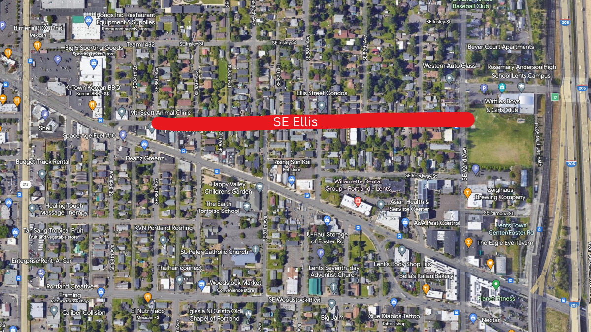


As you can see in the concept drawing above, PBOT also plans to also add new buffered bike lanes to SE 92nd between Ellis and Harold. This, combined with the advisory shoulders to the west of 92nd, will create a connection to a community center and an entrance to the I-205 path. Ellis is also a key connector for people accessing shops and other destinations along SE 82nd and Foster Road.
SW Talbot Road from SW Fairmount Boulevard to SW Gaston Avenue
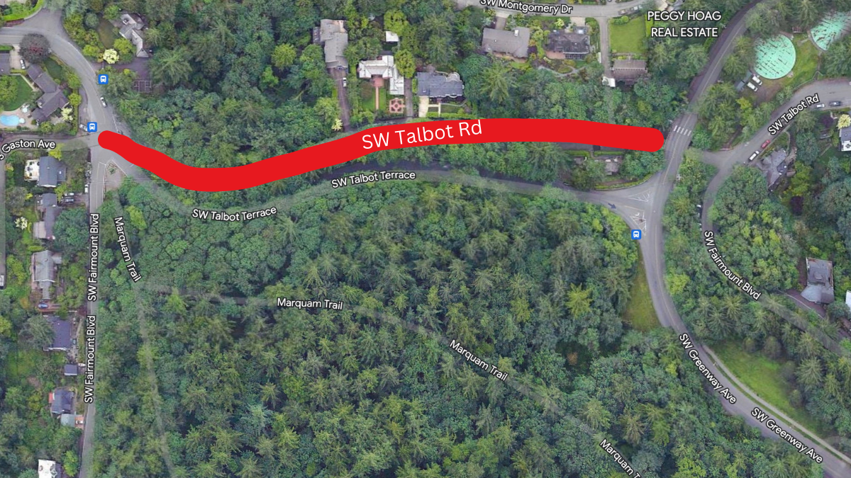
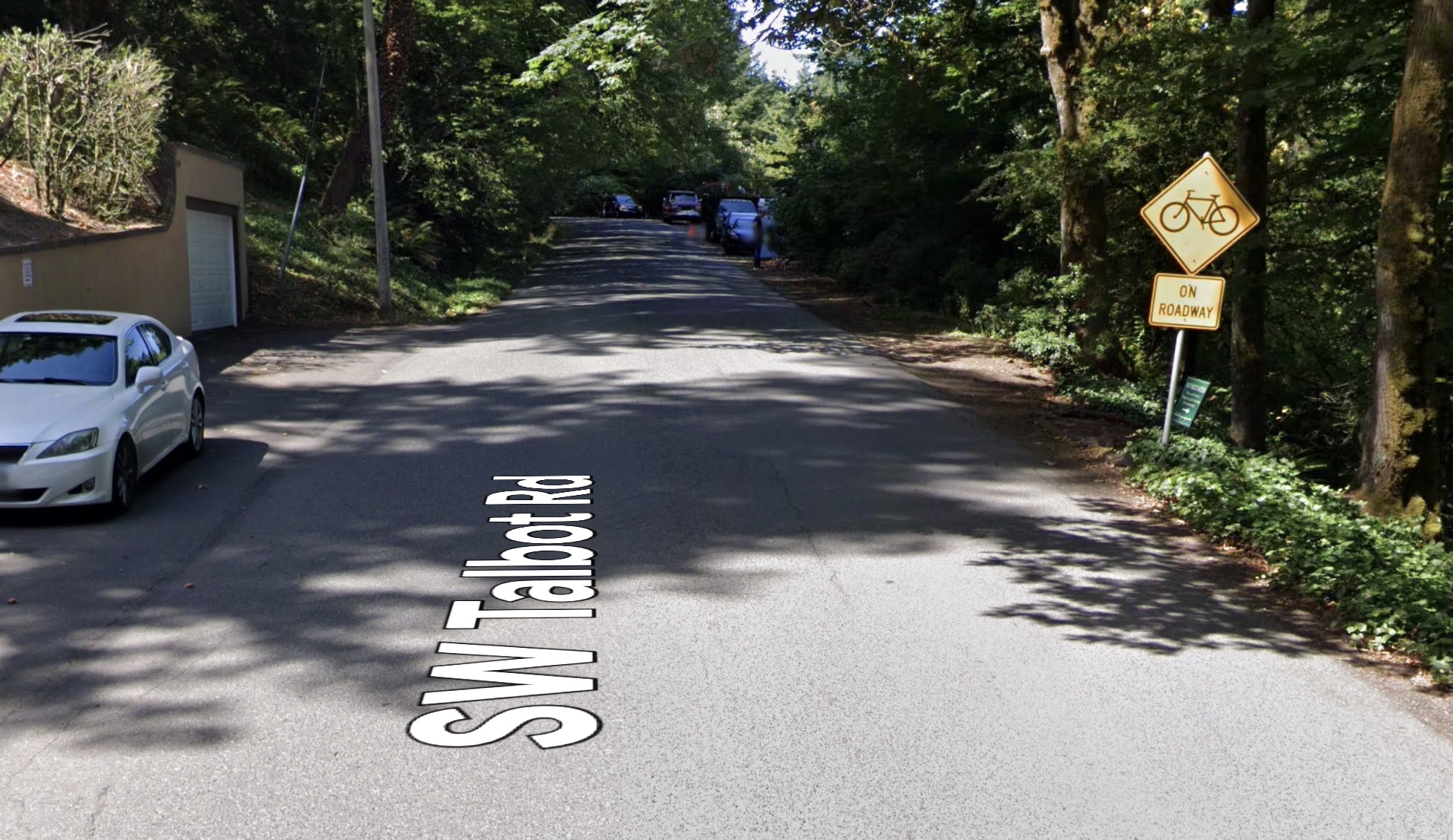
This is a small but important section of Talbot because it’s on the very popular Fairmount cycling route. Fairmount is a famous loop around Council Crest that has been a training ground (and walking loop) for Portlanders for a long time. This stretch of Talbot connects the loop and has always been a balancing act between drivers and bike riders.
You might recall that SW Talbot was on a list of candidate projects identified as part of the SW In Motion plan and we did a story in April 2021 about how advisory shoulders could unlock the potential of southwest.
SW 40th Avenue between SW Huber and SW Wilbard streets

This is just one block, but it will create a better connection between Jackson Middle School and a pedestrian walkway over I-5 that feeds directly into the Barbur Transit Center.
Advisory lanes have been used for decades in Europe to great success (they are also called edge lane roads if you’d like to Google), but they are still relatively rare in the U.S. That’s one reason why PBOT is currently collaborating with the Federal Highway Administration to share analysis of the projects.
What do you think about these locations? Are you familiar with them and do you think the new design will be helpful? Learn more at PBOT’s website.

")

Thanks for reading.
BikePortland has served this community with independent community journalism since 2005. We rely on subscriptions from readers like you to survive. Your financial support is vital in keeping this valuable resource alive and well.
Please subscribe today to strengthen and expand our work.
I’m glad to see these but it’s a shame that projects improving the streets for cyclists so rarely seem to include anything about making the intersections on those streets more safe. There are so many great safe-feeling cycleways in Portland that are chopped up by stressful or even scary intersections.
I’ve been happy with the ones on NE San Rafael. Haven’t encountered any head-on vehicle incidents yet, which is the main concern many seemed to share on here.
I noticed that PBOT is planning on green-painting the advisory lanes on the NE 53rd bridge. I have seen some confused drivers on that stretch, but I don’t know if the green paint will make it better or worse. Hopefully it encourages the traffic leaving Providence Hospital to just stay out of the neighborhood completely…
Regarding the NE 53rd project, PBOT still hasn’t taken down the obsolete southbound signage preceding the Glisan intersection.
Have you reported it? They (sometimes) get around to it relatively quickly if you report in in PDXReporter.
Yes, I spoke to the dispatcher, probably a month ago. Maybe they are waiting for when they do the painting. I have always seen a quick response when reporting potholes or clogged storm drains. Maybe signs require a different crew?
I think the painting is happening this week.
Green paint in advisory bike lanes? Feels like another mixed message from PBOT. Ugh.
I take SE Ellis to my cat’s vet and the Lents Farmers Market and think this treatment is a nice fit. It’s a real mix of cars, foot, and bike traffic, mostly slow, and will feel more welcoming to pedestrians when it’s not “walk in the car lane or walk in the mud.” Looking forward to it.
Many of the haters of this treatment completely ignore the benefit to pedestrians. This treatment has been a massive improvement for the people who have to walk along NE San Rafael. They were forced onto the soft/gravel shoulder in the past. This is much better than sharrows when you consider all road users.
It is unfortunate that they are not using buffers to separate the parking lane from the edge lane. Why create more dooring hazards when the room exists to eliminate them?
I bike the two SW locations regularly and I predict these new treatments will do absolutely diddly squat. If you are already strong and brave enough to use these streets, you don’t need these markings. But if you are afraid to ride these streets now, or you’re a mom who is afraid to let her eight-year-old ride them, then these treatments will do diddly squat to convince you the roads are safe for non-motorized users.
The key line in the article is this one:
PBOT is too scared to take anything away from drivers, so every project has a goal of LOOKING like it is doing something for cycling, when in fact it will do diddly squat.
Go to other US cities – Minneapolis, MN; Tulsa, OK; or Fayetteville, Arkansas, and you’ll see examples of bonafide cycling infrastructure – dedicated paths and lanes that prioritize non-motorized users. Portland is just lame.
Agree completely. The 2 SW streets function in this way already, and spending the few precious dollars we get for SW on this meaningless stuff is ridiculous. These streets essentially function as advisory shoulders now, and pavement markings and signs won’t change anything. Why not spend the money on critical missing links on major routes like Terwilliger where there would be immediate and tangible benefit?
On narrow steep SW roads without sidewalks, it can be scary navigating these streets by foot or bike. You always have to be cautious which side of the road you are walking on so you aren’t standing on the inside of a blind corner.SW Talbot https://www.google.com/maps/@45.5010024,-122.710483,3a,75y,100.72h,77.61t/data=!3m7!1e1!3m5!1sDqqzfkevR01jU3Ag8wFi2g!2e0!6shttps:%2F%2Fstreetviewpixels-pa.googleapis.com%2Fv1%2Fthumbnail%3Fpanoid%3DDqqzfkevR01jU3Ag8wFi2g%26cb_client%3Dmaps_sv.tactile.gps%26w%3D203%26h%3D100%26yaw%3D42.403873%26pitch%3D0%26thumbfov%3D100!7i16384!8i8192
There are definitiley a lot of streets in SW that act as shared streets, but the ones that have poorly light blind corners are not one of them.
This treatment is only marginally helpful for cyclists, but it is very helpful for pedestrians, especially if blind corners are involved. I think these will be very good for the safety of walkers on these SW streets. Visit NE San Rafael on a weekend afternoon, and you’ll see mothers with baby strollers, kids riding bikes, etc. These were things I very rarely saw before the treatment, and now they are much more common. Obviously, fully-developed streets with sidewalks should be built, but this is a very cost-effective step in the right direction.
One thing I appreciate about these–if I’m remembering various laws correctly–is that these create a much better situation legally for pedestrians.
I think people who’ve commented that some streets these are proposed for already function as advisory lanes, or that these won’t make any difference for people biking, may be correct.
A person biking already has the right to ride along the right side of the street without these. So having these added to a street doesn’t create a remarkable change for people biking.
BUT a person walking, as I recall, doesn’t have a right to walk in a traffic lane if there is a shoulder available. With these advisory lanes, that person now has a legal right (I hope!) to walk on the pavement in the street that used to be a traffic lane, even if there’s a shoulder available. So the pedestrian is no longer required to walk in the dirt or mud.
Also, before these new markings, if there’s no shoulder available, pedestrians are allowed to walk on the street paving in the traffic lane, but I believe they’re required to walk facing traffic, which sometimes is the most dangerous side, depending on blind corners, etc.
With these markings, I’m assuming (does anybody know?) that pedestrians may always walk on either side of the street, facing traffic or not.
So I appreciate that these mean I can always walk on the street pavement if I want to, even if there’s a shoulder, and not having it sometimes be a privilege granted to me by a driver. I also appreciate that if a driver hits me, it’s much more likely legally that I had a right to be walking where I was, which puts me in a much better position for getting insurance payments, etc.
The Ellis Street treatment is such a disappointment. It’s an anomaly in Lents in that it doesn’t have sidewalks – and it’s not going to anytime soon. In the first round of “East Portland in Motion,” sidewalks on Ellis got de-prioritized because other EPo advocates saw Lents as “Well, it’s in an urban renewal district, so they can use urban renewal funding for that project.” But that wasn’t part of the urban renewal plan, and PDC wasn’t really doing basic infrastructure at the time, so that never got funded.
I remember standing on that street with the late Nick Fish in 2012 and other community advocates as we talked about the need for sidewalks there. The city’s policy, instead, seems to be “As properties redevelop, let them build the sidewalks.” In the meantime, when I was walking my kid to preschool, I was pushing a stroller in the gravel.
I know others have heard this on San Rafael but I don’t trust drivers to actually obey the rules here. There are enough drivers who view speed bumps as an opportunity to test their tires’ ability to get traction in the gravel next to the speed bumps that… it’s just disappointing to see the half-measure.
Sidewalks on Ellis should have been funded a decade ago. A bus route, a busy street, a town center – it’s basic infrastructure.
Keep in mind that Advisory Lanes are experimental and that PBOT filed a request to experiment with the Federal Highway Administration over a year ago, that is why PBOT is collecting data at the sites.
I’ve been a regular at the Talbot location for over 20 years and it strikes me as an excellent site to experiment. On a sunny weekend, it is crowded with cyclists and pedestrians of all ages, either using the Fairmount loop or on the way up to Council Crest. It functions very much like a shared street.
On weekday AM peak traffic, however, the situation is quite different. This segment is used by car drivers as part of the Hwy-26 — Sylvan — Humphrey — Talbot — Fairmount — Marquam Hill Rd — Gibbs route to OHSU. This can be fast, impatient traffic, aided by the fact that PBOT has maintained a 25 mph speed posting on these residential streets, and there is a “Congestion Ahead” sign on Hwy-26 that encourages drivers to take the Sylvan exit.
So let the experiment begin, this is a good location to start. As the Advisory Shoulder project site states:
I think advisory lanes could be a big help on many low-traffic SW streets which are never, ever going to get a sidewalk.