
The folks working on a new Interstate Bridge and expansion of I-5 between Portland and Vancouver released new visualizations yesterday, including our best view yet of the potential new bike path.
The new drawings were released at a meeting of the Executive Steering Group, one of several committees formed to garner feedback on the (estimated) $6-7.5 billion Interstate Bridge Replacement Program. The ESG is made up of agency leaders and elected officials from Portland and southwest Washington. ESG members have already adopted a set of desired outcomes for the future bicycle and pedestrian facilities. Among them are that the new bikeway must “feel safe” and be “separated from moving vehicles” and that the path environment is “visible and connected.” They’ve also expressed a desire for bikeways to be “high quality,” “convenient,” and to “connect to important destinations.”
The ESG and IBRP team are currently finalizing their Draft Supplemental Environmental Impact Statement (Draft SEIS), which is due out later this spring.

IBRP Administrator Greg Johnson presented the visualizations at the meeting (where he also said they’re working on new videos that will explain how bicycle riders and walkers will make their way through the corridor). Johnson stressed that the drawings shown yesterday are not final and are, “Not for decision-making or narrowing options.” “These are just to give perspective on the size of the bridge as related to, if you’re standing on the ground on Hayden Island or on the Vancouver Waterfront.”
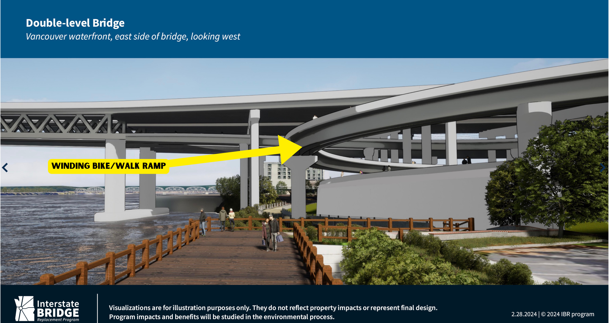
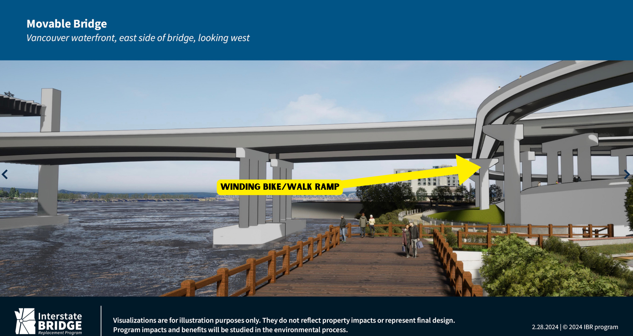
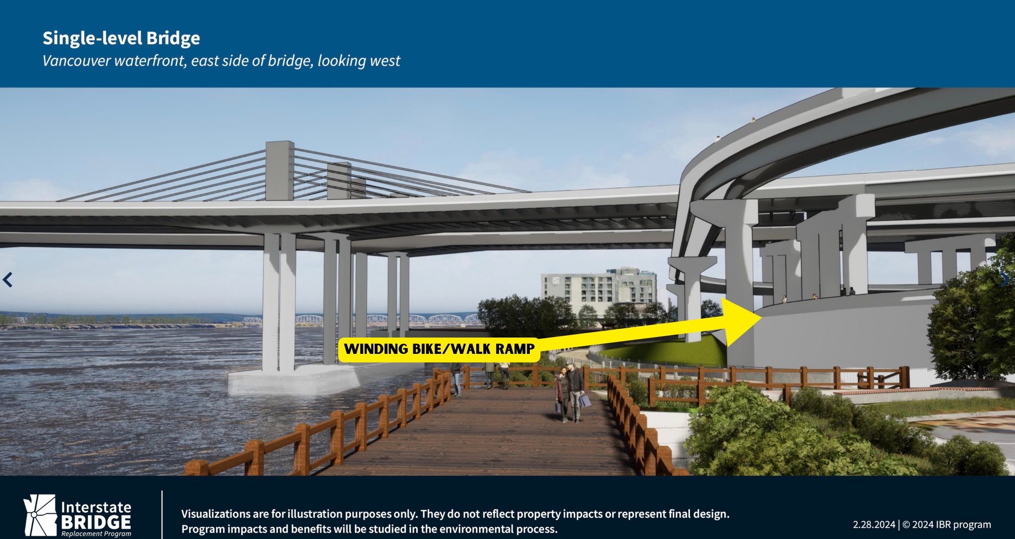
The IBRP released 12 visuals in total — three for each possible bridge option currently being analyzed in the Draft SEIS: single level, movable span, and double-level.
As he shared the slides, Johnson acknowledged, “This [bridge] is going to be a bigger bridge than currently exists.” “And this will have impacts on Hayden Island, but we think there will also be very positive impacts by reconnecting the island and providing access from Tomahawk Drive from east to west and by making a walkable community on Hayden Island.”
For the visual of the bike path specifically, Johnson said, “We haven’t determined the full width of what what this active transportation pathway would look like.”
See all the drawings below:
Hayden Island West Side


Hayden Island East Side


Vancouver Waterfront West Side


Vancouver Waterfront East Side
Note the spiral bike path in these drawings. The ramp to connect to the bridge for non-drivers will be very long and circuitous because it must reach a height of 116-feet and have a maximum slope of 4.5%.
While it’s interesting to see more details about what the future bridge might look like, I can’t help but wonder why none of the new visualizations offer us a look at any of the seven new interchanges or new frontage roads, or a detailed view of what it will look like to drive on the five miles of wider freeways. The team of PR consultants and agency leaders behind this megaproject, which has $1 billion commitments from Oregon and Washington and recently won a $600 million grant from the US Department of Transportation, have a long record of hiding the true nature and scope of this project. Almost all the IBRP public communications focus on “bridge replacement” when the fact is only about $500 million of the project’s $6 to $7.5 billion estimated cost will be for the bridge.
The less popular and more controversial aspects of this project like the additional freeway lanes and interchange ramps that will incentivize single-occupancy car use, lower the quality-of-life for everyone in the region, and were recently called out as being indicative of a “climate time bomb” by advocacy group Transportation For America, are rarely shown.
In a public comment period at the end of the meeting, persistent IBRP critic and retired infrastructure expert Bob Ortblad had a warning for ESG members. “This group should remember the history of the Embarcadero Freeway and the Alaskan Way Viaduct and how they despoiled their waterfront. Imagine if both of those were build side-by-side, they would equal the width of each of the two IBR bridge approaches on Vancouver and Hayden Island.
If these approaches are built, our children will tear them down.”


Thanks for reading.
BikePortland has served this community with independent community journalism since 2005. We rely on subscriptions from readers like you to survive. Your financial support is vital in keeping this valuable resource alive and well.
Please subscribe today to strengthen and expand our work.
Question for people more knowledgable about stuff like this: what are the remaining avenues available to stopping/scaling back this project? Is it past the point of no return?
in some ways it’s too big to be killed and in some ways it’s so big it might “collapse under its own weight” to use the phrase a knowledgeable activist just shared with me recently.
Very few. Theoretically, either state legislature could pull the plug, but given that a significant pot of money has already been fronted from each, it’s unlikely that they’ll want to back out without severe provocation. The project is relying on the granting of a bunch of Federal money that has not yet been confirmed, so there’s room there, but the granting process the FHA uses is very opaque and wonky with little to no room for public comment and interference. If project costs balloon or the Feds come back with less money than expected, there could be political will to pull out, but also there will be a significant sunk cost mentality trying to push the project forward. For all intents and purposes, this project is happening, and it’s only the relatively minor details that are still in flux.
Sooo, I guess the best option would be to try to whip up a backlash so state legislators/Kotek get cold feet? What would be the most effective messaging for that?
There are a whole bunch of states already lining up to take Oregon’s share of certain federal highway funds because they assume Oregon will eventually cancel the project or have it cancelled by the feds. The Oregon legislature would likely cancel the project if another recession hit the state economy (which does happen from time to time.) A somewhat more likely scenario is that Republicans will control both houses and the White House and engage in partisan tricks against states that are both politically weak and utterly pro-Democrat like Oregon.
The No More Freeways coalition is a scrappy group of folks who have accomplished a lot with very little in the Portland area, and they are watching this project as well, advocating for it to be a seismic upgrade rather than a freeway expansion. Their initial focus was on the Rose Quarter expansion but they are doing a lot of work on the interstate bridge replacement too. It’s not too late! The more invested we all are and the more we let our leaders know we are watching, the more likely we are to get a sensible project rather than this boondoggle freeway expansion. So sign up/follow the No More Freeways folks to keep an eye on this.
The highway builders *want you* to think it’s inevitable. That’s simply wrong.
There’s lots still available – legislature repurposing the money or not approving billions more, Congress stopping the funding, the Feds not selecting it as a good project, lawsuits over the DEIS, total redesign.
They’re only 10-15% of the way to getting this project done.
As someone else noted, we’re now dealing with the fallacy of sunk costs – a game the highway builders want you to play, and have been playing since Robert Moses and before (“well, we spent a dime, it would be a waste of that dime to not spend a dollar more”).
It just takes political leadership and courage to stop it.
Unfortunately, nearly all those Metro councilors, state legislators, and governors who say they care about safety and climate and soforth are full of it (save Mary Nolan and a handful of others). They don’t see the political calculus where it helps them to stop this. It’s up to opponents to make that political calculus look different.
I’d love to be the first person to ride across that new bridge. Maybe we should auction off the opportunity—funds raised could go to safe route to school programs in PORTLAND and VANCOUVER.
More circuitous pathways for people walking and biking… I’d love to see a floating bridge for light rail, buses, people walking and biking that can center pivot for river traffic…
Can’t do a floating bridge- current is too strong. Nice thought though.
And the water level (even with the current dams) fluctuates by ~20 FT seasonally.
I think I like the double-decker bridge the most. It would be much more pleasant to walk/bike next to the MAX than roaring freeway traffic. The road deck would also act as a sort of giant umbrella which would be nice. I would want it to be fenced in on the sides (so there’s no risk of falling in the river when it’s windy, well lit, cleaned often, and have security cameras as well.
While I agree think the double level looks the best for cycling. Important to note the road noise you’ll get from above too. Like when you ride below I-5 on the Columbia Slough (near Delta Park).
Yes, that is the design layout our bike and ped committee (CRC) supported. It would be something like cycling on the I-405 lower deck with traffic on the upper (think about it the next time you drive it).
Or check out the I-5 bridge in Roseburg. Bike/ped facility is underneath. Dark and dreary with loud traffic and constant ker-thump, ker-thump, ker-thump from above.
I feel like the vehicle travel lane options that are level with the path would subsequently make these MUPs feel similarly to the one that goes down the middle of the 205 bridge. I personally need earplugs to traverse that without hating my bike by the end.
Yeah, a comfortable and usable bike path would make a N. Portland – Vancouver (or vice versa) bike commute much more doable. Sitting in traffic in a car sucks but at least your ears aren’t ringing after.
Noisy yes! The other design issue that long time Interstate Bridge commuters know well (but the DOTs designers forget/ overlook) is that any side running MUP SUP path will have on coming headlamps shining into cyclists eyes (if its bi directional) AND all that road debris mist (bird shit, brake dust, heavy metals, other yummy) from rain water will be pushed into riders faces…like now.
This is a disingenuous comparison.
The Embarcadero and Alaskan Way viaducts ran parallel to the waterfront. This means that they cut off the entire waterfront from use and made it unpleasant to be around for its entire length, and also difficult to get to without crossing the viaducts.
In contrast, the IBR is set to run perpendicular to the waterfront. This is much more akin to somewhere like the I-105 bridge across the Willamette in Eugene, or Riverfront Park in Salem. Both of these areas have parks that extend significantly away from the bridges along the waterfront, and both are doing just fine and are great places to recreate.
Regardless of what I think about the IBR — and I think the plan is a mix of good and bad — this comparison does not hold water and at least in my view is made in bad faith. Just like how the IBR officials are withholding the renderings of the freeway expansions farther away from the river in bad faith.
The issue with freeways isn’t the directionality, but the proximity. Watefront viaducts are very bad because they make being near the water at any point bad. This project won’t do that for the entire Columbia River, but it will do it for the Vancouver Waterfront. The current conditions are already a bit meh because of the existing bridges, and the IBR will be even closer and carrying more traffic.
So it’ll feel like the west end of the Marquam bridge. A lovely place to spend some time.
It looks to me like there will be plenty of nice covered space under all that bridge for a very large tent community. Should make Delta park even more inviting for the family than it already is.
To all of us ‘Oregonians’; and those that want to kill this project…then you really have a tool that you have not used yet or even discussed. Most of this “highway” project is to facilitate the safety issues ODOT created when they removed the historical safety shoulder on each bridge to fit a new lane(s) plus the hump’s sight lines / friction off ramps to Hayden island.
Just ignore ODOT and work with the county and city council to prepare Janzen Beach for a new post outdoor mall function. Once that land use goes away so does a lot of the safety problems (and need) for a new bridge. This might then fit your goals plus do the seismic retro fitting…especially now with the draw bridge (aka ‘I-5 Stop Light’) back in the new design.
I want to see the visualizations of the view from the Vancouver Waterfront looking toward downtown Vancouver and what it will look like from closer to Downtown. Similarly, what will it look like from the developable areas on Hayden Island west of the bridge.? These views are (or course) cherry-picked to provide the best possible views (like the framing of Mt Hood from the Vancouver waterfront). Don’t fault them on that–but let’s have full transparency and see all the views so we know what we’re buying.
This is deception from a state agency that hides the negative realities of this project. We are fully capable of producing realistic renderings of what these facilities would actually look and sound like. The state legislator should demand a realistic picture of what they are wasting a ton of state resources on; and what will negatively impact the transportation environment and regional development for the next century.
Good points about the lessons of the Embarcadero / Alaska Way Viaducts cutting off the waterfronts: Few Vancouver residents (and fewer Portlanders) know that Vancouver’s core downtown extended south of 5th Street to the water’s edge before the interstate and state ramps covered it up.
And it is sad that the IBR planners are proposing to bring more park and rides in the lower portion of downtown vs facilitating less auto trips.
How very lucky we are that they’ll be aiming for a bike/ped lane that is “separated from moving vehicles”… on a freeway project. Really high-level work, there.
Honestly, considering it’s ODOT, I’m pleasantly surprised.
Keep in mind that ODOT has a history of scaling back and cutting non car/ truck infrastructure on projects. This is a picture of the absolute best that ODOT can imagine to help sell this as “multimodal.”
When I saw that very wide bike lane, my first instinct was to think:
They will convert it into a car or bus lane, “when needed.”
Waiting for a grumpy Vehicular Cyclist to claim preference for sharrows on the outer lanes so the mandatory sidepath law isn’t triggered.
This bridge will be far worse for walking and it won’t even be close. The current walk from Vancouver to Hayden Island isn’t exactly nice, but almost all of it is spent walking over the river itself – something that can’t really be avoided no matter the bridge design. Since the current bridges are low, they interface reasonably well with the rest of the world if you aren’t in a car. Walking up another 100 feet (10 stories!) on a long winding path will outweigh any positive that comes from a wider path. But naturally, no one who works on this project thinks for even a second about the practicalities of walking from Vancouver to Hayden Island. It’s all just about checking a box at best.
It’s less clear for cycling, but given the spiral ramp designs and the elevation changes it feels like it won’t be a huge improvement. Though it probably will be just based on how narrow the path is now (which is a bigger deal on bike than on foot in my estimation).
But I dunno, feels to me like the best solution is still a tunnel and retaining the existing bridges for transit and walking/cycling. But then ODOT would maybe still have to spend a few hundred thousand dollars a year on an “outdated” lift bridge. The horror!
Are you familiar with the Purple People Bridge in Cincinnati? Pretty fantastic thing that attracts a lot of community activity (you can even rent it out for events). It also connects two pretty great waterfront park areas with dining, community spaces, shopping, and entertainment options.
I’d love an IBR solution that lets us reimagine the whole Oregon side to be a destination for people desiring something besides tax-free big box shopping. Maybe keep one of the existing spans for local car traffic and light rail, and pedestrianize the other.
The problem for us is that the Hayden Island side of the bridge is not a destination I’d want to walk or ride to anyway (in it’s current state). Little Conejo, Esther Short, and the Couve waterfront are all more compelling destinations than Taco Bell and the Jantzen Parking Sea.
Andrew S…yes please bring all of your Oregon greenbacks to Vancouver! In addition, don’t forget bike friendly places like Niche Wine (new location) and classics like the Kiggins movie house.
Yes! Such an iconic name and it gets bonus points for originally being a rail bridge too. I really love Cincinnati, I think it’s such an underrated city.
Definitely agree with Hayden Island being not a destination. Last time I walked between Vancouver and Hayden Island the worst part was easily navigating the off ramps on Hayden Island and finding my way to the bus stop. So many missing sidewalks, closed crosswalks, and otherwise inhospitable pedestrian accommodations. It drives me absolutely crazy that the IBR and our state DOTs talk about this project as if it will improve walking conditions on Hayden Island. It’s just so obvious that they’ve never bothered to actually walk the current conditions and considered what works now and what doesn’t.
So to climb 116’ at a 4.5% grade; you need 2577’ of path! That’s a long ways to go…
I think this is how the maths work, been a minute:
(1/grade)*rise=run
(1/.045)*116=2577
So if it’s a 4% grade, that’s 2900’, and so on.
I’m not sure which hill in Portland that equates to, but I’d be interested in learning, and riding it. I’m guessing it’s a workout for the average person just casually trying to ride to work. Anyone got a local Strava/gps segment that equals that grade & distance?
Riverview Cemetery from the entrance to just past the first switchback is about right: 128 feet in half a mile.
I believe Tilikum crossing is close to the same grade.
Yes, but Tilikum is half the distance and elevation. I think a good comparison is going up the hill on Harrison from Ladd’s Circle to SE 30th. Not completely out of the question, but I know some people choose the Clinton Greenway over Harrison/Lincoln specifically to avoid that hill.
Not completely out of the question, but a larger hill than most people would be willing to do, especially considering that most river crossing trips are not one-way.
Hey that’s a good comparative route. .6mile, 105’, and I’ve biked that a ton. Yeah that would suck daily! E-bikes would help equalize that but we shouldn’t assume all cyclists will have one.
Route:
https://maps.app.goo.gl/PRba9bwScuzJMECu8?g_st=ic
I think if you look at the actual area with the incline Tilikum is less than a quarter of 2500′. So 4 or 5 Tilikums to get to the top.
Is it an accident that IBR renders don’t give us the zoomed out view of the whole project?
Yeah, I don’t think so either.
Did anyone else notice that in all of the images that the fixed deck of the moveable bridge, which seems to be lift span, is the same height as the single level bridge? For that matter, the lower deck of the double level bridge also appears to be at that same height. It seems to me that they are not portraying the true heights of either the single of the double level bridges.
I noticed that too! I came up with a few questionable rationalizations for why that could be, but ultimately, I think these perspectives are not a very good representation of what this thing would look like in real life.
So, the Marquam bridge is (per Wikipedia) 130′ above the river, pretty similar to where this bridge would be. Here’s a Google Streetview of the Marquam from the esplanade just to give their perspectives some context:
Google – Google Maps
Pity none of the visuals include indication of air quality. Who doesn’t enjoy biking, running, or walking adjacent to a whole bunch of perpetual pollution machines? Oh, I guess any one who breathes doesn’t.
It is mentioned elsewhere in these comments that the similar situation on the I-205 bridge is a profoundly horrible cycling experience. Yup!
This whole project is so depressing! The ugliest drawings in the world. So many competing interests. It can’t be too high, nor too low. The circuitous bike/ped entry and exit points that look like we’ll have to walk/pedal farther than we do now to get north or south. The decimation of Hayden island with more lanes and concrete. The huge financial, visual, aural and health costs of it all.
I think they should just rip it all out and go back to a ferry. Since Oregon will be going to year round standard time and Washington won’t, you’ll already be an hour late, or will have time to burn, depending on direction of travel.