“This is a big moment for the Pacific Northwest,” is how Oregon Governor Tina Kotek characterized news announced Friday that the Interstate Bridge Replacement project (IBR) won a $600 million Mega Grant from the Biden administration’s infrastructure bill. These funds are in addition to $1 billion already authorized by the legislatures of Oregon and Washington.
You know a project is expensive when a $600 million grant is just 8% of the total estimated project cost — which in this case could be as much as $7.5 billion.
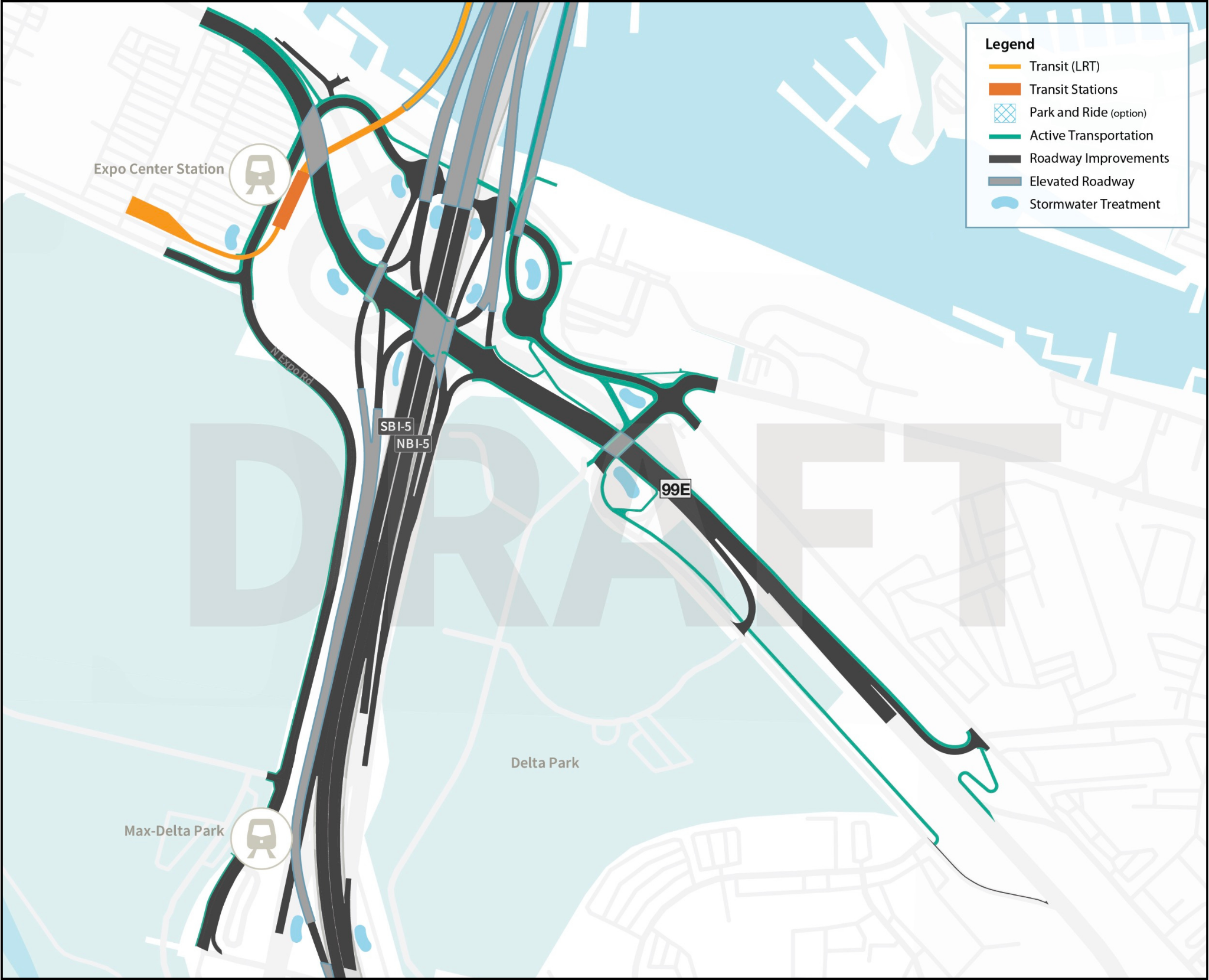
The IBR is a freeway expansion project that will add lanes to nearly five miles of I-5, enlarge seven interchanges, extend MAX light rail into Vancouver, create new paths for walking and biking, and more.
Despite critics that say the bridge will promote sprawl and increase vehicle miles traveled (VMT), Governor Kotek was one of many local elected officials that welcomed the grant. “This project will help advance our goal of reducing emissions through a modern, multimodal bridge and will provide an infusion of federal funds to our region that will support local jobs and broader workforce opportunities,” the Governor said in a prepared statement.
Even with $2.5 billion already committed to this mega-project, the IBR is still looking for another $2.5 billion in federal grants and both states plan to use toll revenue to make the budget math work out.
News of the grant came out just a day after a scathing article on the project was published by Streetsblog USA. That story relied on economic analysis from noted project critic and No More Freeways Co-founder Joe Cortright. Cortright’s group urged the FHWA to “carefully examine the benefit-cost ratio” of the project and to, “reject the proposes application for federal funds.” The thrust of Cortright’s concern is that the state DOTs from both sides of the river are using the need to replace the Interstate Bridge as an excuse to widen five miles of freeway and expand seven interchanges.
“Most of the cost of this project comes from a freeway widening that doesn’t produce many, if any, benefits,” Cortright told Streetsblog.
Supporters of the project point to the extension of MAX light rail into Vancouver and updated biking and walking paths as proof that the IBR will be a net positive. Many believe that the project will relieve congestion and that cars emit less greenhouse gas emissions when traveling at a steady speed versus being stopped in traffic.
When a precursor project to the IBR was proposed a decade ago, it died (after hundreds of millions were spent on planning) when right-leaning Washington lawmakers balked at the sticker price. So far anti-project voices haven’t emerged in a big way; but as the project gets closer to the finish line, it’s likely they’ll get louder. Whether it’s the use of tolls, presence of light rail, or the sheer cost of the project, we’re likely to see some politicians get nervous.
But with each new funding commitment, the IBR gains momentum. And as we’ve learned over the years these mega-projects rely on momentum to help roll over any speed bumps that might pop up along the way.
Upon hearing the news last week, noted right-wing media personality Lars Larson called the project a “fraud on the taxpayers” and wrote on his blog that the new bridge design isn’t big enough and spends too much on light rail. “We should just call this thing, ‘Boondoggle Bridge 2 point oh’,” Larson wrote.


Thanks for reading.
BikePortland has served this community with independent community journalism since 2005. We rely on subscriptions from readers like you to survive. Your financial support is vital in keeping this valuable resource alive and well.
Please subscribe today to strengthen and expand our work.
This is not specifically a critique of the language used in this article, but I wish it was possible to have more accurate framing on what this project is. It’s pretty clear that it’s a freeway widening/expansion project, and yet the project and associated “regular” news coverage keep calling it a “replacement”
Combined with the Boone Bridge replacement doing the same thing, adding “auxiliary” lanes and then green washing it with a “potential” bike path, it makes me wonder when we’ll have people stomping for more lanes of I5 going through downtown Portland itself. https://www.oregon.gov/odot/projects/pages/project-details.aspx?project=i5-Boone-Bridge-Study
You and me both! I hate the misleading way they frame these projects. It’s done on purpose and I think DOTs need to be held accountable for their dishonesty. Everything the IBR has put out is about this being a bridge project. They know replacing a bridge is very popular… yet they seem to hide all the facts about the 7 interchanges and all the new lanes. It’s maddening and folks like No More Freeways have been working hard to expose more facts about the projects.
Replacing the bridge with accommodations for light rail or bus rapid transit and providing clearance for barges without a lift span does, in fact, require some of the interchanges to be rebuilt. Add in provisions for bicyclists and pedestrians to ensure compliance with the ADA, mitigation for harm done to indigenous communities, mitigation for wetlands and wildlife, and the project just keeps getting more expensive.
To use a cycling analogy, when you get to the point of excessive chain wear (as in, you didn’t replace it soon enough), you end up replacing the freehub and the chainrings. You wouldn’t be happy just replacing the chain.
I think that’s mostly fair, however the part that they’re specifically being misleading about is that the lane widths, number of lanes, and overall road deck space, is being massively increased (doubled?), and it’s not being accurately called an expansion.
If you ride a single speed you barely have to change the chain.
Your analogy leads me to think you’ve also been misled. This “bridge” project extends north another 2.3 miles BEYOND the bridge, widening the freeway and expanding three additional interchanges completely unrelated to the bridge. This is what no one’s talking about and is contributing substantially to the overall project cost. You have to dig around the IBR website to even find a map of the full project area.
A more apt analogy is: oh no, my chain’s worn out. Time to buy a car.
I don’t doubt that, but that doesn’t explain why the existing bridges at E 29th and E 33rd need to be replaced with new structures.
It requires the interchanges that interface with the bridge to be rebuilt, but there’s no reason to rebuild the interchanges at WA-500, 4th Plain, and Mill plain. Those rebuilds are being driven by WashDOT and Clark County’s desires to expand the freeway through Vancouver, not by any meaningful requirements brought about by a bridge replacement. And, of course, the bridge itself is being engineered to be wider because of Washington’s desire to expand the freeway in Vancouver.
The money to replace the Mill Plain interchange was set aside as part of a 2015 transportation funding bill and was to proceed regardless of whether the I5 bridge was replaced or not. I believe that was requested by the Port of Vancouver because it is challenging to move large oversized loads (wind turbine components) onto the freeway.
Are there still plans for the SR500 interchange? I know it is on Washington’s wish list, there is no direct access from SR500 to I5 North, but didn’t think that was being pushed as part of the new project.
Last time I drove to Seattle, I was amazed that I-5 has five (?) lanes in each direction (not everywhere but in sections in north Vancouver). And they want to add more lanes??
Page 60 of the LPA (https://www.interstatebridge.org/media/vebbod4f/20220504_draft_ibr_lpa_briefing-book_remediated.pdf) lays out the 2 “auxiliary” lane scenario…which is really an additional continuous lane from the Victory/Interstate interchange all the way to Main St (north of WA-500) on the Washington side.
Reposting this comment I made earlier today, as it is more appropriate here:
As we are now in the era of IBR planning there are some new tools in the [WSDoT] toolbox for planning how well any new bi-state bike and ped facility will work; tools that we did not have, as bi-state advisory staff back in the CRC era (we asked for the bike ped delay and travel time difference impact back then but was never officially given for alternatives):
Does anyone know (and have experience) with if ODoT has similar tools in their planning and design toolbox? Or will this be a problem that needs to be fixed ASAP for a successful bi-state design process?
The federal DoT has similar national guidance that some states (like Washington) have adopted.
https://www.wsdot.wa.gov/publications/manuals/fulltext/m22-01/1510.pdf
https://ssti.us/2021/11/16/utah-and-washington-dots-measure-connectivity-across-highways-under-recent-federal-pilot-program/
Earlier today I was part of a NC statewide online meeting with 56 others about a clean energy grant that the federal EPA was pushing hard to implement – $4.3 billion nationally – and federal officials are now assuming Trump will win next November, so they are trying extra hard to get things funded and out the door before a new congress meets next December, before the Republicans can take the money away. I’m guessing your $600 million was related to that.
Related to our meeting, they gave us links to a whole bunch of new tools from both the feds and various state DOTs for analyzing projects – I’ll try to forward some of those links. (NC is a major “swing state” valuable to both parties, so we aren’t really worried about a loss of project revenue from either party.)
Good info here. T**** will take the money to “finish the wall,” which isn’t fit for purpose.
The linked pdf tool kit document is designed for NC municipalities and MPOs applying for certain types of grants. It’s a very useful guide to all kinds of basic planning tools for reducing VMT and supply easy links for other funding sources – they even cite Portland, PSU & Victoria BC examples! (You can skip the first link as it is NC-only.)
https://www.ncdot.gov/initiatives-policies/environmental/climate-change/Pages/vehicle-miles-traveled-reduction-study.aspx
Jonathan, the 2013 Washington lawmakers’ denial of funding was more than just a “price tag” issue…as they would have likely spent more for full highway expansions (without LRT etc.) statewide AND if the CRC had a “3rd Bridge” in the Vancouver zone (196th Ave).
Mainly it was more a Outside Puget Sound (Eastern + SW state) side vs Puget Sound political show / poke in the eye of reigning Democrats by the Republicans that briefly took over the legislature [due to a legislator who jumped the aisle]. If it was about money…then it was a rebellion against the funding mechanism: WA sales tax hike AND bridge user fees (tolls)…versus having everyone in the state(s) pay for it.
Why are you giving Lars publicity?
Because it seemed relevant and I wanted to. Also, I don’t really subscribe to the idea that some people are to be ignored (except for extreme cases).
Wasn’t Lars Liarson, it was state senators Ann Rivers and Don Benton!
I loved the statement that Kevin Mannix (R-Salem) put out, which mentioned cars and freight but nothing at all about bikes and peds, echoing other sentiments we hear about how bikes and peds don’t matter.
This thing is going to be such a disaster when it get built. MAX across it will be slow and infrequent. Bike/ped accommodations will be right next to ten lanes of freeway traffic with minimal protection. It will be a huge eyesore for Vancouver’s redeveloping waterfront. Highway widening associated with it will only serve to induce demand and bring more selfish, disgruntled, entitled drivers to our neighborhood streets.
Oh but traffic might get marginally better for a few years.
If it’s any compensation, the money only kicks in once the project is completed. If the project gets cancelled (and many other states are still betting it will get cancelled), then the money becomes available to other eligible projects, first in Oregon (if there are other eligible projects available), then in other states.
I concur, this was my first thought too.
If it gets built.
Or if it gets built Its current form. Hopefully some of the advocacy groups can do something to steer it in the right direction. https://nomorefreewayspdx.com/
One design for the CRC2 concludes “single-deck” (rather than double-deck) is the only sensible bridge option. River clearance is 135′ (through the central span) which exceeds Coast Guard standard of 125′ (as of 2013). Double-deck bridge river clearance is 116′ – too low. Its spans are 5-lanes northbound, 4-lanes southbound, and a 3-lane transit/ped span furthest west forming an emergency access corridor. In a major accident, MAX trains would halt, but buses could steer around stopped emergency vehicles. 5-lanes northbound is necessary because of afternoon rush hour traffic and to access SR14 east and downtown Vancouver exits located too close together. SR500 and Mill Plain interchanges can be left as is.
New access ramp designs to Hayden Island are more complicated than necessary. This CRC2 design eliminates the 3rd central underpass to make these ramps safer. The south side underpass is rebuilt and the north side underpass remains its current height. There are two exits to Hayden Island southbound – from the transit span for buses and an exit for traffic which curves west to an intersection. Truck traffic goes straight through, turn left for access to the local bridge to Expo Ctr with light rail leading to a Hayden Island surface station terminus/junction with Vancouver BRT. Access to I-5 south occurs across the local bridge at Delta Park.
Access to/from Hayden Island to/from I-5 northbound is a bit more complicated but still simpler than this official new design. Northbound exit and entrance ramps are are “woven” to eliminate the merge.
My sense of the official designs for Hayden Island is that they put development potential ahead of public safety. The simplest and safest and least expensive access ramps require more space. Representative Ann Rivers, Don Benton and Jaime Beutler did the right thing refusing to fund TERRIBLE engineering from Lynn Peterson and Kris Strickler. A federal investigation of ODOT, WsDOT, PBOT, Metro & Tri-Met is warranted. The incompetence is so glaring, corruption cannot be ruled out.
Yes per the bike ped comment, this is why – in 2007 to 2009 – I spent my staff time trying to get a covered all weather and as ‘remote as possible’ bike ped way on the under deck of the CRC (along with NEV access in the other side of the under bridge section)…based on 10+ years of cycling on the i5 and i205 facilities. [Think of cycling on the under deck of the i405.]
Regarding the MAX to VAN, it all depends, yes it may be a slower trip than the “ideal” non peak CTRAN 105…but I expect it will be faster than (and more dependable) than the 105 during peak or the CTRAN local looping thru Jansen Beach mall + transfer wait/ missed connection + MAX. [I have spent many a ‘express’ bus detour around the i5 grid lock mess or a wet and cold night transferring between transit modes when not cycling it.] Yes the MAX design could even better…if they added a ‘subway’ type facility in the city center.
The MAX connection between Vancouver and Portland is going to be very critical since Vancouver will be skipped by the future high speed rail plan – no one in a local leadership role is fighting for it (‘they’ all drive and are missing the economic impact of skipping the 3rd largest city in Western WA and second largest in ‘Greater Oregon’).
I live in Vancouver and very much do NOT want to see this go ahead! This will just fucking gut a downtown that’s starting to revive itself–is there any metric on this monstrosity as to the housing units and business square footage that will.be lost in it’s construction? Is there any way that Ctran and Tri Mer can steal the $ and use it instead?
The only clear loss I’ve seen was for park-and-ride garages in downtown Vancouver. Hopefully, those aren’t built downtown. There are several existing park-and-rides scattered around Vancouver. Commuters should be encouraged to use those and take the bus to the Vancouver MAX station.
You could make it 40 lanes wide and it still wouldn’t reduce congestion.Sure over the 5 miles it was expanded VMT would go up but when you hit that first bottleneck it would all go out the window. Saving 20 seconds to go 5 miles only to have to merge down to 2 or three lanes and with other interstates isn’t going to save most people any time.
They need to just replace the bridge and Lars has no idea what he’s talking about as per usual.
Per Wikipedia, the Glenn Jackson bridge (which is 8 lanes wide and over twice the length of the Interstate Bridge) was built for just under $170 million in 1977-1982.
Inflation calculator says $170 million in 1980 is just over $630 million today.
In a sane world, ODOT could go ahead and build a new Interstate Bridge next to the old one with the money the feds just gave them. But somehow, that’s not enough.
DOTs do not want to continue to manage and repair anything older than 20 years old…and neither Portland nor Vancouver or Multnomah County wanted an arterial bridge option (back in the CRC days, I assume this is still true as it would then be up to them to pay for its upkeep).
I’m looking forward to the bike improvements that will come with this mega project.
I guess I am too, Priscilla, but I absolutely hate the poop that comes with the rest of the project. I mean, I’m glad I can bike across the Glenn Jackson Bridge now, but it’s such a horrible experience that I don’t do it unless I absolutely have to – and the I-5 cycling experience is not much better.
I want the new I-5 bridge to provide a cycling experience that is somewhat pleasant but I have no confidence that’s a priority for anyone and I fear we’ll end up cycling five feet away from the 18-wheelers.
I’m not looking forward to having to bike 150 feet in the air and have a really long, indirect connection to downtown Vancouver. For me, it’s a downgrade.
Here is how bi-state ‘express transit’ works for much of the day on i5. (Running late to the BP social meeting.)
It would be cool if our transit had some kind of dedicated right of way so it wouldn’t get stuck behind cars and trucks. And once we get the cars and trucks out of the way, we could run some electrical wires so the transit vehicles could be zero emission without the need for batteries. And then we could use steel wheels on steel rails for lower rolling resistance, and make them longer so they could fit more people with the same driver. That would be cool.
And it has an express line that allows it to bypass stops instead of just being built like a slow local bus route.
Can we get a sidebar going for how over budget and over time IBR will take, assuming it doesn’t also get cancelled before breaking ground? In all seriousness though, brace yourselves for more of the same, and worse, as this story develops for the next ten years..
My design for the CRC2 concludes “single-deck” (rather than double-deck) is the only sensible bridge option. River clearance is 135′ (through the central span) which exceeds Coast Guard standard of 125′ (as of 2013). Double-deck bridge river clearance is 116′ – too low. Its spans are 5-lanes northbound, 4-lanes southbound, and a 3-lane transit/ped span furthest west forming an emergency access corridor. In a major accident, MAX trains would halt, but buses could steer around stopped emergency vehicles. 5-lanes northbound is necessary because of afternoon rush hour traffic and to access SR14 east and downtown Vancouver exits located too close together.
The new access ramp designs to Hayden Island are more complicated than necessary. My design eliminates the 3rd central underpass to make these ramps safer. The south side underpass is rebuilt and the north side underpass remains its current height. There are two exits to Hayden Island southbound – the transit span for buses, then an exit for traffic which curves west to an intersection. Truck traffic goes straight through, turn left for access to the local bridge to Expo Ctr with light rail leading to a Hayden Island surface station terminus/junction with Vancouver BRT. Access to I-5 south occurs across the local bridge at Delta Park.
Access to/from Hayden Island to/from I-5 northbound is a bit more complicated but still simpler than this official new design. Northbound exit and entrance ramps are are “woven” to eliminate the merge.
My sense of these official designs for Hayden Island is that they put development potential ahead of public safety. The simplest and safest and least expensive access ramps require more space. Representative Ann Rivers, Don Benton and Jaime Beutler did the right thing refusing to fund TERRIBLE engineering from Lynn Peterson and Kris Strickler. I’ll say this again: A federal investigation of ODOT, WsDOT, PBOT, Metro & Tri-Met is warranted. The incompetence is so glaring, corruption cannot be ruled out.
Yuck. That’s a lotta roadway going in. Can we request a spatially separate (on top of maybe) LRT/Bike path? For 7600 million dollars, I feel like we can do better than the I-205 sonic deathtrap that is the center bike lane there