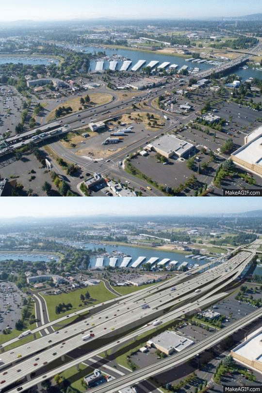
You’d think that with all the support for the Columbia River Crossing down in Salem, lawmakers and their constituents would have a good idea about what their votes — and their tax dollars — will be going toward. But for some reason, CRC and ODOT staff have hidden the project from public view. Despite spending nearly $170 million on consultants and planning thus far, detailed renderings and/or visualizations of key elements of the project are nowhere to be found.
This is not typical of other large infrastructure projects across the country and it begs the question of whether or not CRC and ODOT staff are purposefully pulling the wool over our eyes.
Advertisement
While detailed renderings of the expanded freeways and massive new interchanges along the five mile project corridor are nowhere to be found, images of the bridge, the biking and walking path, and photos of traffic backups are ubiquitous. Take a look at any recent media story about the project and you’re almost guaranteed to see that same image of the new bridge design as the lead visual.
This is a basic lack of information and public transparency. And it’s all according to plan by CRC backers. From Governor Kitzhaber on down, part of the way this project has been sold to the public and to politicians is by making everyone think it’s just a “bridge replacement project.” From lawmakers urging that “It’s time to build a bridge,” to pro-CRC media outlets calling it a “bridge project” and the recent renaming of the project itself — there has been a coordinated effort to not be transparent about the massive footprint this freeway expansion project will have.
A presentation by Kris Strickler, a former CRC staffer and consultant who’s now the project director for ODOT, given to the project’s legislative committee on February 18th, did not include one image of the freeway expansions or of the the five new interchanges coming with the project. Of the 17 images and graphics that appeared in Strickler’s 20-slide presentation (PDF), nine of them were of the bridge. There were no images at all of the new freeway lanes.
This is how ODOT wants lawmakers to remember this project…
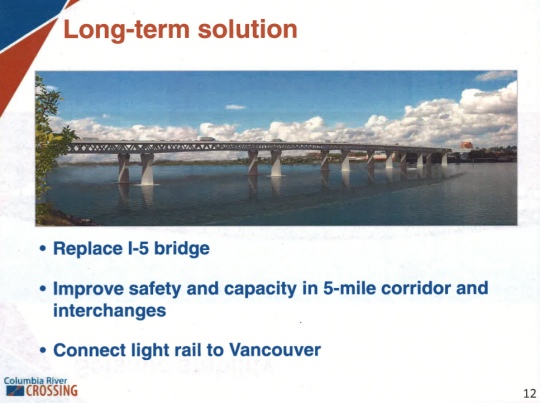
While the new bridge is always put in the spotlight, the fact is the bridges are only 30% of the total project cost. 41% of the costs will go toward new/rebuilt interchanges. “We might as well call it the ‘on-ramp replacement project’,” quips a group of project critics working to debunk many of the project’s myths.
Concerned about this lack of good project imagery, I asked friends via Twitter to try something: Visit the CRC website and try to find renderings, flyovers, or any type of detailed images of the freeway lanes or interchanges. They came up empty.
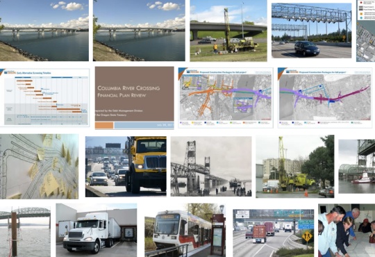
One guy did a Google Image search of the project website and the results were telling: Not one detailed graphic or image of the proposed lane expansions or interchanges.
After I dug around on the site and couldn’t find anything good, I contacted CRC project staff. I emailed CRC Communications staffer Mandy Putney the following question:
“I’m curious about what the initial phase project looks like throughout its entire, five-mile length. In other words, the only visuals/renderings I’ve seen are the shot of the bridge span that appears in many news articles. Do you have any up-to-date visualizations, renderings, animations, videos, and so on that would give the public a clear idea of what they are paying for?”
“When you look at it in comparison to what other DOTs put out there, it’s obvious the omissions the CRC is making in its publicity materials. It’s a project that doesn’t want to be seen for what it is.”
— Spencer Boomhower, graphic designer
In response, Putney emailed me a link to a 45-page PDF titled, Design Guidance for the Columbia River Crossing Project (PDF) which was created by the project’s Urban Design Advisory Group. That report was full of non-detailed, cartoonish sketches of various parts of the project. The only real concept drawing (used as the lead photo in this story) was buried in the appendix in a handout created for Hayden Island residents.
When I followed up with Putney to ask whether there was a more easily accessible place on the website where the public could find detailed conceptual renderings of the project, she sent me more PDFs. Two of them were of the project’s Final Environmental Impact Statement (which 99.9% of the public will never look at) and the other was a non-detailed graphic of the entire project footprint (not what I was asking for).
Advertisement
My exchange with Putney confirmed my hunch: There are no easily accessible images or visual aids available to the public that would give them a good idea of what the CRC has in store.
And it turns out I’m not the only one who’s been concerned about this.
A 2010 article in The Columbian newspaper, New bridge will cast a long shadow over Vancouver, is the only major media story I could find about this issue.
The story details concerns from Vancouver civic leaders about a lack of detailed images about how the project’s footprint will impact downtown Vancouver. Here’s an excerpt:
Elson Strahan, president of the nonprofit Fort Vancouver National Trust… worries that the new bridge will offer the same unappealing view from downtown Vancouver as Portland’s Marquam Bridge has from the parking lot of the Oregon Museum of Science and Industry.
“When you build this structure, what will you be looking at?” he said.
No one is exactly sure.
Dick Pokornowski, a former Vancouver city councilor who served on the crossing’s urban design advisory group, said the group never saw street-level renderings.
“We had requested different computer designs of how the bridge would look,” he said. “And some of that stuff they said they couldn’t do because it would cost too much.”
This would be the largest public works project in the history of Oregon. The excuse that good imagery cannot be made available because project staff — who have already burned about $170 million — can’t afford it seems absurd.
The only thing planners provided Pokornowski were photo simulations “from a bird’s eye view, which tend to diminish the looming effect people would experience from the ground.” The story reported that Kevin Peterson, a Vancouver architect doesn’t think the lack of realistic imagery is a coincidence.
Portlander Spencer Boomhower is a graphic design expert. His animations of the Idaho Stop law and the Common Sense Alternative (a CRC option that critics say was never given a fair shake) have helped tens of thousand of people better understand those complicated topics.
Boomhower at one time considered putting together a similar animation of the CRC; but he couldn’t even get the images he needed to make it happen. He thinks the CRC staff and project backers are purposefully preventing the public from understanding the project. “When you look at it in comparison to what other DOTs put out there, it’s obvious the omissions the CRC is making in its publicity materials. It’s a project that doesn’t want to be seen for what it is.”
Boomhower shared the video below which was created by the Wisconsin DOT to give the public a detailed and realistic view of a major highway project:
Boomhower said creating visuals like the video above for major projects is usually “standard practice.”
Noted project critic and Portland-based economist Joe Cortright has also expressed concern at the lack of realistic visualizations being available by the CRC project. In his official comments on the Final Environmental Impact Statement, Cortright wrote: “Almost nothing in the Final Environmental Impact Statement reveals how this massive structure will affect the views and light of human beings standing on the ground anywhere near the structure.”
Cortright says the project’s lack of visual representations is in violation of the National Environmental Policy Act. Here’s more from Cortright’s comment:
“The project’s visual impact technical report contains only a handful of computer simulated images of the bridge. Nearly all of them are taken from distant points floating in the air (where no human being will ever actually perceive the structure)…
The decision to present such a limited and artificial set of perspectives represents a conscious attempt on the part of the sponsoring agencies to conceal the project’s visual impacts. It is a decades-old gambit: Robert Moses used the same scheme to try to sell a proposed Brooklyn-Battery Bridge in the 1930s. He concealed the fact that the bridge would have obliterated views from the ground (and the lower ten stories of buildings) in Lower Manhattan, by showing the bridge as it might be viewed, in the words of Robert Caro “by a high flying and myopic pigeon.” (Caro, Robert. 1976. The Power Broker. Page 464). It was exactly this kind of chicanery that NEPA [National Environmental Policy Act] was designed to prevent.”
If this project is as wonderful as its proponents proclaim it to be; why don’t they share more of it and let us all know what we have to look forward to?
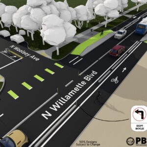
Maybe because they know images like the ones below (which can be found in that report by the project’s Urban Design Advisory Group and on the website of a CRC project consultant), would not be nearly as popular or easy to sell as simply “a new bridge.”
Whether you’re for or against this project, if we are being asked to support this massive investment in scarce transportation funds, don’t you think we deserve to know what we’re paying for? And what’s most troubling is that 45 members of the Oregon House voted yes on a project they’ve never even laid eyes on.
Even with HB 2800 passing the House, anti-CRC forces have not given up. There’s a house party in northeast Portland being planned tonight. Bike Walk Vote and Coalition for a Livable Future are hosting a letter writing campaign and a fundraiser to keep the grassroots opposition going. Full details on Facebook.


Thanks for reading.
BikePortland has served this community with independent community journalism since 2005. We rely on subscriptions from readers like you to survive. Your financial support is vital in keeping this valuable resource alive and well.
Please subscribe today to strengthen and expand our work.
Of course they’re hiding the designs from the public, just like they’ve rejected public testimony and the factual traffic data that shows the need for a new bridge (let alone a new freeway) isn’t there. CRC supporters are pure cowards.
One thing to keep in mind, the Golden Gate Bridge cost $35 million back when it was built. Which is about $600 million today. (http://reason.com/blog/2012/07/17/obamas-shaggy-dog-story-about-the-golden ) We’ve already spent nearly a third that amount with almost literally nothing to show for it except massive debt and rich lawyers and politicians.
Interesting fact. The CRC will cost more than 40 times the amount Apple is investing in expanding its manufacturing in the US. Which do you think will create more permanent jobs?
What struck me is that Tom Markgraf, a local political consultant, has received almost $1 million dollars for his work on the CRC. Patricia McCaig, another political consultant, kicks the total spent on political operatives over $1 million. The vote at the legislature confirms they are good at their work.
on the CRC site I just saw the archive footage of the Interstate bridge opening and realized that the sidewalks used to be wide and on the INSIDE of the bridge structure instead of narrow and tacked onto the outside… I also learned that there used to be a toll booth plaza…
Draft Concepts – Locally Preferred Alternative
http://www.columbiarivercrossing.com/FileLibrary/GraphicsandPhotos/DraftConcepts_LPA.pdf
Hey Spiffy, Thanks for the PDF. Not only are those images buried in a planning document and not available to the public in a more easily accessible form on the web; but they are distant, off-angle views that do not give the public a visceral sense of what to expect. For $170 million in planning of a $3.4 billion project, I think it’s not asking too much to see some high-quality animations and/or visualizations of the project.
Also, those PDFs are five years old.
Looking at that old doc from five years ago, you have to wonder if that was about the point they started saying to themselves: you know, producing realistic renderings of this thing probably isn’t going to do us any favors.
Old as it is, it’s still a great source for making animated gifs:
Rather than an animated GIF, can you merge slides 7 & 8 such that the old bridge is in front of the new bridge within a single image? Seems like it would give a nice sense of scale as to how high & wide the new bridge it compared to what we have. Thanks!
In this image you’ll notice a huge collection of buildings to the right (West) of the Jantzen Beach landing that miraculously turns into a grassy slope – park perhaps. Being curious what large landowner might get torn down, and how, I went to google maps to find out what that was. Turns out, it’s now the burned out shell of the Thunderbird Hotel (remember that: http://www.oregonlive.com/portland/index.ssf/2012/12/police_offer_1000_to_solve_thu.html )
Just a few more months/years and their tax woes would have been wiped clean when the state had to pay “fair market value” to acquire the land!?
I’ll just put these here:
http://www.columbian.com/news/2012/apr/11/thunderbird-hotel-on-jantzen-beach-in-limbo/
http://www.oregonlive.com/window-shop/index.ssf/2012/12/large_retail_development_plann.html
it’s definitely old and buried… but it was all I could find of the other interchanges… like others I’d love to see some onlooker shots from the ground…
Wow, what those slides make clear is what a *RAW* deal Vancouver is getting out of this deal. The people of Vancouver should be kicking and screaming about Portland jamming its new highway right through their front door.
Anyone know the percentage of Vancouverites that work in Portland (and thus stand to benefit) vs. commute exclusively on the WA side of the river (and thus get a mega-highway jammed through their front door with nothing to show for it)?
Actually from those pictures it doesn’t look as bad as it will be. First those are from the lower height (95 foot?) bridge and those interchanges have to be made bigger to get people up to the higher span to hit 116 feet.
More curious is that none of those pictures show anything about how the lane expansion and interchange look going from Hwy 14 to Hwy 500.
Good work on this article, let’s hope it goes viral. I see a Pulitzer prize in your future…
Thanks for continuing reporting on the CRC. This latest vote does little to clarify where this whole thing is going, nor does the money spent thus far seem to have been used to design anything definitive.
I guess this community is just going to disappear?
http://tinyurl.com/bepmlo6
Please also call your Senator. Calls are great because they are faster than writing but more meaningful to the office. A one minute call could save you billions.
http://bit.ly/findmylawmaker
Suggest call is simple:
“Hello, my name is ___ and I’m a constituent.
I’m concerned about the CRC because of ___.
Will the Senator join me in opposing the CRC?
Thankyou, Have a good day. Good bye.”
Please ask friends to do the same. Massive grassroots pressure is the only thing that can slow this down.
Great article and coverage .
Whatever happened to the lawsuits against the CRC?
Also, Is there any way to force a public vote on this issue, such as through a petition?
No referendum will be possible with HB 2800, as it has an “emergency” clause that prohibits the public from gathering signatures to put it to a statewide vote. Democracy in action!
OMG, WTF, CRC! For real, Hart?!
that could probably be challenged in court, IMO the ’emergency’ designation is used way too much in state legislation and for city ordinances, more as a political maneuver than as a matter of a real emergency.
Thanks Jonathan for your continued reporting on the CRC. I was looking at the animated GIF of the Jantzen Beach changes last week when 3 separate people in my office came up and looked over my shoulder and asked what it was. None of them had any idea that this was part of the CRC. I have looked on the CRC website in the past to get better visuals of the project and how it will change the current landscape and was frustrated by the lack of clear information. Thanks again for informing us and spreading the word.
Ex-frickin-zactly! I actually find this stuff interesting, and it took me some investigating to realize the full scope of the CRC’s design. I first saw a rendering of the CRC bridge here on BikePortland back in 2008, had no idea it had been in the works for some time, but had an immediate reaction: That? In Portland? No way, bad idea. Then I made the trek up to the Oregon Expo center to see an open house for the bridge. Saw a 12-foot long map showing the full five-mile extent of the thing with all the freeway ramps and everything, and realized that the bridge is only about 1/9th of the project. It’s really mostly a freeway. Not something most Portlanders get to excited about.
What you just said confirms what I’ve suspected: most Oregonians have no idea what this thing is. You only find out if you look into it, you only look into it if you find it interesting, and you only find it interesting if you’re maybe a transportation/placemaking nerd like me who finds city design intriguing, or already a supporter of more freeway capacity, probably because you’re sick of getting stuck in that traffic — someone with a horse in the race, basically.
If the rest of Oregon starts to get some idea of what’s being purchased on their behalf at great cost – in terms of money, health, and opportunity – I think they’re going to be unhappy with the current elected leaders who are rushing it through.
I don’t think they’ve been exactly hiding. I’ve attended open houses for the CRC and I’ve seen them with a booth at Sunday Parkways events.
I worked on a transmission line project in southern Oregon where we included announcements in utility bills; had direct mailings to people along the corridor; and signs, but people still claimed they didn’t know about it.
It’s hard to get people’s attention in the early phases of any planning project.
They have shown the same idealized overhead views at every one of those public hearings. They have never shown a view from the ground of what this bridge is going to look like from Fort Vancouver, or from 6th Street and Main in Downtown Vancouver or from Hayden Island. They have never shown a picture of what footprint of the project is going to look like from lower Vancouver / Hwy 14 to Hwy 500. They haven’t shown what the 3 parking garages are going to do to their respective areas.
It is entirely rational to conclude that they fail to do so because they are completely aware that it sway public opinion against the project. They haven’t produced one new image or display for this battle for funding in the respective state houses. That is telling.
Images sell (when the product is attractive). These type projects that have major impact on urban areas almost always are sold with scale models of the whole region, and 3-D rendering and lots of elevations etc. to show people what it is going to look like. That is standard. The fact that in the midst of a major fight for funding they are releasing no new images and that none of this exists leads to the logical conclusion that they now darn well the thing is going to be UGLY.
Exactly. Look at the pictures on the home page of the PMLR project:
http://trimet.org/pm/
Several are taken from the ground, showing exactly what citizens will see when the project is complete.
Great article. Clear and concise. Is there any way to send it and its graphics to legislators?
I think it is worth while to sign this petition:
http://signon.org/sign/stop-the-5-billion-crc
Could (should) those of us from outside OR and WA sing that petition?
*&$%@! SIGN not “sing”
I’d read this petition carefully before signing on. It’s directed to “Salem Lawmaker” to vote against a “CRC freeway for Vancouver”. Later it suggests a 3-bridge solution to the “problem”…
Maybe I’m a skeptic, but this seems a little off.
I am reminded of the Oakland approach to the Bay Bridge. Nothing but conrete and flyovers in every direction.
Thanks for getting this out there, Jonathan!
Everybody should check out that WisDOT video and try to imagine what the CRC Hayden Island Interchange would look like in that format. Here’s a map of the Hayden ramps for reference:
http://bit.ly/irhaoX
That statement in the Columbian article, where the CRC rep says it would be too expensive to produce ground-level renderings of the CRC, is literally, provably laughable: I told a colleague — someone not familiar with the CRC, but who does similar work as I do in 3D graphics for games — about this statement, that they have these models built, have produced renderings of them from a bird’s-eye view, but are balking at rendering them from a ground-level POV because they claim it would be too expensive. And that colleague laughed when I said that.
Building a 3D model like that is like building a train set. Rendering an image of it is analogous to taking a photo of the train set. The hard part is building the train set, but once it’s built, taking a photo of it is very, very quick and easy by comparison. If someone trying to sell you a train set on EBay showed you a photo of it taken from overhead and far away, but balked at taking a close-up, or ground-level photo of it — claiming that doing so would be prohibitively difficult and time-consuming — you might wonder at their motives.
One slight clarification: I wasn’t thwarted so much by a lack of *images* as by a lack of 3D source models. To use the above example, I know there must be, built and stored away in the files of the CRC or their graphics consultants, this model they used to make their existing images, a virtual 3D “train set.” If I could get a copy of it, I could relatively easily take “photos” of it from new, perhaps ground-level angles, i.e. make renderings of the 3D models from different angles. I might even be able to put it into a game engine and let people drive around in it. But all that I could get my hands on — with much help from Joe Cortright — was what looked to me to be more like engineering schematics. To stretch the above metaphor to its breaking point, what we got from the CRC seemed more like the instruction manual for building a train set than the train set itself.
Unfortunately I don’t have the bandwidth for creating a model like this from scratch on my own time. But I’m fairly confident that given a month or two, with perhaps a little help from my friends, I could produce something like that WisDOT rendering: a fairly realistic “drive-through” of the Hayden Island ramps, the bridge, and maybe some infrastructure on the other side of the river. All for what to the CRC would be a trifle: say, one percent of what they’ve typically spent in a month, or maybe two percent if was to have to draw upon the help of other artists, or purchase some pre-made assets.
It really is pretty basic.
Ah, so this is what Noam Chomsky calls “manufactured consent”.
Good coverage, Jonathan. There’s definitely something rotten in the state of Denmark.
The saddest thing of all to me, is that Downtown Vancouver and Hayden Island (two groups that generally support the bridge) are going to be the most screwed by this deal. In fact, there is a good chance that $1 Billion or so in cost overruns are going to come about when property owners and neighborhood groups and the Vancouver city council start really looking at the impact of this monstrosity on the surrounding area and the shadow it is going to cast, along with the 3 parking garages including one in downtown Vancouver for the light rail.
“No referendum will be possible with HB 2800, as it has an “emergency” clause that prohibits the public from gathering signatures to put it to a statewide vote.”
Wow. As outraged as I am over the CRC, that might be the most outrageous thing I have yet heard about it.
Jonathan, I want to be able to link to that awesome ani-GIF. Can you update the posting at http://makeagif.com/r3Ok_d with a summary and perhaps a link back to this article?
Unfortunately, when I share just this article on FB or elsewhere, I’m concerned some folks won’t read all the way down to see this crucial illustration.
Well here is a hidden benefit. There will be lots of room for camping and napping for the homeless folks underneath that maze of overpasses at Jantzen beach and they will have easy access to the MAX for traveling.
they’ll likely put up fences to keep it vacant and ugly under there just like every other road structure in the city…
Thanks, Jonathan. I appreciate your diligence and investigative journalism. I sincerely hope the editorial staff at The Oregonian, the Portland Tribune, The Columbian and the Statesman Journal are reading your blog and taking notes.
I think OPB is also dropping the ball. I hope that some news organizations from around the state are looking, too because once this thing goes over budget, ALL Oregonians will be on the hook.
Are there any freedom of information or open meeting laws that wily advocacy organizations (BTA, 1000 Friends, OLCV, etc…) could use to get access to the files we need to understand what we’ve been sold?
The Columbian’s article Jonathan quoted here said, “Elson Strahan, president of the nonprofit Fort Vancouver National Trust… worries that the new bridge will offer the same unappealing view from downtown Vancouver as Portland’s Marquam Bridge has from the parking lot of the Oregon Museum of Science and Industry.”
Oh no. It’ll be much worse.
The Marquam Bridge’s maximum vertical clearance is 120 feet. The CRC’s original renderings are at 95 feet. They’re now saying 116 feet and many say that’s too low. As the Marquam crosses the Willamette and flies over OMSI’s parking lot it is only four lanes wide with the northbound lanes over the southbound. There is a limited shoulder, no multi use path and no room for light rail.
So go to OMSI and look up at the Marquam Bridge. The CRC will be at least that high but up to 12 lanes wide. That’s three times the width of the Marquam. Plus light rail and bike and pedestrian access. It will descend from that height onto Vancouver twice as wide as I5 is now. To provide parking for the Vancouver’s light rail station there will be multiple parking structures, like city block sized cubes of concrete, at its landing.
Why are there no accurate renderings of the CRC? Because if there were, it wouldn’t stand a chance. The CRC may be awful for Portland. It’s going to be hideous for Vancouver.
Yes JE, I’ve opposed this from the beginning but it is only this week I am getting a picture of really how bad the bridge and approach itself will be for the lower end of Downtown Vancouver and for the Historic Reserve. Hideous is the right word. The city of Vancouver will regret this for 100 years.
YIKES! that’s a chilling vision of the future that you just put into my head…
The closest thing in size to this in the region is probably the I-5 crossing of Lake Union in Seattle; it’s only nine lanes wide over the water but expands to 12 as it goes north through the University district.
guys
Its going to look like this:
http://goo.gl/maps/N8ZSw
except without the sun
It seems like there really needs to be a big call to action about this on every Portland and Oregon related blog/website, similar to the way the whole internet reacted to SOPA/PIPA. A big banner alert with that Animated GIF at the top of every page so that people couldn’t miss it.
This seems like one of the biggest threats to Portland’s ethos right now. There has to be a bigger public outcry on the web and on the streets!
It’s really totally amazing to me that this project is coming to happen in the Portland area in the midst of fairly liberal Democratic administration in both cities, and both states and both state houses. If this thing gets nixed it will most likely be because of recalcitrant Republicans in the Olympia house or the Sequester due to US House of Rep. GOP intransigence and the sequester. Right now I’m actually rooting for a long sequester because it is probably our best hope of killing this project.
This project, is actually a headstone for the grave that was Vancouver.
On the bright side… We could start working on a skatepark design for under that bridge – could be an epic park. Some dirt jumps and a pump track under there too, maybe a bouldering wall. PDX could have an amazing covered series of recreation options.
I keep thinking…
The Oregon Department of Transportation,
that is paid for by the tax dollars of the people of Oregon,
can’t be trusted:
to keep data public,
to perform scientifically honest and accurate studies,
to even attempt to collect data impartially
or to serve the interest of all of us instead of the interests of the wealthy few.
Because of all that WE are going to have to collect the hard irrefutable data that can stop a senseless project like this.
I’ve seen enough politics in this and every state to see that the only power left now that can stop the CRC boondoggle is a lack of funding. Not some small portion missing but a major economic crisis.
Some people are willing to sabotage our nation and society to stop small enemies; armageddon to kill a fly. I don’t believe in that.
The Internet is our power and ubiquitous devices are our tools.
Just recently astrophysicists were drooling over all the dash camera recordings (because their government is so corrupt) of the meteorite entry, explosion and landing in Russia. Not only were individual recordings great but by combining all the recordings with NASA software we will have a more complete understanding than any single recording could provide.
This can easily apply to our conundrum with the CRC or the next pork barrel money grab by fat cats.
I’d bet good money there is traffic data in Google’s servers that is several orders of magnitude more accurate than anything ODOT, WADOT or FHWA claims is real.
The longer we collect this data in the public domain the less power rests in the hands of elected winners of popularity contests.
It IS happening, the power and ability to govern ourselves is decentralizing and when we smack down our own government officials as the mindless automatons to wealthy influence that they are we regain the power.
Revolution is not necessary.
Violence is not necessary.
All we need to ODOT’s job for them. Despite the money we give them they seem incapable of doing it themselves.
It will not be built. Clark county doesn’t want it and the Washington legislature is leaning toward NO! Couple that with sequestration and this dog will be kicked down the road so far that normal inflation will kill it for good.
Honest question: IS the WA legislature leaning towards no? I really don’t know how to judge. What is the word? I so hope so. Maybe Eyeman and his stupid initiatives will be good for something.
Good question, I don’t know, and searching around isn’t turning up more than a few statements from state legislators. The SR99 Tunnel and I-520 bridge and interchange projects in Seattle are getting lots of attention and state funds, presently estimated at $7.2B, and rising. And meanwhile, Inslee has appointed Lynn Peterson–Kitzhaber’s transpo advisor–to head WSDOT. Many cards still face down on the WA table.
More here: http://capitolhillseattle.com/2013/02/23/sunbreak-new-wsdot-chief-boards-runaway-trains-of-viaduct-520-projects
Thanks Alan 1.0 I read the article. Not one mention of the CRC. Hopefully the disaster of WSDOT finances and the GOP/DNC coalition will mean they take a really close look at that $10 Billion WSDOT budget. That the Hwy 99 tunnel and SR 520 Bridge projects are both disasters and the legislature was reluctant to fund either of those may make them really gun shy about getting on the hook for the CRC. Crossing my fingers.
I’ve emailed advocacy groups up in Seattle and gotten no reply. It appears to me like the the Democratic machine has gotten the word out to these organization in WA and OR to stay out of the CRC issue or they’ll get shut out of the Mayor and Governors Offices.
Seattle Transportation Blog has an article up about the WSDOT budget. They are predicting a good chance that either the Legislature will make it a referendum or that if the Legislature passes it, an initiative to repeal may be likely. Again, they don’t mention CRC at all, but reason that there is far too little for transit oriented voters they believe will get them to oppose and with the budgets on Hwy 99 and SR 520 blown that both transit and tax activist conservatives will demand full funding for both of those project before committing to any new road building.
http://seattletransitblog.com/2013/02/27/transit-supporters-are-key-swing-vote/?utm_source=feedburner&utm_medium=feed&utm_campaign=Feed%3A+seattletransitblog%2Frss+%28Seattle+Transit+Blog%29
Another Seattle Transit blog post on the WSDOT budget with more detail on it’s deficiencies. http://seattletransitblog.com/2013/02/25/not-just-the-bicycle-tax/
As of now the current bill is going nowhere they say but they want to move the starting point away from this bill before it the legislature gets back to the debate.
Here’s another animated GIF of the CRC: http://makeagif.com/media/2-26-2013/5TdBKC.gif
Very good observation, Jonathan.
They’re images also omit bike facilities entirely.
Ted Buehler
*Their*
Are you using SwiftKey two?
The costs to do this. wow! I say NO and stand by that vote.
This TED Talks about corruption seems very poignant to the sketchy nature of the CRC project: http://www.ted.com/talks/afra_raymond_three_myths_about_corruption.html
You can see in the pictures that there are only 6 through lanes. Why build all this and not add to capacity? Are they not thinking we will ever have more cars than we do now?
Such a bunch of negative comments. I really like this design. It’s kind of iconic like the Golden Gate and St. John’s Bridge.
It’s closer to “ironic” than “iconic”, just needs white framed glasses and its sister’s jeans.
You’re right, it’s not an iconic design, it’s an ironic design. That Oregon, renowned the world over for its bold dedication to good land use, and its innovations in transportation and livability is pouring its biggest infrastructure investment ever into an Orange-County wannabe, monument-to-Robert-Moses freeway might just be the height of irony.
Iconic like the Marquam bridge, maybe? Is your comment tongue-in-cheek?
Yes, I was being sarcastic. 3.5 billion for something that ugly is quite remarkable. Meanwhile, around the world bridges are being built that are works of art, and we have this turd.
I don’t think a legal challenge to the emergency clause will be successful. It needs to be challenged politically. That means holding each representative who voted for this accountable. They need to be asked to explain why, after a 13 year long planning process, this project required “emergency” approval which prevents a referral to the voters.
That, of course, does nothing to stop the bridge. For that, there will need to be a pro-active initiative that sets up criteria the current project can’t meet. Some reasonable sounding law that sabotages the project.
Perhaps requiring that toll facilities cover the full project costs. That would still allow them to separate the bridge and its tolls from all the freeway improvements and pay for them separately. But I think that would kill the project. The actual mechanism is something that needs public discussion to identify how it attacked. Because there is a lot of money at stake any initiative will face fierce opposition.
It’s still not high enough. They will need to lose the light rail and make it still higher. Too bad the grade will be steep though.
Jonathan,
Thank you SO much for your in-depth coverage on this important issue.
I am afraid for the economic and transportation future of our region because of this unnecessary project.
It’s important to note that they are building a bigger freeway (& bridge) due to traffic demands, which of course will create more traffic.
The I-5 bridge is fine in its current state.
Jonathan, thank you for not forgetting about this important project and you do have fair point – agencies will select photos that communicate the message they want heard.
But I have to call you out on one point…the photo of the sprawl of lanes in Hayden Island was not hidden during public meetings. I saw it many times (and so did the BTA etc.) during the 27 odd public meetings I attended. During the drum beat of Portland centric complaints about Vancouver’s “12 lanes” I did point out to this web site and Portlanders involved that the Hayden Island (Portland) portion of the project was much worse than the Vancouver section. I am not sure how you (and others) missed this bit of information. I know many Portlanders involved in fighting the CRC project would rather paint the project using the “V” word vs. “P” word.
The “flip book” type superimposed images of the two images of Hayden Island is very well done – and simple in its effectiveness. Good job at communicating the scale of what could be.
It seems that the CRC may have hired another lobbyist who is promoting a “Grass roots” effort to support the CRC. It certainly appears to be a sham. This story has been dug up by a conservative blogger in Clark County who is anti-transit and wrote a pretty anit-bike post supporting Orcutt last week (which I posted on that thread) so he is no friend of cycling, but … Here is doing some of the same kind of good work as Jonathan Maus uncovering the dirty dealing going on with the CRC. One man can only do so much. Here is the article CRC Gets Professional Marketing Campaign Support
and the direct link in case that doesn’t work: http://lewwaters.wordpress.com/2013/03/11/crc-gets-professional-marketing-campaign-support/
From Streetsblog today http://dc.streetsblog.org/2013/04/16/sparks-fly-as-lawmaker-grills-lahood-on-columbia-river-crossing-transit/
“The real fireworks came when Herrera Beutler started in on the secretary for his support for the Columbia River Crossing. She wants to take light rail out of the project and make it BRT instead. She said the transit on the bridge is going to be the most expensive light rail in the country, though she bungled the estimate, saying, it was “$293 million for a 2.9 mile expansion, so it’s $293 million per mile.” She compared that to what she said was a national average of $35 million per mile. (A recent study showed capital costs for one light rail mile to be about $80 million, actually – compared to BRT’s average per-mile price of $452 million.)
That’s when she asked if it was really worth it to shave one minute off commute time and LaHood said, “we don’t promote building roads or bridges to get places faster.” Over and over, he made the argument that he owed it to the people who have spent 10 years planning the bridge to get it done, an argument which Herrera Beutler easily shot down.
“We take our cues from the people that are in charge,” LaHood said, to which she retorted, “Well, guess what? I’m one of those now.”
She said the light rail deck makes the bridge too low for ships to pass under, making the engineering of it unpermittable.
Many advocates agree with Herrera Beutler that the CRC is a massive boondoggle of a road-widening project, though they tend to think light rail is its one redeeming factor, not the reason the whole thing should be thrown out.”
Thanks, Paul. Pretty wild spread of per-mile prices; makes me wonder about how skewed those figures are, and whether there are more unbiased figures available (with ranges to account for variables).
Also, The Columbian paper has a three-part series this week called “The Big Divide: Competing political wills block the way” by staff reporter Aaron Corvin. The first was Sunday, the second Monday, and the third will be tomorrow (pushed back by the Boston Marathon bombing). Monday’s included a survey commissioned by the Columbian that showed 51% in favor of light rail, a bit of a switch from popular perception (or noise) about opposition to light rail. Overall, though, my read of the series so far is it’s a fairly neutral, don’t-rock-the-boat, mild support for status quo sort of journalism. Anyone else getting a different take on it?
http://www.columbian.com/news/2013/apr/14/the-big-divide-competing-political-wills-block-the/
http://www.columbian.com/news/2013/apr/15/big-divide-how-clark-county-feels-about-CRC/
(The full version online may be behind a paywall.)