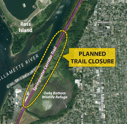
A major project to improve wildlife habitat at the Oaks Bottom Wildlife Refuge will come with a full closure of one the busiest biking corridors in Portland.
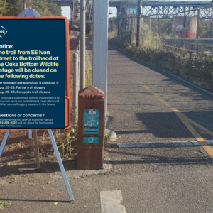
Starting this July, the Portland Bureau of Environmental Services (BES), Portland Parks and Recreation and the U.S Army Corps of Engineers, plans to close the Springwater Corridor path between Oaks Amusement Park and the Oaks Bottom Trail for up to 120 days. Contractors will use the path to stage construction vehicles and move material.
When this same project was first proposed back in 2010 (it was ultimately delayed), it raised major concerns with the City’s Bicycle Advisory Committee. Members of that committee urged BES to use the adjacent railroad right-of-way in order to keep the path open. This time around, the City and the Corps of Engineers incorporated feedback from the community and designed a plan that incorporates barge access and/or rail as a primary haul route. However, the Springwater closure is still necessary to safely complete the culvert and channel grading work in the refuge.
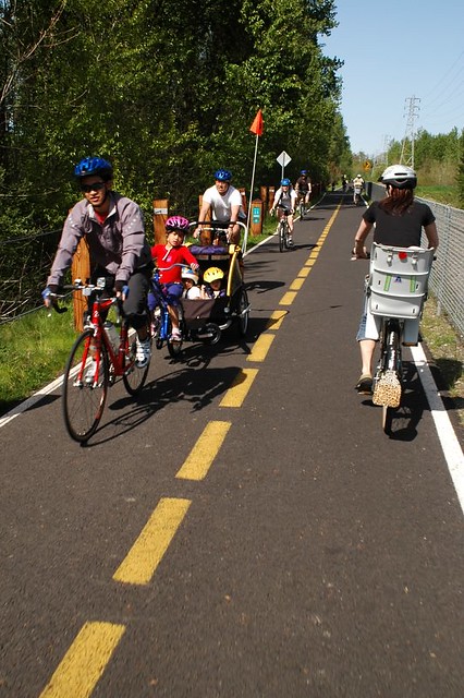
The latest City bike counts show that about 2,800 people ride this section of the path on an average weekday and that number more than doubles on the weekends. The closure is on the same section of path we recently highlighted as one of the top ten most popular Strava segments in the country.
The other point of concern from the advisory committee was the detour plan. The closure will require path users to ride on surface streets, or head to the other side of the Willamette River. In 2010, the north-south options on the east side of the river were not great at all. In fact, they were so bad that PBOT created a bike detour map that listed eight bikeway upgrades they planned to finish before the closure started.
Advertisement
According to BES Project Manager Ronda Fast, they are working with the Bureau of Transportation to develop a detailed map so path users can plan out the best route around the closure. While none of the detours will be as safe, direct, or convenient, the options are better now than they were eight years ago.
The main detour options will be:
➤ The SE 19th Avenue Neighborhood Greenway route (which should be completed by this spring) through Sellwood which connects to the SE 17th Avenue to “Clinton to River” route (via SE Insley/Milwaukie or via SE Harold to pathway along the northeast side of McLoughlin Blvd.)
➤ SE 19th Neighborhood Greenway to the Oaks Bottom “bluff” trail at SE Milwaukie which brings you back to the Springwater path.
➤ The Sellwood Bridge to the Willamette Greenway path on the west side of the river.
In addition to a detailed map, Fast assured me that there will be plenty of signage in the area to warn people about the closure so they can choose a different route without wasting too much effort.
If you’re wondering why the closure has to happen in the busiest riding months it’s because that’s all the “in-water work window” that has the least harmful impacts on federally protected fish.
The project also comes with a new wildlife viewing platform and a turnout that will be accessible from the Springwater path. The turnout will be built over a new fish passage culvert just north of the floating home community. It will be about 50-feet long and add about eight feet of width to the path. The viewing platform will further south just at the northern end of Oaks Amusement Park. It will be about 95-feet long with a landing to park bikes and a ramp up to an overlook. This is good to hear not only because viewing wildlife is cool, but the path is so busy and so narrow in these sections that having a place to pull over and rest or just allow faster trail users to pass will be a nice upgrade.
Check out the official project page for more details.
— Jonathan Maus: (503) 706-8804, @jonathan_maus on Twitter and jonathan@bikeportland.org
Never miss a story. Sign-up for the daily BP Headlines email.
BikePortland needs your support.



Thanks for reading.
BikePortland has served this community with independent community journalism since 2005. We rely on subscriptions from readers like you to survive. Your financial support is vital in keeping this valuable resource alive and well.
Please subscribe today to strengthen and expand our work.
Darn you invasive purple loosestrife!!
Sure is pretty though.
Ok…moving forward to making some lemonade out of this planned longterm closure detour…how about PBoT/ BES make a world class bikeway detour fitting for ~3000 bicyclists a day: intersection upgrades (new signal priority/ stop sign changes), on-street separated facilities, speed limit reduction/ traffic calming, parking removal where needed, etc. There are many examples of best practices out there…versus just throwing up some way finding signage.
How about: temporary road diet on Milwaukie/12th from the Orange line MAX tracks to a block south of Powell – replace the rightmost auto lane with a cone-protected bike lane. Parking removal on Milwaukie south to Bybee, replace with protected bike lane. Bybee to 13th, parking removal, replace with protected bike lane. Ditto on SE Tacoma St to the Sellwood Bridge. The only substantial problem I see is the two curb bulb-outs for crosswalks along Milwaukie in Westmoreland. There is plenty of parking a block or two in from the commercial districts; walking an extra couple blocks is a positive boon for most people, who could stand to move more. With substantial outreach to local residents and copious disabled parking spaces painted and signed and ENFORCED, this wouldn’t have a major REAL (as opposed to perceived) negative impact on businesses or people driving.
It would still be a 5-10 minute inconvenience for people biking, and less comfortable than the path. But it would at least treat people biking with respect. The fact that it’s politically unthinkable says SO much about why Portland is “overrated as a bicycling city.” “Detour to the (tiny, winding, slow, confusing) Westside path” is not respectful or reasonable. Imagine if the City detoured everyone driving on SE Macadam to a “route” along the river on a warren of unsigned, confusing, dirt and gravel forest and logging roads. That’s an equal level of inconvenience, discomfort, and potential danger. It would be unthinkable for the City to propose such a poor detour for people driving. But we’re lucky to even get a sign telling us about this one before we bike 5-10 minutes pointlessly towards a closed path.
If 2800 cyclist per day can give up their main travel/recreation route for the entire summer then it seems a small thing to remove the parking along one of the routes from Selwood to the Tillicum to make make for a safe bike detour.
Ditto for the 20’s greenway that should be.
I would be VERY wary of this timeline. Speaking from the experience of BES replacing a culvert in my neck of the woods last summer/fall (https://www.portlandoregon.gov/bes/article/573861). They closed the street for six weeks, then 9, then 10, then 13 and barely opened it up after that much time. This involved a waiver to extend the in-water work window for the project due to fabrication issues with the culvert and flooding from some rain that passed through the area as summer faded into fall.
The final product is nice (although being in SW it just means sidewalks to and from nowhere) but the bad detours, lack of communication, and repeated delays made it a bad experience. Hopefully with this being higher profile the processes will be better defined but I have serious doubts that the closure will be anything less than 120 days.
Agreed, 4 months will most certainly be 8 or 10 months, in reality. Perhaps worse. Who knows, they may need to stop and perform a survey study and gather “stakeholders” for several rounds of monthly meetings at some point mid-project.
Of course, Ross Island Sand and Gravel will continue to dredge barge loads of rock/sand/gravel from the bottom of the river here all through the critical yearly times of increased fish sensitivity.
Ugh. Ross Island. Good point.
Bigger picture on Fanno Creek stormwater work: that trail has been closed on and off several times going back at least 5-7 YEARS for stormwater management projects. I don’t know all the detail, but my impression has been that pipes under the trail have been replaced, then the project had to be redone another year, maybe more than once.
BES has closed the Fanno Creek Trail for months on end for a failed sewer project. The trail that non-Portland neighbors worked hard to build.
meh.. cross the sellwood, ride a few miles on the west side, come back over the Tilikum, not the end of the world.
“meh” perhaps for those physically fit A+ riders…and speaking for pedestrians…I wonder if the detour will meet Access Board (etc.) standards per ADA…that the long term detour/ diversion be as accessible or better than the route being closed.
A+ riders? Have you even biked the West side route North or South along the Willamette Greenway? It is just as flat as the Springwater, cleaner, better views, and dare I say more interesting. Perhaps the only “hill” would be the Tillicum but even then not any more challenging than Spokane St. or any other road that leads down to the Springwater.
2800 extra riders a day on the Willamette Greenway Trail through the “Private Drive” Apartments?
The HOA is going to have kittens.
Yay! Kittens!
Not the end of the world, but a massive downgrade. Probably 20 minutes longer each way for folks traveling simply N-S on the east side.
Was laying crushed gravel on the dirt hiking path on the other side of the pond and temporarily allowing biking there even considered? That would require people hiking to give up some comfort, but would make the detour much more convenient for people biking.
Huh? Have you ever been on this trail? It wiggles left and right and up and down continuously, and would not be at all suitable for handling commuter bike traffic. Not to mention it is designed as more of a nature experience (viewing platform, elevated paths) than a through path.
I walked on part of it years ago. So no, I don’t have a good memory of it. Thanks for the info, it looked potentially promising on the map…
so you want the active transportation without the active part…got it.
I want active and efficient.
Heaven forbid people want to use bicycling as a form of transportation, and actually get where they’re going.
If it were me, I’d just like active transportation without forced 20-minute detours.
I’d strongly discourage use of the Bluff Trail for cyclists (legal or not legal). It’s narrow and has poor sight lines, even as a runner. I anticipate foot traffic on the trail to increase substantially as an alternate to the Springwater once the Springwater is closed, and as it is there are many places where it’s difficult to pass people head on on foot (especially if someone has a dog — on leash — as at least this person writing is often known to do :)). Anyway, as tempting as it is I just could see so much user conflict occurring with the addition of cycling in this mix.
I really, really, really love the idea of the road diet and removing parking along one side of 7th/13th/Bybee and then Milwaukie from Ellis to Mitchell. I’m headed to the n’hood transportation committee meeting on Weds and will bring that idea up. Detouring to 19th is so much up and down hills for so many users — especially if you are trying to get into Sellwood proper.
Without affordable housing there will be no cyclists…. https://www.southeastexaminer.com/2018/01/petition-calls-for-public-vote-on-rip/
This is dramatically off topic, but if you’re suggesting that preserving exclusionary single-family zoning is better for biking, I have to disagree strongly. Existing zoning was designed to constrain people’s housing choices, and it’s doing that too well. The RIP is an imperfect set of zoning changes crafted from an imperfect public process, but it’s undeniably an improvement upon the status quo.
What does the RIP have to do with affordable housing?
Nothing really, but it is often sold as such. Ask Eudaly about the benefits of RIP and I am certain she would mention affordability.
Live where you can afford to live. The overwhelming majority of the nation manages to accomplish this without a government handout.
RIP is just about Zoning changes to allow for more units on a single lot, there is no government subsidy, it is about lifting government restrictions on only allowing one unit per lot to let the FREE MARKET construct more, but smaller and more affordable to the Working Class, housing units so they can afford to live in Portland.
RIP is going to create housing affordable to the working class? You are literally the first person I’ve heard make that claim.
How is restricting housing density going to help affordability?
Limiting demolitions will slow the disappearance of less expensive housing. If the RIP had strong anti-demolition protections, I would probably support it, even though it will do nothing to create more affordable housing. Without such protections,it will only accelerate the rise in the cost of housing.
Are you working with John Liu on protecting the many thousands of low-income folks living in single-family homes in Laurelhurst from demolitions through a historic district?
No.
You two should think about joining forces; you have similar ideas about how low-income renters in single-family homes in high-income areas are extremely common, and also about how increasing the number of homes makes a housing shortage worse. With your powers combined, we might yet confine those richy rich multifamily dwellers to the busy, noisy, polluted, dangerous major-street “corridors” and stop the defiling of the only remaining refuge of the poor, inner eastside single-family neighborhoods with granny flats and backyard cottages.
The idea that the RIP will produce housing for low-income renters in high-income areas is a fantasy that even most proponents are not willing to indulge in.
I want greater economic diversity in my neighborhood. Replacing older houses with newer ones is not going to achieve that.
Certainly agreed that the actual units created by RIP will be 95+% unaffordable.
But – if you want economic diversity in your neighborhood, sorry, the train has already left the station. Richmond and Sunnyside are rapidly gentrifying, and progress in the other direction ain’t gonna happen anytime soon. RIP or no RIP.
If you want economic diversity in your city or your metro area, we can still keep that if we dramatically increase the number of new units built in the metro area (along with increased renter protections, compensation for displaced persons, etc.). Portland has estimated that we need 22,000 more housing units this year in the City to even get to stability. We’re not building enough housing to make any substantial progress towards that, and in fact are building fewer units than would be needed for the number of people moving here so the situation is getting worse.
RIP is a tiny move but at least it’s a tiny move in the right direction.
Yes — the train has left the station. Which is why I am surprised to hear you and Terry D-M talk about the proposal as if affordable housing were a realistic outcome.
We don’t need more units, we need more units with low to moderate rent, and that can accomodate families. Those aren’t as profitable or sexy to build, so they’re not being built. The RIP won’t change that.
Ironically, the RIP overlay excludes the very areas where affordable housing might get built, while at the same time denying property owners and residents in E Portland the benefits of increasing density.
That’s one aspect of it. One the other hand, it gives incentives to create many small, separate dwellings, instead of larger ones that would better accommodate roommates or extended families. It also allows more floor area if you put additional units in separate backyard structures that reduce garden space and put the units closer to you neighbors instead of allowing you to build that square footage in one larger structure that’s more efficient and uses less land.
It also prohibits building houses as large as what’s typical on many streets.
One effect it will have is to encourage tearing down single-family houses that can accommodate families, extended families or roommates, and replacing them with small units that house one or two people maximum, but cost as much or nearly as much as the house they replace.
Another effect will be to discourage flat, green roofs.
Roommates splitting a larger house is one of the easiest ways to get affordable housing and increased density, while maintaining flexibility for varying family sizes and living situations. The fact that it does not require a fancy city initiative and results in very little developer profit means that it is consistently downplayed.
It’s tried and true, and it works. It’s also the housing model most under threat by redevelopment.
Yes, and besides it working in existing dwellings, there’ve been some great examples of new dwellings set up for it–either for multiple adults, or for extended families. Extended families living together is common in many cultures, including those of people moving to Portland.
But the RIP as is typical of so much planning here touts itself as progressive, while setting up roadblocks to very positive types of development to which it’s currently oblivious. So the new rules will allow a house with two completely separate units, but not allow a dwelling of the same size that doesn’t have two separate kitchens.
As an example, a house set up to accommodate grandparents living with the kids and grandchildren is prohibited, but isolating the grandparents in a completely separate dwelling in the backyard is allowed.
Portland’s regulations that aim to encourage one type of development typically end up discouraging other types of equally or even more positive development because planners’ thinking typically lags several years behind society. So they create new regulations that set behind-the-times thinking into stone.
The problem is that Wheeler treated “Stop Demolishing Portland” activists who oppose any substantial new construction, or even visible ADUs, and pro-Housing activists as equally valid viewpoints. He asked both to come to a compromise. That compromise is RIP. It’s like making climate change policy by compromising with climate change deniers. As long as our electeds treat what I call “housing denialism” – the idea that more housing is bad for the housing crisis – as a valid stakeholder in the housing debate, you’re going to get bad policy like this.
The problem is that actually fixing the housing crisis will take money, probably a lot, and not for showcase projects like the CLT building downtown.
That is another problem. But it is a secondary problem – you could raise and spend a truly extraordinary amount of money on public housing, and if private housing production was still severely constrained, the housing crisis would not be solved because cost-burdening would continue to move on up the income scale. The most feasible solution given that taxes are constrained here relative to say Singapore is to build new public housing for the bottom 10-20% by income, and even more tons of new private, for-profit housing for the other 80-90% by income.
My understanding is that the housing crisis at the top end of the market no longer exists. Who is hankering to build market rate housing for the bottom 30% that you should say should be covered by the free market? It’s not zoning that’s holding that back, it’s economics.
The overwhelming majority of the nation buys their house using federally secured mortgages, sometimes with federally backed mortgage insurance, and deducts the mortgage interest on their federal and state taxes. It’s an awesome handout for those of us lucky enough to be able to take advantage, actually.
WOW.
Have you looked at the wages-cost of living ratio in this city lately? Unless you have a salaried, secure job — and in some cases, even then — you simply cannot earn enough to pay for housing here anymore. Talented, hard-working people who used to be a real benefit to our local economy, education and culture are leaving Portland in droves because they can’t earn enough to stay.
When the city is washed clean of everyone who can’t afford to live here, you’ll have to pull your own lattes. Enjoy your privilege while it lasts.
The large magnitude of suckage from this disruption is inversely proportional to the amount of low-stress, uninterrupted, accessible bike paths.
Portland is working hard to make itself into a city where bicycle transport is an afterthought; only possible where it doesn’t interfere with the increasing level of private motor vehicle transport. Move to Portland and bring all your cars.. you WILL get priority!
Dont worry, we can use the west side. Oh wait, never mind. https://bikeportland.org/2018/01/08/fence-installed-by-odot-abruptly-closes-access-to-willamette-park-at-nevada-st-263925
that’s one little crappy entrance…use the other 4 or 5 of them…
I’m having a hard timer reading the map.
Will people on foot (or scofflaws on bikes) be able to take the trails through Oaks Bottom to skirt the closure and end up back on the Springwater where it intersects with the paved path through Oaks Bottom?
This will be a bummer for the kids attending bike camp at OMSI and our Sellwood Cycle Repair location as it’s their main route to to and from Sellwood. We’ll likely detour to the west side and take advantage of the Sellwood Bridge and Tilikum Crossing.
I would suggest as an email- letter writing pressure point the new head of Portland’s BES, Michael Jordan ( not the basketball one). He was brought in to improve BES’s public image after the Columbia Treatment Plant Building Scandle and is reputed to be very politically savy and connected. Perhaps he has the juice to “encourage” PBOT to do the right thing and install a high quality detour route. If anyone has his official contact info to share that would be good I think.
There is no way the west side bike trail can take up the slack. Maybe PBOT can spend some time making that route better.
Is being purposely obtuse the cool thing now?
A dog could shade moonlight on that.
Seems like the city could offer up their adjacent rail line tracks that never get used as temporary replacement bike path for this period. Simple and done.
That isn’t the city’s rail right-of-way, it is private. Considering they are closing the path, looks like the owner of the rail line dug his heels in on using the rail line for access.
This is terrible.
Perfect opportunity to expand and widen the entire stretch of this MUP from sellwood to OMSI through here. Dedicated bike path (bikes only), anyone? Platinum?
Just ride it anyway.
I guess I won’t be visiting Oaks Park this summer with my kids.
dang sounds like its going all modern 🙁 hope the rare frogs stay alive.
funny, I hope it helps remove the homeless camps.
That’s the best environmental improvement you could hope for in this area.
homeless camps where dude? not near the water, was just there for bike ride last Thursday no issues
I wonder if Hood to Coast knows about this yet. This stretch is a major part of their route.
10 mph limit on the west side path is sure going to put a kink in Fred Timetrial’s training intervals… Sad!
This is the cycling/running/walking equivalent of closing I-5 in the Rose Quarter for “four months” [Translation from builderese: 7 – 8 months]. If that were to happen there would be predictions of carmageddon from everyone, and telling people to cross the river an use I-405 wouldn’t cut it, ditto for I-205.
If the city were really concerned they would have already established a significant, well planned, safe and speedy detour.
An example: I was visiting Winterthur, Switzerland around ten years ago, there was a building project that had closed some bicycle racks, so the city closed a street and turned it into a bicycle parking lot – that is a city that cares about cycling. In fact, in Winterthur there seemed to be more parking for bikes than cars (the bikes were on these great double decker racks).
Umm, no. Even if the average weekday rider count Jonathan mentions goes up in the summer (assuming a corresponding drop in the winter), the 3,000 or 4,000 riders per day are not the equivalent of 130,000 vehicles per day** that travel I-5 year round. (And that’s vehicles, not passengers!)
I ride that stretch of Springwater a couple hundred times a year, and I’m not looking forward to the detours, but I cannot with a straight face say that the Springwater closure would equate with four months of dumping I-5 traffic onto side streets.
** Stats from counts on Interstate bridge traffic between Oregon and Washington: http://www.rtc.wa.gov/data/traffic/bridges/daily.asp
Seeing as this is one of the most popular paths in the city it is absolutely equivalent to closing one of the most popular roads in the city.
LOL, I read the comments on the article from 7 years ago, folks have gotten soft around here. It isn’t perfect, as no detours are (ya know, like, by definition), but SE 19th to the bluff trail is a perfectly adequate alternative. It may be 0.25 miles longer, and the main troublesome crossing is Bybee, which ought to be improved prior to this going in to place, but really is not going to be a big deal. I am pretty sure, short of individual, uni-directional lexan tunnels separated from vehicles, pedestrians, and lycra clad speed demons, the default response would be outrage.
It is only for a few months!
Seven years ago the Oregon City Bridge closed for almost two years. This bridge carries over 12,000 vehicles per day. There was valid concern that the closure would disrupt traffic, causes back ups and gridlock. There were issues but we all survived and I doubt many remember it.
That analogy is erroneous for several reasons, but not the least of which is this- cars can intermingle with other cars safely. As a result of this project, which is removing one of the very few car-free zones in our fair city, I’m going to be intermingling with cars, and that puts my life at extreme risk.
I find your characterization of “I’m going to be intermingling with cars, and that puts my life at extreme risk.” hyperbole.
They’ve been working on this for years. The improvement for a signal crossing of 19th at Bybee is underway, as is the big triangle crossing at the too of the bluff.
Using the west side path is ok, except for the northern part where there are unmarked obstacles, blind corners, large root bumps and an abrupt, unsigned ending in a parking lot. I’d like to think there would be signs to help with this, but I know better.
The springwater needs to widen when it’s done.
This project has been in the works since 2010. The city has had 7 years to prepare and improve alternative routes. That is the standard we should hold it to.
It often happens elsewhere. Check Bethesda, Maryland and the Purple Line light rail project. Bethesda will build some protected lanes next year.
Especially also because about 50% of that Westside greenway path also has a 10mph speed limit, which is absolutely not going to be adhered to by the disgruntled commuters trying to make up lost time for work. And that itself is a hazard, because that speed limit is there for good reason, given the number of zero-visibility corners often containing dog-walkers, strollers and senior citizens.
gotta make room for gas filled wheels taking up the paths.
If the closing continues into the Fall, not enthusiastic about biking home through the wildlife refuge woods on the connecting under-the-tracks Oaks Bottom “bluff” trail to SE Milwaukie in the dark. Comfortable year round on the regular Springwater section with bike light and winter light from the river. But down inside the refuge alone at night, maybe not so much. Looks like it will probably be 17th for the whole route.
I hope there will be some effort made to inform people who use and especially manage the Westside trail that there may be some more traffic.
The Westside trail regularly gets blocked, used as storage area, used by vehicles, etc. and in the few cases where detour signs are put up, the signage and detours are usually horrible. Sometimes agencies don’t even know where the trail is, and all forget it’s an actual transportation route, not just a play area.
Would be nice if someone would give an update. Are we ahead or behind schedule? What are they currently doing now.