
As a cyclist, these offset intersections annoy me.
Portland’s street grid system is pretty tidy (with some glaring exceptions – I’m looking at you, Laurelhurst and Ladd’s Addition). But someone traveling around the city will notice there are places where streets join at a slight offset, which means you can’t go straight across an intersection to cross to a connecting street. This problem is at its most disruptive when a designated bike corridor is offset across a busy street, which is fairly common in Portland. In these situations, someone biking down the comfort of a greenway is suddenly made to interact with car traffic at a complicated intersection, which is inconvenient and adds kinks to an otherwise smooth and easy trip.
As a cyclist, these offset intersections annoy me. As a bike infrastructure nerd, however, they’re great. Planners take this street pattern hiccup as an opportunity to flex their creative problem-solving skills, and as a result, we have some very strange bike crossing designs. Let’s take a look at a few particularly notable offset intersection crossings.
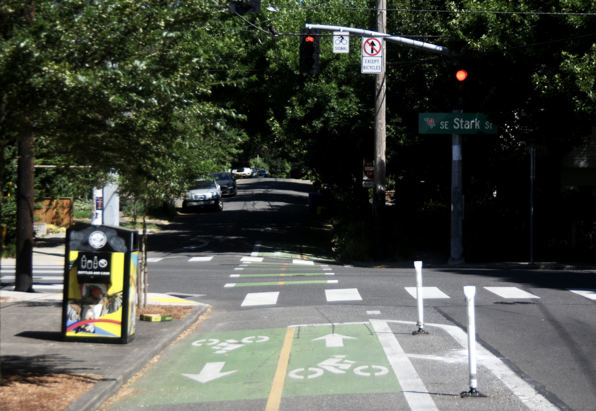
SE Stark Street and 41st Ave
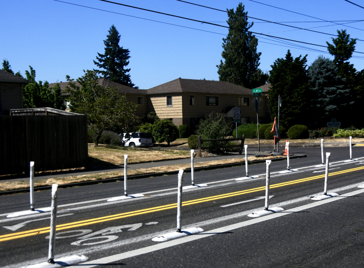
We looked at this particular intersection last year (and even made a video about it), so you can check that out for a more detailed explanation. But I wanted to discuss this design again because it makes for a good comparison with some of the others on this list. Portland Bureau of Transportation planners chose a very unique design here, which includes buffered bike lanes in the middle of the busy Stark St to protect people biking down the 41st Ave greenway at this wide, offset intersection.
These bike lanes are nicely visible to people driving on Stark – even more when paired with the yield signs on the street – and they make it so people biking only have to focus on car traffic coming from one direction at a time instead of constantly needing to look back and forth while crossing a wide intersection. It’s still a little snag in an otherwise smooth trip on 41st, but I’ve had good experiences crossing at this intersection compared to other places.
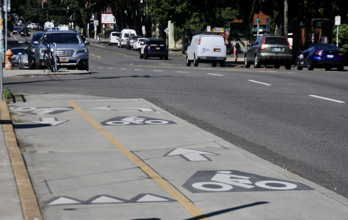
SE Stark St and 30th Ave
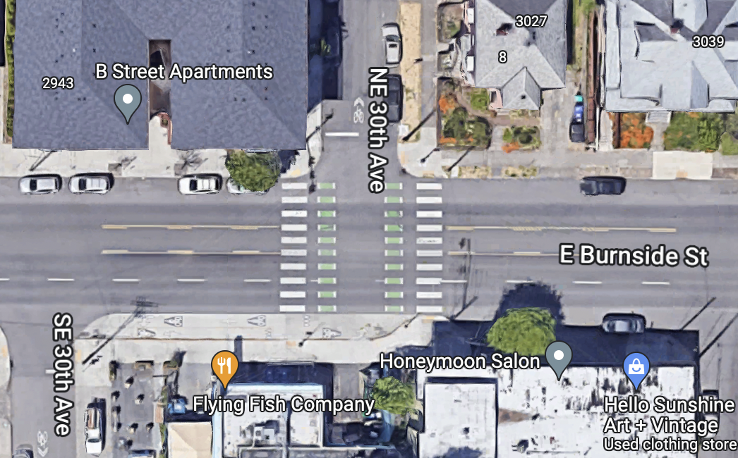
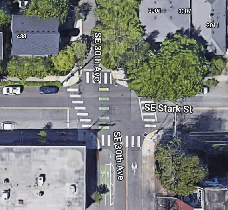
This intersection is just offset enough that if people biking were asked to use a sharrow in the middle of 30th Ave south of Stark, it would make for an awkward crossing. Instead, a short two-way bike lane on 30th – which is to the left of car traffic south of Stark and to the right north of Stark – makes the transition smooth. This isn’t a feasible design for a more wide intersection, but it works quite nicely here to create a smooth transition in either direction.
E Burnside and 30th Ave
The way PBOT has attempted to deal with this offset intersection is very interesting (and PBOT has used a similar treatment at NE 33rd and Going, 33rd and Mason (in progress), NE 55th/54th and Killingsworth, SE 129th/130th and Division, and several other locations). When crossing Burnside on 30th, people biking are directed toward a raised two-way bikeway that serves to separate bike, pedestrian and car traffic to avoid collisions. In my opinion, the problem with this design is that it’s too tight of a turn to get onto the raised bikeway from the north, and if another person was riding a bike in the opposite direction, I would be scared of running into them. This would be a good place for a similar solution as the one on Stark and 41st, but since Burnside is such a busy street, I think it would be difficult to implement that.
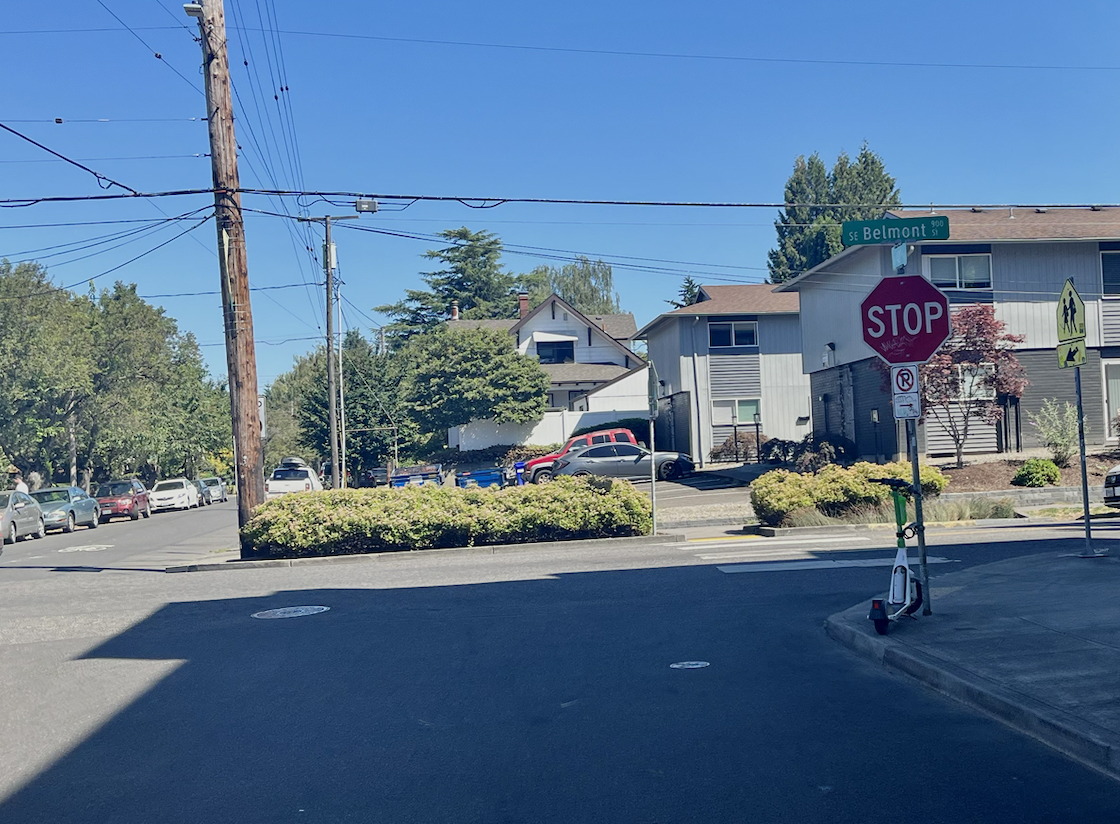
SE Belmont and 42nd Ave
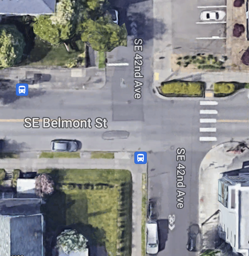
Any attempt to solve the problems an offset intersection presents for people biking is better than nothing at all. This is most evident at the intersection of Belmont and 42nd, in which there is nothing to alleviate the pain of crossing the wide intersection by bike. This stretch of Belmont is busy with pedestrian traffic, and it would be helpful to have separate facilities for people walking and biking. Instead, people biking must choose between crossing at the crosswalk – which includes a tight turn between the hedges on the sidewalk – before getting back onto the street or just crossing their fingers that people driving will see them and stop at the crosswalk.
There is no signage here, and compared to the rest of the crossings on this list, I have had the most negative experiences at this intersection. It’s a shame, too, because the much more pleasant Stark/41st intersection is just a few blocks north of this! I think PBOT could figure out a creative solution here and make it nicer to travel through the Sunnyside neighborhood.
What do you think of these design treatments? Have any ideas for how offset intersections could be better to bike through? Let us know – and stay tuned for a video looking at these streets.



Thanks for reading.
BikePortland has served this community with independent community journalism since 2005. We rely on subscriptions from readers like you to survive. Your financial support is vital in keeping this valuable resource alive and well.
Please subscribe today to strengthen and expand our work.
The entire western third of the city and the entire eastern third of the city both beg to differ…
Ahh yes. I agree with you anonymous commenter. Keep in mind that Taylor is still pretty new to Portland and she’s still exploring the farther reaches of our street grid. In fact, today she’s biking to Milwaukie I think.
I disagree with y’all & think Taylor’s statement is totally fair! Relative to most major cities in the world, Portland has a very neat grid. A perfect grid is very hard to achieve in reality, but we come very close (which is impressive to me given the topography we have to deal with compared to the most grid-like cities in that study, Chicago & Miami)
For major cities in the world, maybe that’s true. But for major cities in the western US (which is in my opinion a more relevant comparison) it is certainly not true. The major cities in the western US that I’ve been to are Portland, Seattle, Salt Lake City, Denver, Fort Collins, Boulder, Grand Junction, Tucson, Albuquerque, and Boise. Of these, all but Boise and Fort Collins have inarguably better grids than Portland, and Boise, Portland, and Fort Collins are pretty close I’d say. And looking at maps of other major cities that I haven’t been to like Spokane, San Francisco, and Phoenix, the same story holds.
Based on what, vibes? Check out that paper, it’s good! Portland & Seattle have essentially indistinguishable grids by any metric (see table 1). Denver is ranked below Portland (although I’d say those 3 are essentially tied). San Francisco is markedly less grid-like.
Yes, based on my experiences actually getting around the cities. There’s only so much info that can be condensed into a single metric; such a metric will never perfectly encapsulate how truly “gridded” a city is.
If you’re in the inner Eastside in Portland, then yes, the grid system is great and better than almost any other city in the US. But for the other ⅔ of the city it’s basically nonexistant. And this sharply contrasts with the other cities I listed above, where the majority of the city is covered by a grid system.
Smells like selection bias. You ever think that commercial destinations tend to concentrate in gridded areas (in part bc they’re easier to access by definition), so as a visitor to another city you tend to remain in the gridded portion?
No one metric is perfect, but that study uses 5: entropy, circuity, proportion of dead ends, average segment length, and average node degrees. Together they’re pretty useful
Even though I understand that most people are more comfortable reading a plan view city map than a topographic map, a plan view map of a city’s traffic grid only tells half or less of the story, you also need to understand the topography. The fact that Seattle has a ‘good’ grid in plan view is largely irrelevant when topography is taken into account.
I should’ve been more specific about where I was referring to. You’re right, it certainly gets wonkier out there, especially in the West Hills. There are also plenty more spots I could’ve looked at, but these are the ones I frequent the most. I’ll keep my eye out for more!
For sure. This is still quite a nice article though, I appreciate your work.
Gonna jump in, the gridded system is pretty tidy, but parts of the city aren’t gridded.
Those offset streets exist for a reason, which we learned in the PBOT/PSU transportation class the year I took it. Much of Portland developed in an ad hoc way as farmers, dairies, or big property owners platted their land. Sometimes the owner of one property didn’t coordinate with the adjacent property owner’s plans, so the sets of streets don’t line up at the old property line.
What you say is true, but many of the offsets are deliberate too, imposed by the city or county to deliberately differentiate (and thus create) a hierarchy of streets – Arterial, Collector, Local, and so on – so that future land owners and developers knew ahead of time what the intensity of land uses were likely to be and that certain corners are likely to be more valuable than others. There was also the issue of horse-drawn carts and streetcars and having to negotiate through intersections, a bit like cargo bikes with trailers…
Compared to other large West coast cities like Seattle, Tacoma, and SF Portland has a very tidy grid
Again, that might be true for inner SE Portland. But it’s absolutely not true for the city as a whole. Inner SE Portland has a great grid system compared to most cities, but all the other cities you mention have a grid system with a much greater geographic extent in the city.
Has Portland tried doing an offset intersection on a collector or higher with all markings and signage removed on all 4 streets, so that no one has the right of way?
My vote for the most controversial offset design is at 108th & Ned Flanders.
Another to add here, with its own design different than those you mentioned, is 41st and Division. I generally do not use the left turn box they painted on the road, as I feel vulnerable stopped with my back to traffic. Usually just wait for all-clear in both directions and hope the westbound traffic behind the blind corner isn’t going too fast.
Totally. I avoid using the 40’s bike/greenway mostly because of this intersection at Division and the one at 42nd and Holgate. I kinda think the whole 40’s way is pretty-I’ll be nice-“weird’, so I generally use 52/3rd instead, at least up to Sandy.
I like the interactive maps in the article.
I think for any offset intersect as long as it isn’t too offset should be closed to through traffic. Trying to support both cars and bikes in all directions is what complicates these intersections. Made a quick overlay what should happen to Belmont and 42nd https://imgur.com/a/6yO5XIu. Close off car through traffic on 42nd, and allow bikes to permeate at a slight angle across Belmont. With the addition of curbouts, any ambiguity is removed.
On any given week I’ll bike multiple times through all four of these intersections, as well as some of the offset intersections in the northeast, such as Going & 33rd, or my least favorite of all, Skidmore & 33rd. I also think Division & 41st is a worthy addition to your list. Oh, and 47th & Davis. Eight distinct treatments for similar intersections.
The overall feeling I have about them is that they represent a failure to consider the most vulnerable users of our greenways. I want the greenways to be safe for riders of all users and abilities, but some of these intersections can be stressful and intimidating even for experienced cyclists. If I was a parents with children following me, I don’t know what I’d do. Yet these are supposed to be the safe, low stress routes?
To me, the answer to improving these all is simple and straightforward: any time a greenway intersects a street with high traffic or limited visibility, it should be signaled. It doesn’t matter if that inconveniences drivers as long as it improves safety for people on foot or bike.
I had to remove a construction sign from the middle of div and 41 a couple of weeks ago. I wish pbot would train their workers to NOT TREAT BIKE LANES AS SIGN PLACEMENT ZONES.
See, now that’s the Maintenance Bureau and not PBOT putting their signs in the bike lanes.
I’m mostly not a fan of these treatments as 3 of these 4 intersections annoy me because:
I would also say that an intersection that is notably missing from this list is NE Prescott & 37th, which is offset for cars, to which PBOT’s solution is to…route cyclists onto the sidewalk?
prescott and 37th is a horrendously dangerous intersection that has been made more confusing by recent painting. I don’t ride it often enough anymore to offer a good solution but I used to ride north on the west sidewalk to get a clear view of both lanes of traffic before advancing. The paint/wands now are super confusing to me.
I take the lane.
Portland’s most embarrassing intersection? A former project manager for PBOT once told me that they had lobbied for Prescott as the street for the greenway that ended up being the Going Greenway- Iwas easy to follow, direct, had comfortable grades and signals. It was shot down because it is beloved high-speed shortcut.
Prescott! That is one of my personal dreams and I know PBOT will find the courage to make a quality bikeway on this street soon. It’s just so perfect and ripe. And it connects directly to the I-205 path, bike improvements on 102nd/122nd and a school and several neighborhoods!
Almost all the arterials and collectors have gentler grades than the neighborhood greenways. Climbing to the top of the hill on SE Salmon at 30th is a particularly egregious example, as are the numerous hills on the SE 28th-29th North-South route south of Belmont.
Great article, Taylor! This involved more research than 99% of articles I see on other sites now days, and you’ve got aerial photos and street-level photos for all the locations.
I feel like the varied designs are all appropriate for their respective crossing. The 41st and Stark crossing is pretty low traffic so it’s easy to cruise into that diverter and make the turn, as opposed to the 30th and Burnside crossing which is much busier and a much wider street, this diverter makes it easier for all abilities and skill levels to cross (I love this one). The Stark and 30th one is nice because there isn’t that great of and offset, but the bike lane lines up so for north/south riders it’s a straight shot with less interaction with traffic. And for the 42nd and Belmont one I think we at least need a flashing light warning so people are aware we are trying to cross.
One more area that needs some help is going north on 21st from Clinton and trying to get to Ladds. The bike box at the Division light is nice but there’s often a car in it. Even when there isn’t they will try to speed ahead of you and cut you off by turning right onto 20th. I feel like it’s usually ok with fast riders, but I’ve been riding a lot lately with less experienced people and see how it can be pretty stressful there. I think a bike only green light would be great even if it just gave a 10 second head start.
For the ones that require a 90 degree turn before crossing, I wish there was a convex mirror so you could see the approaching traffic behind you. Eg, 33rd and Going and 30th and Burnside.
So, yeah, you’ve hit a few good touchpoints. I’m a longtime bike rider so I’ll tell you how these intersections affect me.
They don’t. I avoid them because they’re stupid. And since I rode there before the “bike treatments” i know how to navigate them.
Stark & 41- I never find myself here because the detour the bikeway takes is too far out of my way. I ride up 45th and take stark to 42nd and ride through the pleasant neighborhood instead of detouring west, then east, then west again.
Stark and 30 and in fact the entire 20’s bikeway: oh for the love of. This is such a silly unpredictable path. None of the crossings follow the same pattern. The signage is unpredictable, as is the placement of the beg buttons. I use that particular bike path _only if_ the light is red and drivers are waiting. Last time I rolled up I missed the sensor apparently and my signal, so I ran the red after the cars going north on 30th had passed since I knew I would have to wait for another full signal cycle otherwise.
Burnside and 30: The 12 feet or so of raised bike lane has a curb that makes hitting it southbound downright _dangerous_. So I exit 30th onto burnside and take a lane like, oh, I don’t know, a normal person would.
Oddly, belmont and 42 is the easiest of all of these to pass. Narrow cross-street, I don’t often see SUV’s parked up to the corner, and the zig is very direct (e.g. I only need to do a 45 angle pass, not a full 90 followed by another 90). I’d love some green paint but this one is the best of all of them- which is telling.
Keep doing what you’re doing.
Budgets matter
41st and Stark: “These bike lanes are nicely visible to people driving on Stark – even more when paired with the yield signs on the street – . . . .”
Yield sign: inverted triangle = you must cede right-of-way
Warning sign: diamond = you must reduce speed and proceed with caution
Those are diamond-shaped warning signs on Stark.
Following the rules of the road makes people in cars or on bikes more predictable and is safer for everyone.
Drivers have the legal right-of-way on Stark at this location.
One cannot give their legal right-of-way to someone else. Trying to do so is not ‘polite’, it’s encouraging someone else to proceed illegally. Cyclists need to wait for an opening in traffic – the same way they would drive a car when cross-traffic has the legal right-of-way.
It is worth mentioning that two of these intersections have traffic lights that stop motor vehicle cross-traffic.
Motor vehicle traffic is seldom so heavy on the other two intersections that I don’t have an opening coming up any time soon, but when that’s the case, I’ll dismount and walk my bike through the intersection in the crosswalk – stopping cross-traffic legally by breaking the vertical plane at the curb. (I know you don’t have to dismount your bike to do that legally, but you can, and it makes it less confusing to most drivers.) This has the added benefit of parting the sea for other riders waiting to cross.
I live in the neighborhood and have yet to see a single cyclist use that two-way bike lane at SE 30th and Stark, and it’s been there for over 5 years now.
The problem as I see it is the bike lane is actually on SE 29th south of Washington and PBOT expects cyclists to go over one block to 30th just to use that facility to cross Stark at the light (which takes forever to change and doesn’t last very long), and then you have to climb the hill on SE 30th north of Stark.
Personally, I just stay on SE 29th, and can cross Stark a lot faster at the unsignalized intersection at SE 29th and Stark, and there is no hill to climb on SE 29th north of Stark.
Not only are all of these different designs counterintuitive to use, but the fact that they are all different inspires very little confidence in PBOT’s design engineering skills.