
(Images: ODOT and Google Street View)
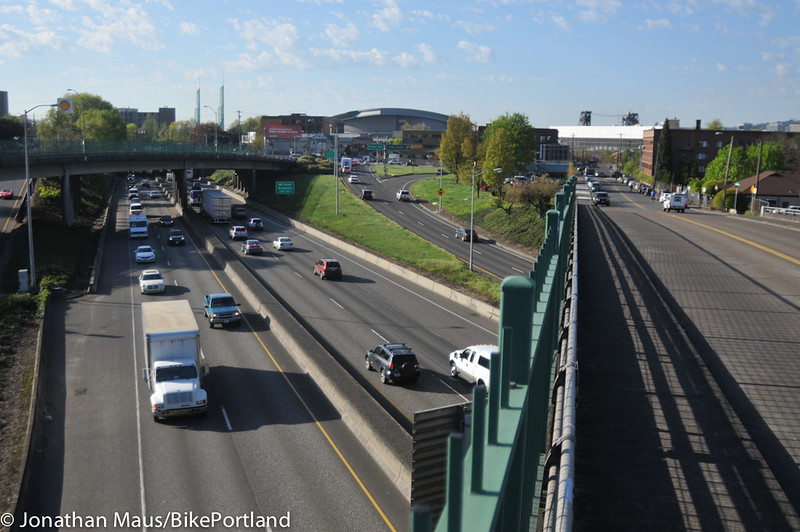
When they explain their support for spending hundreds of millions to add two new on/off freeway lanes and freeway shoulders to Interstate 5 at the Rose Quarter, Portland city leaders have a go-to answer: better surface streets.
It’s true, Mayor Ted Wheeler conceded last month, that more freeway throughput at this interchange would do “very little to arrest congestion.” Instead, more driving is likely to fill any new space that might open up on the freeway, ultimately leaving cars and trucks as jammed as before (though possibly elsewhere on the road system).
But from Portland’s perspective, Wheeler said, the $450 million Rose Quarter project is “mostly a bicycle and pedestrian play.”
OK. So we wanted to know what, exactly, are taxpayers getting in this location that would improve biking and walking?
“We think it has the potential to do a lot of great things … Improvements that the city almost certainly could not afford to do on our own.”
— Dylan Rivera, PBOT spokesman
“We think it has the potential to do a lot of great things for the central city and to reconnect neighborhoods that were disconnected by the original construction of I-5,” city transportation spokesman Dylan Rivera said in an interview last week. “Improvements that the city almost certainly could not afford to do on our own.”
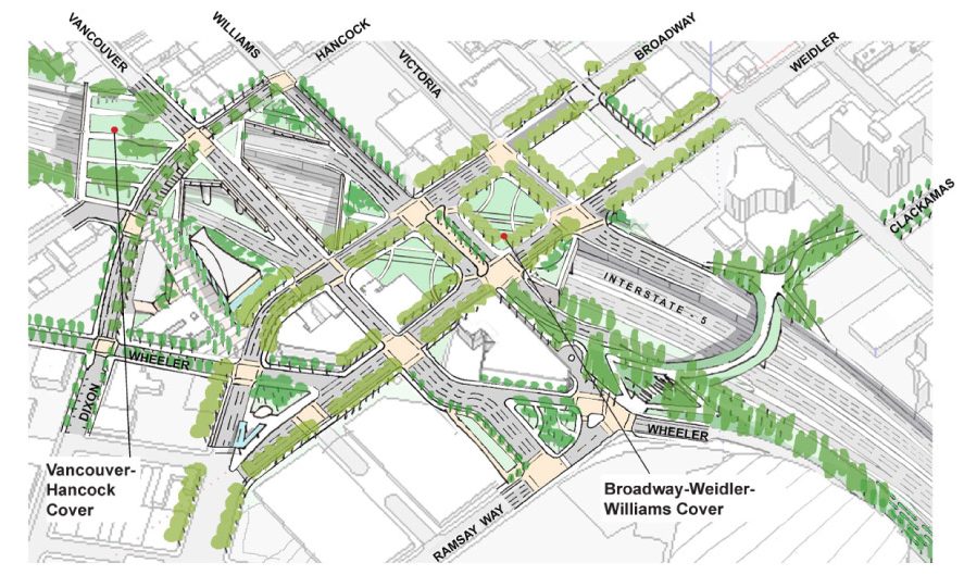
We’d asked Rivera and Oregon Department of Transportation project manager Megan Channell to shine some light specifically on what would happen to all the bikeways in this area — arguably the single most important biking crossroads in the city. Four of the five intersections with the city’s highest bike counts are in the project area: Vancouver/Russell, Interstate/Lloyd/Oregon, Williams/Russell and NE Multnomah/Wheeler.
Here’s what they said the city would get.
A southbound connection to Broadway that’s closer to the Broadway Bridge
The Flint-Broadway-Wheeler intersection has been a major trouble spot for years due to Broadway’s blind-spot-enhancing curve, the number of bikes, the number of trucks, and political pressure to preserve access for everybody. The worst of this problem was mitigated in 2012 after then-Mayor Sam Adams personally backed an end to right turns onto Wheeler Avenue.
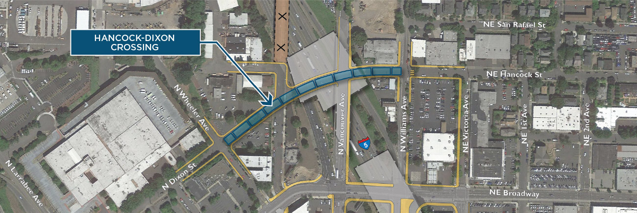
The state and city say they’ve got a new fix for this problem: redirect the thousands of bikes coming south from Vancouver Avenue each weekday off that curving stretch of Broadway.
Instead of sending people heading toward the Broadway Bridge right onto Russell just south of Legacy Emanuel Medical Center, then left onto Flint and finally right onto Broadway, the new project would instead have people stay on Vancouver for a while, then use a new right turn onto Hancock just before the crossing of I-5. (A new traffic diverter at Williams and Hancock would prevent major east-west auto traffic on the new bridge, Channell said.)
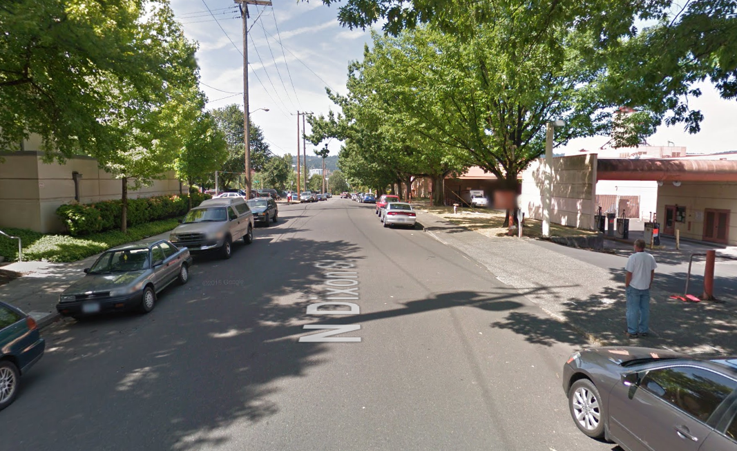
Across the freeway, Hancock would become Dixon Street:
“The new connection provides an alternate route to keep you out of the Broadway-Weidler interchange with I-5,” Channell said. From Dixon, she said, “there could be any number of connections down that would get you to Broadway.”
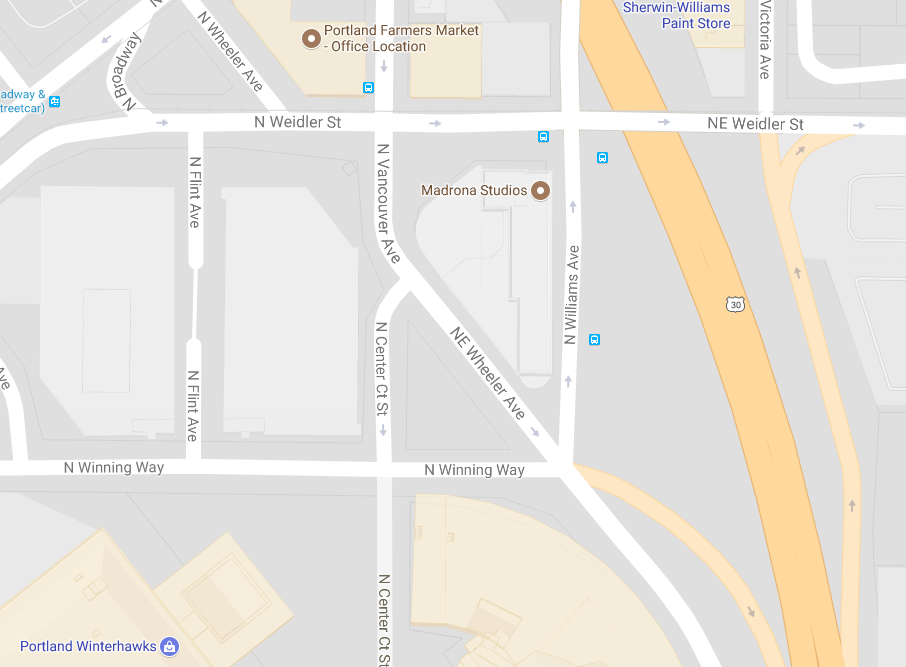
A new biking-walking bridge northeast of the Moda Center
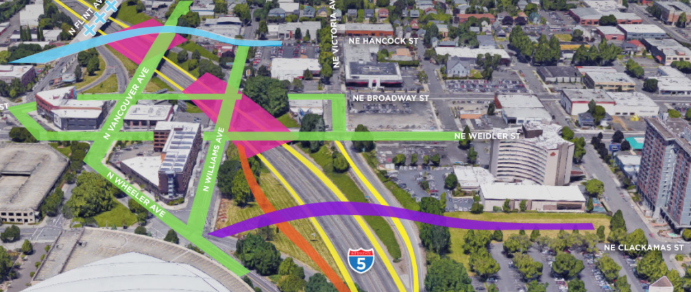
This would join a gap in the grid created by the freeway by connecting Clackamas Street, east of I-5, to the street west of I-5 and just north of the Moda Center that’s currently called “Winning Way” but due to be renamed “Ramsay Way.”

Clackamas isn’t currently a major biking or walking route because it currently T-intersections into a parking garage a few blocks to the east, but if this bridge were built and that parking garage eventually redevelops — it’s owned by the same folks who recently developed Hassalo on Eighth — this Clackamas-Ramsay bridge could create a useful connection to the Moda Center area that doesn’t require going north to Broadway or downhill on Multnomah and then back uphill. It might also make the Moda Center itself, and the nearby blocks, a more attractive place to live or open a shop, which could bring more activity to this close-in neighborhood at all hours of the day.
The state and city have heard active interest about building in this area if these new connections were built and the freeway caps were to reduce traffic noise somewhat, Channell said.
“There are a number of interested developers for properties within and adjacent to those properties,” she said.
Here’s ODOT’s conceptual cross-section of a new bike-walk bridge here:
“This is also the current route for the Green Loop project, so this would solve a major crossing for the Green Loop,” said Rivera, referring to a proposed series of protected bikeways and walking investments that would join the Park Blocks, redeveloped Post Office site, Broadway Bridge, Central Eastside and Tilikum Crossing. “And like the rest of the Green Loop, this segment has not been designed, we don’t know what kind of structure it would be, etc.”
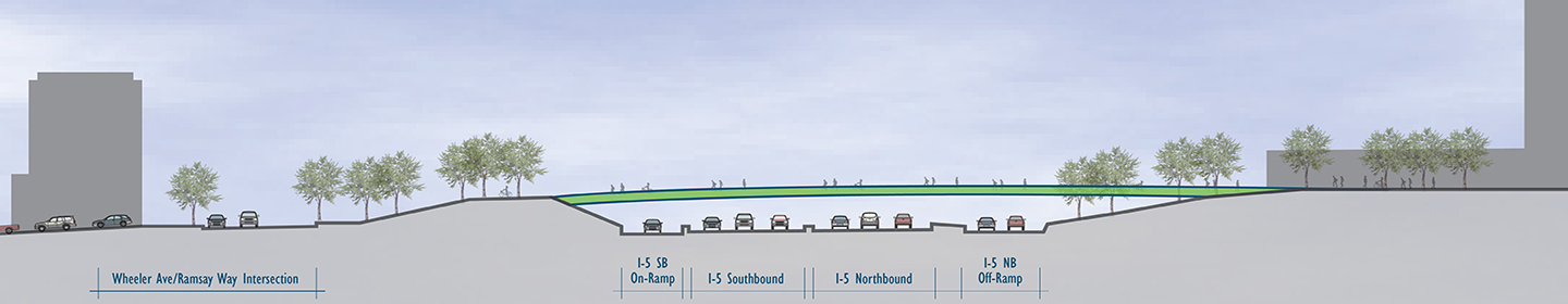
The freeway caps would allow wider sidewalks and bike lanes without the need to remove space from cars
Broadway and Weidler Street are important east-west routes for biking and could become much more important if the bike lanes on this corridor are ever upgraded downtown and/or through inner Northeast Portland. But Channell and Rivera say the bridges across I-5 (which are ODOT-controlled because they cross the freeway) create pinchpoints that prevent bike lanes and sidewalks from being widened and/or protected.
Rivera said a steel or concrete roof over the freeway between Broadway and Weidler (that is, the block to the left in the image above) would create room to shift the roadway over, making “more width for modern bike facilities.”
“The city would be looking for some sort of protection or at minimum a buffer” for the bike lane, he said.
The sidewalks, too, could be widened and better lit, Channell said. And the caps would reduce the noise and smell from I-5.
Today, she said, “as you’re biking or walking across, it feels very much like you’re crossing an interstate. The highway covers would make it feel like you’re just crossing a city block.”
A more comfortable bike route from the Rose Quarter to Williams Avenue
Channell said the southernmost block of Williams Avenue, between Wheeler Avenue and Weidler Street, would be converted to a “woonerf,” a Dutch word for a street where motor vehicles are guests, biking is welcomed and people walking have the right of way everywhere.
As you can see in the green-tinged rendering of the freeway caps above, there is some concept that the new Clackamas-Ramsay bike-walk bridge, which would land at the south end of this block, could integrate smoothly with a northbound bike route on this block.
In fact, Channell said, the only motor vehicles allowed at all would be northbound buses. (TriMet’s 4 and 44 buses currently run up this street nine times per hour in the weekday peak.)
Advertisement
Transportation advocates raise concerns
As we’ve been reporting, a coalition of advocates for better transportation, emissions reduction and social justice loudly oppose the project. Oregon Walks, the Community Cycling Center, OPAL Environmental Justice Oregon, BikeLoudPDX, anti-climate-change group 350 PDX, the Portland branch of the NAACP, the Irvington and Eliot neighborhood associations and the east Portland-based Rosewood Initiative are all among the groups that signed a letter from the No More Freeways coalition opposing this project. So have more than 400 individuals (including, I should disclose, me — see note at end of story).
City Planning Commissioner Chris Smith, a convener of the coalition, has argued that even if the investments described above (including longer, less crash-prone on- and off-ramps) are improvements, the region could find fairer and more cost-effective ways to spend $450 million.
For comparison’s sake, that sum is seven times larger than the citywide Fixing Our Streets maintenance and safety program approved by city voters last year — enough to keep that program going at its current dollar level until 2048.
Aaron Brown, a spokesman for the No More Freeways campaign, raised various concerns in an email specifically about the bikeways:
The Hancock-Dixon crossing would have a steep slope for people heading east. “Yes, it’ll be a more comfortable ride going west,” Channell confirmed, noting that most bike traffic here would be heading west on the way from Vancouver to Broadway.
The Clackamas-Ramsay bridge would be “essentially not functional for modern bike transportation planning” because of the climb required to get over a new I-5 onramp. Channell said she’s unsure of the necessary height of this bridge, but that on its east side it “will be hitting at grade with Clackamas.” “Yes, there will be a touchdown on the west side of I-5, so we’re looking at different options there to make sure it’s an easy and usable connection,” she said. “I don’t think that it would be unusable.”
“At no point in the process did the committee or engineers consider how to make service improvements on the existing infrastructure and the existing crossings.”
— Steve Bozzone, stakeholder committee member
With four-lane streets on both sides and a six-lane freeway below, the Broadway-Weidler caps “will be the most expensive, unpleasant, under utilized park spaces in the city.” Channell said the caps would probably be more important as ways to create new bikeway and walkway space than as parks. “It’s too early to say whether there’s grass, if there’s an active use there, food carts, a plaza,” added Rivera. “That’s one good question for the public.”
Doug Klotz, a co-founder of Oregon Walks and influential pedestrian design advocate who signed the No More Freeways letter, added a critique of his own in an email. According to a poster shared at a project open house last week, many of the street corners created by the project are expected to be rounded off, a design that allows easier turns for semi trucks but also encourages fast-turning cars and makes pedestrian crossings more dangerous.
Here’s the Broadway-Weidler freeway cap area, with north to the right and red arrows by Klotz:
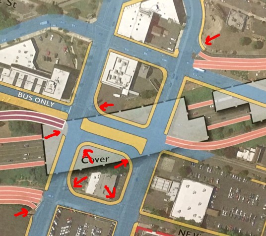
The project’s “design phase” has barely begun, so details like those corners are the sort of thing that might change due to public pressure. But they’re an indication of how ODOT’s staff has been thinking about the project so far.
Steve Bozzone, an Oregon Walks board member and Boise neighborhood resident who served on the Rose Quarter project’s stakeholder committee in 2012 and was one of the few to vote against the project then, said in an interview this week that it was clear throughout that early process that auto movement was ODOT’s priority.
“At no point in the process did the committee or engineers consider how to make service improvements on the existing infrastructure and the existing crossings,” he said. “It was always assumed that ODOT would be allowed to bulldoze all of the bridges and we’d start from scratch. … What we never did as part of the process was look at things starting from the pedestrian perspective, saying, ‘What do we need here?’ The process hasn’t been guided by pedestrian access, pedestrian mobility. It’s been an add-on to a freeway expansion project.”
Want to speak with project staff and see the plan in person? ODOT announced this week that it’ll lead a walk and bike ride through the area at 10 a.m. on Saturday morning. Want to comment directly to ODOT? You can let them know what you think here. The comment deadline is today.
— Michael Andersen: (503) 333-7824, @andersem on Twitter and michael@portlandafoot.org
Disclosure: Last month, I signed the No More Freeway Expansions petition in my personal capacity because I don’t think any amount of public money spent to increase urban freeway travel can be morally justified. Climate change will do too much damage to our children’s lives to spend money on almost anything that further encourages urban driving. That said, I also think the public deserves a fair view of the tradeoffs, and that’s what I’ve tried to offer here.
Never miss a story. Sign-up for the daily BP Headlines email.
BikePortland needs your support.


Thanks for reading.
BikePortland has served this community with independent community journalism since 2005. We rely on subscriptions from readers like you to survive. Your financial support is vital in keeping this valuable resource alive and well.
Please subscribe today to strengthen and expand our work.
“or at minimum a buffer”.
situation normal.
It’s hard not to get excited about that level of ambition.
$450,000,000 could repair so many orphan highways in and around Portland.
By my back-of-the napkin calculations, the Clackamas crossing is going to need climb roughly a height of 25-30 feet between Wheeler and the proposed new on-ramp a couple hundred feet away. The simplest straight-line shot puts that at about a 12% grade. I can’t see a lot of commuters being excited about that. Even if you stretch that out to 400 feet or so with switchbacks, it’s still a 6% grade. There isn’t a lot of room to work with at that location. The conceptual cross-sectional drawing shows this rise but has that section covered with trees, like that somehow helps.
The design engineers don’t seem to understand the effect of topography on cyclists, very typical…
If your informal calculations are consistent with what the engineers have before them, I think it’s likely they can work out something to bring the climb grade to an acceptable rate, if they’re given that assignment. I’m not sufficiently familiar with the area first hand to offer a suggestion, but I think anyone closer and interested in what might be done, would do well to go there and take a look.
The left side of the conceptual cross-sectional drawing you refer to that has that short steep section, could be reduced with fill, or a ramp originating further to the left. Something could likely be worked out to create an acceptable grade. It’s just money. They want and need to do the work on I-5. If it takes doing excellent work on the surrounding infrastructure to get the green light, they may be persuaded to come through with excellent work.
If 6 or 12% for 25 to 30 feet is a problem, you must be from a flat part of the planet.
The Kingston bend out of Washington Park towards the zoo is about 12%. Completely unreasonable for a brand new bike specific path.
If you think 6-12% is acceptable for an urban bike path you either don’t bike commute or misjudge gradients. Also, the distance range is actually 200-400 feet, not 25-30.
Tilikum is borderline-devastating to some riders. And that’s okay- but if you think 5-6% is no big deal, you need to rethink.
“Tilikum is borderline-devastating to some riders. …” timmons
Just so everyone has an idea of what type of rider you think might have a problem with the grade on the Tillikum, you might offer an example or two. I think people lacking the physical conditioning for biking at all, and that are riding a single speed cruiser, could have some difficulty, although if they began to ride somewhat regularly like a commuter would, they might well build up enough muscle strength to climb this modest grade.
Most hybrid bikes have gears don’t they? With a low gear, I’m guessing the Tillikum grade could be very doable, even for people not conditioned for biking. Bike share bikes have gearing, though I hear they’re very heavy bikes. If low gear on those bikes can enable a not particularly fit person to ascend the Tillikum grade, that might serve as a sort of baseline.
An example for webob:
My “interested but concerned” partner and I discussed cycling from south PSU to Division and 28th today. When I suggested that we ride the Tilikum (by far the shorter route) my partner literally told me to f#@% off. Instead, we detoured to the Hawthorne Br and Ladd’s addition because this route bypasses much of the unnecessary elevation gain.
In fact, my partner actively avoids much of the new infrastructure in inner PDX because it requires too much cycling effort. My partner also avoids downtown entirely (except on early weekend ams) because they loathe riding next to aggressive motorvehicle traffic.
This pathetic reality is why Portland’s cycling mode share has stagnated for a decade.
soren…thanks for the example you offered, but did you read my comment to which you’re responding? You didn’t tell us anything about your partner; level of fitness or type of bike ridden and what it has for gearing, or whether it’s an e-bike.
All of that, I think is relevant to the type of bike and pedestrian infrastructure that people involved with and responsible for conceiving, designing and building this type of infrastructure, try to build into projects with the situations set before them.
For bike and pedestrian infrastructure in Portland projects, would you propose for example, 6 percent as a maximum grade the city should be obliged to hold itself to for any such project? Or a gentler grade like 3 or 4 percent? It’s not like grades of this degree can’t be accomplished on steeper terrain, but it can get very complicated to do it, and expensive, to the point that…the task of getting the support for what’s involved, becomes formidable. That makes compromise likely.
Engineers can do anything if they’re given the time and money to do it. These bike-pedestrian bridge approaches some people in other comments here are concerned that, or convinced that planners are not thinking of…that they’re not going to be able to provide a sufficiently gentle grade, to meet the needs of even the least strong walkers and riders: authorize them to do it, and engineers could figure out a way…whether the way is a longer approach over multiple street blocks, an ascending radius, or punching through a building to do it.
Through the RQ project, I imagine there are ways to make the biking and walking experience great…but people have to be willing to try think of ideas of how to do it, and not be put off so easily by what’s initially put before them.
An interesting example.
If a bit of grade for a couple hundred feet or the downtown infrastructure is such a disincentive for someone I’m guessing is friendlier to cycling than most, it says something about what can realistically be expected. Recently in interview printed in BP, a young healthy woman indicated cycling wasn’t an option if it was going to mess up her hair or require more than light effort. Keep in mind these people are probably more inclined than the average person to cycle — and that it appears that their rides might actually be easier than average.
Infrastructure can be made as friendly as it can be. But hills, weather, distance, time, being presentable when you arrive, and everything else that is an inherent part of cycling will still be there.
I am an athletic bicycle commuter averaging about 10 miles a day, a good portion of them with a cargo bike and 1-2 kids (and no e-assist). I take Tilikum crossing back from work and find the climb at least annoying with my road bike. I also ride the Steel bridge to work and love it. If this is my reaction, then you can extrapolate to other bicyclists.
My concern with this whole project is that, because these are add-ons, ODOT will just not be very careful about designing the bike infrastructure; they just do not understand. So they will build something, then declare success, and we’ll have more suboptimal, frustrating bike infrastructure. And that is a bigger problem not restricted to ODOT, that people just think putting some bike infrastructure in place if sufficient. It is not.
“…My concern with this whole project is that, because these are add-ons, ODOT will just not be very careful about designing the bike infrastructure; they just do not understand. …” Stephan
What do you mean by “…add-ons…” relative to this project?
What I’m understanding from what I’ve read about the project in bikeportland stories, is that the bike and pedestrian components are integral parts being made towards helping rebuild the functionality of this neighborhood for travel within it by means other than motor vehicles.
Read the most recent bikeportland story which tells of a couple ODOT officials and another person leading a tour this past weekend, of the project area, in which they explained the biking and walking components of the project. One of the statements in that story says that the bike and pedestrian components are at this point, only five to ten percent designed. Story says the agency is looking for input from the public about how to proceed with the design.
I think people are going to have a better outcome for walking and biking infrastructure from this project, if they put a little more effort towards resisting temptation to be pessimistic, and instead genuinely imagine what form the active infrastructure needs to and can take within the physical limitations there, towards realizing what could become a much better place for walking and biking in this neighborhood than it is now.
I’m not saying stuff like this is nothing or that we don’t need serious efforts to make bike infrastructure as accessible as possible. I agree that you can’t just put in bike infrastructure and that people need not accept all bike infrastructure suggestions at face value.
But, we shouldn’t pretend every problem can be engineered away.
The Steel Bridge is low because it’s a draw bridge. Given that both sides of the river are low, what realistic alternatives do you see short of also making the Tilikum a drawbridge keeping in mind that part of the reason it’s only for transit and foot/bike is to reduce cost?
Engineering out the hills, weather, distance, and other factors that makes cycling inconvenient might also be impractical.
“bike and pedestrian components are integral parts”
Perhaps. Or perhaps it is window dressing, PR fluff, hot air. Lots of smart people posting to bikeportland in comments below these recent stories here are suggesting as much. Perhaps you can explain why you interpret what ODOT says and does straight up?
“instead genuinely imagine what form the active infrastructure needs to and can take within the physical limitations there, towards realizing what could become a much better place for walking and biking in this neighborhood”
Really? You are accusing the folks here who have reservations, are jaded, hold out very little hope that this is all going to turn out hunky dory for those not in cars, as lacking imagination?!
“I’m not saying stuff like this is nothing or that we don’t need serious efforts to make bike infrastructure as accessible as possible. I agree that you can’t just put in bike infrastructure and that people need not accept all bike infrastructure suggestions at face value.
But, we shouldn’t pretend every problem can be engineered away. …” bannerjee
First…people need to be willing to try conceive ideas about what might be done to work out challenging bike and pedestrian infrastructure situations. Initially, any possibly reasonable idea outside of for example, something like personal velocicopters to lessen the exertion involved in ascending climbs with a bike, could potentially lead towards a good conclusion. Read this most recent bikeportland story in which writer Emily Guise for bikeportland reports:
“…ODOT repeated throughout the tour that the bike and ped plans are only 5-10% complete and they are looking for feedback.” https://bikeportland.org/2017/10/09/on-the-ground-with-odot-recap-of-i-5-rose-quarter-project-bike-ride-246097
People reading here that are interested in the future shape and form of biking and pedestrian infrastructure in the RQ, ought to be trying to help come up with some good ideas to work out the inevitable challenges likely to be encountered in efforts to make that infrastructure be as great as possible. Instead of this repeated doom and gloom resignation too many people confine themselves to in their comments to this story.
If people that actually are riding the bikes and that are walking the streets in this area, aren’t even going to try come up with some good ideas, and aren’t going to make efforts to convince people to build something really great for biking and walking and community building as part of this project, that will be a responsibility of theirs that they’ve neglected to tend to.
There will inevitably be compromises, but their also may be ideas to explore for biking and walking infrastructure that won’t be the bad scenario some people commenting here seem to think this project in its very initial stages as is, will turn out to be. Come up with some good ideas, see if the engineers can do it, and what more it’ll cost. Then find out if the people will be willing to pay for it.
Bikes may be geared plenty low, but many people don’t know how to use them. To compound matters, the weaker riders often have heavy bikes which are further weighed down with all sorts of сrаp. The effect is to make their ride both miserable and slow — I’ve always suspected this is partly why Tilikum use is low.
Having said that, you only can do so much to flatten elevation that needs to be covered. Paths that stretch things out take loads of space that has to displace something. Switchbacks create their own issues.
BTW, PSU to Division and 28th can make sense either via Hawthorne or Tilikum — at one time, this segment used to be part of my daily commute. The distances are virtually identical, and the Hawthorne route is arguably better all around in terms of flow even if the Tilikum bridge could be made completely flat.
Do you notice in their comments in speculation about how some people riding, react to the rate of grade of the Tillikum, and on the briefest of ideas about what the rate of grade for the pedestrian and bike crossings of the I-part of the RQ project, may be, Timmons, Bradwagon, and Soren, suggest that grade is an obstacle they seem to believe too many people riding n Portland, can not or will not be able to handle?
…And that they offer no alternative ideas or suggestions for creating a more easily manageable grade for those crossings?
At least do some informal tests to try find out who is having difficulty riding the Tillikum’s 6 percent or whatever it is, and whether their difficulty is surmountable with gearing, help in understanding how to shift, improved fitness, better fit to the bike and so on.
Yes, how can we figure out anything without a public vote?
Also keeping in mind that the objectionable grade is the Clackamas-Wheeler connection which would be likely to see the least use of all of them even under the best circumstances. Given what it connects, it’s not going to be servicing many commuters.
In fact, this specific connection strikes me as one likely to work like Failing (which crosses I-5) and Concord (which crosses Going) where chances of encountering “noncyclists” you really don’t want to deal with are high. Who here takes those bridges at night rather than the roads? I sure won’t.
WSbob, personally I’m fine with Tilikums grade although given that its likely not a huge distance savings for many folks I can definitely see why many prefer going up to Hawthorne due to just the grade. That said, crossing a river is very different from crossing a sunken grade freeway when the project is being touted as having all these great bike improvements and the pathway indicated is being touted as a bike specific path. Yes the city is not flat, but this grade difference is due largely to the infrastructure in place / being designed, not natural terrain.
I routinely ride 6% grades for several miles at a time (Saltzman, the west side of Springville, Kaiser and Old Germantown, for examples) and find them to be enjoyable, but most people I know don’t think of climbing as much fun. A 12% grade for even short distances is pretty difficult.
So many ways to think about hills.
If there’s a flatter route I’ll almost always take it, especially when pulling a loaded trailer.
If you can’t avoid it, there’s no alternative route, then that is what gears are for.
Glib pronouncements about the kinds of grades we-who-bike should use and for which we should be thankful frankly rankle.
I also love riding hills. I don’t enjoy them on my commute or with my sons bike trailer behind me though…
Cycling takes effort and I agree that people need to accept this and understand it is a very different activity than just sitting and moving your foot up and down. That said anything over 6% or even less than that for a long distance is going to be a non-starter for some people. No new plans should include them if possible.
All true, but it is simply impossible to get around this town without dealing with hills a lot worse than that bridge.
I’m fine with navigating hills due to the natural terrain of the city, this however seems like we are designing grades that exceed what would naturally be there to compensate for existing or planned infrastructure. I’d just like to see a bit more effort making bike specific paths as gentle as possible, this area seems to have plenty of space to avoid such a steep drop down to Wheeler.
And I disagree about your assessment of grades. I would find it very surprising if more than a few people HAD to take routes around the city that included grades “much worse” than 6-12%. OHSU up to Fairmount on Marquam Hill is 9%, most routes from PSU up to Vista area are 8-12%, the SE route up Tabor is only 5%, granted these are longer than a quick climb up to a bridge but my point is that areas we think of as “hilly” that most sane bike commuters would avoid given the choice have the gradients we are talking about here…
I agree that grades like Marquam are unusual (though that is part of my commute).
However, there are a bunch that are not so unusual. Examples of important routes where the climb is worse than Tilikum in terms of work (even the grade isn’t that bad) include Interstate, Broadway from Burnside up to PSU, and the Burnside Bridge going east. It’s impossible to live in Multnomah or SW without doing some climbing.
Even the well loved Steel Bridge isn’t that great because there’s more work whether you take the reasonably steep switchbacks or the steeper but faster upper ped path or deck surface.
Many people who don’t have gnarly grades have significant distances, and the further you get out, the less there is in terms of infrastructure
The problem with grades on bridges is not just the difficulty it creates for marginal cyclists.
It’s the speeds that they create on the downhill. Even with a 6% downhill grade, you’ll have an awful lot of people exceeding 20 mph, in a narrow place where you don’t want too much of that.
If the forces of darkness do get their freeway project, how will bike traffic get from the Vancouver bike lane to the broadway bridge during construction, in between the time the Flint ave bridge is torn down and the the Hancock-Dixon bridge is built? This could be a period of years, and this is on of the busiest cycling connections in the city.
Russell to Interstate? Terrible option, but it might be the only one…
Through the Rose Quarter TC, across the Steel and back north again?
For those who complain about the VMT that freeway widening causes, they should be more concerned about the 8 miles of I-205 between Oregon City and Tualatin and the 5 miles of Hwy 217 in Washington County that ODOT. Those highway widening will have more traffic and eventually the need to widen certain off/on ramps too. Complaints about the Rose Quarter ‘auxiliary lanes’ plus the surface street improvements (eliminating the horrible traffic chokepoint near the Stingray Café) plus the pedestrian/bikeway improvements may be a clever ruse to divert attention from these true freeway widening projects.
Personally I would like to see the cap extended to include the Flint Avenue crossing. That way the Freeway can be made wider and the peds and cyclists can keep the safer crossing. Much better than a Flint Avenue dead end.
Finally, a closer look here on bikeportland, at parts of the Rose Quarter projects that opponents of the project should be emphasizing and encouraging thorough, and possibly more extensive development of, rather than simply objecting to the addition of exits and auxiliary lanes to I-5.
As I’ve written in past comments about this project to bikeportland stories on it, the city can’t really just do nothing about this section of I-5, because it uses this section of the interstate highway together with I-405, and I-84 actually…for travel within the city, back and forth across the river.
Parts of the project offering improved biking and walking infrastructure for better connection across I-5 and through the RQ look like a great step in the right direction. Working for and getting refinements to them provided in exchange for support of the project, could be a very valuable bargaining chip for opponents of the project as is at present.
I think project planners should be asked about costs, engineering and construction involved in extending the I-5 lids to connect them. In the graphics, the two lids already look so close, I wonder if it makes a lot of sense not to make their span continuous.
“…Aaron Brown, a spokesman for the No More Freeways campaign, raised various concerns in an email specifically about the bikeways:
The Hancock-Dixon crossing would have a steep slope for people heading east. …” bikeportland
Difficulty due to climb grade of provided infrastructure is the type of valid concern opponents of this project as is, would be well to persist in have attention paid to. By the way…what would be the grade rate…the rate of climb for the east bound crossing Brown refers to? Initially, some people were concerned about the grade rate on the Tillicum. Are people still having difficulties with it? Would the Hancock-Division be similarly steep, or steeper? Important questions to ask, and get worked out, asap.
Since ODOT is going to tear everything up for a few years in the area, the bridge for cyclists and peds (Hancock-Dixon) could very well be a tunnel under the freeway. A much easier climb.
The do-nothing option is always available.
If ODOT claims that a part of the budget is going to bike/ped in the RQ project does this diminish other bike/ped expenditures? In other words, do they get to claim a certain amount spent on bike/ped for the rose quarter project to offset bike/ped obligations that may have been legislated or included in planning budgets?
Do you mean bike and pedestrian expenditures outside of the RQ, in other parts of the city, county or the state? Why would you think that? I would think that this project’s budget inclusion of costs for bike and pedestrian projects is assigned to this project alone.
I don’t think there’s been any mention made by ODOT that other bike and pedestrian projects around the state are off the table because the agency has committed money from it’s general budget to be spent on the RQ project.
“Do you mean bike and pedestrian expenditures outside of the RQ, in other parts of the city, county or the state?”
Yes, this is what I mean.
For example, when there was opposition to the “bike tax” in the transportation budget, we were hearing a lot about historic amounts of money for bike/ped. Was this 250 million part of that momentous financial support for bike/ ped?
Does this satisfy spending requirements from the state highway fund? I am clueless when it comes to state vs fed vs local as well as fixed expenditures vs cyclical designated percentages. But, I would like to know more, because whenever bad ideas that have to do with investing in SOV transport come up, the argument that “money can only be spent on this special bad idea, so we might as well spend it” is prominent. And, it appears that ODOT and city council are getting more skilled in green-washing projects like the RQ project.
I expect that they will claim this 250 million was safety/bike/ped when they are fighting over the next state budget.
What he said.
All the bike and pedestrian infrastructure improvements directly associated with the RQ project, and the part of the RQ budget to pay for them, are exclusively associated with this project. As part of the RQ project, they’re all a separate package from state, county and municipality budgeting for bike and pedestrian infrastructure.
“…Does this satisfy spending requirements from the state highway fund? I am clueless when it comes to state vs fed vs local as well as fixed expenditures vs cyclical designated percentages. …” sd
I can’t say I know a lot about transportation budgets, at least not enough to answer your question directly. What I have seen of them for Washington County and I think ODOT sometime back…you could possibly search out and find some documents online…is that for the various agencies to estimate their yearly budget, they assemble a list, a chart, of all the planned projects, and a lot of data accompanying them, projected cost being part of that data.
What can happen when objections arise to the amount of the budget, like say legislators start hearing from their constituents and have to pass the word on to say ODOT, city or county staff, is personnel with the agencies might have to go look at places where they can pare back the budget. That’s an ongoing process.
Basic answer to your question though, I think is ‘no’…bike and pedestrian infrastructure improvement projects outside of the RQ project, aren’t going to be cut because the agencies met some broad ‘quota’ for that infrastructure with the RQ project.
I think you misunderstood my question. Maybe, I worded it poorly. But thanks for responding. I thought other commenters or Michael Andersen could shed some light on this subject.
I can definitely see how there could be some level of improvement to conditions for cyclists and pedestrians as part of the project. But at the recent council hearings the claim was repeatedly made that half the project’s budget was dedicated to active transportation improvements. Do these improvements look to anyone like $225 million worth of bike/ped improvements? Or put another way: if we really did spend $225 million on the above improvements, absent the freeway expansion, is there anyone at all who would think that was a prudent use of money?
$225 million, applied to ped/bike improvements throughout the city, would utterly transform Portland. This, quite obviously, ain’t that.
“…Do these improvements look to anyone like $225 million worth of bike/ped improvements? …” maccoinnich
If I get around to it, before drawing a conclusion about whether the project is half bike/ped improvements and half interstate highway auxiliary lanes, exits and so forth for motor vehicle use, I’ll do a search for ODOT online documents for the RQ project. If not already, at some point there should be agency documents with cost projections for each component of the project, available to the public.
It occurs to me that half of the project could be bike-ped infrastructure, physically, but not half in terms of the total cost of the project. The motor vehicle use components of the project could be much more costly to build than the bike and pedestrian parts of the project.
You forget to mention that all of these crossings and overpasses will be better it to seismic codes, so should remain intact after the Cascadia Subduction Zone snaps.
Why EVERY project is not through this lens after Japan is beyond me. If we do not start seriously retrofitting our infrastructure now at some point it will all be rubble….and do you really expect a good response from Washington?
Plus, once this is built we can remodel 405, then remove I 5 from 84 to Mcadam in SW. A detailed plan is forming…..this long range vision will give us something to work towards.
I didn’t forget, and Rivera and Channell didn’t forget to bring this up. But (prompted by Bozzone) I did check the seismic status of these bridges. They’re all rated as “possible” collapse threats in an 8.0 earthquake, definitely not the worst ratings in the region.
I agree that seismic retrofits are relevant, and it’s possible that this is a particularly connection-poor area so these bridges might be strategically more important. But seismic retrofits aren’t the central benefit of this project, and they’re certainly not relevant to the bikeway network.
As with the CRC, earthquake prep is being raised late in a process that was triggered for other reasons. It would apply more or less equally to lots of bridge projects that could be addressed with this money.
I-5 can be removed from the CEID regardless of this project. In fact the main rationalization for this project presumes the future existence of I-5. The purpose of the design is to increase weave distance between ramps. If ODOT ever considered the possibility of the removal of I-5 in their plans, this project would not exist.
Precisely!
Exactly. The only project needed here is a full lid from Russell to Clackamas. 2-through lanes in each direction is plenty when this is only existing to feed I-84 traffic to I-5 and the Fremont Bridge.
Not if you want to dedicate the third lane to an HOV system. Combined with congestion pricing, it would work well. One HOV, on main lane, one for on-off movements.
Terry, you keep making this claim about how this project is necessary to remove the eastbank freeway, quite frankly that is incorrect and it ignores a number of realities:
1. Right now ODOT is firmly in the business of expanding freeways, not removing them. See: CRC, this project, 205. We can also see that PBOT and City Council are not chomping at the bit to reduce any urban freeway capacity.
2. The closest we’ve gotten to political support for removing the freeway is former Mayor Sam Adams proposing to *bury* it as a last ditch hail mary idea as he was leaving office.
3. Even if removing the eastbank freeway was politically feasible and ODOT and PBOT were working behind closed doors on some secret highway removal plan (LOL), there is absolutely no connection between this RQ expansion and the removal of the freeway downstream. If anything, this project further entrenches us in the eastbank freeway for many decades to come.
Finally, this pivot to concerns about seismic ratings is a real tell that project proponents are reaching for new excuses to build a mega-project that is not actually needed or necessary. If we’re serious about preparing for the big one, let’s focus on major bridges that are rated “V” (Vulnerable) and are likely to collapse. There are many, many vulnerable bridges as rated by ODOT in the Portland area. The bridges slated for demolition are not among them.
Indeed. This project ensures that I-5 will remain in the CEID in perpetuity.
I agree with most of these points myself, but I suspect Terry is referring to this more recent gesture toward “burying or removing” I-5.
http://www.wweek.com/news/city/2017/03/24/mayor-ted-wheeler-offers-new-money-for-roads-and-sidewalks-and-an-ambitious-vision-for-the-east-bank-of-the-willamette/
If Wheeler is sincere in the possibility of removing I-5, then he does not understand the purpose of this project. If he is sincere in the possibility of burying I-5, which would require I-5 to go below ground near Weidler, then he does not understand this project precludes that very possibility.
Yes, a nice gesture from Mayor Wheeler. At least Sam had the beginnings of a plan. Mayor Wheeler’s current support for this project and his rather dubious claims to the nature and community support of the project do not help inspire much confidence that Wheeler has serious intentions here.
Mayor Wheeler reiterated again at my Monday board meeting that removing I 5 from the East bank is an idea he supports.
But to even begin the discusion we need a full engineering study, which needs to be included in the central city plan.
There are physical constraints that exist regardless of a study. Yes, we need ample data to support what MEASURABLE and data-based (as opposed to this project) objectives we should have in redesigning I-5. However, the current RQ plan in question would be unrecognizable given that study.
For example, the movement of the onramps would be irrelevant if I-5 were removed. If I-5 were buried (see study below), it would first need to go well below NE Multnomah St, the MAX (assuming there are no plans to build a MAX tunnel as well as the Union Pacific RR. As a result the entire design as it currently looks would be void. It is very likely all of the new bridge foundations from the RQ project would need to be rebuilt. If Wheeler is sincere in his support of a study to remove/bury I-5, then he unaware of these constraints.
Eastbank Freeway study:
http://www.portlandonline.com/shared/cfm/image.cfm?id=392836
Setting I-5 below grade as it passes the Central Eastside Industrial District (CEID), would restore to Portland, some riverfront frontage. That would be nice for a park or some such thing. But the money is in easier access to the RQ. The economic growth potential between Downtown and the RQ, is the big draw of the RQ project. That’s what the auxiliary lanes and exits are for. ODOT has to do its part to help keep I-5 from being boggled up by in-town traffic going to and from parts of town to the RQ.
I’d like to see the city and state commit to setting I-5 below grade as it passes the CEID, but at present, it doesn’t seem to me that doing that has anywhere near the call for it that the RQ project does.
Is the idea that the I-5 Expansion will lead to a renovation for I-405 and then allow I-5 to be torn down an actual plan from ODOT or is it just your fantasy? This all sound very unrealistic. In no scenario will ODOT ever voluntarily remove freeway lanes.
Freeway lanes butter their bread.
Oh.
I always thought we (WE) bought both their bread and their butter!
That is why it is critical to get funding for the downtown 405 remodel and I 5 removal STUDY to be included in the central city plan.
That is the first step. ODOT wanted to build the Hood’ Freeway, the CRC and did not want to remove Harbor drive…..but we either killed the projects or got ODOT to change it’s mind.
As I called for from the beginning of HB 2017, there should have been an extra billion for orphan highways and another for overpasses, sidewalks and bikeways. If done, we would not be arguing over scraps. Oregon does not generally think big and generally does everything on the cheap……which is what I am trying to change with the I 5 removal discusion.
Even if it is not built, when we shake apart and FEMA comes in with their little resources we can say…..build this please instead of replacing what is there. 405 is not federally compliant either……too many on-off ramps. Our entire limited acess highway system is a mess.
Plus, I refuse to call them “Freeways” which was used in this article. Limited acess highways are not “Free.”
Freedom isn’t free, and neither is freelancing.
It is merely his fantasy. Terry, a board member of Southeast Uplift, seems to have no qualms about shoving more traffic, more noise, and more pollution down the throats of the Central City and inner westside neighborhoods. Why is that, I wonder?
Can anyone explain why they would remove the Flint connection? If they are trying to improve connectivity and restore the grid, they should keep that, maybe make it bike/ped only. I strongly agree with Doug Klotz that those eased corners seem like a minor detail but in reality will create a much higher safe, less safe environment for people walking and biking. Also, there is A LOT of greenwashing in this images. We have a very hot and dry summer climate. If trees are going to be considered in a limited soil environment with this much exposure, they absolutely will need permanent, long term irrigation to keep them alive.In addition to this being pretty unsustainable, there is no chance that PBOT or ODOT will keep the water on for more than a couple of years.
The existing Flint connection would conflict with the new Hancock-Dixon connection , but I don’t know why they’ve chosen the new one over the old one (other than the benefit of shifting that bike traffic closer to the Broadway, which doesn’t seem like it’d be worth $70 million or whatever the new bridge will cost).
Can you explain what the conflict is? Most conflicts should be able to be resolved fairly easily with design tweaks like limiting access or adjusting grades. To me, it seems like such a radical move to remove a big, useful piece of connecting infrastructure, especially when you are touting the addition of new connecting infrastructure.
A big part of what they’re trying to solve with the Hancock connection is more access to the Blanchard (PPS Headquarters) site, which is a target for redevelopment.
My guess is that the Hancock connect might also get built early in the project as a key detour route during construction of the rest of the project.
I think they need the space where the Flint St. bridge supports are to make room for the ‘auxiliary’ lane on the highway below the bridge.
But that still doesn’t make it a smart move to remove rather than rebuild the Flint Street bridge, and the two ‘replacement’ crossings are going to be at much steeper grades – because the current Flint street crossing is at an angle to the topographic slope, it has much lower grades than either of the proposed perpendicular crossings will.
That is my sense too. The reason they need to knock all these bridges down is not to improve surface conditions, it’s to make room for the added freeway lanes and shoulders ODOT wants. We are not knocking these bridges down to improve pedestrian access, that’s for sure 🙂
And the “lids” exist purely to provide a space to divert traffic so they can keep this busy interchange open while they perform this work. If these stages weren’t needed, the lids would not be part of the project. There should be a continuous lid for the entire length of the project, so it should be obvious why they didn’t go that way.
“The freeway caps would allow wider sidewalks and bike lanes without the need to remove space from cars”
they probably think this is a good thing… what I see is they keep the current norm and promise peanuts that are never delivered…
Freeway caps seem like they’d be the first to go when the big one goes off. That would clog not only the freeway but whatever bike/ped facilities were on top.
Right. The bike/ped bridge also would likely be removed. Most of the surface improvements would be considered non-essential if the budget comes up short, and history has shown us it definitely will.
They will be built to the latest seismic standards, and should survive the big one. Most of the other bridges and overpasses in the region will not, however…
Why not build a freeway cap instead of all of the car lane stuff? A freeway cap for a space for people like a public park ?
Wait, how is the southern section of Williams Avenue a woonerf if no motor vehicles (except buses) are permitted? Don’t misread my intention. I want woonerf treatments throughout the city but saying that “only buses” are allowed makes it sound like a bus mall where their presence will take priority over bikes using the space. I’m skeptical. PBOT has a way of nerfing these amazing road layout concepts so roundabouts, woonerfs, and “off road” cycle facilities are substandard compared to international examples. Just call it a bus mall with bicycle access if that’s how it will function.
This was a very nice informational piece, but what really rocks is Michael’s wonderful disclosure statement at the end. That paragraph should be copied and sent to every elected official in the state, perhaps with some photos of Oregon’s fire-ravaged landscape and some of the devastation from this year’s batch of major hurricanes just to make sure they know what continued business as usual is causing even now in the early stages of catastrophic climate change.
I really just want more walkability in that entire region. It is dangerous as hell currently and would like at least some improvement in the area to bike and get around without driving. Don’t really have people believe me that there are people who live around MODA and the Mall. Lloyd didn’t even have community meetings until about a year ago, so no voices could be heard for what we need or think about any of these surface street improvements. At least now they are asking for recommendation from the community how they can make changes in neighborhood meetings. As long as the area doesn’t end up like the pearl I will be happy. I would kill for some of the bike improvements like South Waterfront around there.
The only way to achieve more walkability is to remove the highway on and off ramps, as long as they remain this area will always be congested with traffic no matter what they attempt to do to improve the surface streets in the area.
Based on the data available, and the insistence by ODOT to proceed in the face of this evidence, I suggest the project’s goals should be changed to the following:
Goal 1: Spend money on a highway expansion
Goal 2: Provide a feeling the new design will result in less time spent in traffic
Good article, Michael.
One example of the large-radius corners is already built, where the I-5 offramp lands west of Broadway and Vancouver. Yes, part of it is concrete surface to “indicate” to cars that they shouldn’t turn so sharp. Even if that works, I doubt the rest of the corners will have that.
And, with all this space on the caps, we’ll actually LOSE a sidewalk. Vancouver won’t have a west side sidewalk across the freeway like it does now. ODOT claims the combination of the I-5 offramp and Vancouver meeting Broadway won’t have enough room between them for the sidewalk to meet the crosswalk at Broadway. But they could shift Vancouver eastward on the “lid” and make it work. They’d have to cut a few corners on the south side of Broadway for the merge onto Vancouver.
Thanks for the coverage. These details are really useful and easy to follow as you lay them out.
A thought: How does all of this play with PPS plans to reopen Tubman as a middle school next year? Demoing the Flint bridge makes access to the school for busses (and parents coming from downtown) especially tough. Could extending the caps towards the Tubman property help mitigate some of the harms of pollution for a school that’s 50 feet from a busy freeway? Is it possible PPS and ODOT haven’t talked at all about this plan?
Nice article, thank you. Something I could not quite grasp – riding south from Vancouver through this area to get the Steel Bridge or E.S. Esplande – does anything change? Will they maintain this major bike route unchanged, or are there plans for this, also?
PS. Is Woonerf dutch for poo-stained campground?
It’s possible Wheeler (that’s the one-way-for-cars-and-bikes downhill immediately east of the Moda Center, where bikes currently transition from a buffered lane to sharrows) might see some changes, but I’m not sure. It wasn’t something they brought up. Other than that, no — signalization etc. remains the same through the transit center and on down to Interstate/Lloyd Boulevard.
For some reason the potential future of this project reminds me of my childhood on the Tualatin River. Washington County Demolished the Old Schamburg bridge ( where Roy Rogers crosses the Tualatin now) to put up a new bridge. Then a budget crunch precipitated by the 72 oil embargo, followed by planning uncertainty caused by the proposed west side bypass caused a 5 year delay in rebuilding the bridge. So suddenly we were cut off from our friends and the grocery store on the Sherwood side of the river. Seems like just our luck that ODOT will pull down all the overpasses across I5 then some kind of recession will set in drying up all the money. Construction will halt and we will be stuck crossing I5 on some kind of third world rope bridge with our bikes, and the cars will be out of luck.
“it was clear throughout that early process that auto movement was ODOT’s priority.”
Hm.
Dylan Rivera: “We think it has the potential to do a lot of great things for the central city and to reconnect neighborhoods that were disconnected by the original construction of I-5”
We can’t solve problems by using the same level of thinking that created them. (Albert Einstein)
Terry: “If we do not start seriously retrofitting our infrastructure now at some point it will all be rubble”
Infrastructure reduced to rubble can be salutary, you know. Autos have much harder time traversing rubble than people moving under their own power.
A lot of people are rightly starting to suggest we try congestion pricing BEFORE we spend $0.5B, but has anyone asked how autonomous vehicles will affect the purported need for this or other freeway expansions? It seems AVs will upend current notions of congestion right around the time the work would be completed. So we get years of construction-related traffic delays, a new lane just as the curtain falls on the postwar Houston infrastructure era, and empty coffers.
“autonomous vehicles …upend current notions of congestion”
I find it fascinating how autonomous vehicles (that for all intents and purposes don’t even exist yet, and may, like the flying car never, come about) figure in the popular imagination, ahead of climate change and peak oil, both of which very much exist, are looming, will only get worse whether we want them to or not.
https://www.uber.com/blog/our-road-to-self-driving-vehicles/
m-hm.
Don’t be fooled. There are lots of street trees in the design image but when push comes to shove existing city right-of-way policies, priorities and procedures DO NOT prioritize street trees and DO NOT lead to as many or as large of trees as the designs depict.
Would it be fair to riff a bit on your observation, and say –
“Don’t be fooled. There are lots of bike and walking amenities in the design image but when push comes to shove existing city right-of-way policies, priorities and procedures DO NOT prioritize bike and walking amenities and DO NOT lead to as many or as large amenities as the designs depict.”
And if it would be fair, can we draw some conclusions from this set of observations about the veracity, priority, sincerity of those in charge of this?
Agreed with respect to the potential bate and switch on bike-ped improvements.
But I am not sure i’d speculate on the motives of the project planners and leaders. I suspect they are good folks captured by a flawed politically expedient vision and unaware of how existing policies and bureaucracratic inertia will thwart their aspirations. They probably also believe any change is better than no change along this stretch of freeway.
Michael, for future reference you really should avoid the use of the word “Freeway.” The term was coined during the Eisenhower build out as a propaganda campaign to encourage suburban growth.
“Your freedom of movement can be assured by supporting the new Freeway through your city. The drive into town will be smooth and quick on our new freeway system.’
Limited Access Highways are not free whether tolled or not, the sprawl they encourage costs society trillions. We should leave the term “Freeway” in the past.
I reckon this is a step in strategy to reawaken the CRC because one of the most effective arguments against the CRC was the bottleneck at RQ.
We don’t move beyond “free”ways by expanding them.
If it costs half a billion to fix this tiny section of road, what will be the price of overhauling America’s entire transportation nightmare? Looks like America’s road-building days are over thanks to economics.
Between Peak Oil and the modern cost of repairing complex infrastructure, the days of happy motoring are drawing to a close. Coming soon, the age of infrastructure triage.
I did a test commute by bike over the weekend. I’m in good shape but could be in better bike shape. My commute would be fine as a regular bike commute, except I am left with two choices to get to work: either a) 1000-feet at 8% followed almost right after by 1/4 mile at 7%; or b) 4-5% for 2.5 miles. The return trip could include up to 7% for 1-1/4 miles but is more like 4-5% overall.
Neither of those are particularly desirable as a bike commute. I’m actually looking at taking a Brompton and going multi-modal at least in the mornings so I don’t have to deal with it.
My take is that it’ll depend on the distance traveled for an appropriate grading, but I don’t see many people tackling the 8% grades for a short block where I live very often. 3-4% even with a well-geared bike is probably the limit for utility cycling.
In your test commute, what gear were you in, and how fast were you going when you did the climbs you refer to? Just name the front chainwheel and the rear sprocket. I don’t know the inches formula well enough to ask you for that info, for derailleur bikes or for internal gear hubs, to ask you for that info. On those climbs, if you were able to ride at least walking speed, and maybe 7-10 mph, I think that’s good enough on a climb for many people.
Biking infrastructure in many cases is not going to be able to provide the ease of riding on level terrain or very mild grades. If the result of that is many people that it’s hoped will ride, deciding not to ride, that’s unfortunate, but this has me again asking myself, what types of persons in terms of their physical ability and motivation to ride, may be.
No small part of the idea behind riding a bike, is to get at least a little bit of a workout. People not interested in or able to expend any more exertion to move the bike than it takes to ride on level ground or a two to three percent rise, are going to be hard to sell on riding, no matter how they’re approached. Maybe to persuade them to ride, encouraging use of an e-bike is the thing. Definitely some help in selecting and in learning to ride an exclusively pedaled bike.
Michael,
I’m confused about who would use the bike/pedestrian bridge. I live to the north and east and would never cut through Lloyd Center to use it when Williams is a straight shot. If I were coming from the south, I would take Lloyd Boulevard around the back of the Convention Center. The bridge would provide a direct route across I-5 for those who live in Lloyd District, but all they need to do now is take Multnomah under I-5.
What about this fairly cynical possibility: The bridge was included solely to entice support from bike and pedestrian groups.
It is part of the “Green Loop”, which isn’t a bad idea. But let’s downgrade your cynicism to simple observation.
The lids are ONLY included as staging area so they can keep the highway open during construction. They are not designed to have any benefit for peds or bikes. The bridge is a tacked-on afterthought to justify the removal of the genuinely useful connection along Flint. This plan is clearly designed to add a lane to a highway, then use the leftover space to justify it. If ODOT/PBOT were to do a study of surface street needs and bike/ped circulation study, it would in no way resemble this plan. The support for this project from the City is simply them believing that they are getting something for free. But what they are getting is no worth anything, and the citizens are going to pay for it.
I use both of those overcrossings on foot and on bike at many hours of the day and night, between 8 am and midnight at least- I am rarely up past 11 these days!
Fair enough.
The few times I’ve used them, there were no other bikes or peds. When they weren’t, there were people hanging around I felt uneasy sharing the space with. Sight lines are not good, the space is narrow, and not possible to get out quickly if the need arises.
It might be better at the hours you were going through — I’m sometimes out way after midnight. I don’t like being in places where I can’t see what’s going on. That means I also won’t take most separated MUPs such as the Esplanade or even waterfront.
The following link is to a pre-I-5, pre-Rose Quarter map of the Albina district.
http://opb-news-interactives.s3.amazonaws.com/news/2016/04April/jazz-town/img/map.jpg
As you can see from this map, there were no historic east-west connections of any of the following streets: Dixon, Hancock, Tillamook, Thompson, or Page. So I-5 never severed these connections and thus there is no such thing as ‘restoring’ them; the bluff was too steep in this area to have ever made these connections in the first place.
Adding a Hancock-Dixon connection ‘for cyclists’ is a just so much hooey, what they really need to do to maintain historic connectivity is to either save or rebuild the Flint Street bridge.