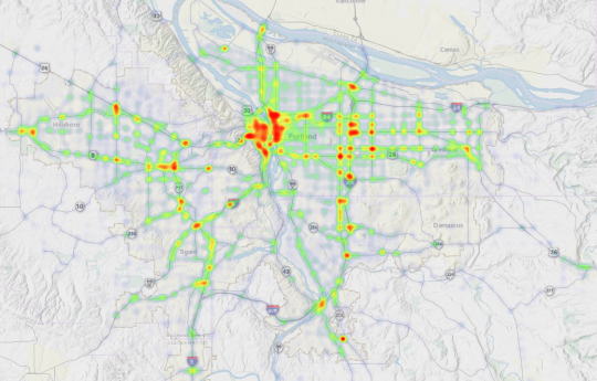
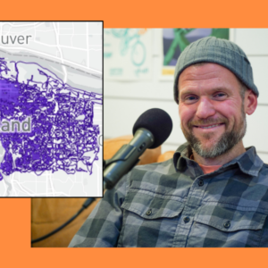
(Source: Metro Crash Map)
Last spring, the City of Portland created a fantastic new map of every fatality and major injury on its records for a decade. Now, regional government Metro has followed suit with a similar map that includes many other cities and unincorporated areas, too.
It’s not just an essential tool for understanding the context of future traffic collisions. (Should we be arguing about the specific circumstances of collision X, or does something seem to be inherently wrong with the street it happened on?) It’s also a source of some useful insights about road safety in Portland.
Half of reported collisions damage only property, not people’s bodies
The sheer amount of damage we do to physical objects by banging into them while going about our business is often forgotten.
When we talk about the cost of our road system, we don’t measure this. When AAA estimates the annual costs of car ownership, this isn’t included. (In AAA’s imaginary world, every new-car dealership would be thriving and every mechanic would be broke.) But when a car hits something, you can bet that someone is going to end up paying for it, no matter how rich or poor they are and what other more useful things they’d rather do with that money.
According to Metro’s statistics (visible in the upper left of their map if you check the various boxes), 53 percent of reported traffic collisions cause only property damage, and cars were the only vehicles involved in 99.77 percent of them.
Advertisement
There are lots of crashes downtown, but very few fatalities
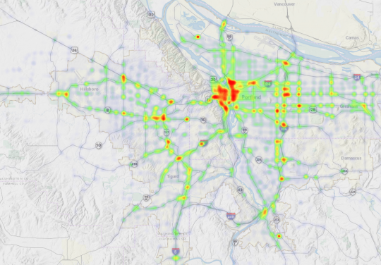
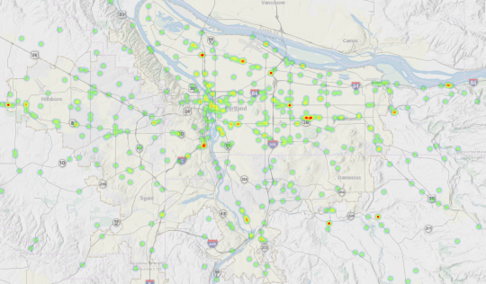
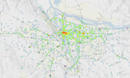
If you look only at fatalities in Metro’s map, the big downtown Portland blob disappears. Why?
The blob is there on the other maps not because downtown is dangerous, but because downtown gets lots of traffic. But if the blob vanishes for fatalities, that means that downtown is an extremely nonlethal area despite so many people coming and going.
What’s going on?
One of the less appreciated principles of Vision Zero as it was developed in Sweden is that in order to decrease fatalities and life-changing injuries, you sometimes need to increase the risk of non-fatal crashes.
That’s why things like narrowing traffic lanes, putting objects in the street and planting trees along curbs, which might have struck a 20th century traffic engineer as “dangerous,” can actually be good from a Vision Zero perspective. All of those measures make people more nervous about driving fast … so they don’t drive fast. Which is the single most important way to reduce fatalities and life-changing injuries.
Sometimes someone screws up, and sometimes they cause a collision. But if traffic is generally slower-moving, then the increased risk of a low-speed collision is a good price to pay for decreased risk of a high-speed one. At least, that’s the argument.
This map implies that if streets throughout the metro area looked more like streets in downtown Portland — short blocks, narrow lanes, ubiquitous jaywalking — we’d all be much, much safer.
Alcohol is involved in twice as many major car-car collisions as major bike-car collisions
Drunkenness (by either party or by both) is a much bigger factor in car-on-car collisions that caused death or serious injury (15 percent of such collisions) than in car-bike collisions that caused death or serious injury (6.4 percent of such collisions).
This is where the phrase “vulnerable road user” comes from. Impaired judgment and reflexes are often needed to seriously injure someone inside a collapsible steel box. Not so with someone on a bike.
People are vulnerable road users while walking, too, and Metro’s stats show that alcohol is involved with fully 28 percent of major car-on-pedestrian collisions. Presumably that’s because drunk walking is so common — much more common than drunk driving or biking. And though all such fatalities are horrible and drunk walking is often a bad idea, it’s actually a great thing that drunk walking is so much more common than drunk vehicle use.
There are lots of other insights, many of them locally specific, to be gained from a project like this. Feel free to share others below.
— Michael Andersen, (503) 333-7824 – michael@bikeportland.org



Thanks for reading.
BikePortland has served this community with independent community journalism since 2005. We rely on subscriptions from readers like you to survive. Your financial support is vital in keeping this valuable resource alive and well.
Please subscribe today to strengthen and expand our work.
I wish ODOT would think about reducing vehicle speeds on their inner Powell “safety” project (now in the planning phase). They’re considering just about everything but, including tree removal (what was that about last-century engineering?). They won’t even measure vehicle speeds, claiming (falsely) that if they do they’ll be compelled to raise the speed limit.
It’s just ridiculous.
Agreed. It’s one huge thing that could be done to improve safety that is virtually free.
I saw red at the open house for this project for a minute when the ODOT staff tried to explain to me that the main problem is that my neighborhood’s streets are too close together.
If ODOT’s going to maintain Powell as the Mt. Hood Freeway, then they should condemn or barricade off the too-close neighborhood streets.
If they’re not going to do that, this sounds like a major admission of guilt. They know that the existing constraints don’t allow for the type of stroad they’ve decided to engineer there. There is blood on ODOT’s hands.
Washington County says the same thing about Bethany BLVD. They’ve told us basically, ‘you don’t want us to do a speed study there, because if we do we’ll probably find that 80% of drivers are doing 40-45, so we should raise the speed limit’.
Raising the speed limit in a high crash corridor is not going to fly, politically. They don’t want to do the study because if they do, then they’ll have to confront the problem.
Wow, it looks a lot safer north of the Columbia River. 😉
You won’t die in a car wreck, but make sure to watch out for dragons.
drunk walking:
you seem to be saying that 28% of the time the pedestrian is at fault and drunk, but I think that the 28% is for all ped-car incidents regardless of who is drunk and doesn’t take into account who is at fault…
it’s my opinion that they misuse “alcohol involved” in that they’ll do a toxicology test on the ped and say that alcohol was involved… this wrongly suggests that the ped was at fault…
more likely that a lot of these “alcohol involved” incidents are not the fault of the drunk ped but rather the fault of the sober driver encountering somebody that’s not able to react quick enough to the illegal actions of others in order to avoid the incident…
if you stop taking action to avoid bad drivers then you will get hit…
Like a sober pedestrian is going to leap out of the way? Good luck.
I definitely don’t mean to be implying that drunk pedestrians are at fault for their injuries. Sometimes they are but this map doesn’t say anything about who’s at fault. I totally agree with your analysis of what’s likely going on.
I’m just saying that car-pedestrian collisions are much more likely to involve someone who’s intoxicated than car-bike or car-car collisions, according to these statistics. Presumably that additional alcohol use is coming from the people walking, unless there’s some reason that drunk drivers are drawn specifically to people walking more than they are to other moving targets.
This suggests that drunk walking is more popular than drunk driving or drunk biking, which is great news. If you’re drunk and heading home, definitely choose a mode that won’t hurt someone else.
“[Things] which might have struck a 20th century traffic engineer as ‘dangerous,’ can actually be good from a Vision Zero perspective. All of those measures make people more nervous about driving fast … so they don’t drive fast. Which is the single most important way to reduce fatalities and life-changing injuries.”
The thinking that people would drive carefully reminds me of the mindset football would be safer without helmets. Both that sport and the automobile have a rich history in the era before safety equipment. It was nothing less than carnage. People were more than happy to tolerate it.
The cliche is true: it ain’t about the player, it’s the game.
The analogy is flawed. Football helmets and car safety features are about protecting the player and the driver. In the football example there is no good corollary to vulnerable road users (VRUs).
Car safety features may make it less likely that occupants of the vehicle will be hurt in a crash, but they do nothing to alleviate the traffic violence against VRUs. In fact, the theory of risk homeostasis suggests that drivers will be emboldened by additional safety equipment so as to keep their personal risk invariant. This more aggressive driving increases the risk to VRUs.
The football argument is probably most relatable. Helmets are not just protection for the user, they are also weapons used against other (vulnerable) players.
We can change the equipment and slow it down, but it’s still the same game and people are going to get hurt.
Rugby does pretty well without helmets.
It is more accurate to say that rugby isn’t played by a population of 400 million people with a league of 32 professional teams drawing 80+ players every year after working their way up from literally hundreds of even larger college teams.
You’re right, but only on the literal level. Europe, Australia, NZ, South Africa all sport world class teams, and rugby is played in the US at the amateur and college level. It gets a lot less attention here than American football, but I would guess that the population playing rugby vs. American football is comparable, if not larger.
But many rugby players wear rubberized helmets, as do many Aussie Rules players, and (increasingly) soccer players (notably goaltenders). A few weeks ago, an ODOT guy told a meeting that Powell (aka US-26) is “the main highway to Madras” and therefore, auto traffic must take supreme priority there. Without using the words, he basically argued that Powell is a Homeland Security corridor, where bikes basically shouldn’t go. If this is true, than bike lanes on Powell are dead. Taking bikes off Powell also means no bike / car collisions there, except maybe at stop lights. And it also means the Springwater Trail must be the E-W bike / ped thru route across the Eastside, not Powell.
Does anyone west of 82nd even use Powell to get to Eastern Oregon? Even when I lived on the west side, it was always faster to take I84 to Gresham to access 26.
Side point, but – wrong, Mike. The headgear that some rugby players wear are called scrum caps. They are not “rubberized” and they are not head protection. All they do is protect your ears so that you don’t get cauliflower ear from repeated rubbings in the scrum. They don’t protect your head beyond any superficial bumps and scrapes, and aren’t advertised to. Rather, rugby maintains head safety through the rules. You may only tackle a player below the shoulders, you must wrap them with both arms, you must maintain the wrap as you take the player all the way to the ground, and you may not dump, spear, or tip them to 90 degrees or beyond. Violating any of these incurs penalties and/or yellow/red cards. Because of the rules, tackling in rugby has a definite required form to it that protects both players (both tackler and tacklee) much more than in football.
Next link these maps to the police reports and they will be truly useful for planners and engineers and safety advocates.
…and then a layer as to how the legal case was felt with (out of court settlement, fine, jail time, no case, etc.)
damn fat finger typo…”felt” should have been “dealt” in above
How are major injuries defined and where does the data underpinning these maps originate? My neighbor was hit by a bus at NE 21st & Multnomah and lost her leg in approximately 2008 or 2009, but that incident is not listed on either of these maps. The Portland map says there were zero serious injuries at that intersection from 2004 through 2013, and the Metro map shows nothing, either, when I search all its injury levels for 2007 through 2013 at that intersection. It’s hard to accept the data as valid when something so significant is missing.
I’ve found more than one incident (including fatalities) that I’ve known of being off a block or two on the map.