(Images from a city engineer’s design dated April 2015)
Well, this would definitely be odd if it happened.
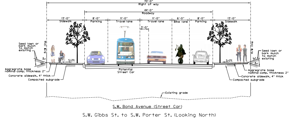
Despite a continuing gusher of evidence that adding some sort of vertical separation to bike lanes makes them much better at getting people to actually ride bicycles, the City of Portland was, as recently as April, drawing up “preliminary” plans for an entirely new street in the South Waterfront that had a bike lane painted into the door zone of a road bed.
Two days after we emailed him about the plans, city spokesman Dylan Rivera said the sketch (which is dated May 5, 2015 and lists April 2015 as its “date approved”) was “per the 2009 city council approved street plan for the area” and that “we are considering other options.”
The street in question is Southwest Bond, and it’s supposed to create a new weaving direct connection between the South Waterfront’s currently developed residential area, through the yet-to-be-developed Zidell shipyards and into the Riverplace area just north of the Marquam Bridge.
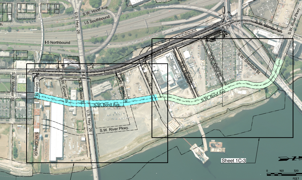
Once it’s built, Bond will also create the first major intersection on the west landing of the new Tilikum Crossing, so it’s likely to attract plenty of north-south bike traffic connecting to the bridge.
Advertisement

Another oddity about the April design for Bond: it would have apparently offered southbound bike traffic a choice between either a general travel lane or a sidewalk.
All of this wouldn’t be a big deal if not for the fact that the street is being built completely from scratch. So there’s almost no cost difference between a raised bike lane and one in the road bed. There isn’t even any topographic constraint; the plan hammered out by property owners and the city is to bury the entire area in soil and concrete, creating an entirely new slope, as shown here:
The only real obstacle to including state-of-the-art bike lanes in this future dense urban area is the amount of road width required.
Even more than the nearby Southwest Moody Avenue, Bond offers a rare opportunity to build a street completely from scratch in the middle of a metro area. Since the South Waterfront would have to put a third or more of its trips on bicycles for the city to achieve its transportation goals — and since the neighborhood is probably always going to be annoying to get to in a car no matter what — we’re eager to see how the city weighs these issues as it considers its forthcoming “other options” for the street.
“The preliminary design you have found implements the 2009 street plan for the area, which was approved by City Council after substantial public involvement,” Rivera said. “Six years later, now that the area is closer to redevelopment, we are looking at more detailed designs and trying to take into account the latest best practices for safe access for all road users. We’re not ready to discuss a timeframe for potential refinements, but can keep you posted when we know more.”


Thanks for reading.
BikePortland has served this community with independent community journalism since 2005. We rely on subscriptions from readers like you to survive. Your financial support is vital in keeping this valuable resource alive and well.
Please subscribe today to strengthen and expand our work.
“it’s supposed to create a new weaving direct connection ”
2nd humorous note after the Unipiper icon.
the odd thing to me is that they’re designating 2 full lanes to motor vehicles… you’d think they would design it for none, or at least 1 shared lane for both directions chicane style…
their plan is not a vision of the future with the majority of the road given over to privately owned motorized living rooms…
4 Lanes for motor vehicles. Removing the on street parking would remove the door zone problem.
The elimination of Zidell shipyard will facilitate the connecting of the Greenway Trail which is required when riverfront real estate is developed. Therefore there will be 3 elaborate bike lanes roughly parallel about 1/4 mile apart. Considering that it will be “annoying to get a car into” anyway, is there really a need for this showpiece? I like separate bike lanes as much as the next rider, but more pavement in an exercise of redundancy might not be the best use of resources.
Given that the high density of this area means that hundreds of people, including children and seniors, will live and/or work and/or visit on each block of each street, yes, I think it is worthwhile to have high-quality bike connections on each one.
*thousands of people 😉
The Development Agreement the City struck with Zidell this year commits them to building the Greenway between the Marquam Bridge and the Ross Island Bridge by 2022. The section between recently built greenway and the Ross Island Bridge isn’t going to happen until at least 2025, and maybe never. The Zidells plan to keep operating on that site as long as there is a market for their barges.
The new road we’re talking about also wouldn’t be built until the barge site is gone, so it’s not as if Bond would be available until the greenway is complete. That said, I’m all for all 3, just wanted to clarify that.
Bond is going to be built in phases, and currently has funding allocated to it from the Urban Renewal Area. Phase 1 is from Riverplace to SW Woods, Phase 2 is from SW Woods to SW Grover, and Phase 3 is from SW Grover to the existing SW Bond / Gibbs intersection. Phase 1 and 2 might be built separately or concurrently, but the City has committed to getting both done by 2018. Phase 3 *might* have to wait until the barge operation is gone, but there is also talk of designing the street around it.
You can see the phasing and map on pages 43 and 50 of this PDC document – http://www.pdc.us/Libraries/Board_Resolutions/Resolution_7117_PDF.sflb.ashx
A protected bike lane wouldn’t require more pavement, but it would require a design that dedicates slightly less space to to cars. Reducing one of the lanes to 10 ft, and one of the parking lanes down to 7 or 7.5 fit would provide the space needed for a protected bike lane.
And because the street will be newly constructed, the costs difference between the 2009 design and a more contemporary version are essentially zero.
Given that I don’t think TriMet has any plans to run buses along Bond, is there any disadvantage to reducing lanes to 10′?
Their drawing shows a ‘potential streetcar.’ Engineers like having a little extra breathing room in case parked cars extend beyond the parking edge so the streetcar isn’t blocked (a too common occurrance on SE Grand).
If they make moody/bond a couplet and move the northbound streetcar to bond then to avoid the parked cars blocking the streetcar they could have the streetcar running next to a bike lane instead of parking. Since nothing is built there yet they can make sure there aren’t any curb cuts on that side of the street. Add in frequent crosswalks so freight can easily be wheeled over from the other side. Add in floating transit stops and painted rumble strips/crosswalks to make clear that cyclists should yield to pedestrians heading to/from the streetcar.
If the street is being built from scratch, why can’t the total roadway width be whatever is necessary to accommodate all modes? Protected bike lanes plus traffic lanes plus parking plus streetcar.
Streetcar isn’t needed there. SW Bond needs to be a narrow street for cars.
I’d be surprised if the streetcar winds up moving to Bond. The plan back in 2009 was to have it running on a Bond / Moody couplet. That was when the streetcar was still on a single track temporary alignment on ballasted track (https://goo.gl/maps/xiHxW), and before the current configuration of Moody was designed. Now that Moody has been rebuilt I think the plan is to keep the tracks on Moody, but make the northbound lane transit only.
Since the marginal cost is so low, it’s worth doing right.
They are continuously building and refurbishing barges there – they just launched a new one last week. The Zidells seem to be offering a lot of property around that area, but the barge facility, like Ross Island Sand and Gravel, will be there for a long time to come.
“Yes, apparently city engineers sometimes use the Unipiper to designate bike lanes.”
Unicyclists need their own dedicated lanes too. Currently there is only one in the entire city, on NW Cornell Road.
Discrimination against tricyclists!!
Unipiper Rules
The trick with protected lanes is to get the intersections right. Otherwise, they should just use sharrows. I already take the lane all the way up Bond unless I’m window shopping (there’s two lanes signed 20mph and only 3in of bike lane past the tip of an open car door.)
If we had our priorities straight, moody and bond would both be streetcar + bike only. Maybe one “protected” lane somewhere for 2-way car traffic. Why are we building so much parking?
The new section of Bond is going to have very few intersections, so that’s less of a concern that it is on other roads.
Too much parking! The city is expected to pay for the mobile living rooms that are overflow from the 10 story parking garages.
Are they not metered?
Technical question here —
I always considered a “Door Zone Bike Lane” to be a 4′ wide bike lane, between a line of parked cars and moving cars. Current standards do not allow these to be put in without a design exemption.
And a 5′ bike lane to give barely enough space, as long as there aren’t a lot of buses and trucks on the roadway. This is the basic minimum bike lane in the Oregon Highway Design Manual, and nationally.
And a 6′ bike lane, like the one pictured above, to be a standard, reasonable bike lane. Nothing special, but if there’s not a lot of cars and speed limits are slow (as is the case here) a fine facility for the 8 to 80 constituency.
(Even though an extra 1′ might not seem like that much, it creates a clear path for bikes, with about 9″ of wiggle room on either side in the worst-case scenario — going between a wide car door on a wide car and the rear-view mirrors of buses. (And at least 18″ of wiggle room under non worst-case scenarios). (I haven’t actually measured this).
Does anyone have more info on the DZBL term? Like who coined the term DZBL, and what facilities they were describing to use it?
Just curious. We can and should do better for a main bike arterial between SE Portland and downtown, but we should be using terms correctly when we have the conversation.
Ted Buehler
Examples:
4′ Bike Lane:
Tillamook, in Hollywood District
https://goo.gl/maps/aT4kx
NE 43rd, Hollywood District
https://goo.gl/maps/FM8jJ
NE 57th near Fremont
https://goo.gl/maps/d6etN
Marine Dr near Portland Yacht Club
https://goo.gl/maps/9TQI8
5′ Bike Lane — I’ve measured a lot of bike lanes, I *think* these are 5′
Interstate Ave
https://goo.gl/maps/i5kAr
NE Broadway
https://goo.gl/maps/4iPFN
NE Glisan
https://goo.gl/maps/6InAZ
6′ Bike Lane — (also just by my observation)
Vancouver Ave near Shaver St
https://goo.gl/maps/7jPEf
SE Hawthorn outside Clever Cycles
https://goo.gl/maps/MLd0Q
& some other PBOT installed lanes designed post 2011, I don’t recall where I’ve seen them though.
IMO, any time a bike lane is to the left of a parking lane, it’s a door-zone lane. Nothing is instructing new riders to stay out of the door zone. Not sure what speed you consider to be “slow traffic”, but IMO even a six-foot bike lane between parked cars and moving cars is hardly an 8-80 facility.
If you consider 4′ to be the door-zone width then we are effectively installing one-foot bike lanes at a minimum. This is unacceptable.
“…Nothing is instructing new riders to stay out of the door zone. …” adam h
Nothing, except common sense and a little helpful knowledge from people experienced with riding in traffic situations, to those new to biking.
It’s not that complicated to figure out how to ride a line down a bike lane to avoid the door zone. Doing so means people riding safe on bikes often may not be riding right down the center of a given bike lane or in the bike lane at all, but rather, to the left of the line designating the bike lane, or fully in the main travel lane. If city planners and traffic engineers don’t know this already, they should.
Those feathered edge grade elevated bike lanes can’t offer much real protection from motor vehicle traffic to people riding bikes. Motor vehicles can roll right up that edge and onto such bike lanes with hardly a rumble.
It”s easy enough for us to say that avoiding the door zone is simple and obvious, because we all ride regularly. Someone who is just starting out riding may not know about the door zone until they “figure it out” by almost being doored. The learning process of urban riding shouldn’t involved almost getting hurt.
I thin there’s an extensive lack of awareness of basic procedures for avoiding the door zone; I’m concerned it’s not just newbies to biking that aren’t aware, but many people that drive…people that enforce and administer the law…people that design the bike lanes.
The word just has to get out there somehow, because it’s very unlikely that bike lanes with buffers wide enough to keep the center of the bike lane sufficiently outside of the door zone are ever going to become extensive throughout the bike lane system.
I disagree with your implied arithmetic. The widest door zones extend out twelve feet from the curb. Sure, it would be nice if everyone drove tiny cars with short doors, but we must consider what is allowed (and encountered). The drawing lists eight feet for parked car storage and six feet for the door zone bike lane. Yes, it’s still a dzbl because eight plus six is only two more than twelve. It’s actully worse because the eight-inch bike lane stripe takes up part of this space as wellSure, many cyclists can fit in this two foot (minus) space, but that leaves no margin for error. And yes, the Oregon design standards, as well as AASHTO and NACTO are wholly inadequate.
There’s three kinds of riders:
1. Those who ride in the door zone but haven’t won the door prize yet.
2. Former riders who were type 1 until they got enough miles in the saddle to have won a door prize.
3. Riders who don’t ride in the door zone. Among those few of us who have very high mileage, I’ve never met one who rides in the door zone.
With “advocates” calling for implementations that are the number one cause of cyclist death/injury in urban settings, at least according to the SFBC, who needs bike haters?
Agree, it should be illegal to encourage new bikers to ride in the door zone with paint.
Proud say I’m in group 3. Even in bike lanes I ride the white line. It’s just common sense that traffic behind you is much more likely to see you than the traffic/cars in front of you.
Which why I like the greenway markers. They are the only marker/signage which designates that bicycle riders stay out of the door zone.
Of course like all signage it doesn’t seem to work well. They seem to be beyond most people’s knowledge base because 99% of bicycle riders don’t follow the position literally spelled out for them.
A few more 4′ bike lanes, the “true” DZBL.
SE 26th
https://goo.gl/maps/7SisG
https://goo.gl/maps/U5sTP
SE Water? (I rode this last night, it sure looked narrow then, but looks more like 5′ on Google StreetView.
https://goo.gl/maps/QDzZA
FWIW,
Ted Buehler
How can you miss Homer Simpson parking his lavender Mini Cooper?
Saw that, half expected the wheelchair user to be poppin a wheely.
Bond would be a great place to test the city’s first protected bike lanes with protected intersections.
Unless it is a tunnel or a bridge, there really isn’t such a thing as a protected intersection.
The road needs to be very narrow for cars. Very narrow. Perhaps a “shared road” without yellow stripes.
Plus, the $treetcar needs to stay on Moody. The outer parts of Portland are long-overdue for overhauled roads in regards to public transit.
the “design” link in the first image caption is broken, it’s asking for an ftp login…
FTP always asks for authentication. Most web browsers try an anonymous login first but some might not. If your client is asking for a login: use the username “anonymous” and the password is usually blank, “guest”, or an email address like “user@host.com”. 99% of the time it works every time.
Will the extension of Bond Avenue require the destruction of the OHSU Commons pedestrian plaza? It certainly seems so based on those plans.
Portland: taking away space from people walking for people driving and “throwing a bone” to people biking by giving us a door-zone bike lane.
Don’t forget the constant hand-wringing regarding just how PDX managed to totally stagnate in terms of bike usage. How could this have happened with all the oh-so-nice talky-talk?
The ped plaza surrounding the Aerial Tram should remain and Bond between Gibbs and Grover should also be made pedestrian-only. It would make a great place for the food trucks to go once they are relocated from the Zidell property.
I got an answer from project manager Richard Browning. In short, yes, the pedestrian plaza will be destroyed and open to cars.
It’s sort of odd that the city has an opportunity to build a complete street from scratch..and yet gives barely lip service to bikes. Odd.
They did it on the other segment of SW Bond, which is door-zone bike lane all the way and was built within the last decade. Get involved with BikeLoudPDX or the BTA or Bike Walk Vote if you want it to change!
bikeloudpdx.org
If parking is to the right of the bike lane, I wonder if it makes sense to paint a 1-foot wide bike lane, then a 4-foot ‘buffer zone’ between the bike lane and the parking.
With cars, the lines mark where the operator needs to keep the wheels in order to keep the whole vehicle inside the lane. & the wheelbase is about 95% of the width of the vehicle (except mirrors)
With bikes, the vehicle extends at least 16″ to the left and right of the wheel.
So, it makes sense for cars to strip the lanes as a “channel,” and keep the wheels in the channel to avoid conflict.
With bikes, you need to keep your wheel about 18″ away from each side of the marked channel to avoid conflict. This is most obvious on a 2-way bike path with a yellow stripe down the middle. Somehow people have the idea (fast roadies especially) that you are entitled to ride with your wheels right along the yellow line. But this doesn’t work, obviously, if two folks have the same idea and are going in opposite directions. Even if all parties have their wheels on their own sides of the yellow line, they’re still going to have a head on collision because the vehicles extend out 18″ to the left of the wheel.
So, I would think it could make sense to lay a few extra stripes in the bike lane. If it’s only 5′ wide, put a stripe on the right hand side about 2′ out from the parking stripe. This is more expensive to build and maintain, and would provide a slick riding surface in the part of the bike lane you’d want to ride in where there are no parked cars, etc. Maybe just align the arrow in the “Bike Lane” stencil to be on the left side of the bike lane, to give a little more direction…
Ted Buehler
IS THAT THE BAGPIPE DARTH VADER UNICYCLER?!!?!
Angled in parking only on one side of the street.
Consider interchanging the bike lanes with the pedestrians. Perfectly secure and separated bikes, and pedestrians who can cope with the door zone interactions because they happen at relatively nslow speed.
Since this new street is going to be downtown, why not just have traffic follow the established rules and give bicyclists the power to “take the lane”? Adding bike lanes to just some of the streets downtown is just going to add confusion and probably frustrate drivers when cyclists continue to ride in their lane, adjacent to an empty bike lane. How about seperating the bike lane from the road altogether? I know that when I’m on a bike I feel safer on the waterfront, the springwater corridor, the esplanade and on the 205 bike path than I do in any of the in-road bike lanes around town.