(Photos: M.Andersen/BikePortland)
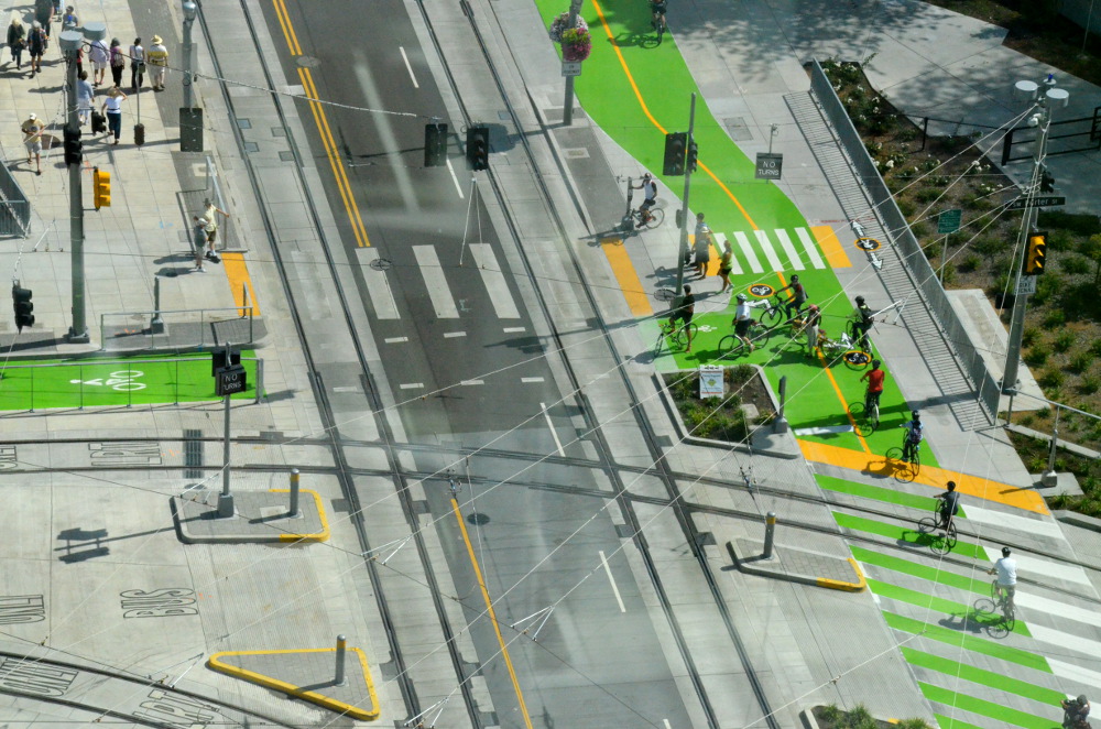
Just in time for Tilikum Crossing’s public preview last weekend, TriMet and the City of Portland unveiled a new design for the main street leading to the South Waterfront.
In two words: It’s fantastic.
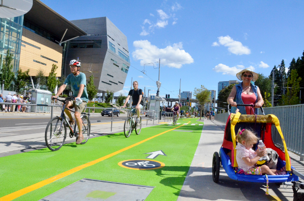
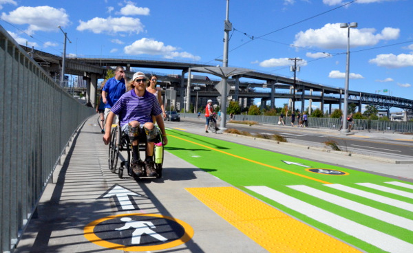
Gone: the confusing weave that sent people biking and walking across one another’s paths right below the Ross Island Bridge. Both bike lanes now remain on the curb side of the Moody sidewalk throughout, with people walking closer to the western hill side. The trees on the Moody sidewalk now serve as part of the buffer between people walking and biking rather than the buffer between the two directions of bike traffic, which is more intuitive and helps keep everyone out of each others’ way.
Upgraded: the lonely Hawthorne Bridge-style circles that mark which mode is supposed to go where. Backing them up in the most visible way possible: lots of textured green pavement coloring that makes it impossible to mistake the bike lanes’ route in the most complicated part of the street, just across from the bridge and the new OHSU-OSU-PSU Collaborative Life Sciences Building.
Moving the bike lane away from the hill also mitigates an awkward bend around a freeway support pillar further north on Moody.
Almost all of the $310,000 for these changes came from TriMet. That’d make it one of the most expensive bike-focused projects ever built in Portland, but it’s pocket change in the $1.5 billion Orange Line — which, as we reported in March, finished tens of millions of dollars under budget.
Why was the biking-walking “weave” on Moody in the first place? TriMet spokeswoman Mary Fetsch said it was because the city and TriMet had wanted to avoid sending bike lanes in between the sidewalk and transit stops on Moody — a design that’s widely used in other countries and cities but only exists in a few Portland locations.
Advertisement
However, the new design handles this nicely, getting the attention of people biking by prompting them to bend around the station and creating a marked crosswalk where, presumably, people walking have the right of way.
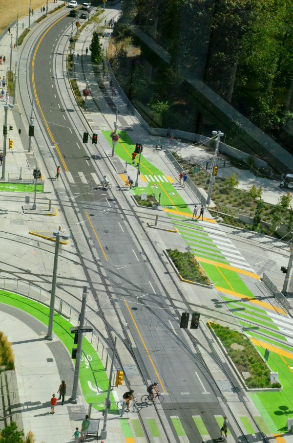
One aspect of Moody’s new design troubled me: the amount of time that north-south foot and bike traffic gets a red light at the bridge landing. Obviously red lights here are important when bus, light rail and streetcar traffic is crossing Moody. But the signal at Moody and the bridge also gives north-south traffic a red light every time someone gets a green light to cross Moody on foot or bike, which doesn’t seem necessary and threatens to create a sense that the signals can safely be ignored — which, of course, they can’t.
If there’s no east-west traffic detected across Moody, the light at the bridge landing is always green in the north-south direction by default.
Another big issue on Moody will be the length of the traffic signal for people crossing Moody coming on and off the bridge. It’s currently very long north-south and very short east-west, which will be frustrating to many people on bikes and seems likely to lead people to ignore the signal. During rush hours, when many people are likely to be heading eastbound from the Moody protected bike lanes across the bridge, the long signals seem likely to lead bikes to back up across the bike lane. You can see a little bit of that starting to happen in this photo from last Sunday’s bridge preview day:
Hopefully TriMet and the city will continue to treat those signal timings and other details here as works in progress.
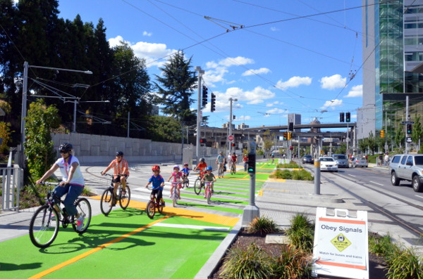
Generally speaking, though, it seems to me and to the people I’ve talked to that anyone who uses Moody by bike or foot is likely to be well-served by these changes. John Landolfe, the transportation options coordinator for Oregon Health and Science University, said Friday that he’s a big fan of the new design.
“We submitted recommendations based on our observations of how Moody was used and feedback from OHSU commuters,” Landolfe said. “We’re delighted that TriMet and the city have opted to fast-track safety improvements ahead of the opening of the new bridge. … This street serves not just OHSU but the larger community. We want people to feel safe as they travel by bike, by foot, by rail or road.”
“Improvements generally don’t come as fast as you want them to,” Landolfe said. “This time we got it.”
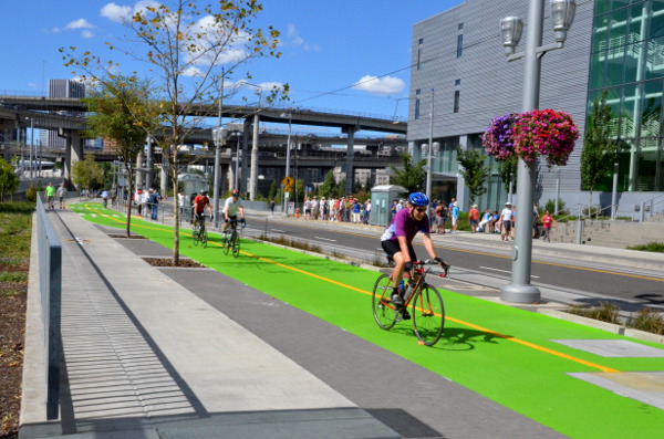
Obviously there are lots of unique things about Moody that make it relatively easy to have such high-quality bike facilities there. There are no driveways, no conventional intersections and no on-street parking on this stretch. There’s very little commercial activity (yet); in many ways it resembles a short off-road path segment, even though this is part of a city street.
But that shouldn’t detract from the credit that the city, TriMet and other involved parties like OHSU deserve for making this as nice as it is. It’s simply the most intuitive, comfortable, low-stress set of bike lanes in the city. With the free bike valet at its south end, it already deserves to be a stop for every Portland bike tourist; this half-mile of first-rate bike infrastructure should be held up as a model of how well Portland can do these things when it sets its mind to it — and when it’s willing to learn from and correct its mistakes.
If all goes well, that’ll continue on Moody and elsewhere.
“I’m excited, but it’s of course a wait and see,” Landolfe added. “There might be future improvements too.”


 bike lanes on N Willamette")
Thanks for reading.
BikePortland has served this community with independent community journalism since 2005. We rely on subscriptions from readers like you to survive. Your financial support is vital in keeping this valuable resource alive and well.
Please subscribe today to strengthen and expand our work.
In keeping with today’s weather, I’m going to rain on the parade a bit here.
This implementation would fail by even the standards of California. Here’s a few of the requirements for such an installation down south (all from the CalTrans Highway Design Manual):
Fixed objects (light poles, signs, trees, etc) cannot be placed closer than two feet from the edge of a bike path.
There must be five feet of separation between bike paths and adjacent pedestrian facilities.
When there is an adjacent fence or railing, there must be a solid white stripe two feet from the obstruction to minimize incidental contact. (This is because those objects do narrow the useful pavement for bikes.)
Bike paths not on a structure require a minimum two foot shoulder with three preferred.
So, if this is the best we can do, we’re certainly in a sorry state, pun intended. It’s almost like there’s a plot to make lots of really lousy infrastructure so that the public will embrace mediocre compromises later on. Just look at the pictures where a single person is blocking the pedestrian space and also notice how difficult it would be to pass slower cyclists if we ever succeeded in moving past 6%. Maybe that’s the point: to design in such a way that we will never get over 6%.
wait until the first cyclist blows the cross-traffic light and gets run over by a MAX train..I’ve ridden Moody every day for the past 9 years and while the facility is better than most, its far from perfect. pedestrians still don’t seem to get it either.
Then we might finally get the railroad crossing gates that they should have already installed.
agreed fully. the DOT staff just left the area. I already watched some guy on a bike blow the light this morning on my commute.
I’m all for separating bikes from pedestrians, but 5′ of separation (!) is beyond excessive. At a certain point a street gets too wide to be a pleasant place to inhabit, and using ridiculous California engineering standards contributes to that. As an example, the streets in downtown and our older neighborhoods are generally pleasant places, that follow the rules of thousands of years of urbanism. 122nd is not a pleasant place to be due to its excessive width, and still wouldn’t be if it went on a road diet and all the car lots were redeveloped with mixed use buildings.
Well said. 5′ separation would make 90% of cycling infrastructure in Europe, such as the Netherlands, illegal.
Exactly. And why would we follow California standards on anything?
Europe has much higher standards for driver licensing including real driver education. Europe has much stricter standards for driver compliance with traffic laws including much stricter standards for DUII. As a result, European drivers can be trusted to do a better job driving so the design standards can be lower. Look at the fatality rates for vehicles, the US rates are 3x those of some European countries.
Unless you’re talking about bicycle drivers, what do driver standards have to do with what separation distance between cyclists and pedestrians is appropriate?
Europe may have stricter DUII standards, but driving after drinking is very common in many European countries. In some countries (Germany, for example), people take driving much more seriously than Americans do. In others, not so much. In some places, they make American drivers look the model of prudence and caution.
Mellow out or you will pay
California Uber Alles!
I’d rather our cycle tracks follow Dutch standards, not California standards.
Speaking of Dutch standards, how about replacing neon green thermoplast with more natural appearing colorized asphalt. The thermoplast peels off and deteriorates quickly.
Because tearing out the perfectly good concrete cycletrack and pouring a new one with colored asphalt would be very expensive?
I believe a thin layer is poured over existing asphalt. And it is best done during resurfacing projects, not after the fact. And I’m guessing it is actually cheaper than the material used now (when done on large scale coloring projects), particularly when considering durability. I think I have seen it used in the Bend area.
Yes, they put normal asphalt down first then a layer about 1/2″ thick of colored asphalt is put down. May have been thicker—can’t remember precisely, but it’s fascinating to watch the process of rebuilding an entire street/sidewalks/bikeways over a few months time.
Because green is the standard color and going off standard is a liability?
You’re starting to catch on. There is no point in catering to dedicated riders (like me) because it won’t take any cars off the road. Showcase projects for the other 94% build a critical mass of support for more improvements; glaring problems with safety and equity can just wait until that happens—if ever.
And if bike lanes are a sign of neighborhood gentrification, these cycle tracks are a sign of bicycling gentrification: the “rent” just went up, get ready to spend more time and frustration or move along. This way to the Hyundai leasing office…
“There is no point in catering to dedicated riders (like me) because it won’t take any cars off the road.”
Not true.
There are certainly people out there who now drive cars who have the full potential to become “strong and fearless” or “confident” bicycle riders. It might be 1 in 20 of all car drivers. Or 1 in 100. Either way, getting those cars off the roads at rush hour would alleviate the growing car congestion decried by The Oregonian.
http://www.oregonlive.com/portland/index.ssf/2015/08/its_not_your_imagination_portl.html
These potential converts are missing something necessary to take the couple of steps to get there.
It might be decent bike parking at their workplace. It might be an increase in the cost of parking at their workplace. It might be a friend introducing them to the pleasures of bicycle commuting.
But, more likely, it’s sections of unacceptably dangerous infrastructure between Points A and B. And, sections of unacceptably SLOW or CIRCUITOUS infrastructure between Points A and B. Safety and speed. You need them both to get folks to switch. That’s how Portland did it in the 90s (when all bicycle facilities were fast, if not direct, because of low bicycle traffic volumes).
So, PBOT should have a vested interest in making routes that are safe, but also direct and fast.
Just saying,
Ted Buehler
Yes, it needs to be safe and efficient. Enabling fast biking might be more of a transitional crutch where eliminating stops would be much safer without lowering average speed. I often find myself thinking “does Portland really want me to ride a bike?” — generally at a stop light, and there are a lot of these. Driving is cheap and easy and the people who designed the infrastructure actually use it all the time. Can we afford to get PBOT an electric bike?
Ahh, bikeportland. The place where we can come and see armchair activists complain about world class bike facilities.
You would still complain even if it were the best bike facility in the universe.
I would rather complain about the Pac NW’s generic use of the word “rain” to describe main differing types of liquid water precipitation.
There are so many (National Weather Service Glossary) varied and descriptive words for liquid precip. Professional and colloquial.
What’s worse is if you’ve experienced actual rain or a hurricane what locals call “rain” here amounts to standing downwind of the misting nozzle that plant nurseries use to gently water seedlings.
I can’t honestly expect that everyone will know what rain type 17 is but vocabulary differentiation would be useful.
(this rant was mostly in jest…. mostly)
single-file bike lanes that allow no passing room…
narrow sidewalks that don’t allow couples to pass each other…
beg-buttons to cross unless you’re driving…
the tall mock-up at the top shows people crossing Moody and the bridge landing simultaneously, which to me was great to allow all modes to cross both directions while motor traffic was stopped… but you state that the lights actually take turns alternating…
it’s certainly not fantastic, but it’s decent…
when I use it I’m sure I’ll be failing to obey traffic control devices in favor of what actually works…
it’s a confusing mess of poles and traffic control lights…
given all the available space and technology I’d still consider this area a fail… I don’t see that we’ve learned anything…
You’ll figure it out soon enough. Lucky enough for me, since I’m a fred, this will add more distance to my commute since the bridge is facing away from downtown.
They aren’t single-file bike lanes. Did you not see the photos in the story with several people riding side-by-side?
Portlanders need to learn to cycle closer together, its really not that hard. Europeans would laugh at us.
the only person riding side-by-side is with a kid, and they’re both hanging out over the bike lane…
let me quote mark wagenbuur of bicycle dutch:
“The standard width for one way cycle paths in the Netherlands is a minimum of 2.5 m ( 8′). Wider ones are not uncommon. For bidirectional use the minimum is 3.5 m (11 ‘), but most modern cycle paths are 4 m (13 ‘) or more.”
i also think it’s not appropriate to expect new and/or inexperienced people on bikes to ride like dutch cyclists who have been riding their entire lives. this is the “infrastructuralist” equivalent of john forester arguing that all cyclists should ride at 18-20 mph (to lessen the speed differential with car traffic).
And how wide is Moody?
“this is the “infrastructuralist” equivalent of john forester arguing that all cyclists should ride at 18-20 mph”
Good point and well stated.
Yeah, but they aren’t that wide in the central city of say Amsterdam, they are closer in width to Portland. And you will get 3-4 people riding side-by-side on a 7′ – 8′ wide bike lane there.
That math is giving me trouble with my assumption that 24in is a somewhat narrow handlebar in Amsterdam. I found a 21in wide “dutch style parallel bars”, but you’re still going to be knocking knuckles even if this shape helps keep your elbows in.
If you’re both going slow and about the same speed it’s not a big deal to bump slightly. Congestion is only a headache when there’s some asshole who tried to whip around everyone when there isn’t room. That aggressive behavior seems more common among cyclists in the US than what I’ve seen in Europe.
Hope you can give us further information about how to safely navigate from Moody to downtown. I bike commute from Eastmoreland to Max at Goose Hollow and am not at all clear how to get in reasonable safety from the west end of Tlikum further north and west.
The issue of traffic lights being defaulted to facilitate N/S automobile traffic is a problem on the east side cycle approach as well. Long waits at 8th, 11th, and 12th and no stop sign for auto traffic heading south on Water at Carruthers. LOTS of southbound auto traffic there in the evening as this has been discovered as a way to avoid the 99E viaduct.
Exciting to have the bridge finally open, hope that we get the safety and convenience we need.
Yeah, there is a spot that would connect things nicely. But it’s closed to bike traffic. Might as well lease a Hyundai.
To get to downtown from the Tillikum Bridge, head north along Moody, cross Sheridan, head north along the path underneath the new viaduct. Cross SW River Parkway. You can now either go west along SW River Parkway which gives you access to SW Harrison and PSU, or head north along the path to SW Harbor Way which continues to the Riverfront Park.
Uh, let’s not go to negative town. This is pretty good.
I agree. This is going to be nice to ride on during the rainy season when it will be open.
Christmas morning, downtown and the waterfront.
The lack of cars is unbelievably refreshing.
Any success here may be solely due to ODOT’s lack of participation.
Moody is great to ride in and likely Portland’s only example of world-class cycling infrastructure. It even features concrete islands, waiting-to-turn areas, and bike signals like Dutch cycle tracks. Moody is evidence that we can design great cycling infra and we should use this as an example of how to build cycle tracks in the future. Let’s use this design on Naito.
Parts of it are good. It might be the best separated bikeway Portland has built, but it barely has any intersections and all of its intersections have problems. Try coming in from the south, where you first have to shift over a block to the door zone bike lane on Bond (making a left with fresh-off-the-freeway traffic), then get doored or cut-off at a very busy curb zone on the way back to Moody. If you make it to Moody, figure out how to use the jug-handle after dancing with pedestrians, your reward is a poorly timed light with a beg button while you wonder if they’re serious about that “no bikes in lane” sign. Same story with every intersection: getting onto the bridge, off the bridge, crossing Sheridan, later at River Parkway — every one is a stop light, even if it’s a little red bike, it’s still red, and generally for no cross traffic. There are red lights on the bridge for a pedestrian crossing? As if to say that people on bikes cannot be trusted to yield at a crosswalk (see “simultaneous green” for world-class.) All the while, you’re really just sharing a sidewalk with pedestrians who don’t always know where they are supposed to be or bother to look around them. And lookout if any of these driveways start seeing more activity (or with more development and more driveways.)
I would be interested in a detailed comparison with other infrastructure. My impression is that we’ve only got the broad strokes in the right place, but the devil is in the details. What we have may help convert some to bike commuting, and this bridge is certainly a nice connection, but I still feel like this is a place designed by and for car drivers where the main goal was to get bikes out of the way so they can speed more (nevermind that they will also be stuck at most of these dysfunctional traffic lights with you.)
Quote from the article: “Hopefully TriMet and the city will continue to treat those signal timings and other details here as works in progress.”
You can bet a paycheck that this will be a “work in progress”. An entire team of goobermint workers will retire on improvements to this thing. 🙂
Looks pretty complicated for a bike path; but let’s hope it’s safe for all.
It’s pretty good for north-south bike and pedestrian traffic, now. This is a big improvement from the previous design.
However, getting across Moody to the new Tilikum bridge will be a problem when this route is busy. The westbound bridge to northbound connection will be acceptable if the light phase is long enough, because there is plenty of room for bikes to line up at the signal, and there a is fence preventing people from accidentally ending up in the path of a train. But going from southbound Moody to the eastbound bridge route will be a problem at busy times. When there are more than 3 or 4 bikes waiting, there will not be enough room to wait at the light without blocking the northbound bike path or sidewalk.
the signal timing and narrow crosswalk design assumes a small trickle of bikes. moreover, requiring cyclists exiting the moody bridge to cross 3 signals to get to the tram is going to cause conflict and rule breaking. i predict that some cyclists will bypass 2-3 signals by taking the motorvehicle lane all the way to the tram.
tilikum bridge
I ride this route almost every day. One item that I have contention with regularly is cars eastbound on SW Sheridan St as the approach SW Moody Ave.
The cars that want to turn right, especially at times other that peak commuting hours, often encroach fully into the crosswalk agitating for their free right turn on red. There is a sign on SW Moody Ave that is lit for “NO TURN ON RED”, but that is not always activated.
This is also a problem up where SW River Pkwy (westbound) intersects SW Harbor Dr. Now that intersection has a sign stating “NO TURN ON RED”, but is often ignored, while drivers run over the green bike box and encroach upon the cross walk. With their heads, turned left, looking for approaching cars on SW Harbor Dr, and often ignoring cyclists heading across their path, which they have right of way.
Right on red behavior is one of my biggest pet safety concerns. The only time I’ve ever been hit by a car while riding was due to this exact (look left, drive right) behavior. The last time I got a traffic ticket (in my car) it was for making a protected left turn into the outside lane of two same-direction lanes (I needed to make an immediate right turn after my left turn, but I guess I should have gone around the block). The police were out conducting an “enforcement action” for this specific infraction; do you know why? Because when people making protected lefts swing too wide into the outside lane, it makes it dangerous for the poor folks coming from the opposite direction trying to make their rights on red. I didn’t ask the officer what I should do when I’m on my bike and I’m expected to turn into the bike lane, which is three lanes over: do I turn into the near lane and then try to merge across all the traffic that just swung wide around me? Do I make an illegal wide turn into the bike lane, but only after yielding to anyone making a right on red from the opposite direction? Right on red is bollocks, if you ask me.
Aside from all that green paint, pictures and information about the latest improvements to Moody seem to suggest good things happening there.
In the morning for about the last six months, I’ve driven once a week on Market from the west down to Moody and the Skourtes Tower. It’s a tangled route to drive, and a real challenge to someone new to the route.
Observed while continuing to travel south, quite a number of people biking tended to be on the road east of 1st (not sure if that’s River Pkwy or part of Moody.), making their way south along Moody towards the Skoutes, and further to the tram station. Configuration of the road at the point at which lanes of traffic…main lane and bike lane and street car, travel under the overpass in crossing a side street, was very tricky, particularly with people on bikes also making their way south on the west side of the street.
The street at that point makes a strange little twist that left questions to people people driving, as to where people biking would be going. Whether the road’s most recent infrastructure changes resolve that issue and some others…don’t know, but hope so.
For this relatively short length of street from approximately the Riverfront Marina, past the Skourtes, the tram station and the OHSU-OSU-PSU Collaborative Life Sciences Building, relative to other streets I’ve traveled on the wider west side, or Portland’s west side, there comparatively is a lot of people biking. Not throngs of bikes like seen in pictures of certain European cities, but quite a number. Enough that there definitely requires a greater than usual need to aware of and watchful for bike traffic than on other streets.
And, if popularity of practical biking continues to expand, it’s possible that multi-mode traffic in this area could get much busier and intense than it is now, even with improvements to the road’s infrastructure; there’s a couple already leveled and prepared but not yet built upon lots along the riverside to the north and south of the Tillikum’s west end. Adjustment to dealing with far more people on bikes in a given area than most people have ever experienced traveling Portland streets, could turn out to be a big challenge for all road users.
For those worried about the connection between the bridge and SW Moody, it’s worth noting that eventually SW Moody won’t be the only connection between the bridge and South Waterfront / Downtown. There will be a riverfront greenway trail system that connects to the bridge, with separated bike / ped paths similar to the recently open section through the South Waterfront central district. Construction of this is meant to happen concurrently with development on the vacant parcels. Zidell are currently moving forward with two new office buildings, and OHSU are planning a new building immediately north of the CLSB. The construction of the greenway will probably happen later than these buildings, but is meant to happen at least by the summer of 2022, under a development agreement between the City and Zidell.
Also, the phased extension of SW Bond between Riverplace and the Center for Health and Healing is currently being designed by PBOT. The first section of it (between SW River Parkway by the Marriott and the future SW Porter) will be built in the next few years. Long term it is meant to be the main northbound route for cars out of South Waterfront. It’s not clear to me whether there will be any bikes lanes the street, but I certainly hope there will be.
That riverfront path will be very helpful in the future. Hopefully there won’t be too many problems with accessing the eastbound bridge path for now.
New paint and signage and STILL joggers in the bike lane this morning. Hopefully they’ll figure it out in a few weeks.
Why aren’t all of the transportation engineers on this thread working in that industry?
Some of us are.
It’s seriously killing me that we don’t have bike access on the MAX flyover. That would make -getting- to this great bike infrastructure a lot easier.
A quick reminder to you all that .7 mile of Moody Ave. improvement several years ago was a $40 million project to bring it above the flood plain. It should be a world class ride!