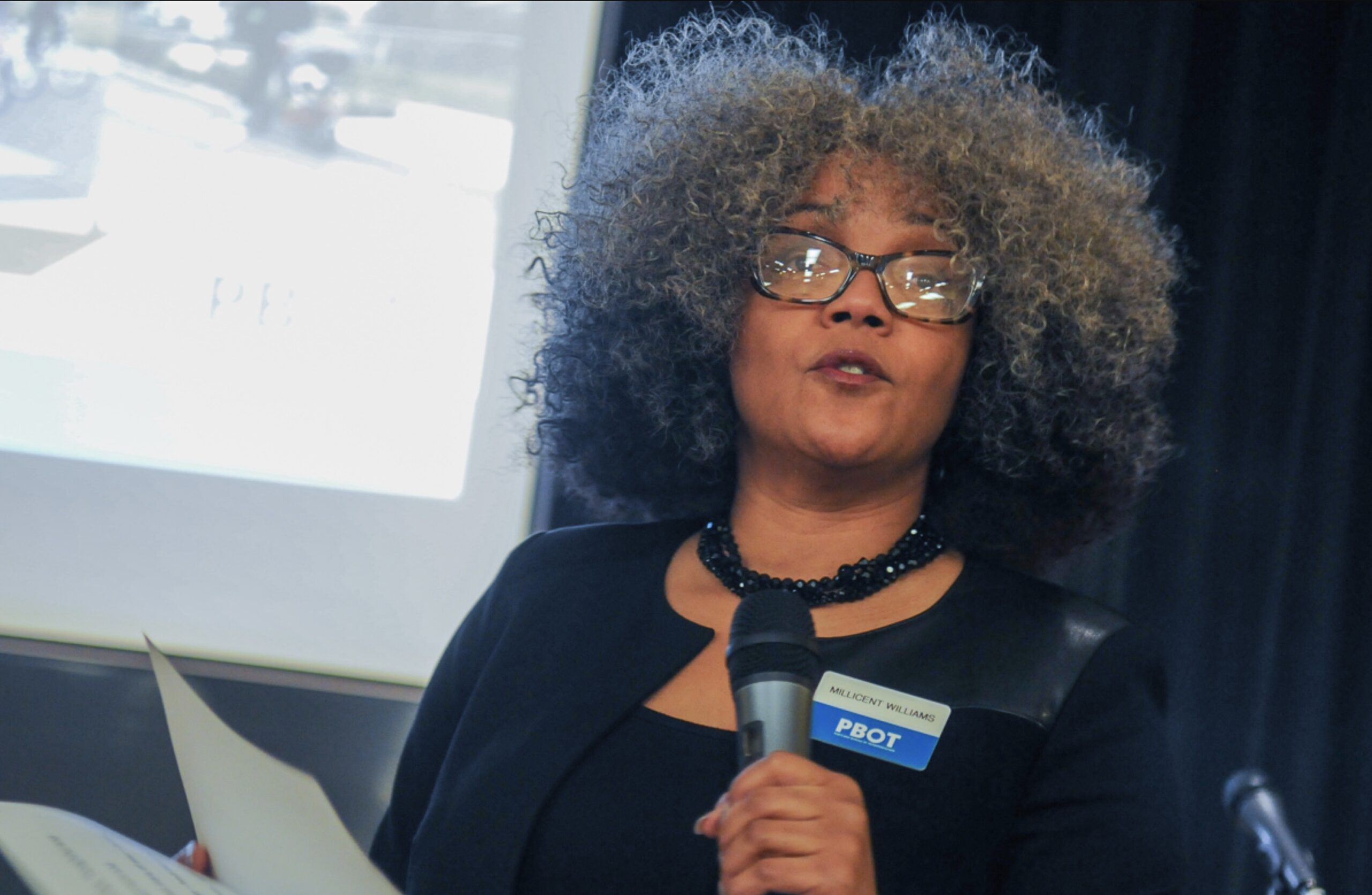
Millicent Williams at a PBOT meeting in 2019.Millicent Williams at a PBOT meeting on Southeast Division in 2017.(Photos: Jonathan Maus/BikePortland)
Millicent Williams is the new Director of the Portland Bureau of Transportation.
Williams is a former PBOT staffer who rose to the position of Deputy Director before leaving the city in May 2021. Before becoming deputy director, Williams was capital program division manager and most recently worked as regional director for Otak, a Portland-based engineering and planning firm. Williams also served as facilitator of the Equity Roundtable for the Interstate Bridge Replacement Program.
Williams fills the role left vacant since January when former director Chris Warner left to take a job with Oregon Governor Tina Kotek’s office.
Williams is the first Black woman to lead PBOT, and she arrives at a critical juncture as the agency is reeling with unprecedented budget challenges.
“I am energized by the opportunity to work with the dedicated staff at the Portland Bureau of Transportation in service to and in partnership with communities across the city,” Williams said in a statement. “At a time that when the bureau and city are facing tremendous challenges, I look forward to advancing PBOT’s work with compassion, viewing the work through an equity lens, considering the work in relation to our climate goals, and performing the work with excellence. Together, we will take a pragmatic, ‘Whole Community’ approach to problem-solving and embrace the promise of our future with optimism.”
PBOT Commissioner and mayoral candidate Mingus Mapps made the hire. He referred to Williams as someone who could make PBOT a “more pragmatic partner in building the future of Portland.” Mapps will put a tremendous amount of faith in Williams as his run for mayor puts more scrutiny on his leadership of PBOT and he looks to fulfill a promise to help the agency find its way out of a dark financial situation.
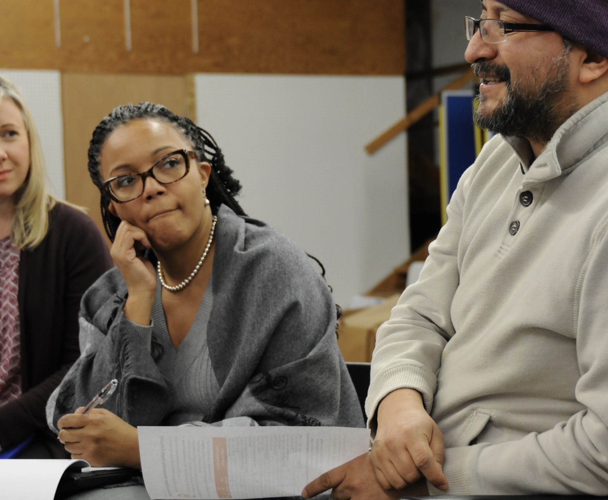
During her time at PBOT, Williams showed that she would not shy away from challenging conversations. In 2019, she led a tense PBOT meeting in a north Portland neighborhood that was debating whether or not to install a traffic diverter. It was a very notable meeting because PBOT was very up front that local residents would be allowed to decide if it should be built or not.
“We recognize that if we are going to be a bureau and city that demonstrates care, concern, and compassion for all, we have got to acknowledge our contributions to that pain and perform our work differently,” Williams shared with attendees, many of whom were Black. “Tonight’s conversation is for you. Tonight’s conversation is about you…This is your community and your project, let’s work together to get meaningful outcomes.”
Then in June 2020, just a month after the killing of George Floyd sparked nationwide protests over racism, Williams spoke out at a City Council meeting as part of a panel of guests to mark the Juneteenth holiday.
“I work in spaces where I know that my presence voice, access and expertise is unexpected, thought to be undeserved and often considered to be a threat,” she said. “I’ve worked across the full spectrum of public service and now I work in transportation, a discipline that has for many represented a sense of freedom, but for Black people has been a source of pain.”
Here’s more from her speech:
“I think about how a Black person was supposed to avert their eyes and step aside when they saw a white person on the sidewalk because silence meant safety. I think about redlining, road conditions, dissection and displacement in cities across America and a resultant forced silence which for some, if you weren’t subject to those things, meant safety.
Today I think about those examples and so many other things as we engage in solutions for communities across the city in managing the right-of-way and building infrastructure. As transportation professionals, it’s time for us to think differently about the industry, what it represents, and how we can influence the future.
At this juncture, either we will all be comfortable, or we’ll all be uncomfortable.”
In a statement from Commissioner Mapps’ office today, Williams said, “I look forward to advancing PBOT’s work with compassion, viewing the work through an equity lens, considering the work in relation to our climate goals, and performing the work with excellence. Together, we will take a pragmatic, ‘Whole Community’ approach to problem-solving and embrace the promise of our future with optimism.”
Williams’ first day on the job will be July 24th.
(Note: If you’ve worked with Williams and would like to share a comment about her for this story, please get in touch.)
Sellwood Cycle Repair is seeking a full-time bike mechanic. The ideal candidate has many years of professional bike industry experience. They value high quality repair work but understand that efficiency is essential. They value all types of bikes equitably. We require staff commitment to excellent service and communication, with all customers and co-workers alike. The ideal candidate will work well with everyone. Availability on Saturdays is a must. Pay rate is competitive and is based on experience. Benefits include medical, vision, and dental insurance. All staff have Sundays and Mondays off and earn, on average, 15-20 days of PTO per year. Weekly work schedules are flexible. Plenty of UTO is available.
How to Apply
Please contact shop@sellwoodcycle.com with an introduction and resume. Thanks!
The Oak Grove Festival is the perfect excuse to discover the Trolley Trail. (Photo: Jonathan Maus/BikePortland)
Welcome to the weekend! Here’s our weekly selection of rides and events worth your time. Please note, it’s Pedalpalooza time! That means there are tons of rides every day. See them all here. (Also note that rides usually leave 30 minutes after the posted meet-up time.)
This week’s guide is sponsored by Gorge Pass, your affordable transit ticket to carfree bike adventures in the Columbia River Gorge.
Friday, July 14th
Bike Play: Jurassic Bike — 6:30 pm at Abernethy Elementary School (SE) (*Same time/place through the weekend) The 14th annual Bike Play is dino-themed and sure to be another memorable performance. It’s a Pedalpalooza must-do! Costumes encouraged. More info here.
Saturday, July 15th
Mississippi Ave Street Fair — All day on N Mississippi Ave One of Portland’s best carfree street fairs is back and looks to be better than ever. Live music, tons of great shops and people. And getting their by bike is best! More info here.
Oak Grove Festival Ride — 10:30 at Milwaukie Bay Park (SE) The little town of Oak Grove is right on the Trolley Trail and so their annual festival is a perfect excuse to meet up for a bike ride. More info here.
Backdoor Ride — 10:45 pm at Shaku Bar (NE) If you like the urban wilderness, especially late at night when it’s most fun to explore, this is the ride for you. More info here.
Sunday, July 16th
Overlook N’hood Porch Fest — All day (N) Get on your bike and roll through the Overlook Neighborhood where you’ll find great live music at nine different houses. It’s the highest use of front yards and porches we can imagine. More info here.
Fiber Arts Ride — 10:30 am at Alberta Park (NE) “Calling all knitters, crocheters, spinners, weavers, sewers, and menders to flock together…Pack a portable project and get to know fellow fiber enthusiasts!” More info here.
Look mom! No Pedals! — 3:00 pm at Woodlawn Park (NE) A ride for little kiddos who prefer balance bikes! Route will be 100% in parks and play areas, so these tremendous tykes can enjoy their bikes in peace. More info here.
Riders in Recovery — 4:30 pm at Starbucks South Waterfront A strictly non-alcoholic ride for sober souls where bumpin’ tunes, turning pedals, and friendly vibes will provide the intoxication. More info here.
Intro to BikeCamping Clinic — 5:00 pm at Cyclepath Bike Shop (2436 NE Martin Luther King Jr. Blvd) Cyclepath will host two gear and riding experts at the shop for a night of insights, tips, and networking that will get you ready to roll on your next big adventure. More info here.
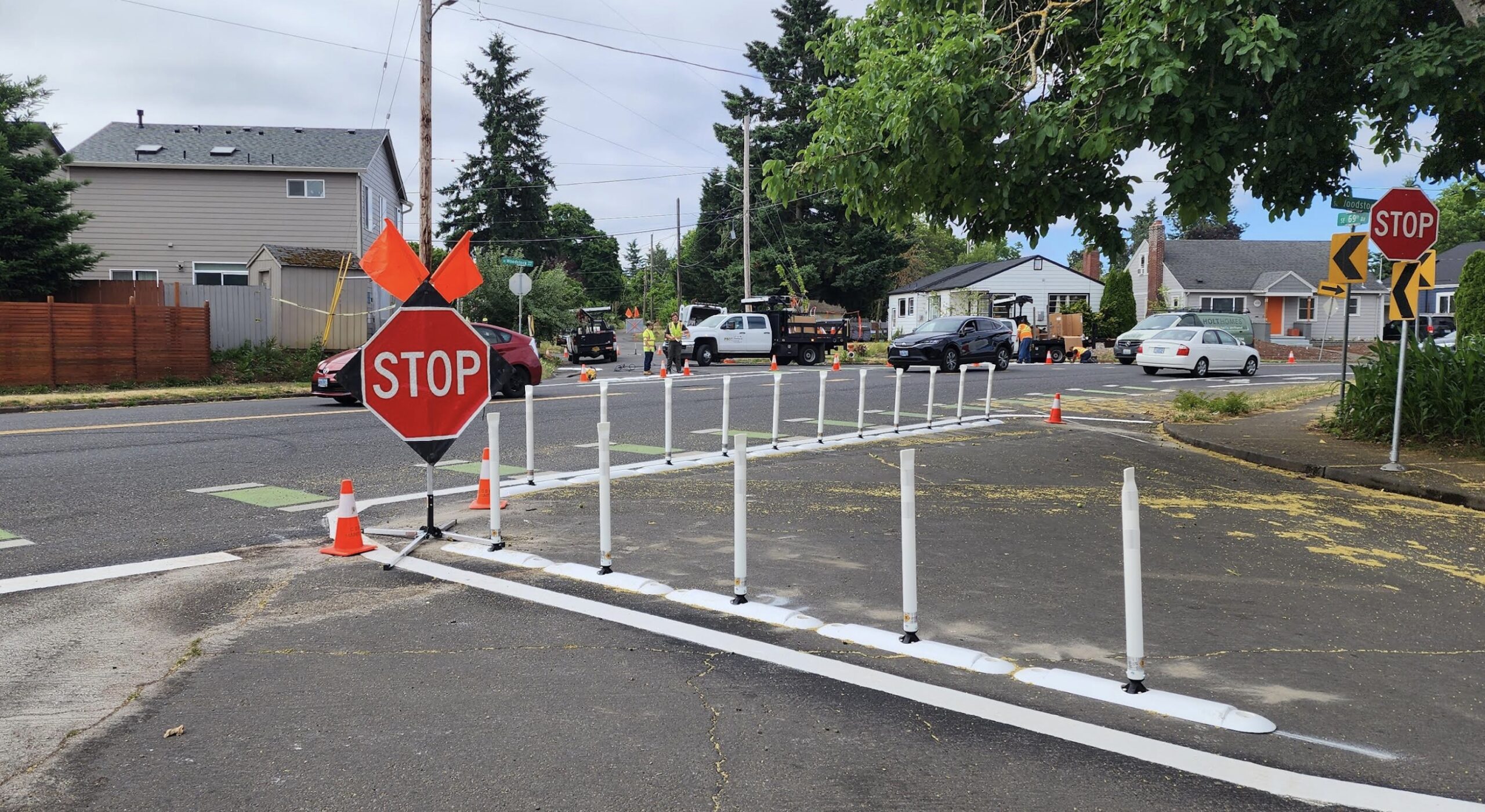
Looking south from 69th across SE Woodstock. (Photo: Matchu Williams)
The City of Portland has finally taken action to prevent bad drivers from crashing their cars into houses along an intersection in the Mt. Scott-Arleta neighborhood.
Back in January, I shared the story of an s-curve intersection on Southeast Woodstock and 69th. For years, residents told me, they worried that drivers would fail to negotiate the curve outside their homes. And many times, they did. There was a long, documented history of people going too fast and slamming into living rooms, front porches, sheds, and yards. According to the Portland Bureau of Transportation, in the five years between 2016 and 2021 there were seven reported crashes — five of which were a car driver slamming into a house or other object.
The combination of selfish and incompetent car drivers and the design of the wide intersection led to many sleepless nights and significant property damage.
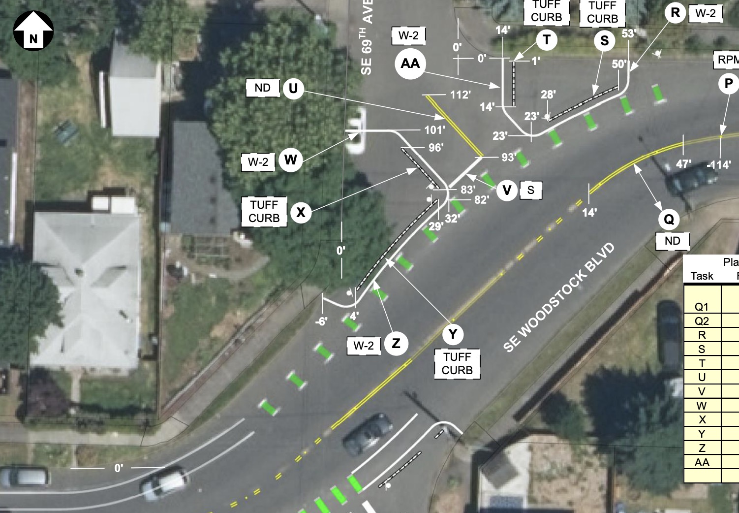
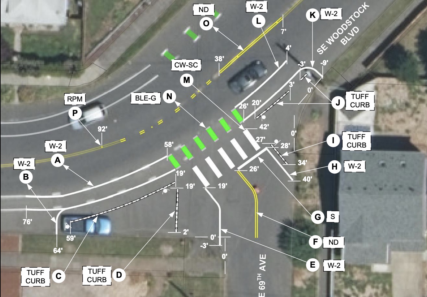
Then late last month, we learned that the Portland Bureau of Transportation implemented a project that squared off the “s” with new pavement striping, plastic curbs and wands.
(PBOT plan drawings of SE 69th and Woodstock)
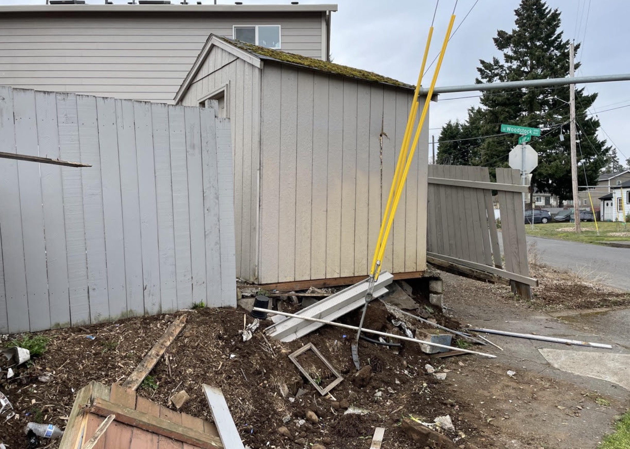
Damage to home from crash on March 18th. (Photo: Ben Mooney)
After my article back in January, nearby resident Ben Mooney reached out to say his home — at the southeast corner of the intersection, in the direct path of eastbound drivers on Woodstock — had been struck several times. His living room wall had sustained major damage and he was left fully responsible for getting it fixed. The crashes continued and it got so bad that he and his wife applied for a city permit to install steel bollards in the sidewalk median. Even though they were willing to pay for the bollards themselves, their application was denied.
They began to meet with PBOT traffic engineers and other neighbors to talk about a solution.
A few nights before one of the meetings in March, Mooney said it happened again (photo at right). “A car failed to make the turn going eastbound, jumped the curb, and crashed into the northwest corner of our property, destroying another section of our fence and damaging our shed,” Mooney wrote in an email to BikePortland. “Thankfully our house was unharmed, but we are still not even done repairing damage from the first event in December.” (In both events, the driver ran off and the car was presumed to be stolen.)
Mooney tried again for the permit and included the BikePortland article (at a PBOT staff person’s recommendation) in an appeal filed in early April of this year. Then they got some good news: They were told the city had received so many complaints that the permit wouldn’t be necessary and that a more long-term infrastructure fix was in the works.
When Mooney and other concerned neighbors learned from PBOT that the fix would be limited to “signs and paint,” he was a bit crestfallen. After one meeting to talk about the changes, Mooney emailed BikePortland to say, “This meeting really underscored how much emphasis is given to cars over the safety of homes, pedestrians, and cyclists, as most of the things we asked about were met with answers about how that would not work because of how it impacts traffic flow.”
After the project was installed in the past few weeks, I reached out to Mooney again to get his impressions.
“While my wife and I would have liked to see something a little more substantial to help reduce speeds going into the curves… now that we’ve seen the changes, we do think that they are an improvement to the intersection. We’re also grateful that they made this intersection a high priority,” he said.
“Cars do seem to be taking the curve at a more cautious pace, so in that regard I do think it is a success.”
Mooney says he’s still concerned about the long straightaway on Woodstock that allows drivers to gain considerable speed for 17 blocks between SE 52nd Avenue and his home. He’s inquired about traffic calming measures like speed bumps or stop signs, but so far PBOT has no plans to implement them.
Hopefully this paint, plastic, and signage is enough. And hopefully, PBOT can find more funding to come back and do something more substantial in the near future.
UPDATE, 7/14 at 4:00 pm: PBOT saw the concerns about the materials used in this project and shared: “The improvements we have installed so far are intended to be a temporary measure until a permanent reconfiguration of the intersection can be funded and built. The Lower SE Rising Area Plan could help advance the discussion of permanent improvements in this location and other parts of the area.”
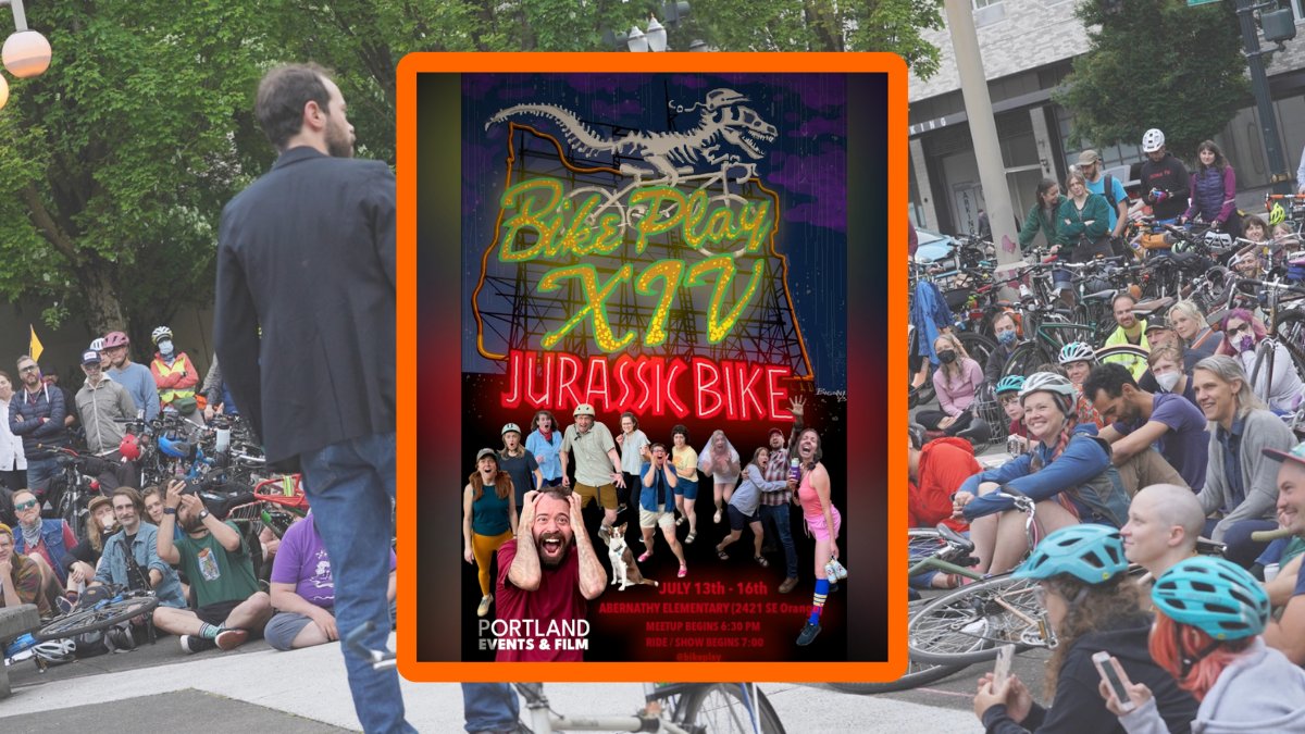
The 14th annual Bike Play kicks off tonight (Thursday, July 13th) and it’s going to be a scary good time.
What is Bike Play? It’s a theater production by professional actors who integrate bikes into the script and move between scenes in a massive group ride. Put another way, it’s a must-see event, easily one of the best things about Pedalpalooza, and an amazing example of Portland’s creative and accessible bike culture (it’s free!).
This year the title is Jurassic Bike. When I ran into the Bike Play crew at the Pedalpalooza Kickoff Ride on June 1st, cast member Emilie Landmann said we can expect all the fun, original stunts and songs Bike Play is known for, in addition to more puppetry and lots of scares.
“We can’t guarantee the safety of our riders,” Landmann said, jokingly. Then another cast member, Scott Weidlich, interjected, “The ride itself will be safe. It’s the dinosaurs that will be scary!”
Hold onto your bike seats, Bike Play is back and bigger than ever! Welcome to Jurassic Bike! We fused dino DNA with Bikes together to create the world’s first Bikeosaurs, what can possibly go wrong? Join the exclusive tour of Portland’s most dangerous biological preserve and witness the evolution of Bike kind. Bike finds a way! WARNING: Bike Play is not responsible for any sudden dinosaur attacks*.
Dino-related costumes are encouraged!
Bike Play begins at 7:00 tonight at the Abernethy Elementary School (2421 SE Orange Ave) playground. Meeting up starts at 6:30 and I highly recommend getting there early if you want a good place to sit. For more updates and info, follow Bike Play on Instagram.
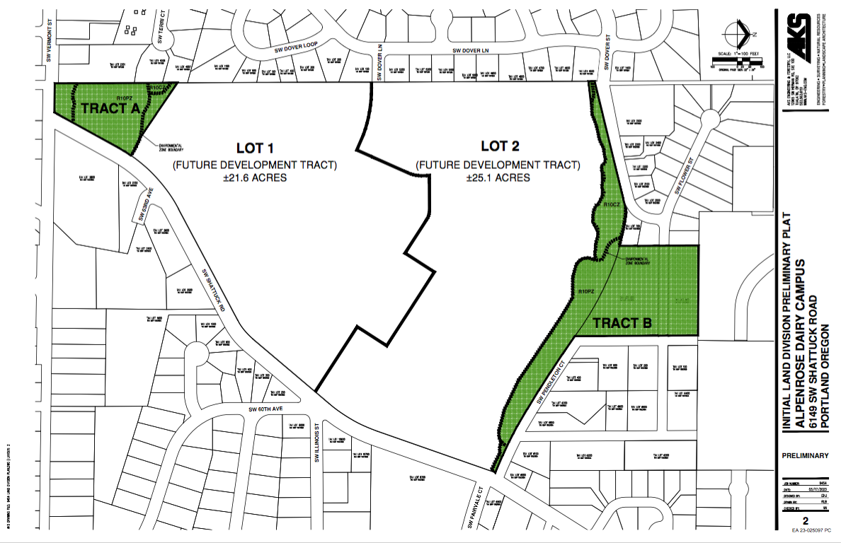
Alpenrose Dairy, looking south along SW Shattuck Rd. (Photos Lisa Caballero/BikePortland)
Alpenrose site is the green triangle.
Last week, the Bureau of Development Services (BDS) posted the summary notes of the Early Assistance meeting between the developers of the Alpenrose site and the city permitting bureaus.
I was probably a happier person before I knew what all that meant.
But I’m trying to understand how it has come to pass that, over half a century after the southwest was annexed to the City of Portland, the quadrant persists in having such bad sidewalk coverage and incomplete bike facilities despite steady growth in population and new buildings.
Understanding the nitty-gritty of “why” ends up being a wonkfest at the intersection of transportation and land use policy. But that wonkiness goes down a little easier if you can watch decisions roll out in real time.
The high-profile Alpenrose housing project which has begun moving through Portland’s development review system provides an opportunity to do just that. And the notes from the Early Assistance meeting are the public’s first peek at the decisions the Bureau of Environmental Services (BES) and the Portland Bureau of Transportation (PBOT) will make about sidewalks and bike lanes. These early decisions determine whether sidewalks and bike lanes will be built at all.
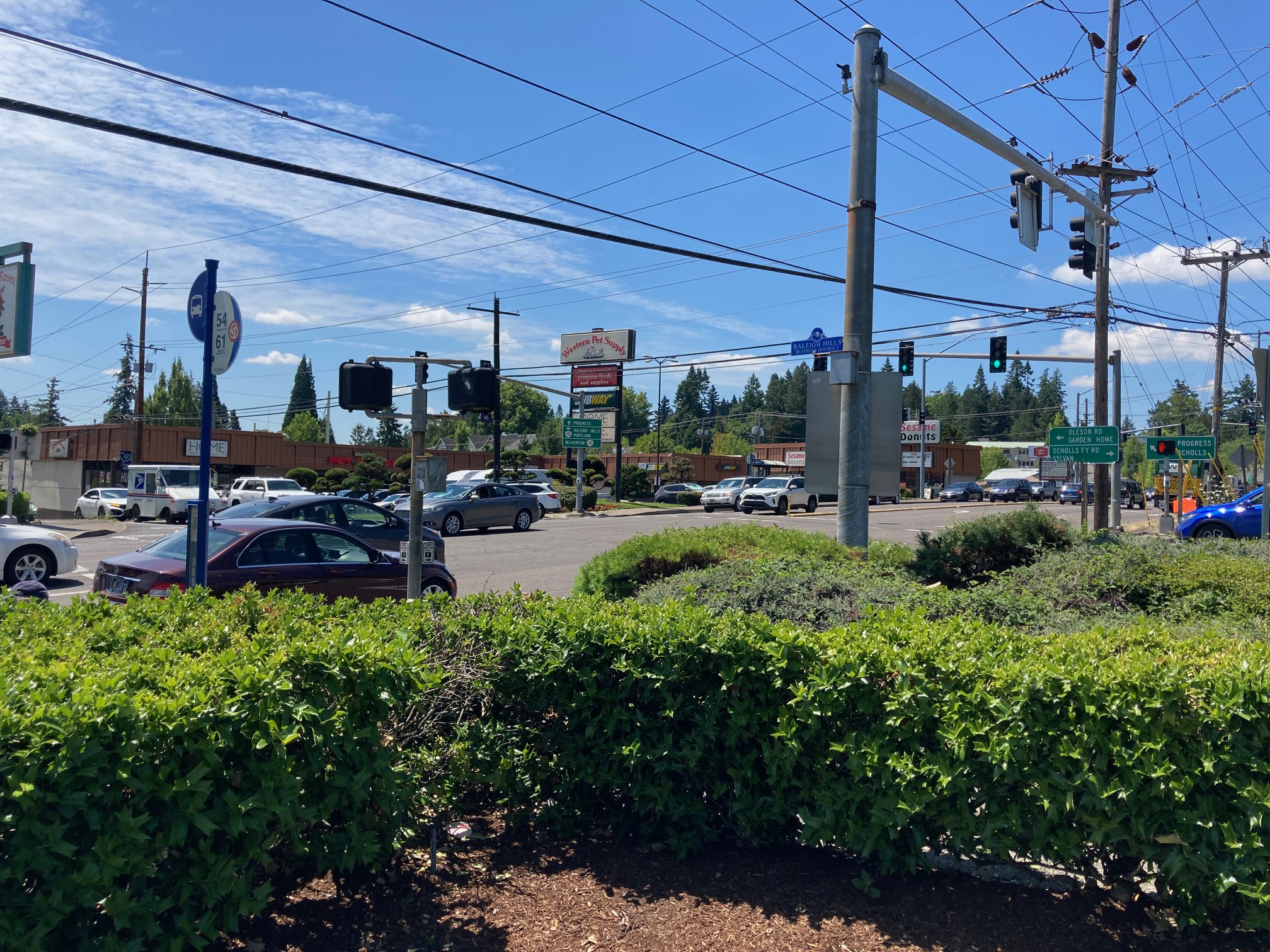
The infamous “crash corner” intersection of SW Oleson Rd and Beaverton-Hillsdale Highway sits about a quarter mile north of Alpenrose.
The development
The developers have proposed dividing the 51-acre property into approximately 307 lots of attached and detached houses. Depending on the ratio of attached to detached houses, some of the detached houses could still come with a generous lot size, say a quarter of an acre.
A 51-acre development proposal is unusually large for Portland, and the Alpenrose project will be the first of its kind coming under review since “Missing Middle Housing” legislation was adopted at both the local and state levels.
You might recall that the recent middle housing zoning changes allow homeowners to build up to four units on most residential lots. In Portland, this new zoning policy was called the Residential Infill Project (RIP), and the City Council adopted it in 2020. The council was not unanimous in its decision to loosen zoning regulations, but proponents argued it was necessary for dealing with housing scarcity, and also as a response to racist and exclusionary zoning policies.
The catch is that the future owners of each of the 307 new Alpenrose lots will also be allowed to exercise their “missing middle” zoning rights. That means they could add more dwellings to each property. Thus the 307 units could expand into a “reasonable worst-case scenario” that would overwhelm area infrastructure, particularly transportation. As BDS noted,
ORS does not allow us to impose conditions of approval that would disallow middle housing development types; at this point staff needs to understand more about the challenges to infrastructure and specifically transportation limitations before being able to weigh in on whether the proposal is approvable or not as proposed, or what conditions of approval would be enforceable or desirable to address the issues.
It continued, “the importance of addressing the infrastructure challenges with this site cannot be overstated.”
PBOT also weighed in,
Adequacy of services findings and compliance with the comprehensive plan policies needs to be analyzed based on the anticipated demand from the full buildout potential of the requested zoning.
I don’t know if RIP proponents had vast tracks of new development in mind when they crafted the zoning changes, but the bureaus appear to be wrestling with a “dog catches car” scenario of too many houses for an inadequate transportation system.
Proposed zoning
Active transportation and the two-bureau shuffle
The specific purpose of the Alpenrose Early Assistance meeting (also known as a Pre-Application Conference) was to discuss the Comprehensive Plan Map and Zoning Map Amendments, as well as a Land Division Review, which the extensive development plan would require.
Early Assistance meetings are organized as an exchange of information which lets various bureaus comment on requirements and key issues in advance of the developer submitting an application.
And this is where the two-bureau shuffle begins.
From a transportation point of view, the most relevant Early Assistance comments come from BES and PBOT. What is important to understand is that BES is in the driver’s seat, PBOT cannot do much unless BES agrees to build new stormwater facilities.
PBOT starts out strong, “The applicant should anticipate sidewalk and bicycle facility construction along SW Shattuck Rd. and SW Vermont St. for the entire length of the parent parcel at the time of the future development.”
Quickly back tracks, “some form of pedestrian and bicycle improvement is needed in the public right-of- way, but it is anticipated that full standard improvements may not be feasible.”
And concludes that “If improvements are not fully waived, then a Public Works Permit is needed to inform approval of non-standard improvements through the Public Works Alternative Review process.”
PBOT went from requirement to waiver in three short pages.
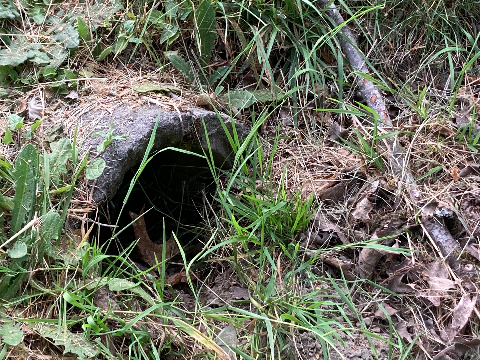
Pipe in a ditch on the side of SW Stattuck Road. The street lacks a formal stormwater system.
The Public Works Alternative Review (PWAR)
The quote above mentions the Public Works Alternative Review. The PWAR is a process whereby an applicant can request allowance to build an alternative design to standard improvements in the public right-of-way, if for some reason the city decides that standard frontage improvements like sidewalks and bike lanes cannot be built.
About the Alpenrose project specifically, PBOT writes that,
It is anticipated the applicant will wish to propose an alternative to the standard given the terrain and natural resources present for some portions of the existing rights-of-way.
PBOT doesn’t mention lack of stormwater conveyance as a reason that a sidewalk can’t be built, but Shattuck, like most southwest Portland streets, drains its stormwater into area streams. A sidewalk would require a bioswale or a stormwater basin to treat sidewalk run-off, like the ones the city built off of Capitol Highway.
The PWAR committee is composed of managers from PBOT, BES, Water, and Urban Forestry. Their decision process is not public. It is a black box which tends to output tersely worded requirements such as, “The applicant shall provide a minimum 6-ft wide paved shoulder widening.” Unfortunately, PWAR is where sidewalks and bike lanes go to die.
Throughout the document, PBOT and BES defer to PWAR decisions as if they weren’t involved with making them. Here’s BES,
Frontage improvements as described by PBOT may trigger stormwater management requirements. If frontage improvements must be built with this land division (depending on the results of any requested Alternative Review Committee decisions) and the improvement trigger stormwater management requirements, BES will require approved PWP Concept Development …
If BES does not want to build public stormwater facilities, the PWAR solution usually has pedestrians walking at grade with cars, either on the road or to the side of it along a goat path.
What happens next
The next step in the development review process will be the actual Public Works Alternative Review decisions themselves. Those will be the first indication of the city’s support for safe spaces to walk and bike. Those decisions bake-in the frontage requirements early in the process, and the whole subdivision will be designed around them.
PWAR decisions are available with a public records request.
Lawyering up
One of the most curious paragraphs in the Early Assistance Summary comes from PBOT and advises the applicant about defending against legal challenges:
If the proposed land division is challenged or opposed by neighbors or the area’s neighborhood association, PBOT will not have any supporting documentation in the record to refer to other than the applicant’s narrative. This is raised because of similar experiences in the past when other partition proposals were challenged, opposed to or appealed. In those cases, applications were required to be placed on hold for information to be collected, prepared and submitted, or applications were fundamentally denied due to the lack of adequate and credible evidence in the record. PBOT staff may be able to determine that the project will not result in detrimental impacts to the surrounding transportation system or immediate neighborhood, but the applicant is advised that if the decision on this project is appealed, the higher decision-making bodies have not (solely) relied upon PBOT’s assessment and/or recommendation. The applicant is referred to Zoning Code Section 33.800.060 which states that “the burden of proof is on the applicant to show that the approval criteria are met; the burden is not on the City or other parties to show that the criteria have not been met.”
And the truth is that that the entire process can be litigious. What PBOT doesn’t mention, possibly because this document is in the form of a memo between city bureaus and the developer, is that another worry the city has is that it will be sued by the developer.
This can happen if the developer feels that the city is trying to exact too much from them in terms of public works, like providing expensive stormwater facilities for sidewalks, for example. The body of jurisprudence regarding these types of suits is referred to as Nollan/Dolan.
Keep in mind that “Dolan” is Dolan v. City of Tigard, a case decided in 1994 by the U.S. Supreme Court which is considered a landmark regarding zoning and property rights. The Dolans did not want to dedicate land for the adjacent Fanno Creek Trail.
That land use decision occupies significant real estate in Portland’s mind.
Wrapping it up
I’m eager to see the PWAR decisions. If they follow the usual “southwest rules,” Shattuck will get a treatment similar to Gibbs St. Or maybe the PWAR will select a treatment out of the alternatives in the Pedestrian Design Guide.
On the other hand, allowing over 300 new housing units to be built without a sidewalk on the northern Lot 1 and Lot 2 portions of the property is outrageous, and might be challenged.
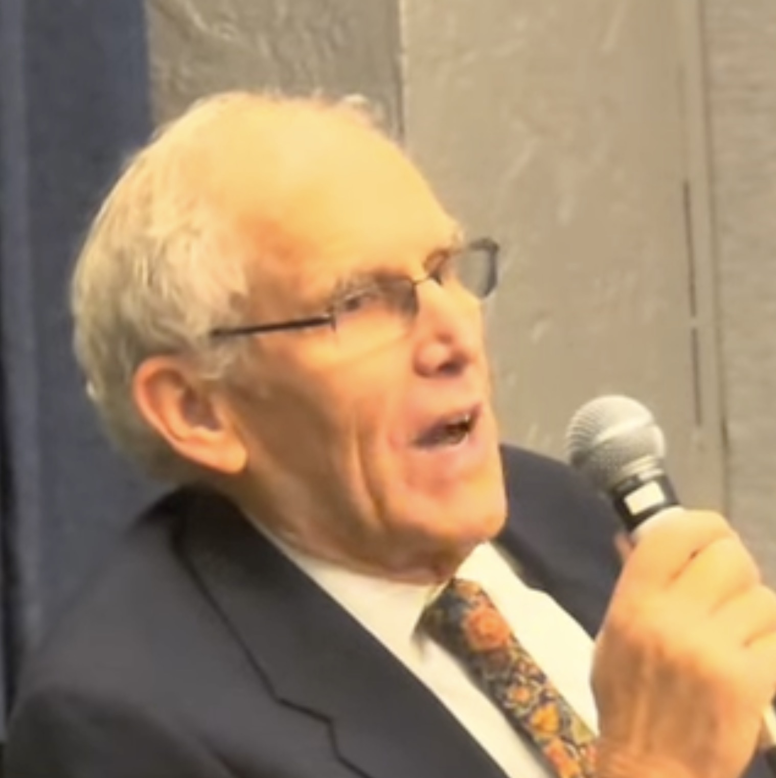
The top official in charge of the Interstate Bridge Replacement Program got into a heated back-and-forth with critics at a neighborhood meeting back in December (view it in the video above). IBR Program Administrator Greg Johnson questioned the man’s credentials and called critics’ claims “nonsense” before a moderator stepped in to cool things down.
The exchange was shared on Twitter yesterday by Bob Ortblad, a retired engineer and active critic of the project. Ortblad has pushed his idea for an immersed tube tunnel across the river (instead of a bridge) for years and it appears that his activism around this issue has gotten under the skin of Johnson.
As we shared in February 2022, Ortblad sees several advantages to a tunnel across the Columbia River. He believes it would be cheaper (the estimated cost of the IBR currently stands at $6 billion), have a smaller footprint, wouldn’t lead to a high bridge with a significant incline/decline, and so on. His dogged advocacy for the tunnel and a general distrust of the IBR team, has helped win support of many people who live on Hayden Island.
Bob Ortblad.Greg Johnson
The Hayden Island Neighborhood Network supports a “No Build” option for the project and has pushed the IBR to study more options — including a tunnel. On March 5th, Hayden Island Neighborhood Network Board Chair Martin Slapikas wrote a 14-page letter to the Oregon Government Ethics Commission that blamed Johnson and the IBR of a conflict of interest.
Suffice it to say there is no love lost between IBR staff and some residents of Hayden Island.
The exchange at the December meeting came after Ortblad shared a 20-minute presentation about the tunnel. In a Q & A session that followed, Ortblad shared a very sharp criticism of a tunnel option study published by the IBR that he called, “inaccurate.” “[The tunnel study] just doesn’t hold water,” Ortblad told the audience. “It should be retracted.”
Then Johnson was asked a question about whether or not the IBR has a 3-D model of the proposed bridge design (a key thing fueling distrust has been the lack of detailed visuals of the project). Johnson took the mic and said the IBR has a 3-D tactile model of the bridge they created for people with visual impairments. The model is only available for viewing at the IBR offices.
“We don’t have a final design yet,” Johnson continued.
“So that’s a no?!” someone (who appeared to be noted provocateur and activist Joe Rowe) then yelled from the audience.
“We have a 3-D model in our office, sir, where you can come over you can see it.”
“So 10 minutes ago I asked Ray [Mabey, Assistant Program Administrator for the IBR] and he said ‘no’ so I gave him the finger because I know you all lie. So you do have one! What’s the truth Ray?!” Rowe continued to shout.
A moderator then stepped in to try and cool things down.
Then Johnson (with the mic in hand) turned toward Ortblad and said:
“Bob has accused folks, who are licensed engineers, of malpractice. Bob, where’s your license? Or are you just a citizen who is interested? You are talking about folks who are licensed.”
“I had a license for 40 years,”
“But where is it now?” Johnson replied.
Then Rowe yelled, “You work for us! You should answer questions! Take the heat, Greg!”
“Bring the heat!” Johnson replied.
Then when the moderator stepped back in, Johnson said, “I will not listen to nonsense.”
At that point, the moderator took the mic from Johnson and tried again to calm everyone down.
Then a few seconds later, Johnson began to speak again and said, “We’re not afraid to be challenged, but I will not stand for folks’ reputation being besmirched to say we are putting out inaccurate information.”
The exchange shows how pressure around these flailing megaprojects impacts the people who work on them. Two weeks ago we shared how another top staffer in charge of another I-5 expansion project broke down during a meeting after having to tell committee members the project he promised would bring hundreds of high-paying jobs would have to be paused due to a lack of funding.
Zef Wagner, who responded to the video on Twitter, said that despite these pressures, Johnson’s behavior as a public servant was, “truly unprofessional and unacceptable.” “As someone who has been in plenty of public meetings in a similar role, representing a government agency, I certainly hope I never disrespect a member of the public like this.”
The exchange also illustrates just one of the flashpoints around the IBR, a project that just barely received support from the Oregon Legislature this past session. One the final day of the session, lawmakers agreed to commit $1 billion in general obligation bonds ($250 million a year for four years) to the project. That commitment was crucial for competing for federal grants and it matches what Washington has already committed.
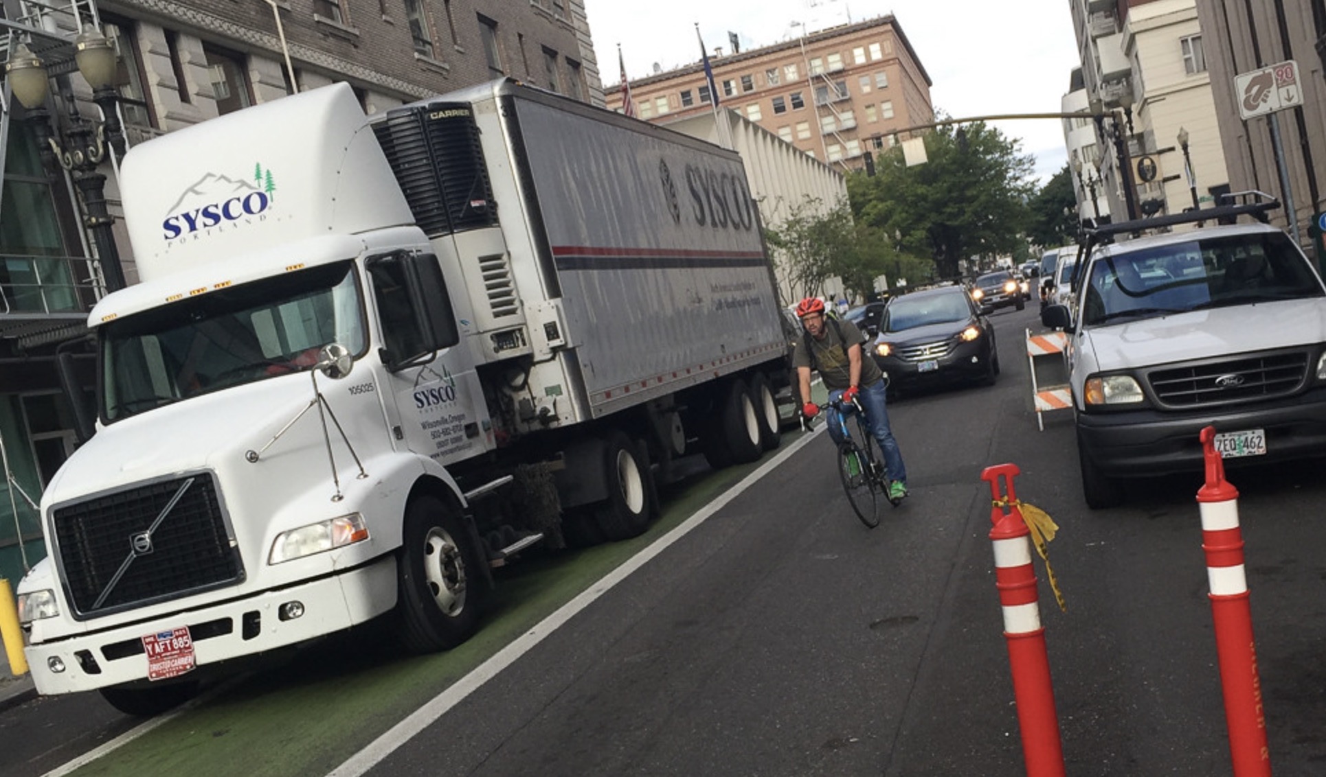
The plan could help reduce the number of large, bike lane-blocking trucks downtown. (Photo: Jonathan Maus/BikePortland)
The Portland City Council is poised to pass a new freight master plan at their meeting Wednesday — a step that comes more than three years after the Portland Bureau of Transportation launched the effort. The new plan, 2040 Freight, will update the existing plan that council adopted in 2006.
We watch freight advocacy and planning closely because of the very tragic record of cycling deaths that have involved trucks and their drivers — as we saw most recently last October when Sarah Pliner was killed in a collision with a semi-truck while trying to cross Southeast Powell at 26th. Portland’s freight advocates have also influenced many bike infrastructure projects over the years. It was taxes paid by truck companies that helped get the separated bike path on North Greeley Avenue built, and it was the Portland Freight Committee (PFC) that opposed the addition of bike lanes to North Lombard (thankfully they got put in anyways).
Some members of the Portland Freight Committee at their meeting last week (middle and upper left are PBOT staff).
With the 2040 Freight Plan, the Portland Bureau of Transportation will have an updated guide to manage the freight system and a good opportunity to refresh its freight committee. Unlike PBOT’s bicycle and pedestrian advisory committees, members of the PFC have been able to far exceed term limits. In 2017, in an effort to rebalance and diversify all of its advisory committees, the City of Portland set new term limit rules for advisory committees. This led to several senior members of the Bicycle Advisory Committee having to leave against their will. But when some veteran PFC members pushed back on the new rule, former PBOT Commissioner Chloe Eudaly gave them a special dispensation: They could remain on the committee in order to develop the 2040 Freight plan. Now that it’s completed, it will be interesting to see whether current PBOT Commissioner Mingus Mapps follows through with city policy and makes the PFC recruit over a dozen new members.
It is patently unfair to require the bicycle and pedestrian committees to welcome new members while allowing the freight committee to retain veterans. This has given freight interests a major advantage when it comes to influencing PBOT policies and projects.
Thanks for indulging that little digression… let’s get back to the 2040 Freight plan.
Like other modal plans, PBOT is required by law to have one on the books. The plan does several things: it lays out a framework for making policy and project design decisions, it helps PBOT compete for grants (being able to say, “Xyz project is in our freight plan” helps a project score better), it includes a prioritized list of infrastructure projects, sets freight-related street classifications, and helps give city planners and advocates a deeper context for how the movement of freight fits into the transportation system.
(Source: PBOT 2040 Freight)
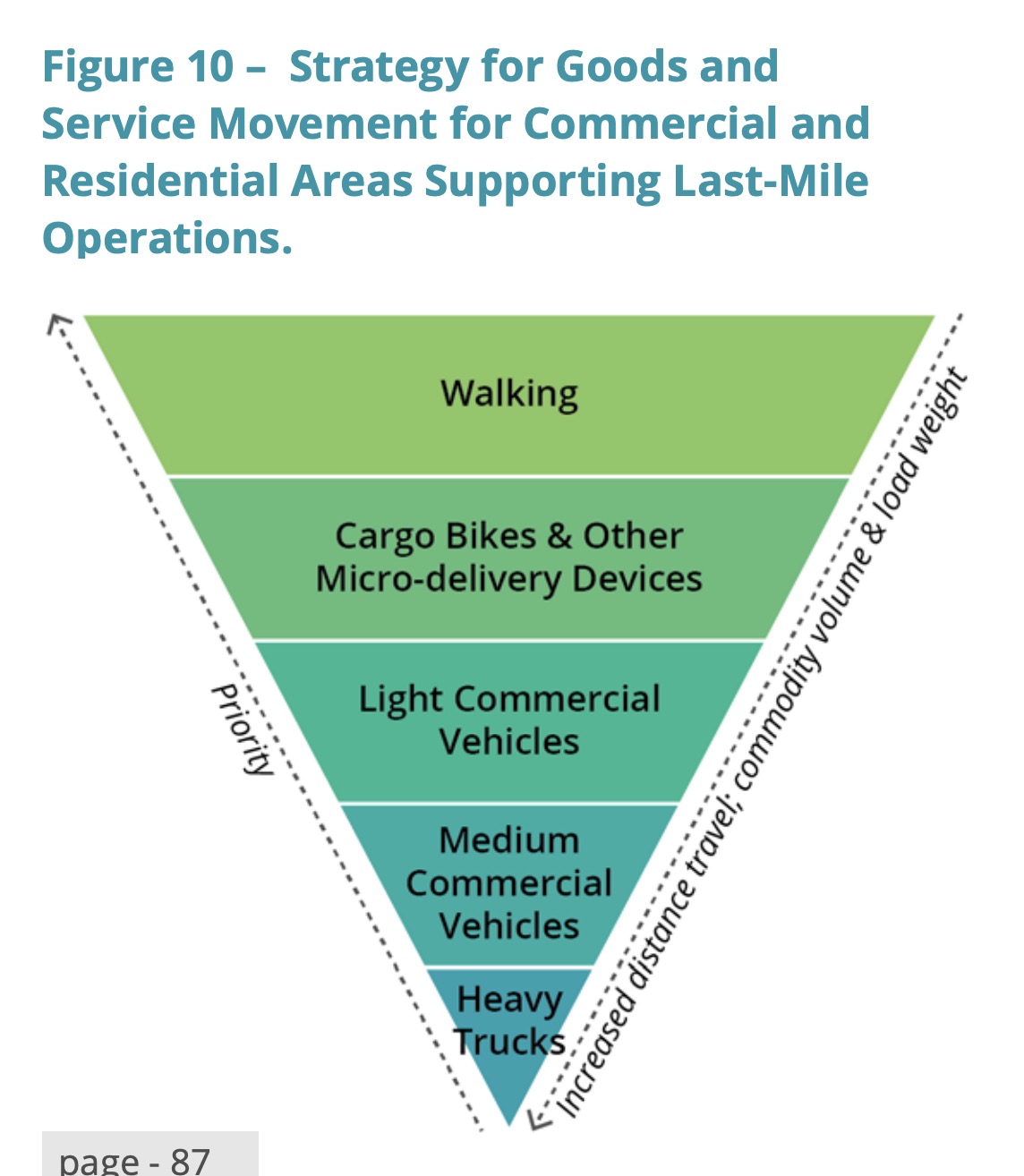
Part of the new freight plan looks to correct past mistakes in how we understand its role. Instead of seeing “freight” as large trucks and a mode of travel alongside “bicycle,” “pedestrian,” and “single occupancy motor vehicle,” PBOT says that framing “fundamentally mischaracterizes it as a mode.” Instead, PBOT sees freight as a system where many different modes work together.
For instance, if the distance is short and the package is light, PBOT says the best freight vehicle would be feet (see graphic at right). For slightly longer trips and heavier packages, an electric bicycle might be the recommended vehicle.
A key takeaway from 2040 Freight is that PBOT wants to get smarter about how the land use and urban design context dictates freight movement.
Right now, the balance is off. Currently the plan states that about 75% of freight movement in the Portland metro area relies on trucks. That means the negative impacts of those trucks — diesel emissions, noise, traffic safety concerns, etc. — has significant impact on our roads and residents. And Multnomah County research shows neighborhoods with a majority of Black, Indigenous and other people of color are exposed to those externalities at two-to-three times the rate of the average Portland-area resident.
A page from the plan.
And with heavy trucks accounting for about 15% of the total diesel emissions in Portland, you can see why PBOT wants to make freight movement cleaner. Their downtown zero emissions delivery zone is one step they’ve already taken. A different mix of delivery vehicle types will also help.
Smaller and cleaner vehicles will not just help with air quality, they will also free up valuable space at the curb and other congested areas as well as reduce injuries and deaths from traffic collisions.
In the safety section of the plan, PBOT says most freight truck collisions happen at intersections, therefore, “Implementing safety countermeasures for vulnerable users, such as separated facilities for bicyclists, clear signage, or providing for alternate parallel routes will improve safety…”
The plan should help spur more physically separated cycling infrastructure. In a section that defines the “Industrial Roads” street classification, PBOT states, “Pedestrian and bicycle crossings should be grade-separated or signalized, and pedestrian and bicycle facilities should be separated from motor vehicle traffic.”
One of the most important parts of the plan is the list of projects. There are 55 projects in the plan worth over $812 million — 14 of which ($265 million worth) are identified as “high priority.” (Note: The plan does not allocate any money to these projects. It is just a list of estimates for planning purposes)
Most of the high priority bridge and highway projects in the plan are located along Columbia Blvd. Two projects totaling $14.5 million along the popular NE 33rd Avenue bike route would include cycling safety updates at Lombard and Marine Drive.
Also notable is that both 33rd Ave (between Columbia and Marine Drive) and Marine Drive (between 33rd and I-205) will be changed to a higher freight street classification in the Transportation System Plan (TSP). These classifications are very important because they dictate what type of cross-sections and design treatments are feasible.
This section of NE 33rd will become a “Major Truck Street” in order to, “recognize the importance of this street for freight movement flow in/out of key origins/destinations within the Freight District.” And Marine Dr will go from Local Service Truck Street to Freight District Street.
These changes reflect PBOT’s desire to “unlock” adjacent industrial areas and make them more freight-friendly. Will it come at the expense of safe cycling infrastructure? That remains to be seen, but it certainly gives freight advocates a leg up in future debates.
Several other projects and policies in the plan have significant cycling impacts. We’ll be covering them as they develop in the months and years to come.
City Council will take up the resolution to adopt the plan at their meeting on Wednesday July 12th at 2:00 pm.
Some of you have literary aspirations, I can tell. Maybe an unpublished novel buried in the back of a desk drawer?
What gives the ambition away is the purple prose that sneaks into BikePortland comments: “waste bin of bike dreams,” “slaughtered on our blood-soaked streets,” “I’ve been looking for years and I know it’s out there.”
Whew.
Is this Raymond Chandler’s Los Angeles? No, it’s not. But maybe Portland needs its own poet of despair.
TrikeGuy might fit the bill. He wrote a colorful comment last week about a commute that didn’t go according to plan, and he manage to tie it into our post about McLoughlin Blvd, barely. Here are his first two paragraphs:
Wednesday I really wanted to take the 4:12am red line into Goose Hollow then ride the relatively flat 15 miles to Clackamas – couldn’t do that because they canceled it.
Of course, you don’t know they canceled until 4:12 comes and goes and you walk down to the only readerboard at the west end of the center platform (past a group of 5 guys smoking meth) and see the next train scheduled at 4:42.
I tried my hand at his prose and with some small edits arrived at this:
It was early. Too early. Even the 4:12 was sleeping it off ‘till 4:42. But I had somewhere to be, and I wasn’t going to let a late train or five meth-heads get in my way.
Clackamas will do that to you.
Go ahead, embrace your inner noir! Here’s the rest of TrikeGuy’s raw material:
Naturally I hopped on the trike, rode north and up out of Beaverton to Wilshire, up and over 217, up along 26, up through the Zoo to Fairview. A fast drop, then deal with the really awful roadway on lower Fairview and Park to get down to Goose Hollow (don’t even think about going up over Salmon past Lincoln – potholes big enough to lose my trike in).
Nothing like adding 8miles and 900ft of climbing to the morning commute on a day when I didn’t plan to.
Still better than the poor guy who only goes into the office 2 times a week who had to pay $$$ for an Uber to get to work in time (I chatted with him Thu morning).
Then, on the way home, I decided to ride the shortest distance to a MAX due to the smoke in the air (sucking that in is not good for you).
Waited 15minutes at CTC for a Green Line to show up just to hear that it was going to be stopping at Main Street – there was a MAX broken down between there and Gateway. Yep, great mainenance TriMet
Naturally I hopped off there and rode the worst section of 205 (crossing several busy streets where cyclists are very much discouraged) and through 2 small linear camps with debris all over the path.
This ignores the lack of safety officers on TriMet enforcing such basic courtesies as not playing loud music, not blocking the aisles with bikes/e-bikes and (of course) not smoking meth on the platforms.
Thank you TrikeGuy! (My apologies to you and Mr. Chandler.) You can read TrikeGuy’s comment under the original post. And keep your eye out, BikePortland commenters sometimes transcend the genre.
Welcome to the week. Here are the most notable stories our writers and readers have come across in the past seven days…
This week’s roundup is sponsored by the City of Portland District Commission, who encourages you to learn more about their Draft District Plan maps and share your feedback today!
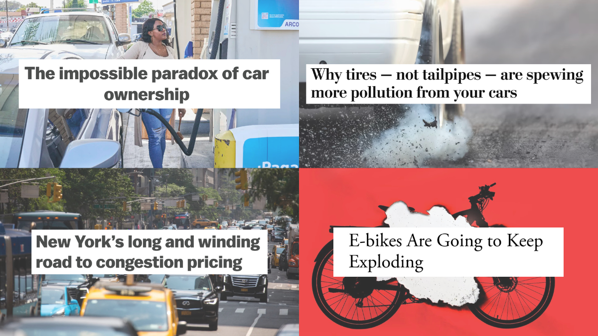
Why we need cars: This is a really good look at why, for some low-income earners, owning a car just might be worth the negative externalities. (Vox)
Woom kids bike recall: Handlebars could detach from some models of woom Bikes sold in the USA between 2018 and 2021. A recall applies to about 84,000 bikes. (CPSC)
Safer vehicles: There are several proposals from the federal government that would make U.S. cars and trucks safer, but they need to hear from you before the auto industry waters them down even more. (Streetsblog USA)
Congestion pricing timeline: We can be excited that New York City is finally moving forward relatively fast with congestion pricing, and we can also lament that it took so damn long. (Vox)
Exploding e-bikes: I feel like after the recent fire in New York City it’s only a matter of time before the federal government does something major to fight this “exploding e-transportation problem.” (The Atlantic)
Degrowth is an answer: I’m convinced that we need to stop default growth assumptions and start to seriously scale back the size and speed of our lives if we want to save the planet. (New Yorker)
Tire pollution: Particulate matter from rubber tires is a very real source of pollution — as much if not more than from tailpipe emissions — and we should promote tires from less toxic materials and hasten government regulation. (Washington Post)
Car violence in UK: Most of the text in this story is (rightfully) about the victims, but we need to talk more about the causes and consequences of dangerous driving if we want to see this type of common crash curtailed. (Guardian)
Extend and pretend: Noted freeway fighting economist Joe Cortright says, “The Rose Quarter will be a zombie project, utterly un-funded, but technically not dead, because ODOT (and its enablers) pump millions into keeping it on life support.” (City Observatory)
Bike bubble burst: A strong market for used bikes is just one reason why one bicycle industry expert thinks sales of new bikes has declined. (Bicycle Retailer)
Cone protest: Anti-car activists found a brilliant way to disable driverless cars in San Francisco. (Guardian)
Not hard to see why so many walkers and bikers are injured and killed on McLoughlin Blvd. (Photos: ODOT)
ODOT graphic
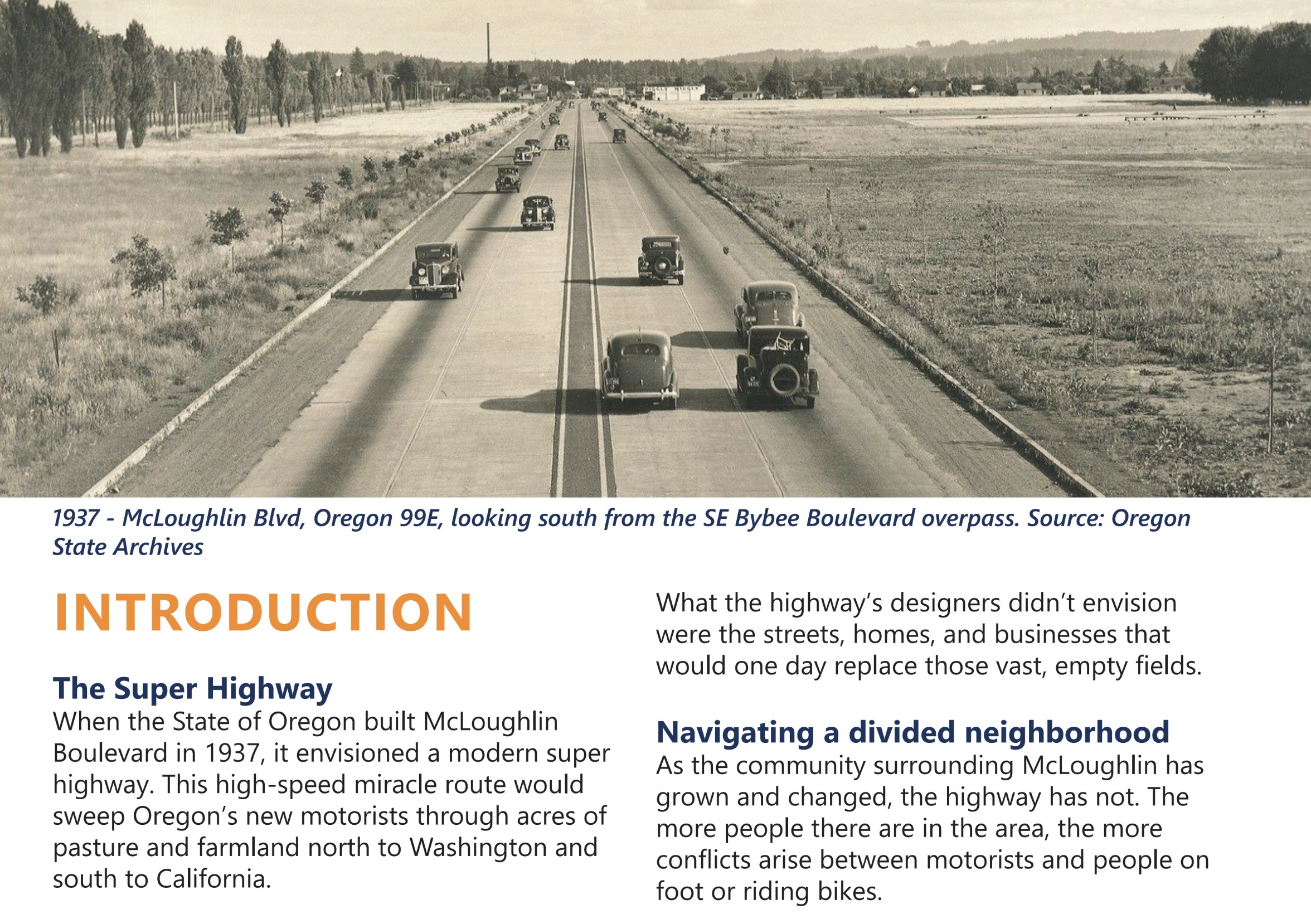
“The builders of the McLoughlin ‘super highway’ envisioned a kind of freedom no one in Oregon had experienced before. Today, we envision another kind of freedom—the freedom to navigate your neighborhood on foot, get to work on the train or bus, or ride your bike to school without worrying about getting where you are going safely.”
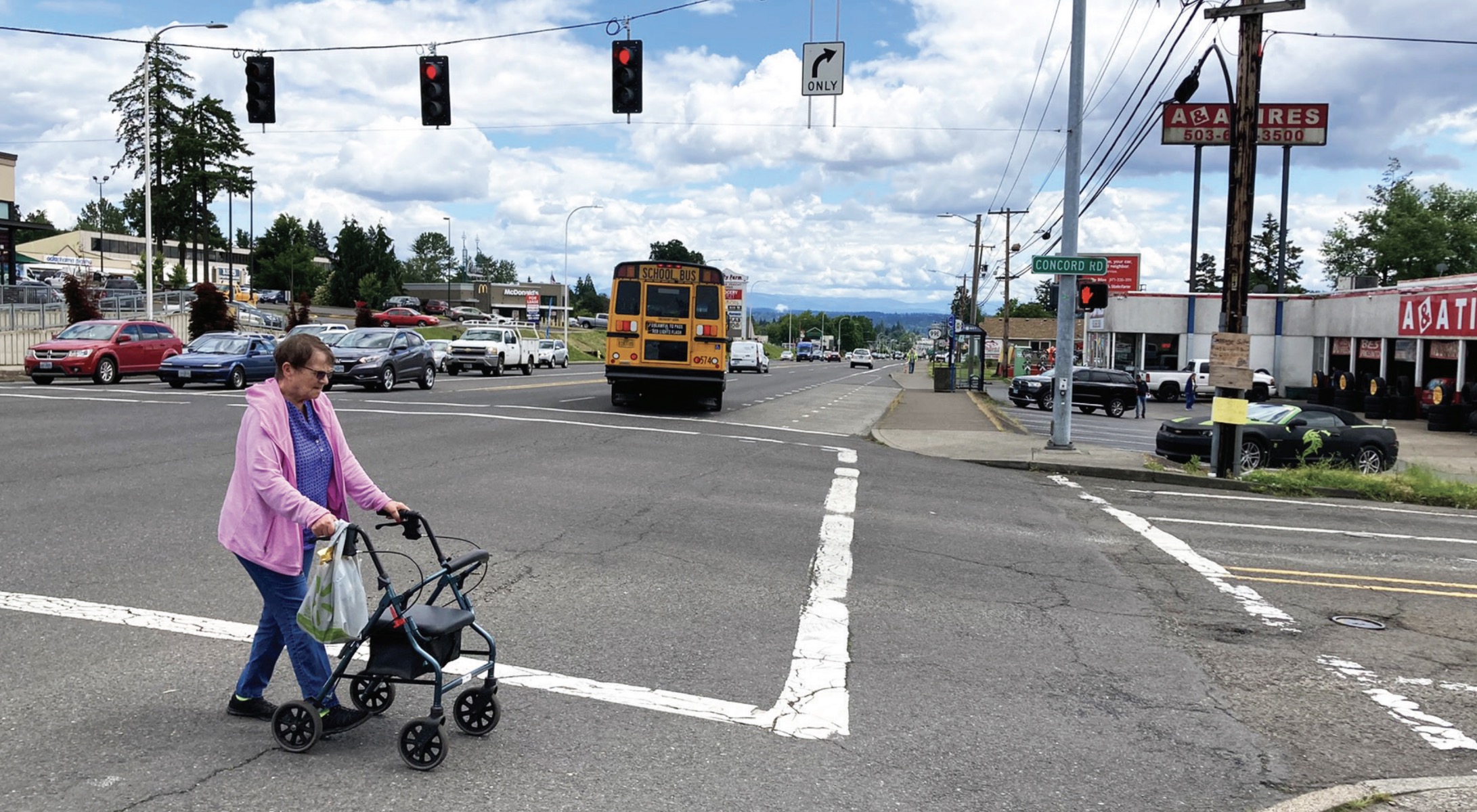
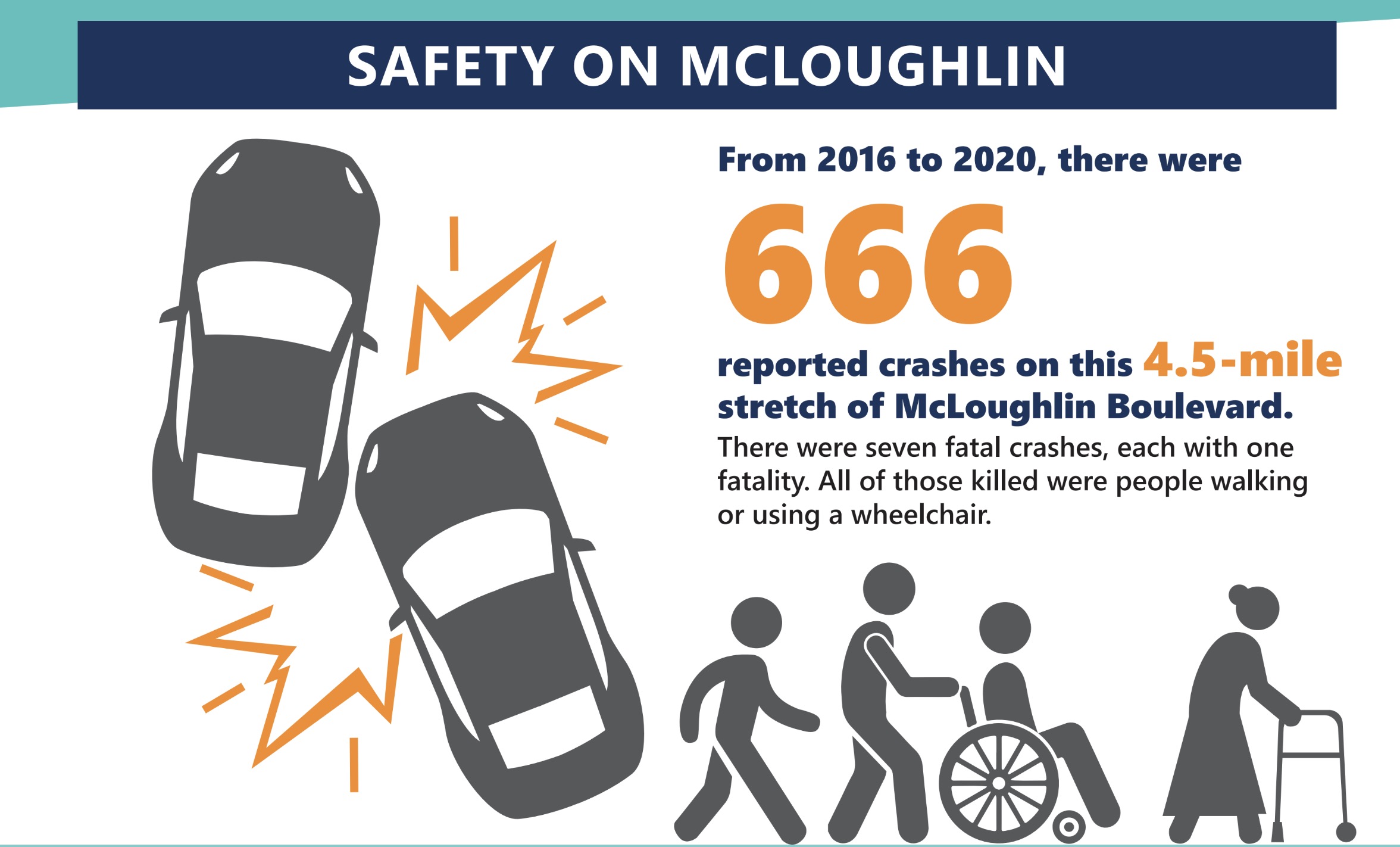
Believe it or not, that was written by the Oregon Department of Transportation. It’s an excerpt from the just-released draft version of their McLoughlin Boulevard Investments Strategy (you might recall our report on this back in March). It’s a joint effort between ODOT and Clackamas County to stop the bleeding on a 4.5 mile stretch of McLoughlin Boulevard (aka Highway 99E) between Milwaukie and Oregon City.
Despite being built as a highway solely for driving cars and trucks, McLoughlin serves as a main street for several cities and it’s the most important commercial corridor between I-205 and the Willamette River. And as you’d expect, it has a very sad history of crashes. In the past five years, seven people have been killed in crashes on this stretch of the road — all of them were either walking or using a wheelchair when hit. From 2016 to 2020 there were 53 crashes involving people walking and biking.
An excellent explanation of orphan highway.When riders dress like this, you know your road is unsafe.That’s not a great number.Photos and graphics from the draft report.
This investment strategy is the result of a year of outreach and planning work from dozens of county and state officials and advisors. And unlike other general road plans I’ve seen over the years, this one focused specifically on how to make bicycling and walking safer. The work done by this group will ensure that projects in this corridor compete better for grants and state funding in the future.
The most important part of the strategy report are the specific project recommendations. These projects can now slide right into the upcoming Statewide Transportation Improvement Program because they’ve been vetted by the public and the project team.
63 projects have been identified in the report. For each one, ODOT has assigned a very general cost estimate and feasibility score, along with a prioritization label.
Some of the projects recommended as “key investments” include: restriping the entire corridor 11-foot wide general travel lanes, to provide extra space to separate the bicycle travel lanes; add vertical separation materials inside the buffer to calm traffic and provide a greater sense of safety; reduce speed limit to 35 mph; add a landscaped median to help manage speeds; remove right-turn lanes at intersections and stripe continuous bike lanes all the way to the intersection; re-install storm drain grates at street level to reduce bumps for bicyclists; a bike-only signal at Jennings Road where the Trolley Trail crosses the highway, and so on.
It’s a solid list and it’s comforting to see ODOT and Clackamas County come together to make safe cycling more of a priority. McLoughlin Blvd was built for car drivers and it hasn’t changed much in the last century. It’s woefully outdated and doesn’t reflect the needs of many people. This plan offers us a path out of the darkness.
Check the full draft investment strategy here. The project’s community advisory committee (“sounding board”) is set to discuss the draft at their meeting July 12th. Learn more about the project here.
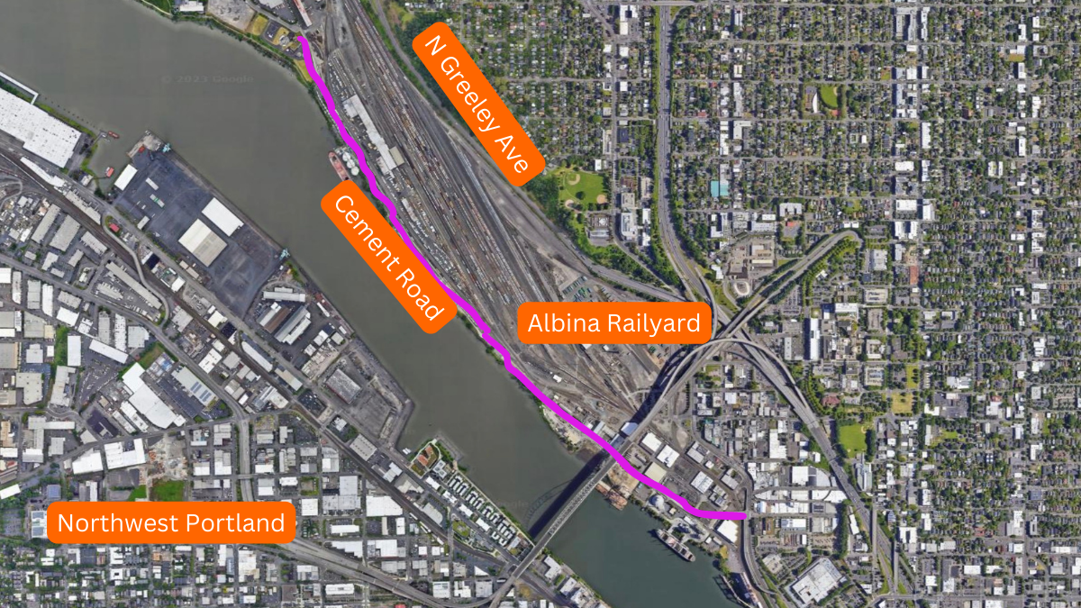
Looking south toward the Fremont Bridge on the Cement Road. (Photo: Jonathan Maus/BikePortland)
There’s an interesting new twist in the debate over the Cement Road. A combination of climate change and Swan Island business concerns have the City of Portland, once again, looking at the road as a viable option to Going Street.
For the uninitiated, the Cement Road is a fabled route that connects Interstate Avenue at the Fremont Bridge to Swan Island. Even though most of it is privately owned by Union Pacific Railroad, its flat topography and direct connection to the central city has seduced bike commuters for years. The only other way to get to the 200 businesses and 10,000 jobs on Swan Island is N Going Street — which has a steep decline down to the river and includes a few hairy crossings of wide roads busy with large freight trucks.
But the Cement Rd isn’t without pitfalls. Yes it’s usually safe and traffic-free, but there are some sketchy rail crossings. Then there’s the fact that it’s illegal and you are always looking over your shoulder for rail security guards. In 2014, we reported on a woman who says she was hassled and bullied by a UPRR security person for riding on it. If railroad security doesn’t scare you off, you then have to contend with North Interstate Avenue to connect to Greeley and make your way onto Swan Island via Going. In 2013, we shared the story of a Swan Island commuter who was seriously injured in a collision with a driver on Interstate — and he was only using that route because he’d gotten busted by UPRR security for riding the Cement Road just a few months prior.
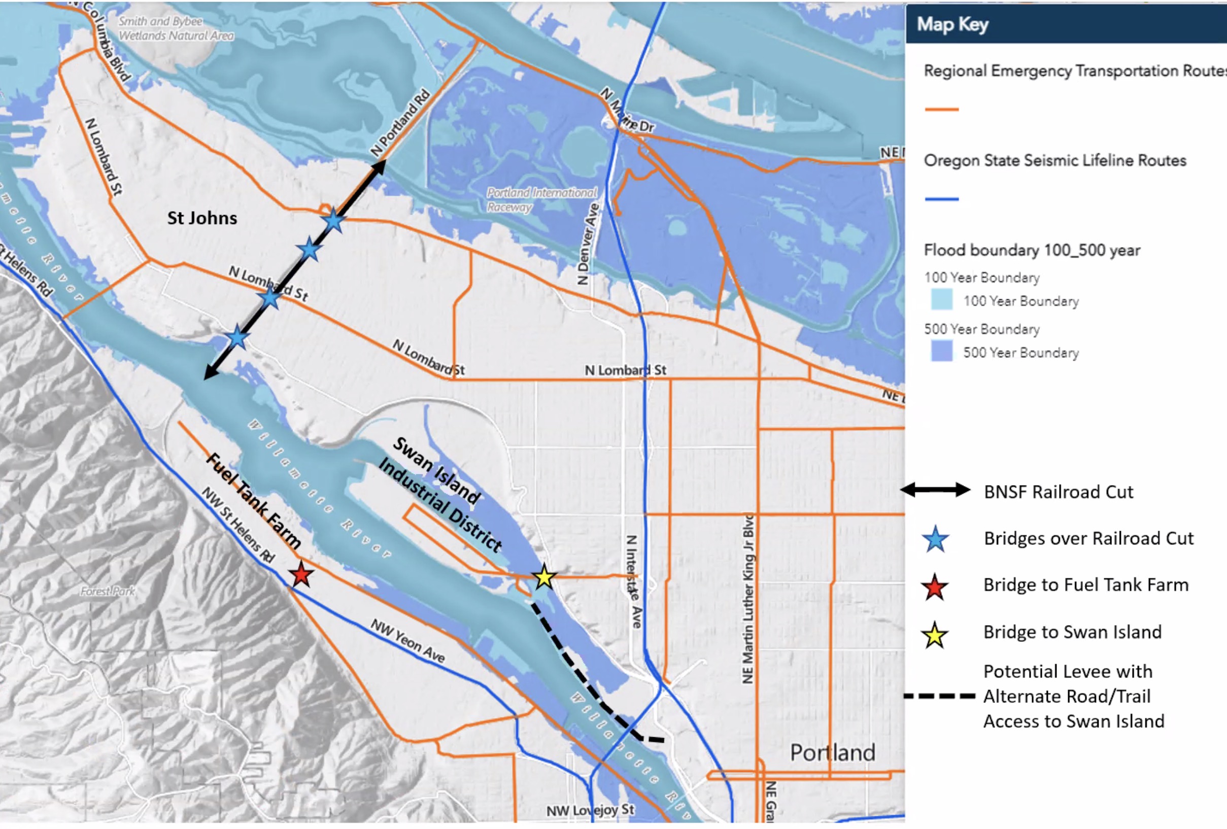
Now there’s a new idea in play: The Portland Bureau of Transportation (PBOT) wants to apply for a federal planning grant to assess the feasibility of building a new levee along the Cement Road alignment. That levee would then have a new road and multi-use path on it — just like we have on Marine Drive.
Flood map shown at Portland Freight Committee meeting today. Black dotted line is potential future levee and path.
This proposal was fleshed out in public for the first time (to my knowledge) at a meeting of the Portland Freight Committee this morning.
PBOT Planner Zef Wagner said the Swan Island Business Association is very keen on having a second road into the district in the event that Going St. is impassable due to an earthquake or other situation.
“I have no idea if it’s feasible or not, but it seems worth exploring,” Wagner said at today’s meeting. One of the main reasons this idea has gained attention at PBOT is because of how a major flood could damage Swan Island and UPRR’s Albina Railyard. A 500-year flood map presented by Wagner at the meeting made it clear that if we had a major flood event, most of the area would be underwater.
“These 500 -year floods are no longer 500-year floods,” Wagner continued. “They’re really happening every 50 years now because of climate change. If what happened to California this last year, where they got torrential downpours, like worse than they’ve ever seen… If that happened to us, the river would rise and a lot of these areas would flood without a levee.”
“We have a whole levee system for the Columbia River corridor; but we don’t have anything protecting this area.”
“I think it is potentially a win-win for everybody. It definitely merits a look.”
– Jim Sjulin, 40-Mile Loop
The flood and the business association aren’t the only thing on PBOT’s mind. A new Cement Road would also give them the chance to finally realize the vision for the North Portland Greenway Trail. That plan to extend the Eastbank Esplanade north all the way to Kelley Point Park, calls for a path along the Willamette and the Cement Road was always the preferred alignment.
Trails advocate Jim Sjulin is the person who suggested the idea to Wagner. “I think it is potentially a win-win for everybody,” he said in an interview with BikePortland. “It definitely merits a look.” In addition to preventing a flood, Sjulin thinks a levee could keep toxic railyard runoff from going into the river.
If PBOT ever embarked on a project like this, they’d have to navigate UPRR officials and freight truck advocates. At least on member of the PFC thinks it’s a bad idea. Committee member Bob Short, who works for building materials company CalPortland, said it would be a bad idea to “encourage pedestrian and bicycle traffic in an area that’s mostly used by trucks.” He also said PBOT shouldn’t re-litigate an issue he feels was resolved 20 years ago. “Why waste your money on something that ain’t gonna’ happen?” he told Wagner.
Wagner then pointed out that if it was ever built, there would be no mixing of trucking and bicycling traffic. “If this was going to happen, it would be a true mega-project. It would be full reconstruction of a new road.”
What about getting UPRR to play ball? Wagner thinks that dynamic has shifted in the past decade because the Albina Railyard isn’t as important to their business as it used to be. “I’ve also been told by Union Pacific and by people who talk to them, that things have changed.”
Whether or not they’ve changed enough to finally unlock the full potential of the Cement Road and open up an exciting new connection to north Portland remains to be seen.
PBOT will likely apply for a grant through the Biden Administration’s PROTECT program. The application would be due next month.