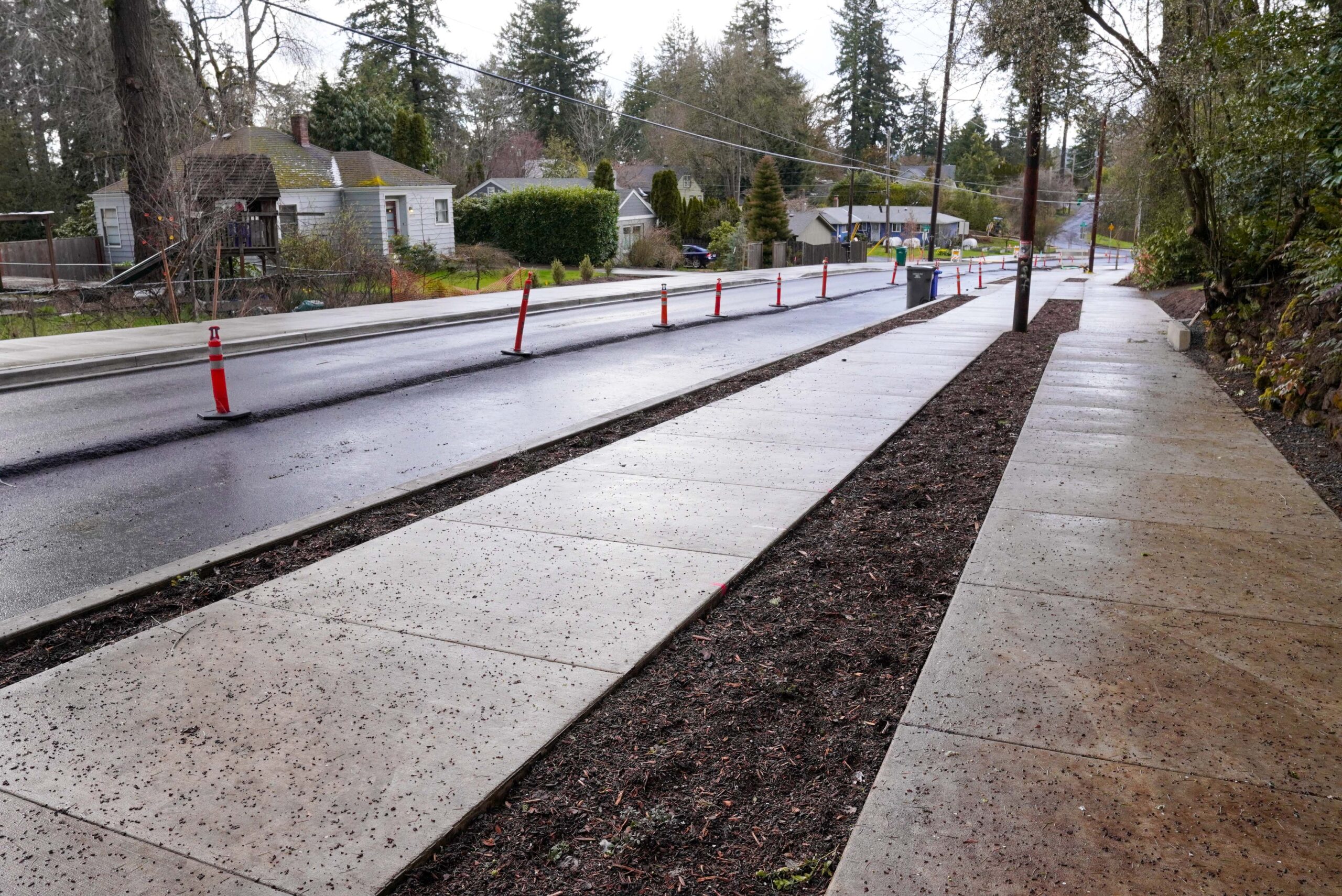
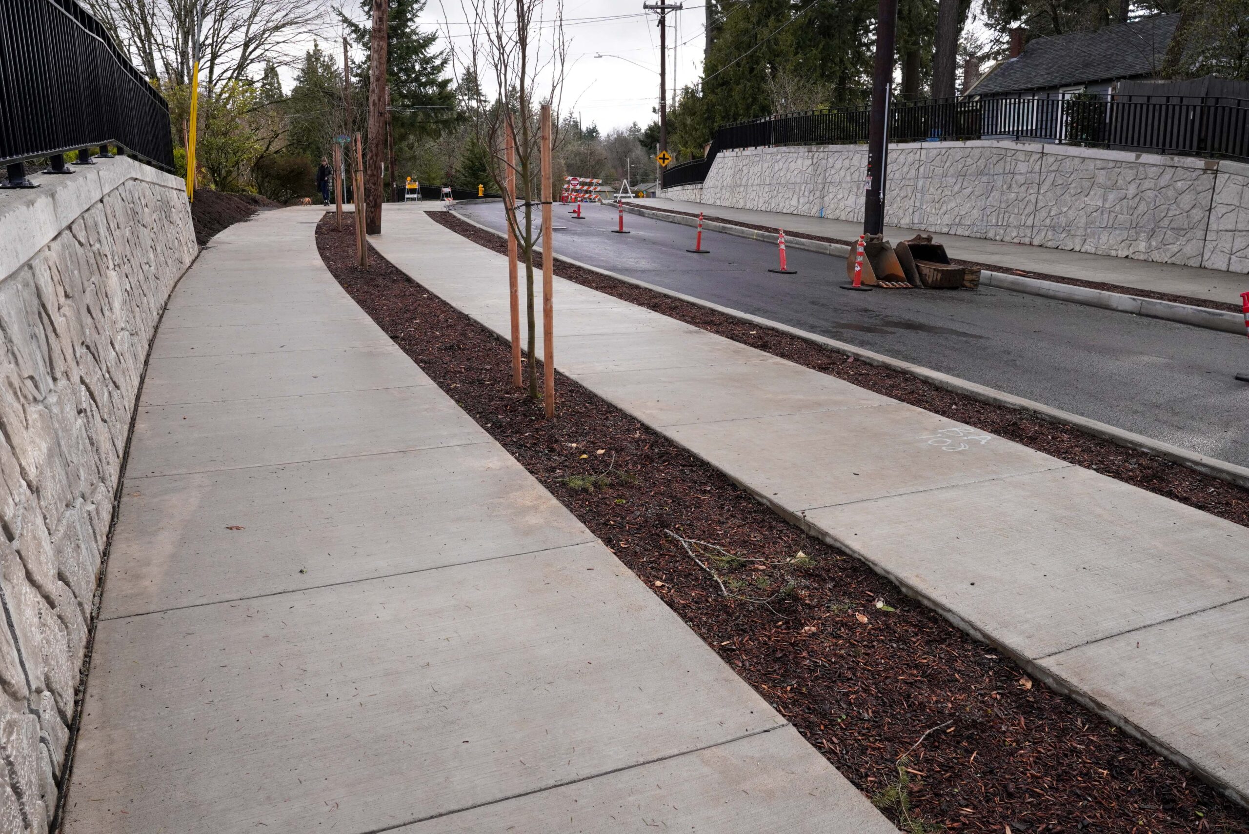
It’s been almost two years since construction began on a complete rebuild of Southwest Capitol Highway. The $27.5 million project updates a one-mile stretch of the road between Multnomah Village and Barbur Blvd/I-5 from a two-lane cross-section with no shoulder into a complete street with sidewalks, separated cycling facilities, new crossings, massive stormwater management features, and more.
Last week I took a look at this street for the first time since construction began and was astonished at what PBOT has built.
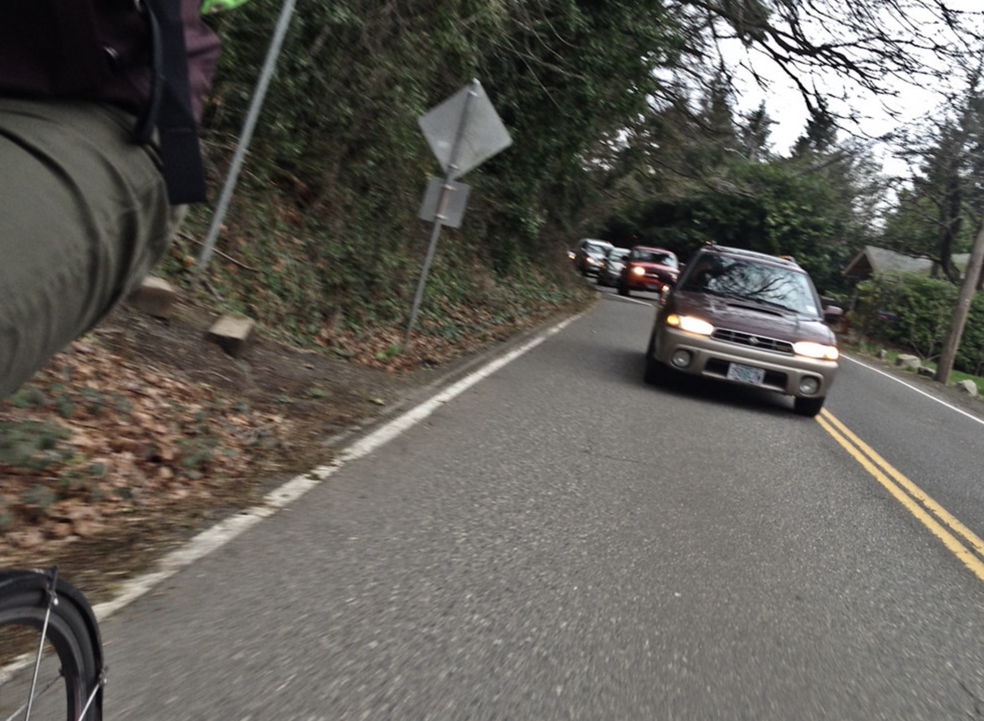
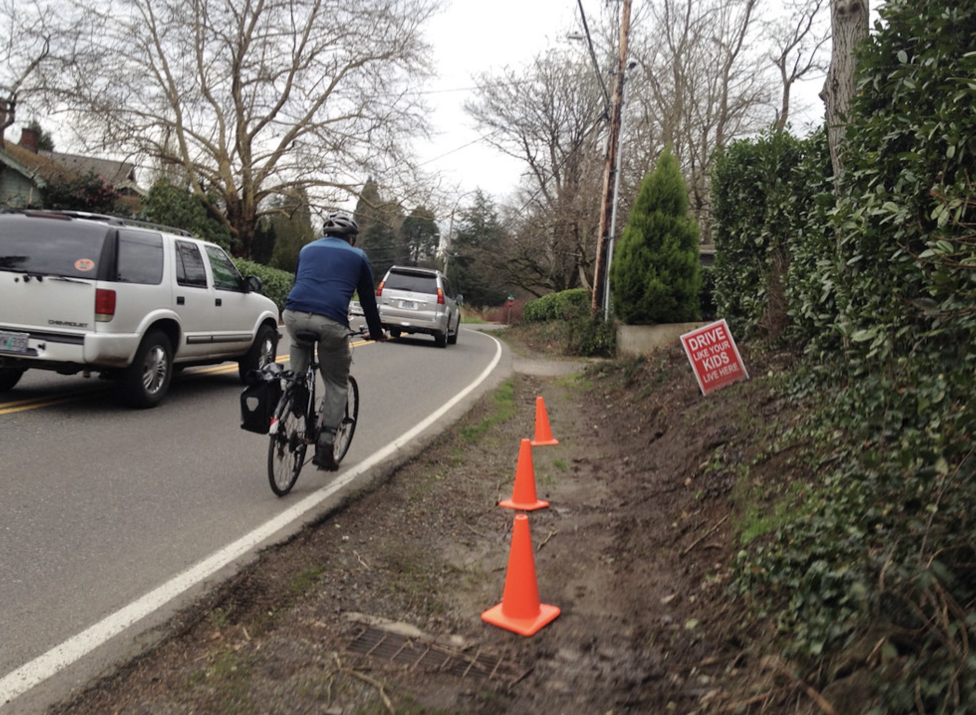
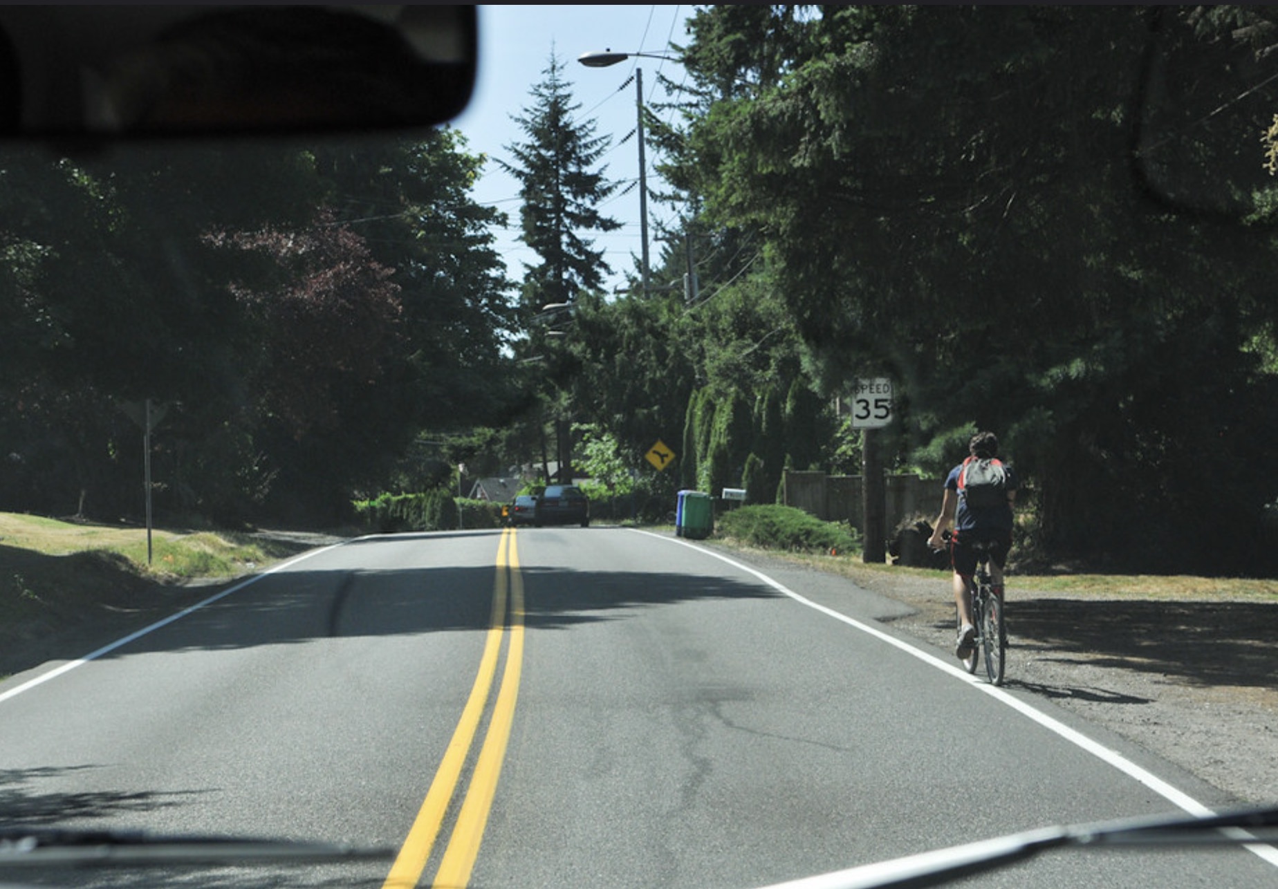
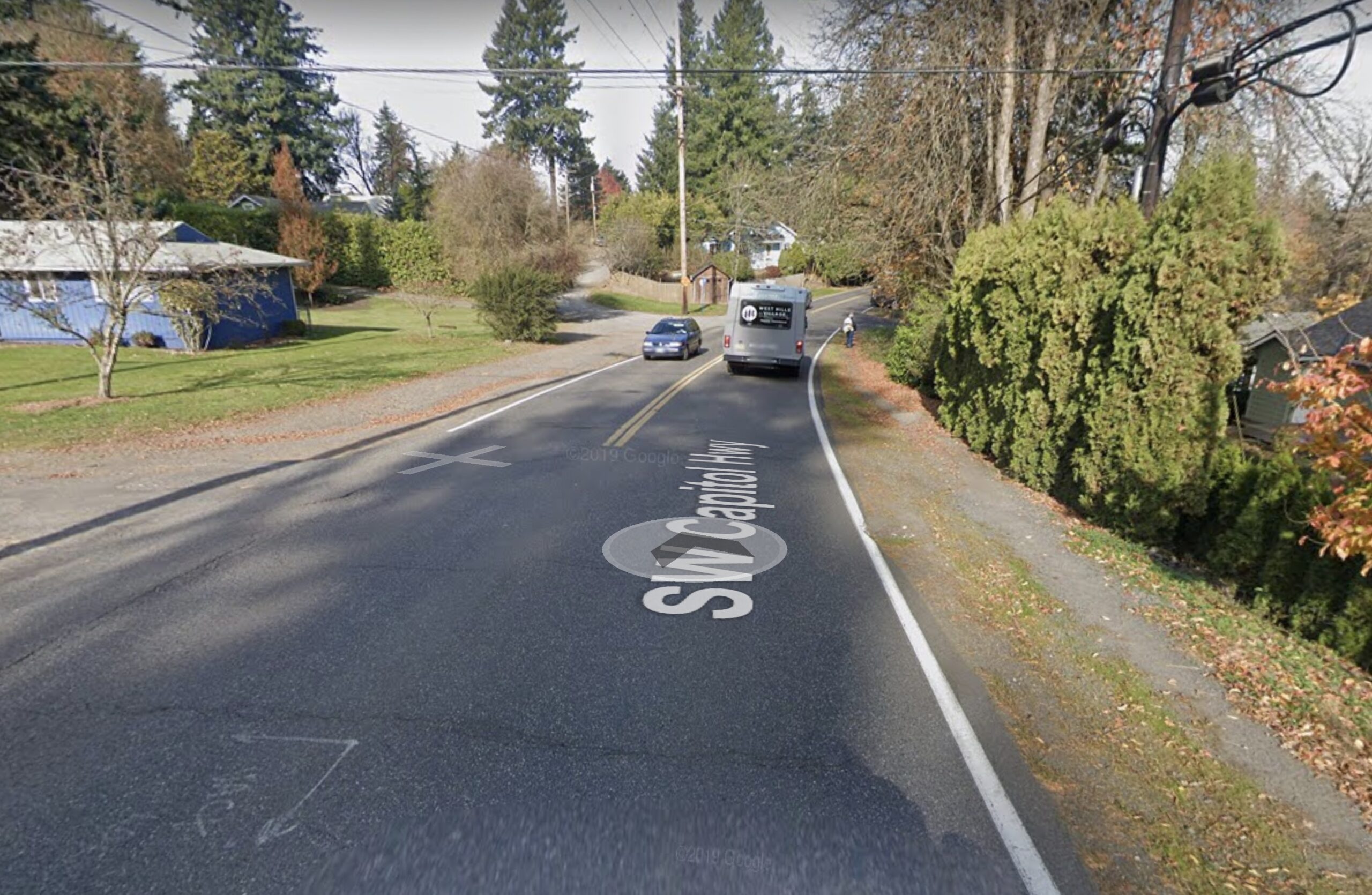
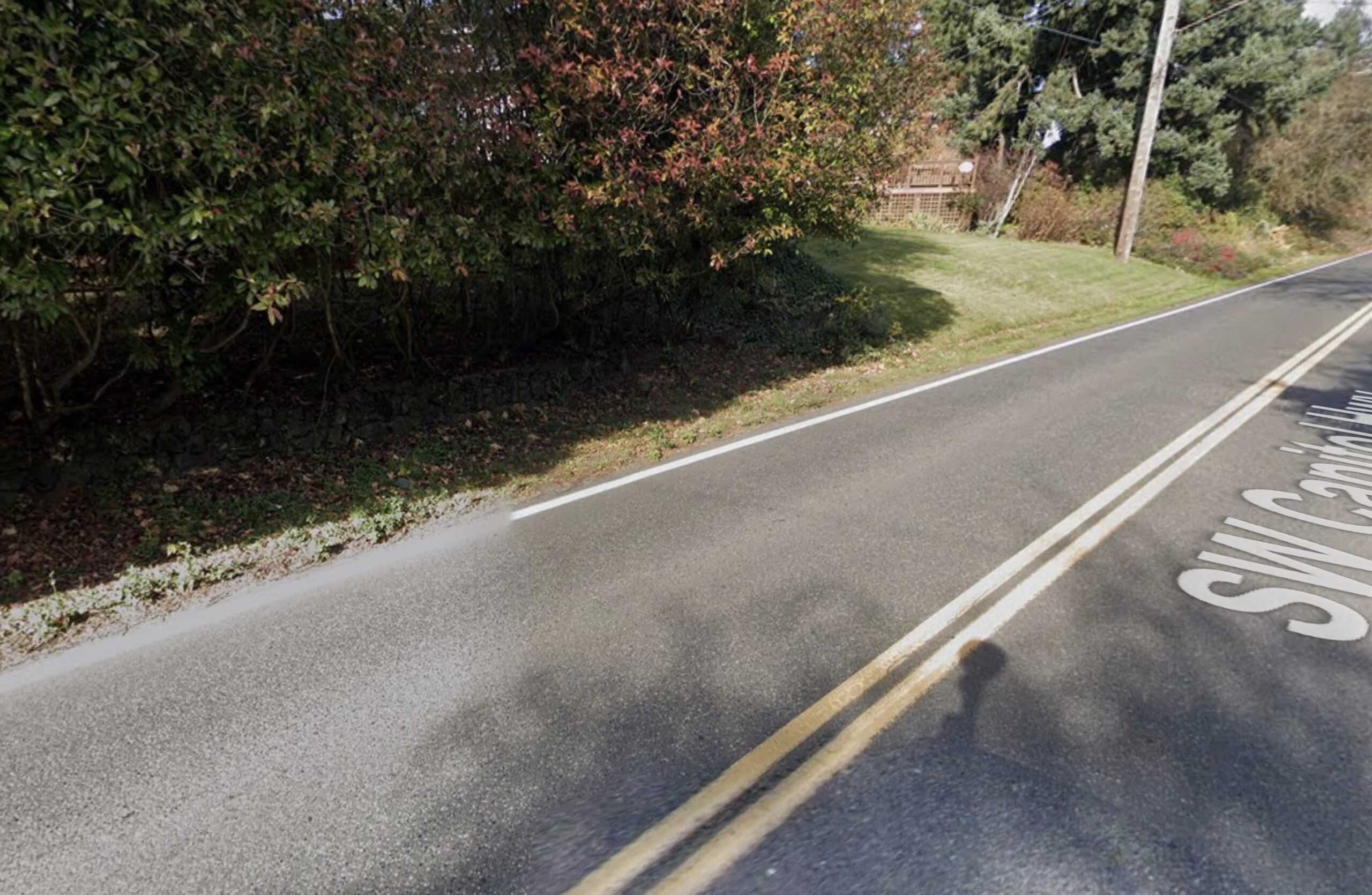
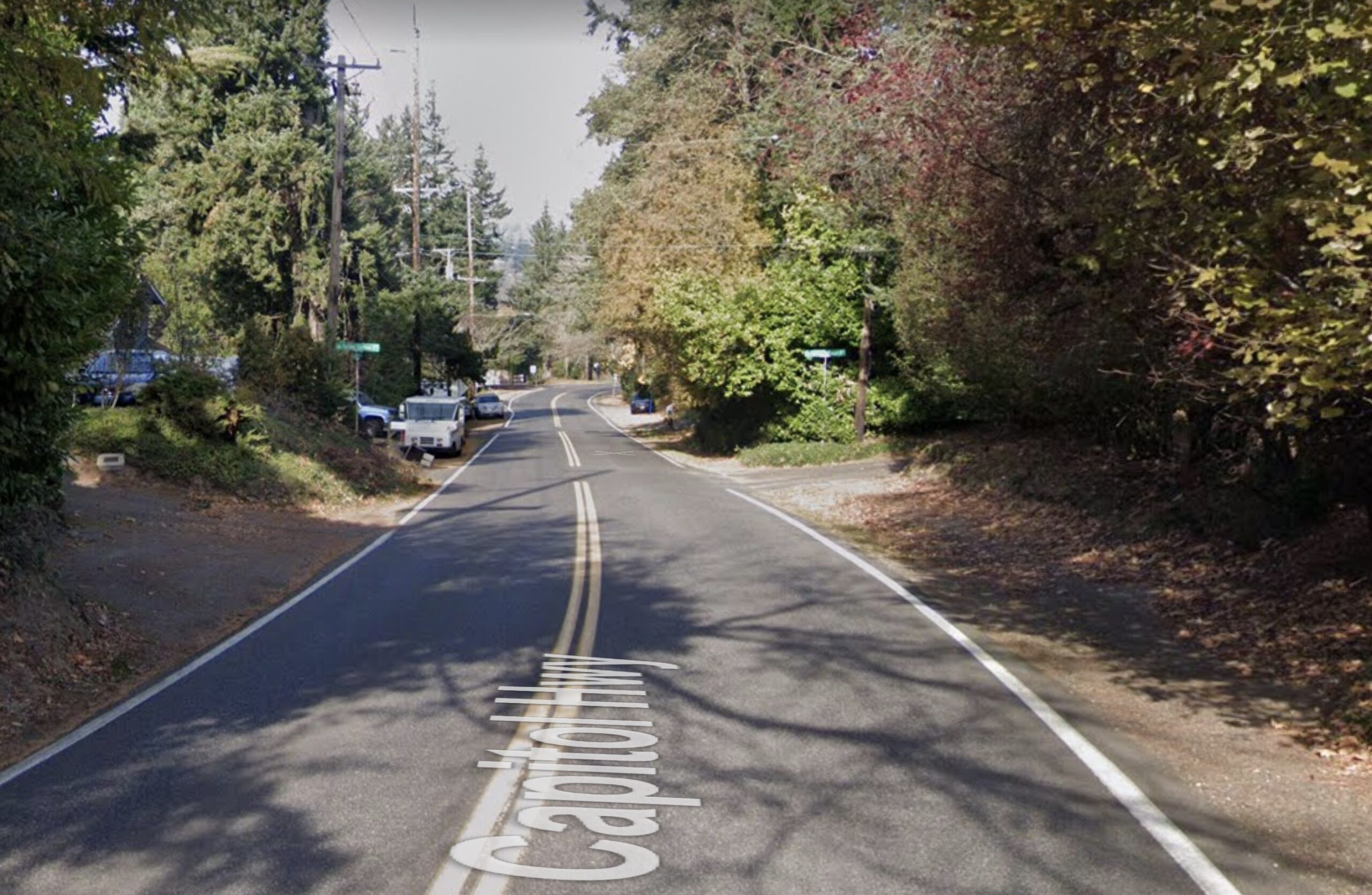
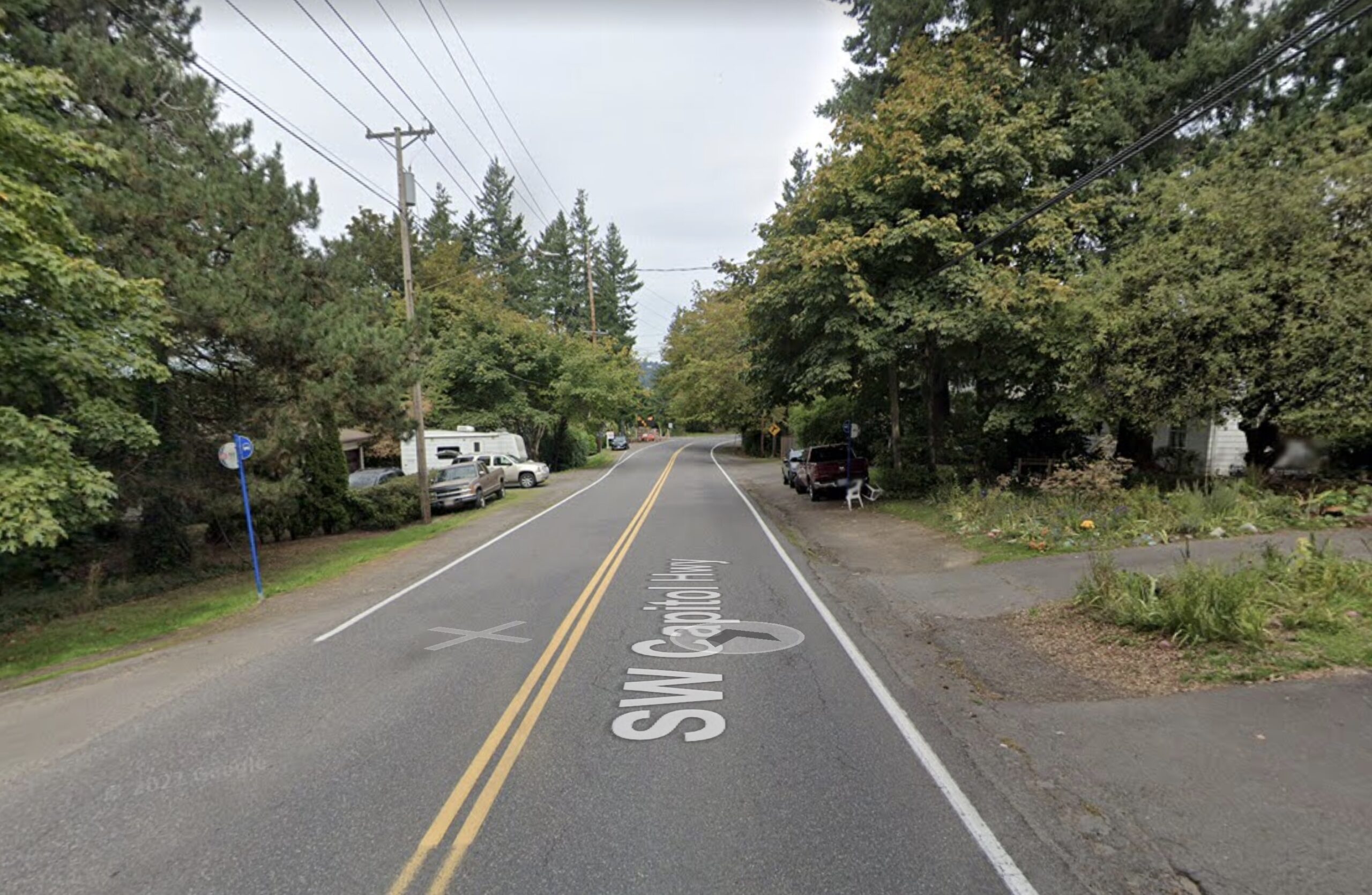
I rode this section with a local advocate back in 2015 and we clung to the edge of the road as drivers flew by. The sightlines were bad and there was nowhere safe to ride (see below). Now the remade street is nearly complete and it’s unrecognizable from what existed before. I don’t recall ever seeing a project where PBOT and partner agencies literally cut into residential lots and yards on this scale to improve a street.

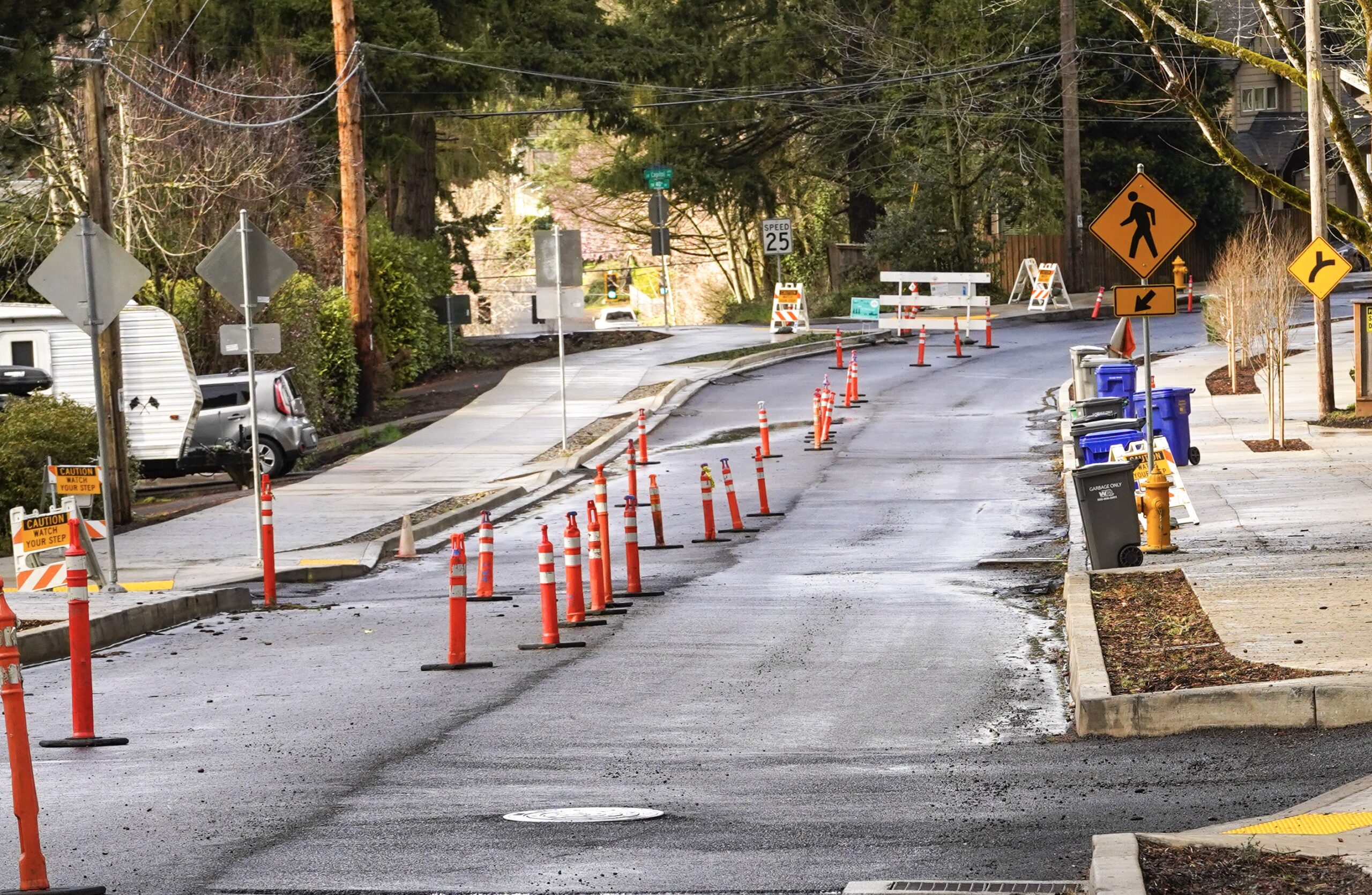
Even with construction equipment and closures in effect (it is scheduled to be done by this June), I saw lots of people running and walking dogs. I even saw a family with a little kid riding a bike. It was so amazing to see. Locals have wanted these changes for 30 years and it has finally happened.
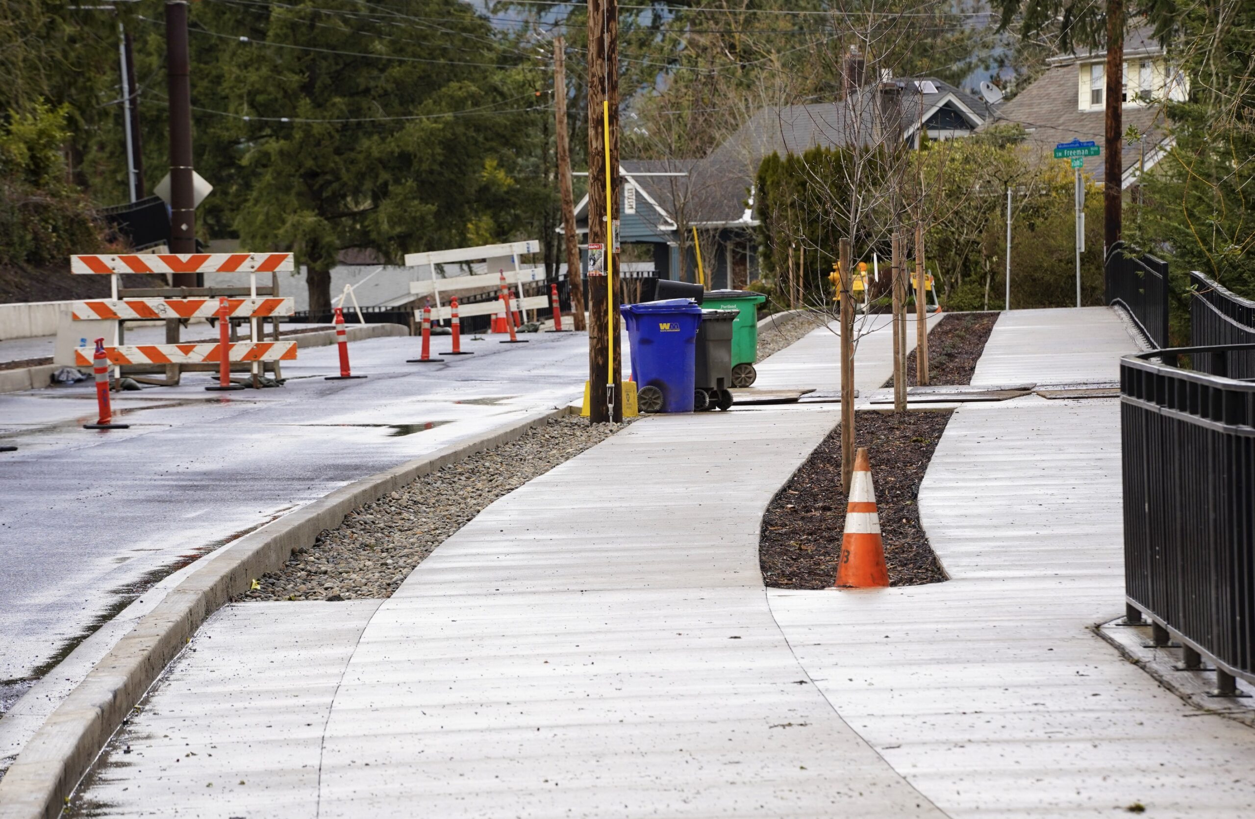
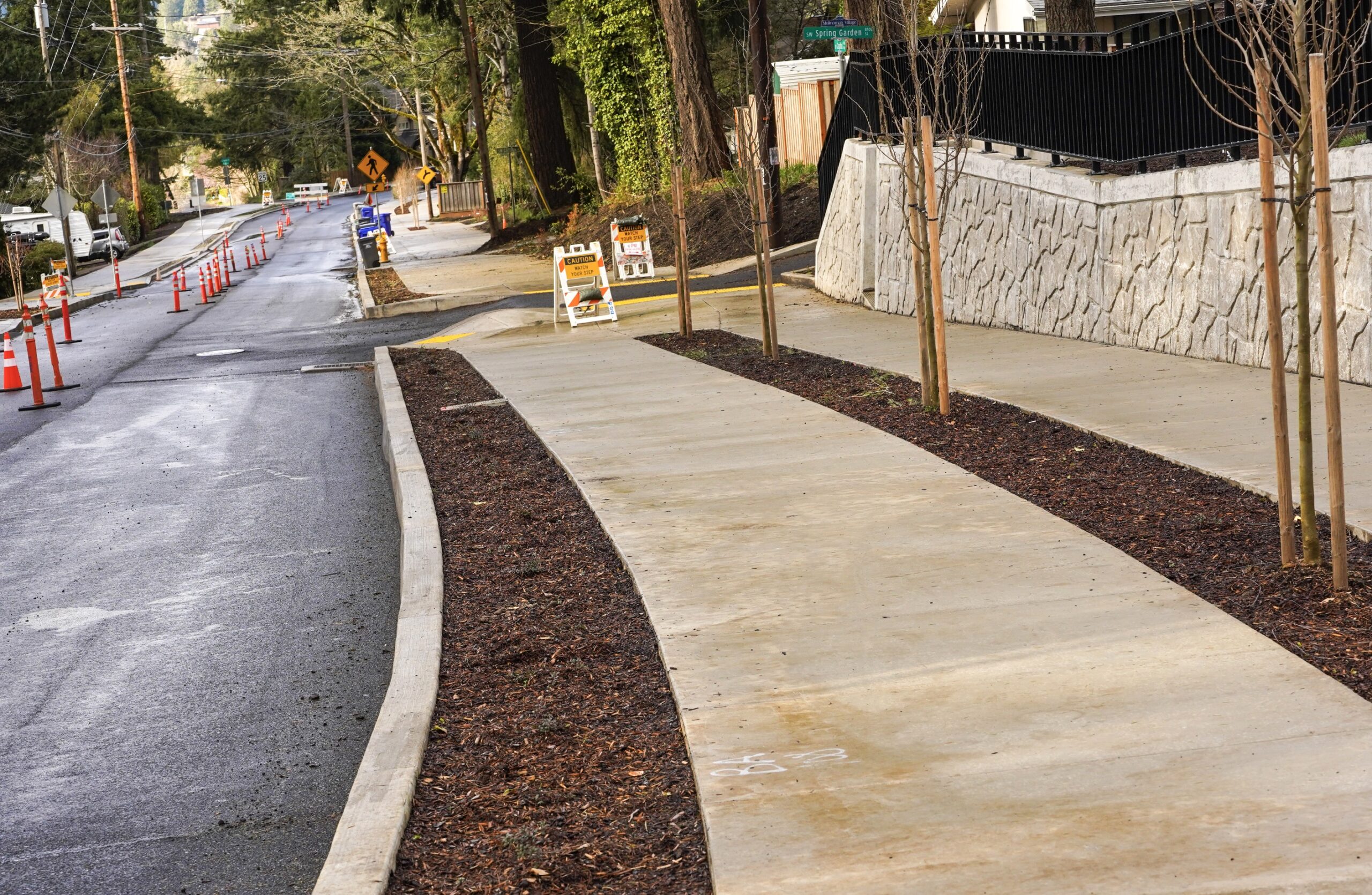
The project has added a sidewalk and protected bike lane on the east side of SW Capitol Highway and a multi-use path on the west side. That’s impressive enough, but what the City of Portland had to do to manage stormwater here is mind-boggling. 7,000 linear feet of stormwater pipe, over 3,000 linear feet of earthquake-resistant water main, three out of four large stormwater treatment gardens, and 13 roadside retaining walls.
It really is jaw-dropping to see in person and I have no doubt the changes will lead to transformational shifts in our relationship to this street.
Check out before/afters below, and stay tuned for details on the ribbon-cutting and official public opening expected in June.
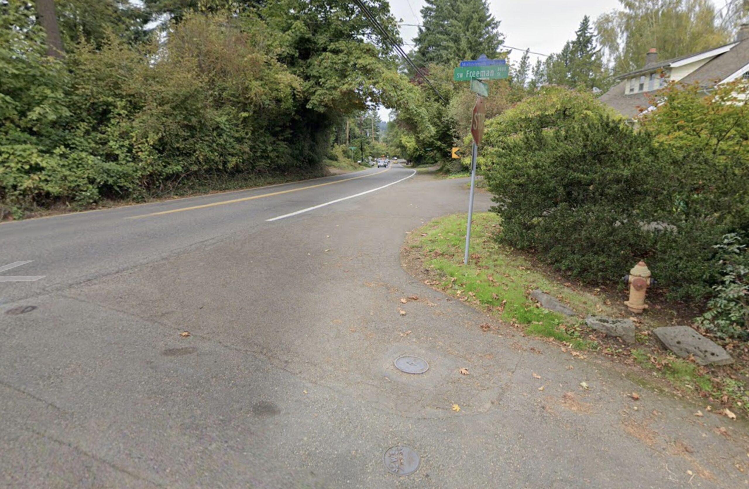
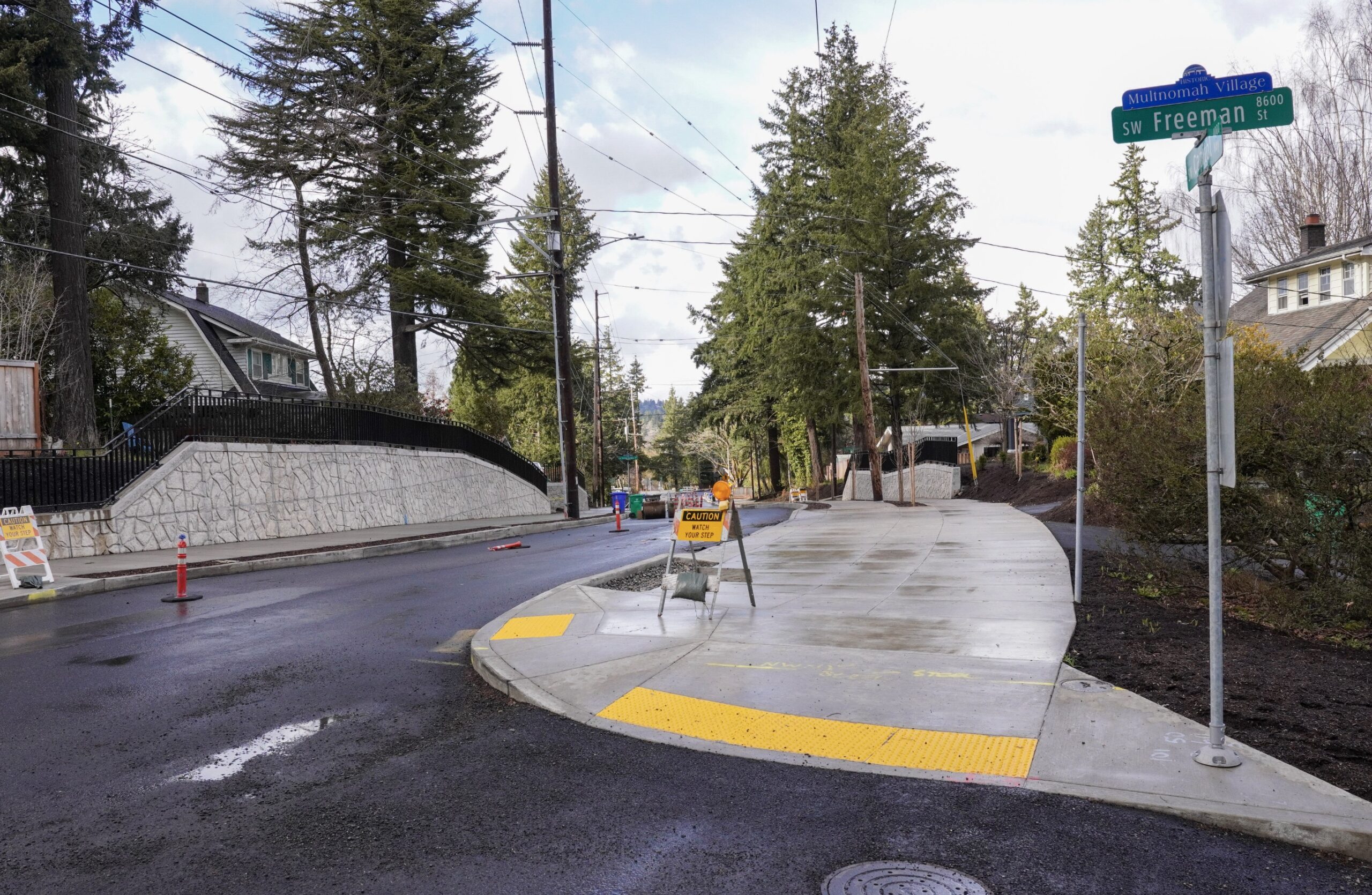
Looking north toward SW Freeman
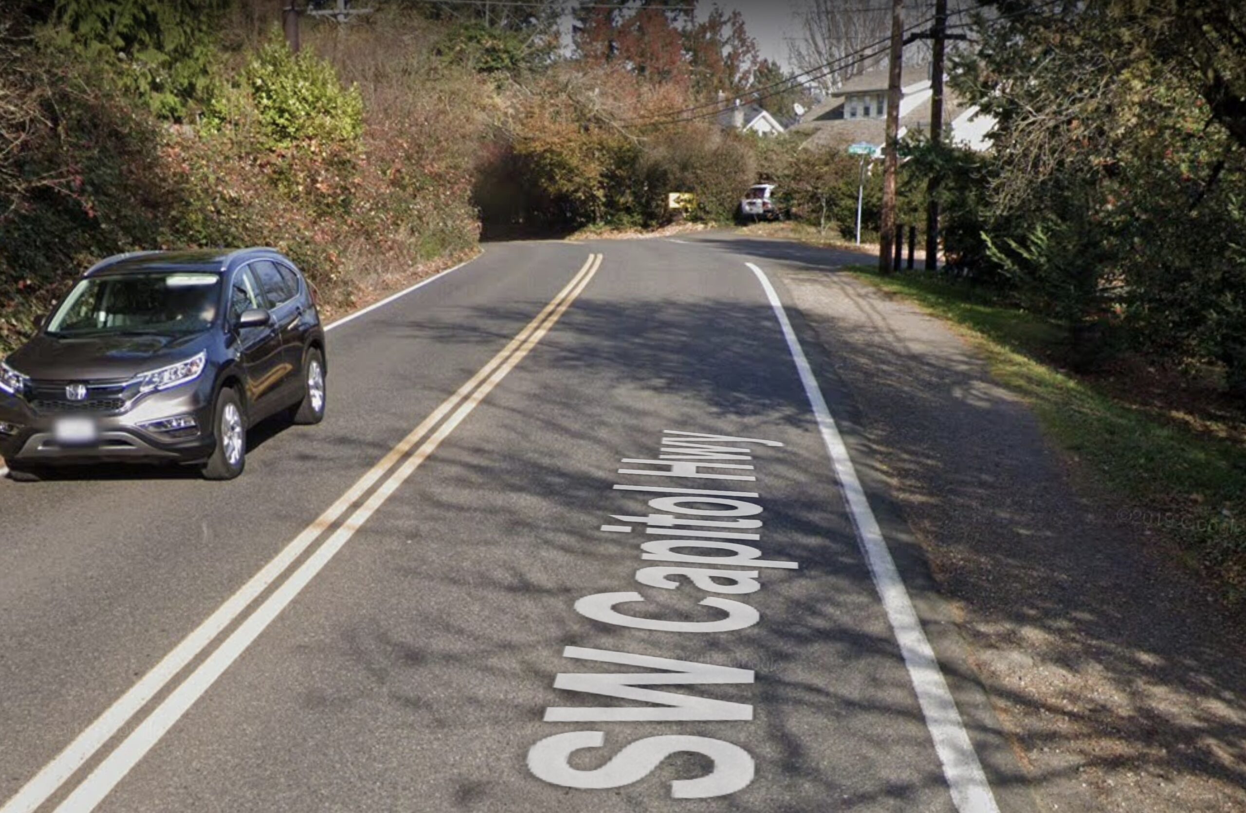
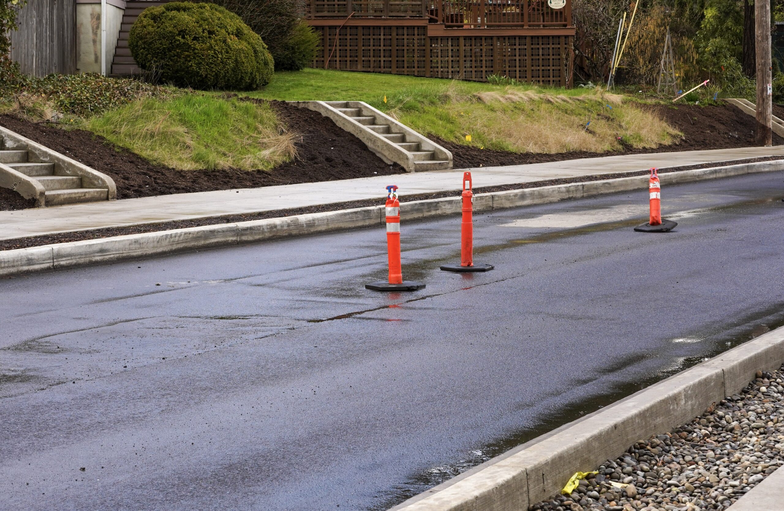
Looking north from SW Freeman
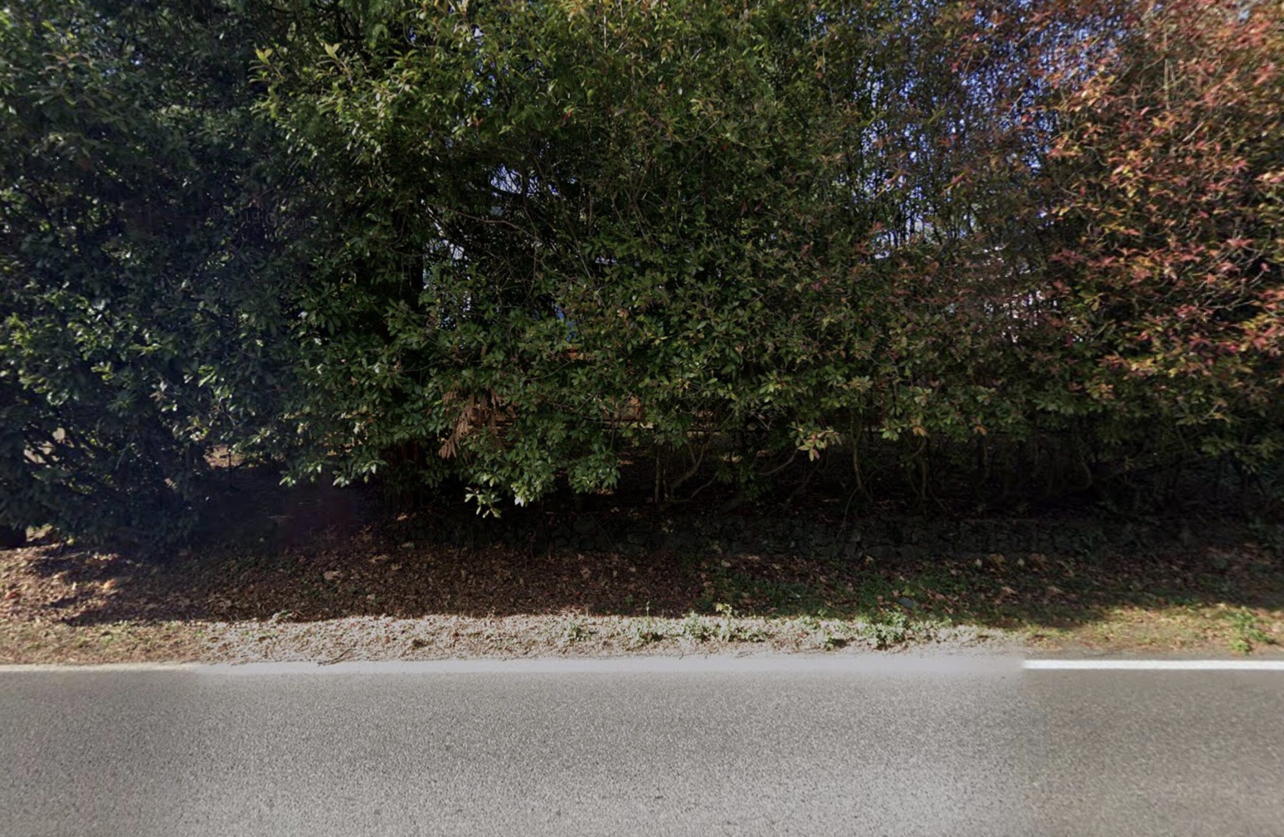
Looking south toward SW 41st

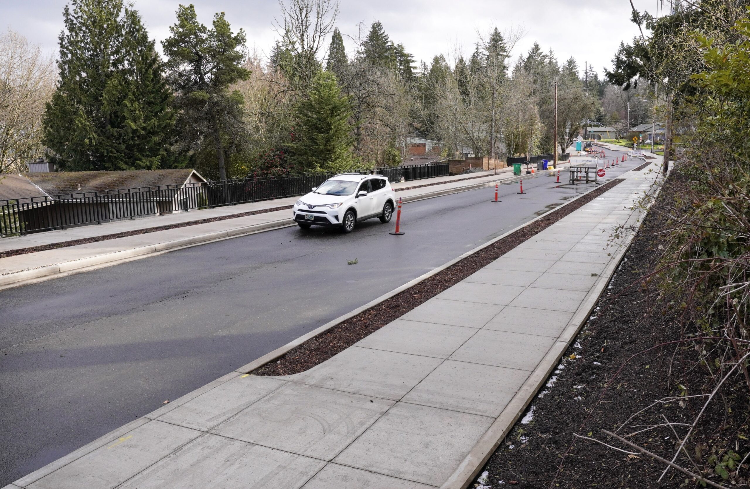
Looking north toward SW 41st
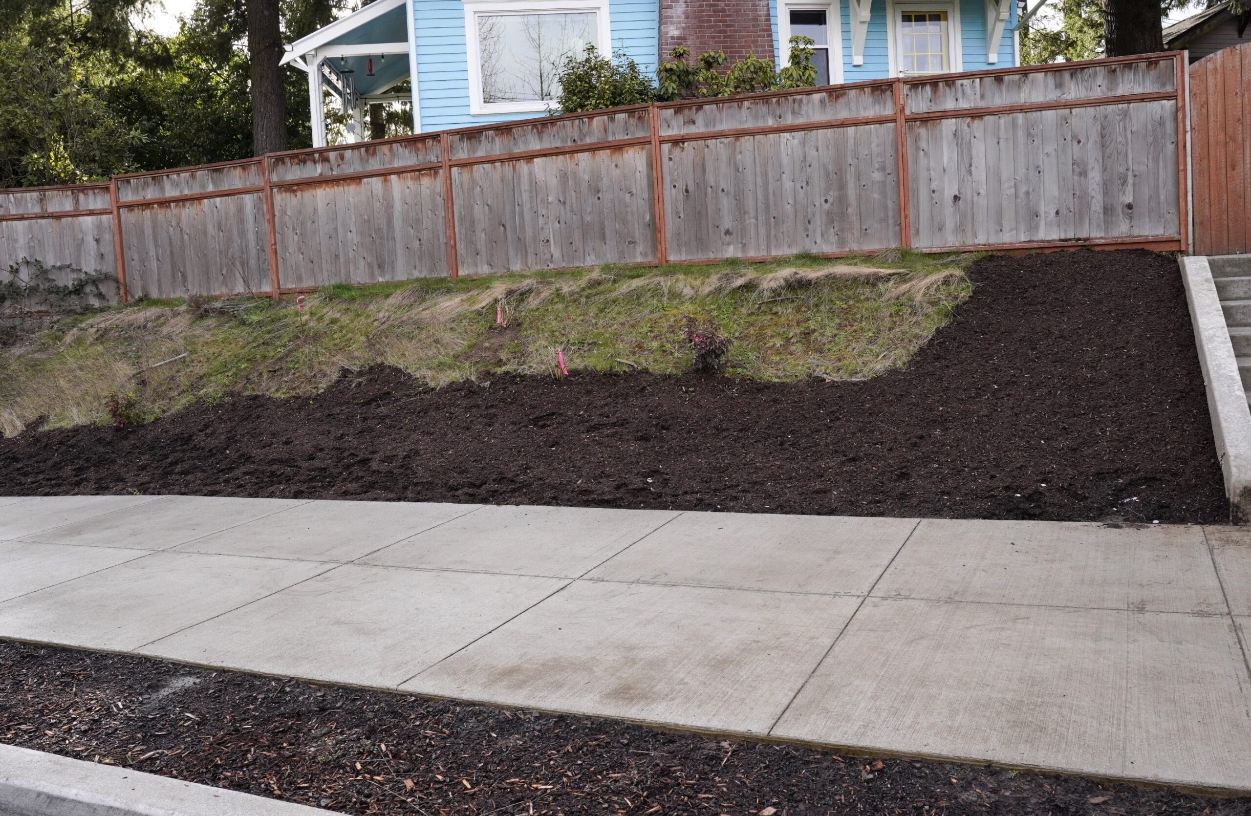
8629 SW Capitol Hwy
8702 SW 41st (Seen from SW Capitol Hwy)
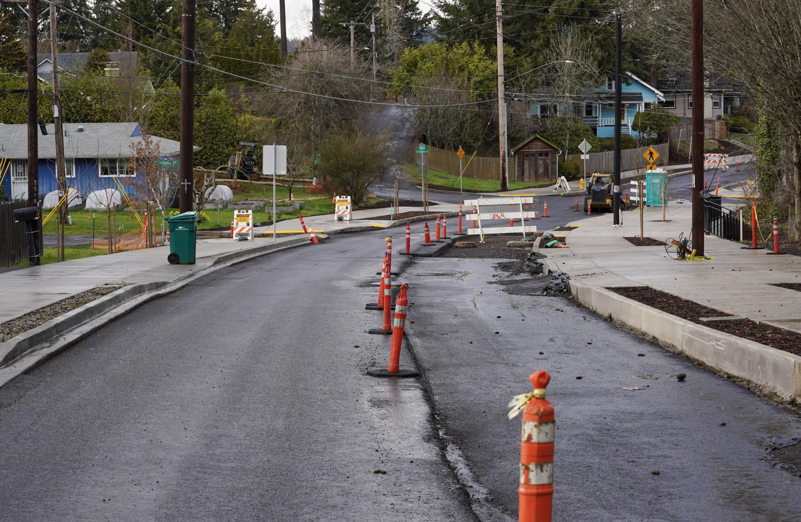
Looking north toward SW Spring Garden
Looking north toward SW 40th at Carson


Thanks for reading.
BikePortland has served this community with independent community journalism since 2005. We rely on subscriptions from readers like you to survive. Your financial support is vital in keeping this valuable resource alive and well.
Please subscribe today to strengthen and expand our work.
OK, I’m gona be THAT person.
This is a great project, and I’m glad it is done. It was badly needed, and I appreciate it as a pedestrian and a driver.
However.
This project is being used as the cudgel Development Review beats people with anytime roadside ped/bike improvements are asked for. “That was 27 million FOR ONE FLAT MILE! And now you ask for more sidewalks???? How much money do you want us to spend on your piddly walkers per day? Think of how much work needs to be done elsewhere!”
I do not exaggerate. Kurt Kruger flat out told a SWNI Transpo meeting ‘that 27-million-mile is what sidewalks cost in SW, and this project is all you’re likely to get for the next decade.’ He’s managed to convince city hall of that, apparently.
He dissembles. The cost is due to just about ALL of the city’s bureaus coming together on a megaproject – they realized that the amount of growth this area was projected to get would overwhelm an already insufficient car and connectivity collector and subsurface infrastructure… sewer, water, stormwater – all these things were old and in need of upgrade to handle growth. The bureaus realized if they pooled money and staff time they could do it all at once. THAT is what cost 27M, not the ped/bike infrastructure. Yes, adding concrete caused stormwater swales to be built, but this area, like many in SW, has always had runoff issues and needed these facilities anyways if the road was redone. They might have needed more capacity, or in different areas, but it wasn’t just because of the sidewalks. Raised curbs were a bigger culprit in my opinion.
Much of the blame seems to be that adding sidewalks meant moving the water mains; apparently having cement over them vs. asphalt is not ideal – cost of cement replacement after later pipe repairs, maybe? Except for a short stretch north of SW Spring Garden, it doesn’t look like water pipes were under what is now sidewalk. Making earthquake-resilient pipes is what Water admits it should be doing (and can’t afford) in ALL streets, so blaming it on ped/bike work is more sand thrown in faces. Water should be glad the work gave them the excuse and the ectra resources!
It is expensive to build in SW, and just adding sidewalks might have even been 20 million… I haven’t seen a breakdown of costs. I would also like to know how muchof that swale capacity is due to curb-directed runoff (as opposed to diffusing off sides of road into ditches and yards) vs. sidewalk impervious cover.
It’s a great project; it’s an example of the inter-bureau cooperation I’ve been screaming is necessary for years; it shows what the bureaus can do when they put their minds to it.
But as an excuse for why SW and hilly East Portland neighborhoods don’t get safe ped/bike infrastructure, it’s horseshit.
Comment of the Week!
The total allocated cost for rebuilding outer Powell Blvd, 4 miles between 99th/I-205 and 175th/Gresham city line is $132 million, mostly ODOT but also some PBOT SDC, or $33 million per mile, through water-logged swamp.
David, a lot of Powell has curbs. Few people walk or bike on the dangerous SW 45th / 48th from Garden Hike Road to Taylor’s Ferry.
YES please. Capital projects are almost always incredibly expensive, particularly when moving around utilities etc. BUT it only takes a few volunteers and planters to make a fairly robust protected bike network, which should be one of PBOT’s top priorities. Here’s a great example in Vancouver.
Were the two large water collection ponds on Multnomah Blvd built as part of this? There was one built between the post office and Multnomah at 40th Street and possibly a second larger one in the gully on the south side of Multnomah Blvd. (I haven’t had a chance to walk down and see what that one is.)
Is anyone familiar with the project and whether that is where the storm drains are routed from Capitol Highway?
Chris, if you click on the 1st link in the article, you’ll see I covered all that in depth. Subsequent articles documented building the stormwater ponds.
Lisa,
I followed the link and I still don’t have a clear picture of the scope of the project. An Overall plan few with a little context would be helpful. I am not familair with a lot of these streets, so the close-ups and street names are not very helpful. I have cross-checked against Google maps, but I am still not clear where the stormwater facilities are and how they interact with the sidewalk and MUP, and whether they are a positive greenspace (attractive, variety of plants, shade) or more of an engineered thing.
The storm water features are in at least three places. One is within 1/3 mile to the north of where the I-5 freeway meets Capitol and Taylor’s Ferry Road (that area is by the Barbur Transit Center). The other two storm water features are by the post office that is at the corner of SW 40th Avenue by SW Multnomah Boulevard (and there is a storm water feature on the north and the south side of Multnomah . SW Portland has very few sidewalks but the tax payers pay for Portland’s street sweeping that obviously avoids many streets in sw. There are loads of sediment in the Fanno Creek watershed. Portland’s sewer line has repeatedly dumped sewage into the Fanno watershed with bad pipes. Very few routes in southwest Portland safely accommodate riding a bike.
A total of four stormwater management facilities were built as part of this project. Going from south to north, there is a facility at the end of SW 42nd Ave, off of Alice, that treats stormwater from approximately SW Brugger St at Capitol, down to the end of 42nd Ave. Higher flows from Capitol would bypass this facility and continue along with additional stormwater to the second facility on Dolph Ct, about a block east of Capitol. Again, higher flows bypass at Dolph and continue to Garden Home and 40th Ave, to the final flow split location, sending metered flows to the north side of Multnomah Blvd, adjacent to the USPS site, while the highest flows would continue west along Garden Home Rd to the location of the largest of the four facilities, located on acquired properties and within the right-of-way on the south side of Multnomah Blvd. The four facilities manage the approximately 5 acres of the project footprint; and manages a total of approximately 50 acres from the project and surrounding areas.
My question is: had the road been rebuilt solely to address traffic, runoff and water/sewer lines, how much of this management infrastructure would have been built anyways? PBOT is pitching this as ‘sidewalks cost so much!’ when the proper frame is ‘runoff control and utility improvements, with bonus sidewalks!’
The project is more or less PBOT-initiated; however it got a big boost when BES and PWB decided to step up and bring their infrastructure up to proper standards. PBOT would not have had the funding to do the transportation project and meet any imposed stormwater management requirements. If they had, perhaps the stormwater components would have looked very different. As the project stands, the footprint is about six acres, but the total area now managed by the stormwater upgrades is nearly 50 acres.
An important point is that, for 95% of the project, PBOT didn’t “cut into people’s yards.” The sidewalks and bike facilities were mostly done in existing street Right of Way. But like most of SW Portland, adjacent property owners had taken over much of the ROW and built fences and used it as their private yards! Many were surprised (and some were annoyed) to find out where the ROW edge really was.
Thanks for clarifying that Doug.
Are you sure you are correct Doug? I was just reading over an earlier article I wrote which talked about “row negotiations for 90 easement/acquisitions.” Maybe it was all for pipes to the water gardens.
The lesson from this project is that it took a lot of cooperation between bureaus, the community, great project management from Steve Szigethy, a lot of volunteer hours from neighborhood association members.
It began with a letter from activist Marianne Fitzgerald to then city commissioner Earl Blumenauer–30 years ago. This whole project is a monument to the tenacity of a lot of southwest Portlanders and is a grassroots activism success story.
I guess I’m sensitive to the narrative being flipped to “oh the selfish sw Portlanders taking over public land with their fences.”
He is correct.
Which is fine, but I’m a “trust but verify” kind of person. Can I have a source, a link, a reason how you know, anything?
Doug is usually correct. When I worked for PBOT mapping out curbs and sidewalks 2000-2005, I remember how incredibly wide the ROW was for Capitol Highway for such an incredibly narrow roadway. There are others like it, mostly in SW, but a few in EP too. It was a common “best practice” in the 1950s to reserve large ROWs for important arterial streets, particularly in unincorporated county areas, so that stroads and even freeways could later be constructed – no one cared about stormwater runoff at the time.
An easy way to check would be to look at the quarter section cadastral maps (taxlots) that the city publishes – I rather doubt it has been updated to include recent ROW land acquisition for this project.
Well yes, I don’t know how long until they update for widenings. I did see some 2020 ones recorded on the Tax Maps, though, so perhaps there are just the few I mention in my reply to Lisa.
Goes back farther than that. Many roads in late 1800s were county roads with 60′ ROW easements. When annexed to Portland, those didn’t always get changed to 40′. There are areas with a 40′ ROW and a 60′ ROW, like SW Broadway Dr. Plays havoc with property owners and bureaus alike.
Capitol Highway follows the route of one of the older roads in that part of the county. It had a 60′ row in the 1920s or possibly earlier. Barbur Blvd replaced it as the highway when that was built.
It’s been a while since I’ve looked, but the old road surveys used to be available on the Multnomah SAIL site. (County GIS website)
I was basing that on a bunch of cross-sections that PBOT showed early in the project. It’s possible that retaining walls ended up having to be higher and wider, for instance. And there were probably “construction easements” to build a wall and then backfill behind it and then cede it back to property owner. So just an estimate from me. Looking at the aerials on Portland maps would be necessary, as another writer suggests. You can see the ROW edge currently, and then check the tax lot maps to see where ROW was acquired and when. But an initial look shows just one major ROW taking, on the east side of Capitol from Dolphin, half a block to Lobelia. 15’ at south end, tapering to a couple feet at north.
Thank you Doug.
Looking at PortlandMaps aerial view with the ROW lines overlaid, and then looking at the Tax Maps (Quarter Sections) it doesn’t look like there were many permanent dedications. (widenings). The only recorded ones I see are a 4′ dedication in 2013 on the west side from Primrose south for 120′. and there is a 2020 widening of 1.75′ on east side from Dolph to Freeman. Looking at the aerial, though the roadway was about 25′ wide in a 60′ ROW (70′ at Spring Garden), leaving 17′ on each side for sidewalks, bike lanes and walls. So mostly, no, they didn’t widen the ROW.
That said, there may have been a lot of temporary easements for construction, building walls and filling behind them, e.g., but no change in ROW width.
The project looks amazing! Can you add a graphic showing where this sits within the city and maybe some notes how it connects to walking/biking facilities in SW Portland? I am not very familiar with the SW neighborhoods, but I hear how underserved it is. This project looks impressive, but I am having a hard time understanding what impact it will have. Will this primarily serve the people who live along it, or is this more significant connector? PBOT’s project page is very low quality- I could not find any information about how this project fits intoa larger vision of walking/biking on it.
MaxD, I plan to write a followup to Jonathan’s post which will answer some of your questions, but I also have been covering it for a couple of years, so some of that I’ve talked about in other posts.
Real briefly, there isn’t much connectivity in SW (we aren’t on a grid) and good N-S routes are scarce. Cap Hwy will connect Mult Village to “the Crossroads” with Barbur. Because of ODOT jurisdiction the crossroads intersection is still dangerous, but PBOT has done safely improvements to the south. So, except for a couple of gaps, this very strategic cap hwy project will connect Hillsdale to Lake Oswego.
super helpful, thanks!
I think it is a bit unreasonable to suggest this will connect Hillsdale to Lake Oswego. You can’t even safely get from Hillsdale to Multnomah Village safely. Capitol Hwy has some seriously bad connections and requires a lot of vehicular cycling with confidence to stay on Capitol Hwy. There isn’t even a reasonable connection from Multnomah Village to the new bike lanes because of the bridge (which is going to cost millions to replace with no time frame https://www.portland-tsp.com/#/projects/TP02-0000126).
After PCC headed South, there is no reasonable connection to continue going to Lake Oswego.
This project has a lot of potential and has a lot of immediate value, but like most other PBOT projects it is far from being part of a bicycling network.
It could connect to Lake Oswego if LO put in protected bike lanes on Kerry Parkway by PCC Sylvania. LO widened the bike lanes on SW Boones Ferry Road last year from SW Kerr Parkway (near Lake Oswego High School) to SW Kruse Way. I simply asked for wider bike lanes in an email to the mayor of LO last year after I heard of the repave project and he complied.
A big issue would also be Country Club Rd. Biking in a shoulder of a wide 40mph multi lane road is a big no for me.
Maybe the next repave project for Country Club Road will result in more narrow car lanes with wider bicycle lanes. I emailed the Lake Oswego mayor and he complied to the request of wider bike lanes on SW Boones Ferry Road. The city added a southbound bicycle lane to Boones Ferry Road to the immediate west of Lake Oswego High School about six years ago and I think it was part of a repave project.
And to PCC.
I’ve just changed Jonathan’s top link to a more informative article.
I see that they have planted beautiful mature telephone poles into several sidewalks. Just curious, but why the divided sidewalks? For stormwater runoff?
Walking vs biking space
There are portions where cyclists and walkers share the path. Signage/paint isn’t all in place yet
I would love to know what folks living there think. I expect they’d be mostly positive.
Judging from all the people I saw out there using the sidewalks I’d say they frickin love it.
Yes, we walk the dog on Capitol Highway now, which was difficult before this project. I’m still positive that a cyclist coming down the hill is going to get creamed. It’s a great project for walking but not for downhill cycling.
Watts this was a bottom up, not a top down endeavor.
If in your subsequent reporting you encounter any folks who live along the redone street, please ask them! Positive reviews from immediate neighbors will make future projects easier.
As part of this project, new ADA sidewalks are being installed at SW 40th & Multnomah intersection . I’m curious what the plan is, as the new sidewalk seems to completely encroach on the bike lane at the NW corner, (Multnomah Blvd heading west). It doesn’t look like they’ve left space to re-stripe to add the bike lane back in either
You are correct, David. Cyclists are going to wipe out on that extended curb. It’s a disaster!
I’ve been wondering what the deal is there, too. Perhaps more raised bike lanes?
Regardless, just leaving it like that for the time being is a major cycling hazard.
Will PBOT put in a ramp to safely ride down onto the westbound bike lane? It goes downhill from the village all the way for the next one or two miles before SW Oleson Road.
PBOT said: “Believe it or not, this was intentional. We will be grinding out the stripes and re-striping with slightly narrower vehicle lanes to accommodate the ADA corners and the protected walkway/bikeway that will stretch from 40th to 45th. Unfortunately, it’s not good striping weather so it will look strange for awhile until we can get some warm, dry weather for striping on the whole project.”
That section of Multnomah from 45th to 40th does have very wide car lanes. I think they are over 14″ wide instead of 11″.
Huge improvement but wish the path was paved smooth. Absolutely hate the sidewalk style paths with gaps in the concrete and will likely stick to the road because of those gaps.
And many of the seams are already ragged. Much of the concrete work seems substandard and many of us have told PBOT but they don’t seem to care.
PBOT should be required to use the infrastructure they build, only way to make them care IMO.
There are standards for allowable variations in new pavement surface for highways and streets. Unfortunately those standards don’t seem to apply to bike infrastructure. When the Burnside Bridge was resurfaced the concrete finishers (unintentionally) put a wavy surface on the storm water channel next to the curb. That area is of course also the bike lane.
It’s good to point out that the cost of the Capital Highway project is spread over many functions and funding sources. It also points up the extreme importance of getting infrastructure right the first time because fixing something costs more. It’s so wasteful to go back and tear out the botch so you can do it right.
Who has standing to sue the city over the mess they allowed to be made of SW Gibbs? However much that costs it seems like a good place to make the point. There just aren’t that many ways to get up and down that hill on foot and not everybody can use a trail. It seems like an ADA violation on the face of it.
There should be standards for bike infrastructure! I guess we don’t have them b/c cyclists have no power, as usual.
YES, someone please sue over Gibbs! At least to force PBOT to give an actual, code-cited, legal reason for opposing pedestrian and bike safety, instead of their word salad of excuses that change constantly. As for standing, the 5th Circuit just affirmed that any medical staffer who could potentially look at a woman had ‘standing’ in a case, so any citizen who might ever want to safely walk Gibbs apparently has ‘standing.’
Paging Mr. Kocher…
ka-Chunk ka-Chunk ka-Chunk ka-Chunk ka-Chunk ka-Chunk ka-Chunk ka-Chunk ka-Chunk ka-Chunk ka-Chunk ka-Chunk ka-Chunk ka-Chunk ka-Chunk ka-Chunk ka-Chunk ka-Chunk ka-Chunk ka-Chunk ka-Chunk ka-Chunk
So dumb. If it’s for wheeled travel. . . why not build it that way?
What gaps are you referring to? The seams between sections of concrete every few feet?
Yes, maybe I’m overly sensitive or riding too fast or something but I can feel everyone of those seams riding over it, every couple of seconds, and makes paths like this and the Sunset Highway path really uncomfortable, physically, to bike over. Even on my big cargo bikes with big tires it feels rough, particularly on my back.
Have you tried a suspension seat post like the one from Cane Creek or a seat like the Spongy Wonder seat?
I have to agree with Adam; the standard for expansion joints seems to have gone from 1/8″ or so to around 1/2″, and just as deep. I have tripped on these by catching the lugs of some shoes in them, – yet if my sidewalk has 1/2″ defect I am forced to repair it… They also catch stroller wheels quite nicely.
The saw cuts in the concrete are required for controlling cracking. I believe PBOT requires these to be cut in after placement instead of being scored into the wet concrete because it minimizes the bump.
My point from long ago is that this project, while amazing, is totally overengineered and that a couple asphalt ribbons would have done the job.
Nearby residents were having continual flooding in their homes during rain storms. Two TriMet bus lines use Capitol and the 44 is planned to go from northern Wilsonville to north Portland which would make it a bus line with a lot of miles. Extremely few routes in southwest and northwest Portland have sidewalks and bicycle lanes. The Forest Heights neighborhood by NW Skyline Boulevard was built in the 1990s without making continued bike lanes and sidewalks on NW Cornell Road and NW Skyline Boulevard.
I live on this road. I hate this. The neighborhood has been ruined.
Why is it ruined?
Tons of trees and vegetation removed. Replaced with sterile concrete. Cars and busses now travel way to close to homes.
No, they don’t travel any closer. The roadway wasn’t changed at all, it’s just no longer a suicide zone for anyone outside a car. I’m sorry, but if you want to live in a natural paradise, you need to move further outside the city. Pockets of Portland acting like they’re still land barons living in their rural homesteads while being a 15 min. drive/30 min. transit ride to the major jobs center that is downtown is a big part of my issue with too many Portlanders’ mindset about the status quo.
Portland is a major city; having such poorly-developed and low-density areas this close to the center is a big part of the region’s problems.
Many of us want trees and other greenery in the city. We don’t all want to live on an urbanist concrete heat island.
No one wants to live in a concrete hellscape, which is why if you look in the photos above there is an abundance of median street trees that were put in. And you’d think if more people wanted tree canopy, there wouldn’t be so many sterile grass lawns around there…
Some people apparently do want to live in a concrete hellscape (or at least champion policies that have that consequence). Portland street trees don’t generally get very big, so every time we lose a big tree, it’s often gone for good, and Portland’s new zoning codes disincentivizes planting yard trees in many areas.
But mostly I was responding to the parent comment rather than criticizing this project, which, from a cycling standpoint, looks fantastic. It’s not at all clear to me if any large trees were removed, or if it was mostly brush being cut back.
A whole bunch of large trees were removed, alas. But as usual CoP says “We’re planting [a zillion] new trees to replace the many mature trees we cut down, so it’s all good.” But we are smarter than that.
Lots of invasive weeds were removed in this project. The photos clearly show adjacent property owners haven’t further removed the weeds.
Then narrow the roads, reduce lanes, make it easier to drive less, etc. The cities of the world that are actually prepared or preparing for the future—instead of trying to forestall the inevitable and live in delusion—are taking away space from cars and building more densely, and in so doing, preserving nature both within themselves and beyond.
I haven’t seen many examples of this as a successful strategy to increase tree canopy, but if it were a practical way to get more, bigger trees around, I’d be in favor.
Market urbanism is a rich white people way of life. One of the things rich white people (urbanist or NIMBY) like to do is to fight over who has more access to real estate capital while ignoring the poor people that their policies displace.
Yeah, it’s totally ridiculous. NIMBYs and the like sneer at the homeless for “it” being “their” fault and watch happily while their own real estate values skyrocket.
I live right in this area, and while I’m excited about this new infrastructure on the whole, it’s not going to do much to a wholly car dependent area. Lower commercial rents in the neighborhood center might allow a grocery store, hardware, bodega, newsstand, sandwich shop, etc, things of the like that serve all folks, and make this fantastic transportation investment pay far greater dividends, but that would require some real intervention into the market. So instead the main benefit is that some already well off (probably white) folk instead can walk to the pet cafe more safely now.
I think most people you characterize as “NIMBYs and the like” understand that homelessness is a complex problem involving many interconnected facets and that simplistic solutions are unlikely to succeed, especially in a state where governments have repeatedly demonstrated their inability to deliver on any level.
See you at the pet cafe!
I can sympathize with that, based on the photos. Lots more concrete. Houses that were hidden behind greenery are now fully exposed. The retaining walls are ugly in my opinion.
I do see trees planted, and planting areas that aren’t yet planted. My hope would be that after everything’s planted and growing in the r.o.w., along with people having a chance to do new planting in their yards, it will be much greener and softened.
PBOT has been criticized in the past for not providing trees. At least there are some here–don’t know if more are yet to be planted, or if more could have been incorporated.
I don’t know whether cars and buses are any closer than before, but they definitely must be more more prominent and noisier for surrounding residents given all the buffer being removed. I hope that will change with additional plantings and time.
The landscaping could be part of the follow-up article.
Oh no! People that live in a city actually having to reckon with what that means. Kind of like my neighbor thinking somehow he’s owed perfect silence after 10pm… *there’s a noise ordinance after all*
I’m not sure what kind of trees PBOT planted, but the planting strip is very narrow, so I’m guessing these are PBOT’s standard model TinyTree.
I use a brief part of it–from SW Alice to Barbur–on my commute from NE to PCC on days I am riding my cargo bike (my usual route via the cemetery, SW 12th, SW Lancaster, SW 27th, SW Stephenson, SW Walking Woods, and SW Hidalgo takes too much time on anything but a road bike) and am delighted it with so far. However . . . it ends at the Barbur/I-5/Capitol Hwy intersection, which was at one point (and presumably still is) one of the ten most dangerous intersections in the city. On top of that, the jug-handle change that they are planning to make to the intersection means that henceforth the majority of vehicles that cross the intersection going toward Multnomah Village are going to make a right turn at Taylor’s Ferry, which will put them in conflict with cyclists heading in that direction.
I’m not really sure that there is any realistic fix to the Barbur/I-5/Capitol Hwy intersection, but this situation is really unfortunate–particularly with the growing prevalence of e-bikes rendering cycling a much more appealing means of getting around in SW Portland.
Thank you Trebor, this is a helpful critique
Hi Trevor, thank you contributing such a nice comment! I wanted to make one small correction about your “ten most dangerous” intersections. I think you probably mean that is in the top ten percent of most dangerous intersections on the state index:
https://bikeportland.org/2022/06/09/sw-infrastructure-update-barbur-crossroads-and-multnomah-blvd-356109
Exactly Trebor. This is a fantastic addition to the neighborhood. People will be able to travel safely using several different modes within one neighborhood. But as a commuter route it is unconnected to any other part of the city. In that sense it is worthless. Without a separated path along Barbur Blvd, few people will be able to reach it.
You are right about the jug-handle, Trebor, except that drivers are ACTIVELY ignoring the new “No left turn” sign! Just stand at that intersection at any hour of the day and you’ll see car after car come down Cap Hwy, heading north into the intersection, and turn left onto the I-5 southbound ramp – just like before ODOT spent all that money to make this intersection “safer.”
This crossroads is an unsalvagable mess and needs to be completely rebuilt. ODOT’s performative tinkering has not changed and will not change anything.
Wow it actually looks bikeable and walkable now. I’ll check it out! Not bad for PBOT. 🙂
Now if we can just get PBOT to stop thinking plastic barrels and wands will stop bullets. Oh and stop thinking PBL’s are racist.
One can always dream. 🙂
An anecdote. When I was four-almost-five I walked a mile along this very stretch, from Marigold St to preschool in Multnomah-before-anyone-said-Village. 1976. I don’t remember the missing infrastructure; the only scary part I recall were untethered dogs several people kept along that route that would chase and snarl and nip at me when I walked by twice a day.