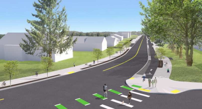
(Concept drawing of intersection looking southbound.)
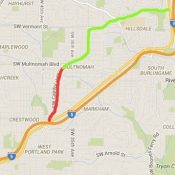
The Bureau of Transportation has issued a major update to the plans for a project that will add a protected lane for vulnerable road users on a one-mile section of SW Capitol Highway between Multnomah Village and Barbur Blvd.
A big change since the project was first announced two years ago is that the new 60% plans have removed the “green street” planter strips from the corridor. According to a statement from PBOT earlier this month, this decision, “allows for more separation between people walking and biking on the east (downhill) side of the roadway, and reduced grading impacts on the west side.”
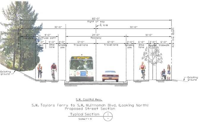
The current cross-section calls for a 12-foot wide multi-use path in the southbound (uphill) direction split between a four-foot lane for walking, a five-foot travel lane and a three furnishing zone. In the northbound direction there will be an 18-foot wide, grade-separated path split between a six-foot wide sidewalk, a three-foot planting zone, a six-foot lane for vehicles, and a three-foot furnishing zone. The center of the cross-section will feature two, 12-foot wide travel lanes.
Advertisement
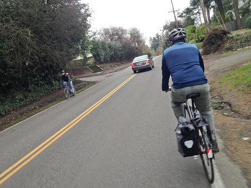
(Photo: Jonathan Maus/BikePortland)
These new plans also give us our first detailed look at how the street will look from a cycling perspective. Northbound, the lane will be constructed out of a black material to help differentiate it from the adjacent sidewalk. At each intersection, PBOT will install green-colored crossbike markings. In the southbound lanes the path will have markings on the concrete to keep people aware of where they should walk and roll. Cycling speeds will be much slower southbound due to it being uphill.
While this progress is welcome news, the project continues to move slowly (two years of planning and we’re still just at 60% design?!). This is the highest priority transportation project for southwest neighborhood advocates and they’ve been pushing for it since 1996.
Despite the design taking longer than anticipated (the city should get some slack here, given that streets in southwest have extraordinary stormwater management issues), PBOT says construction is still on track to begin next year and be done by 2020.
Learn more about this project at the official website.
— Jonathan Maus: (503) 706-8804, @jonathan_maus on Twitter and jonathan@bikeportland.org
Never miss a story. Sign-up for the daily BP Headlines email.
BikePortland needs your support.



Thanks for reading.
BikePortland has served this community with independent community journalism since 2005. We rely on subscriptions from readers like you to survive. Your financial support is vital in keeping this valuable resource alive and well.
Please subscribe today to strengthen and expand our work.
This looks great, and I’m very pleased to see no dangerous and poorly designed bi-directional or counter-flow bike paths on these diagrams. Capitol highway would be another bad location for use of a two-way, on-road path. Of course, the city may still abandon these plans and instead install an unsafe two-way cycle track at the last minute, on a whim (like they did in N. Portland).
In your opinion, which roadways would be good candidates for bi-directional protected bikeways? Any of them?
Oh, I’ll bite. Two-way sidepaths can be just fine, as long as there are zero intersections or driveways. They just don’t work well if they cross traffic in any way. Motorists simply will not look both ways down these things before they pull out into cyclists, especially if one happens to ride at faster than a walk/slow jog speed.
Mostly, that means they simply have (almost) no place in urban/suburban settings. I wish the people who implement them would come to understand that. Unfortunately, they only offer overly-narrow and door-zone bike lanes, which makes bike lanes not work well either.
Do you have data to back this claim up? It is intuitive but I seem to have ridden 15th NW in DC and Commercial street in Boston, both of which seem to function fairly well.
The Dutch would beg to differ, and they have the best cycling infrastructure in the world.
SW Naito is pretty good, along the park side. Not much else jumps to mind. 2-way has it’s place off-roadway (springwater, I-205, Highway 26, etc) and as an off-road bike-way connector between two disconnected roads – as in a shortcut or a path to get around an obstruction such as an overpass, freeway onramp, bridge, etc.
Columbia Blvd? Marine Drive? Portland Road? St Helens Road? Parts of Lombard?
Any street upgraded (or existing) for limited access (no driveways), auto through-put should include a bi-directional shared use path on at least one side, if not both.
Those are just fine, but they are not on-roadway. They are fully separated paths. This is my beef with 2-way bike lanes, they should only be where 10 or more feet of separation can exist, not by just moving paint around on the roadway.
Portland Road has a 2-way path, but it is separated by a significant buffer and not on the roadway. Marine drive where it has a 2-way path also has this off the roadway and separated by significant distance from the actual road, so it’s a path, and not a bi-directional bike lane on the road surface. Paths are fine where you can make them, along rivers, along railway beds, etc. A path on Capitol Highway that carved out an actual path off the road could have potential, but what’s the chance of that, so they should stick with the traditional bike lane alignment. Greeley is going to be a problem unless they go ahead and pave a bike path off in the grass, and off the road.
My point is if you are going to make bike lanes on a road, that’s great, let’s make bike lanes, one on each side of the road. Just don’t take a road where you can put down single-direction bike lanes on both right sides of the road and instead create a dangerous on-roadway two-way bike lane just cause it seems simpler from a construction or easement or city-engineering standpoint. Don’t do it unless they can put 10 or more feet of actual separation between the highway and the counter-flow bike path, and there are no intersections.
I’m curious, Jonathon, why you think the city should get any slack here if they’ve been designing this project for the last 22 years? They’ve always known about the runoff issues, since they maintain the sewers under contract with BES, and they kept getting funding to rebuild the roadway for years but never spent any of it. Or are you being sarcastic?
maybe i should have worded that differently. My intention was to let people know that there are specific variables in that part of town that make projects more expensive and more difficult.
You’re right. The local clay soils make it much more expensive to deal with runoff than for other parts of the city, as more land must be set aside for swales and runoff ponds. But it’s not as if any of this is new to PBOT, just that more challenging.
The project has not been in design for the last 22 years.
Actually, it has. But the original designs looked nothing like the present one – narrow shoulder lanes with or without sidewalks versus the current protected bike lane design package. This section of roadway has long been expected to be rebuilt, but the city has to satisfy both ADA and dealing with storm runoff.
If I’m reading the diagram correctly, the 3′ buffer between the bike lane and auto lane on the east side will be a different grade than the bike lane, which means it won’t be usable for passing or side-by-side riding. A 6′ bike lane is by itself insufficient for either of these things.
It seems like the progression for building bike lanes goes:
1) Any dedicated space (door-zone bike lane, gutter lane)
2) Bare-minimum dedicated space (buffered bike lane, multi-use path)
3) Safe dedicated space (protected bike lane)
4) Equitable dedicated space (double-width/triple-width protected bike lane)
We are currently on 3), which at least keeps people on bikes from getting killed. But for cycling to be on par with driving, we need to acknowledge non-solo trips. This means moving beyond the “commuter cyclist needs” mentality and looking at the needs of people traveling in pairs or groups. Nearly every other mode–driving, walking, transit–allow for people in groups to travel as a cluster and communicate easily to the person next to them instead of having to shout over their shoulders the whole trip. Being able to communicate while traveling isn’t just about improving the experience from an enjoyment perspective, it’s about safety too: parents knowing their children are keeping up, partners giving each other last-minute direction updates, friends asking to pull over because their bike just started making a weird sound. PBOT has acknowledged that greenways should be designed to accommodate these types of behaviors; what makes bike lanes any different?
(Even if you think riding two abreast is “asking too much,” you can’t deny that slopes–uphill or down–demand sufficient room to pass safely. Because passing WILL occur, with or without sufficient room, and while bike-on-bike crashes aren’t as dangerous as auto-on-bike crashes, they’re still a safety hazard, especially if one party is flying down a hill at 25+ mph.)
2012 & B. Carfree, you can see the constraints of the narrow right of way and how much PBOT has to pack into it but still be ADA, a bus route, and provide for storm runoff; widening the right-of-way is cost-prohibitive through the current land markets and they no longer can use eminent domain to force land sales.
Given a 24-foot space between curbs, the city is showing 12-foot traffic lanes. If PBOT added 4″ “fog line” striping 2 feet from the curb on each side, effectively creating 9-10 foot driving lanes, do you think this would help slow traffic to the posted speed limit? Or would it just make things worse for on-street bicyclists, either going up or coming down?
More space between opposing auto lanes would be safer.
For whom?
The majority of people killed on Portland’s roads – people in cars.
Because of lack of space?
Vision Zero/Safe Systems looks at how people make mistakes. High mass vehicles approaching each other at 25 mph represent a significant safety issue if a driver crosses a narrow centerline. Separation is one method to decrease risk of a fatal outcome. Centerline rumble strip would be an enhancement to the added space, as would vertical delineation.
Are you saying that narrow 25mph roads are more deadly to people in cars than wide 25pmh roads? I’d sure like to see the evidence for this.
I’m torn between snickering at the intersection treatments and putting my head in my hands and weeping. It’s as though the people designing this have never paid attention to what motorists actually see and do.
What’s a “furnishing zone”?
“Street Furniture” refers to the items placed between the 5-8 feet of free sidewalk movement and the curb, such as bike racks, signs, grassy strips, shrubbery, trees, newspaper boxes, utility poles, street lamps, etc. In the Portland suburbs, that “furnishing zone” space is usually only about 1-2 feet wide; Portland downtown it’s about 4-5 feet wide; and in northern cities with a lot of plowed snow like Minneapolis, it can be well in excess of 10 feet wide.
Space between curb and sidewalk. For street furniture, poles, trees, etc., aka, ‘planting strip’.
Between curb and property line, Portland identifies three zones.
Furnishing, pedestrian, and frontage (where doors swing out, and things protrude from a building, like stand pipes).
As author of the 11/1/1993 letter that cited pedestrian and bicyclist improvements to the entire length of SW Capitol Highway as the highest priority project in SW, I’d like to clarify a few things. There were two previous designs: the original 1996 SW Capitol Highway Plan and the 2011 Refinement. When this project kicked off in 2016 there were still three sections of the 1996 plan that haven’t been improved. Commissioner Steve Novick secured the initial funding through Fixing Our Streets that makes me finally believe, after 25 years, that this key segment will finally be improved thanks to a lot of advocacy from the Portland community. It’s extremely complex, and the stormwater and bicycle facility designs have been some of the more challenging issues in the current design, as well as how to preserve as much of the tree canopy as feasible and ensure safe travel for everyone (these are issues with most active transportation projects in SW Portland). We applaud the Bureau of Environmental Services for the creative 60% stormwater design that will allow more room for bicyclists and pedestrians within the right of way. We applaud the Water Bureau for partnering for project efficiencies. We applaud project staff for listening to community concerns. It’s been a balancing act. And there are still a lot of issues to resolve near the intersection of SW Capitol Highway and SW Taylors Ferry Road where Metro has proposed to run light rail trains at grade through this dangerous intersection without any bicycle or pedestrian improvements (www.swcorridorproject.org, Refinement 2). The motor vehicle traffic safety issues in the Crossroads inhibit a lot of bicyclists from riding through there, and it is getting worse, not better. The SW Capitol Highway project will certainly help but there is much more to be done in the future. I encourage you to attend one of the “office hours” or contact staff to discuss details.
A 3-foot planting strip is as good as nothing at all. Recipe for dead trees.
Cut 1 foot from the furnishing zone and 1 from the travel lane and you have yourself something.
Envision pervious pavement, sidewalks and swales, and 3 feet works fine for trees.
“a six-foot lane for vehicles”
I know and support what you’re getting at here but bikes and cars are different things… perhaps there is soooome way to differentiate them? Motor v non-motor? Active v traditional?… I read that and thought “wow! now we are getting somewhere, turn capital highway into a European ally” haha.