(Images: TriMet)
Portland’s regional transit agency is hoping to raise $175 million for bigger, faster-moving buses on Southeast Division Street, and some major bikeway upgrades would be in store.
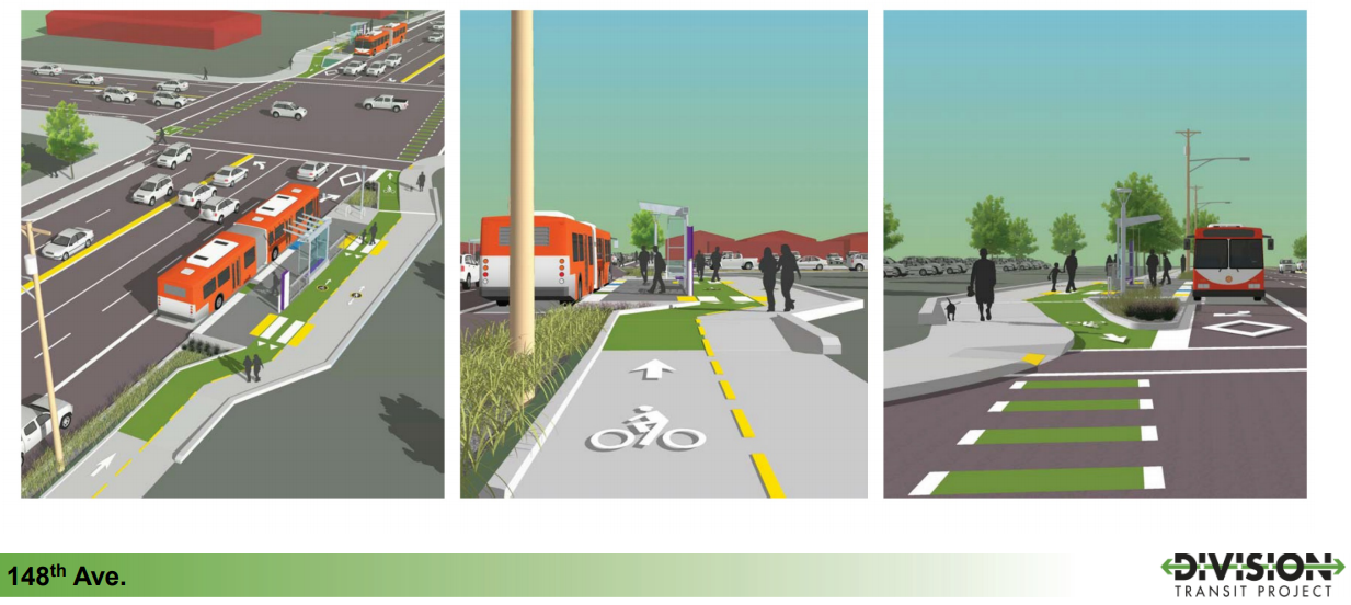
From SE 82nd Avenue to the Gresham city limits near 174th Avenue, the agency is planning to pay for a vertical barrier, mostly a series of concrete curbs, to protect the bike lanes that will have been recently widened and buffered by a separate City of Portland project. And when the Division bike lanes pass bus stops — as they would at 87th, I-205, 101st, 112th, 122nd, 130th, 135th, 143rd, 148th, 156th, 162nd, 168th and 174th — they’ll often be wrapping to the sidewalk side in order to reduce bike-bus conflicts.
This is a transit station design that’s in action from Seattle to Bogotá, but it’s relatively new to Portland: only a few Southwest Portland streetcar stops have used it so far.
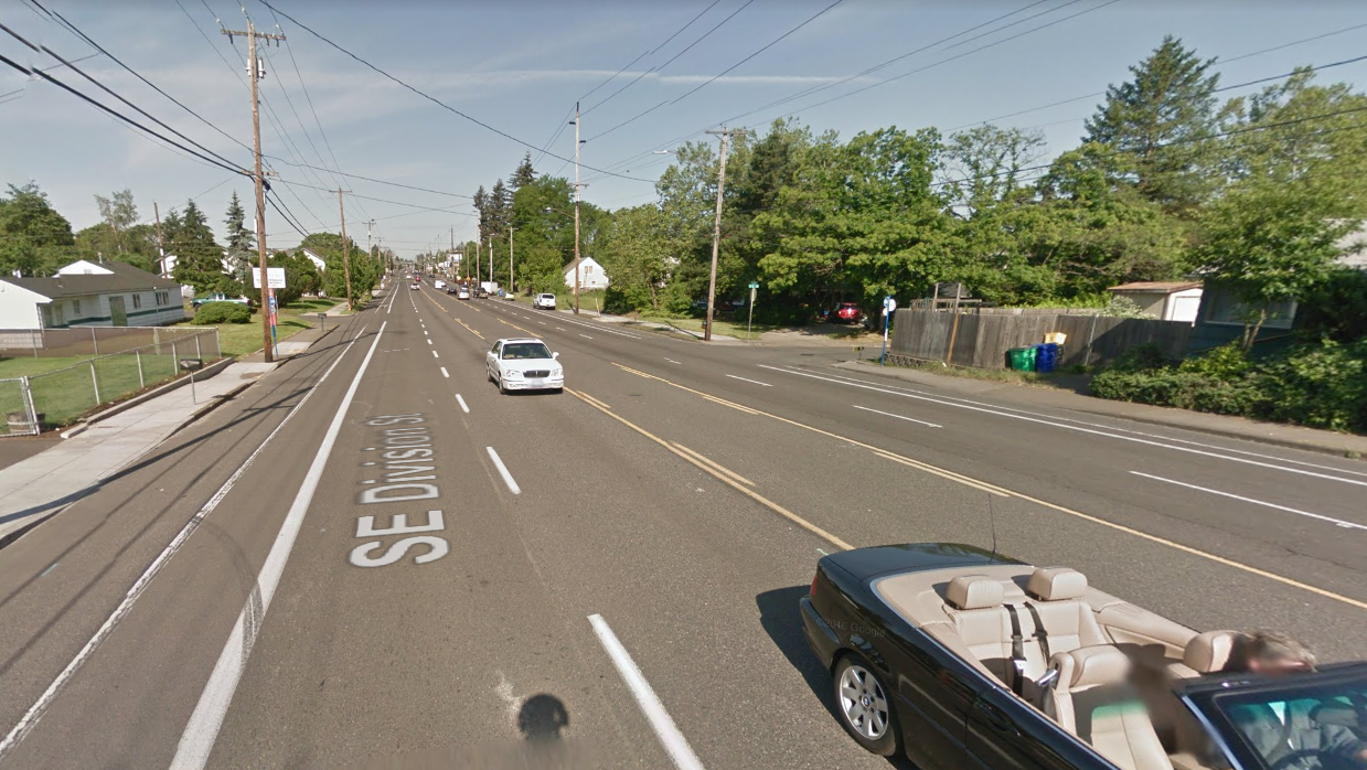
Protected bike lanes and bus boarding islands would certainly be big improvements compared to the same stretch of Division today:
Since we last shared some images from this project in June, TriMet has nearly finished a first draft of what’s known as “30 percent design” for its project. It’s made decisions such as exactly where bus stops would go and how wide lanes and sidewalks up and down the corridor would be. In the next few weeks, it’s vetting those designs with institutions around the region, including the City of Portland’s bicycle and pedestrian advisory committees.
A few newly revealed details captured in images TriMet shared recently are worth noting. None of these were on the renderings we saw in June.
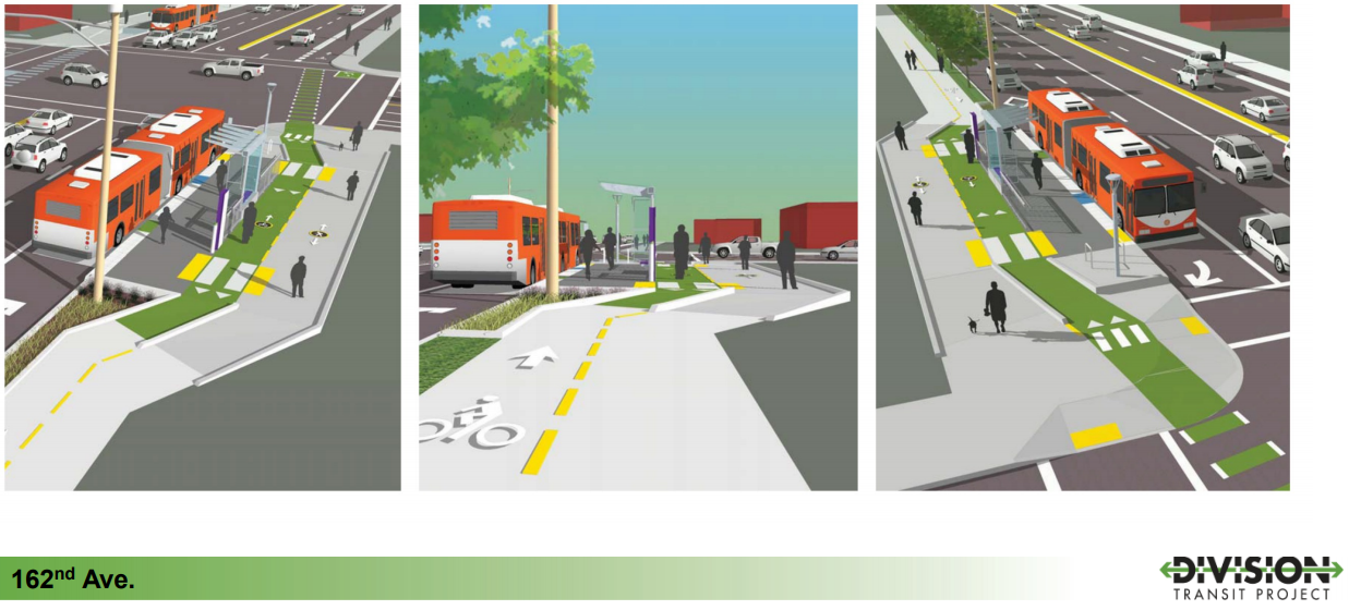
Dashed crossbikes to show bikes’ path: These are useful for helping alert people in turning cars to the possible presence of bikes, to help people confidently pedal across the street and just to raise the visibility of the bike lanes, reminding every street user that using a bike could be a good option.
Left-turn refuge boxes: One of these is easiest to spot at the top of this post, in the upper left corner of the first image. This is to help people make “Copenhagen lefts” from the bike lane, if they feel better doing so, rather than merging across multiple lanes of traffic.
Sidewalk-level uncolored bike lanes: These are more problematic. Anyone who biked or walked on Southwest Moody Avenue before 2015 knows how many people don’t notice the distinction between walking and biking lanes when they’re the same color.
Advertisement

Unprotected intersections: Both 162nd and 148th avenues have north-south bike lanes at Division. Division seems likely to become a very important east-west biking artery through Southeast Portland, and it’s possible to imagine similar protected lanes on 162nd and 148th at some point. One thing that’s not clear from these designs is why the city and TriMet haven’t chosen protected intersections that would set the bike lane crossings back from the intersection slightly. This would let people in right-turning cars make eye contact with someone on a straight-moving bike rather than prompting both parties to look over their shoulders at one another.

And here’s one thing that’s not visible:
Bike-bus priority signals: The buses pictured here are in sitting in “business access transit” lanes, basically curbside lanes that are designed for right turns and bus queue jumps. When a bus finishes loading, it would get a special traffic signal to cross the intersection first — and, TriMet project manager Michael Kiser said in an interview Tuesday, people biking and walking would get the same head start. (It’s not yet decided whether biking and walking would get a head start when a bus is not present.)
Kiser said Tuesday that though “there is buy-in in pursuing this kind of at-grade separation between bikes and peds” (in other words: a path divided into biking and walking sections), the design for how to separate biking and walking “have not been fully vetted” with the Portland Bureau of Transportation.
“We may look at a change in paving materials; maybe asphalt and concrete,” he said. “That will be informed through further discussions with PBOT.”
In general, TriMet pedestrian and bicycle planner Jeffrey Owen said Tuesday, the agency’s goal for Division is to “make it clear and delineate who’s where and when and why.”
Owen and Kiser will visit the Portland Bicycle Advisory Committee in the Lovejoy Room of City Hall, 1221 SW 4th Ave., at 6 p.m. on Oct. 17. Meetings are open to the public.
Once the agency’s current plans have been vetted and tweaked in conversation with the city and other local partners, it’ll submit them to the Federal Transit Administration in early December and hope to show up in President Trump’s budget in February, Kiser said.
(Credit for this story goes to Adam Herstein on the BikeLoudPDX listserv, a good way for ordinary Portlanders to stay up on bike advocacy opportunities in the area.)
— Michael Andersen: (503) 333-7824, @andersem on Twitter and michael@portlandafoot.org
Never miss a story. Sign-up for the daily BP Headlines email.
BikePortland needs your support.


Thanks for reading.
BikePortland has served this community with independent community journalism since 2005. We rely on subscriptions from readers like you to survive. Your financial support is vital in keeping this valuable resource alive and well.
Please subscribe today to strengthen and expand our work.
If 20 smart people post ideas here will folks at PBOT and TriMet read them?
Yes, we will.
Yes, you did. Thanks!
it’s likely they’re read them…
it’s unlikely they’ll adopt the ideas…
More trees.
East of 82nd the curb-tight 6′ sidewalks will not allow room for trees. I did ask if they could be part of the stop designs. At stops where they are obtaining right of way, a wider sidewalk could include “street trees”. But of course that would require more right of way. And trees at each end of the stops, e.g., are being avoided because of fear of the trunk blocking views of merging cyclists. Certainly people should push for trees to be included to shade the stops, at least.
Street trees are needed anyway. So many inner city streets have been rebuilt from the crust of the earth to the sky. Rebuild the death corridor that is SE Division.
And, it sure looks like there is room at the two stop designs shown, for a tree at each end of the stop, between the curb and the bike lane.
If there are any trees, as a cyclist I would prefer they be between the peds and the cyclists the trees have a tendency to completely block the motorist sight of cyclist until the last 3 foot. By then it is too late to avoid anyone. Of course the trees always block the stop signs so the motorists never see them when the leaves are on them.
That sounds good. I’d love some Oregon White Oak trees.
Next year PBOT is going to start construction on a project that will add protected bike lanes on NW 20th between Raleigh and Upshur (not the longest distance, but it’s something). Although they’re unfortunately not planning on using a different material for the bike lane than the sidewalk, they will be placing the street trees between pedestrians and cyclists, which is great.
If only there were some way to keep the leaves from blocking the stop signs, like pruning the trees up. And of course, in SOME states, they paint the stop line and the word “STOP” on the street at the intersection, at every single stop sign in the state. Oregon apparently has too little gas tax revenue to afford this.
But, yes, the trees should be on the curb side of the sidewalk, and the cyclists outside of that curb and trees. The stops shown here are a special case.
Dunno about smart but here are a few questions:
1. The paint looks nice, but with six lanes of motor vehicle traffic, and left- and right-hook threats at every corner (?), will Division still after $175m be a scary place to walk or bike?
2. What will the vehicle speed limits be, and what lane widths and other engineering to prevent speeding? The images don’t show anything #VisionZero.
3. Routing the bike lane around behind bus stops makes for slow going on a bike. Is there demand for a slow-going bike route here, or is this mostly a get-across-town route for East Portlanders who need to go pretty far? Have Seattle and Bogota tried this design in lower density, less-central areas similar to East Portland?
4. The images don’t show much beyond the bus stops, but it looks like a “standard” bike lane on the other side of the street. If it will have a curb instead of just a painted stripe, will it get swept or just accumulate leaves and debris?
5. Even if there’s a bike lane on the other side, if there’s something resembling a separated multi-use path on one side won’t that understandably attract pretty much everyone, including two-way bikes? Can the separated path handle that foreseeable use?
I think these drawings show the configuration at stops only. AFAIK, the bike facility will revert to a protected bike lane for the rest of the street, with a curb separation, where it is possible between driveways. The drawings unfortunately do not show the transition from these protected street-level lanes, to the sidewalk-level lanes and sidewalks.
Good thoughts Scott; I appreciate you taking the time and energy to share. My initial personal thoughts are below, and these can evolve and improve through the process as we all learn and share together between agencies, advocates and the design teams working on this project. 1) I think these streetscape improvements when viewed all together really will improve the feel of biking and walking along Division, with more space/buffered/protected bikeways for long linear stretches, and careful design attention around bus stations, plus improved sidewalks, crossings, etc. 2) We’ll check into speed limits and lane widths with PBOT’s help to clarify going forward. Protected/buffered bikeways are directly linked to vision zero, as are improved crossings, ADA ramps, etc. So I think quite a bit of the project elements support vision zero. TriMet is a partner (along with a large coalition of partners) in City of Portland Vision Zero efforts. 3) Good question; let’s carry this forward in discussions. I think that as a whole project, most of the bikeway will be seen as both a more protected place to ride a bike (to help entice more of the population to consider riding a bike), and generally speaking, bike movements kind of slow down a touch around bus stations/stops and intersections in general, and as there is friction along the roadway, so I don’t personally see this as a drastic slowdown of the bikeway, but yes to a slight slowdown around bus stations, where people on bikes can expect to see transit riders crossing the bikeway to reach the platforms and boarding spaces from the sidewalks. 4) Both sides of the street will have a similar bikeway treatment (eastbound and westbound) with buffer/protection as much as possible, with likely a mix of bikeway conditions as the immediate conditions warrant. Both design and maintenance are very good flags to carry forward as we progress through the project for both TriMet and PBOT. 5) Both sides of the roadway will have similar bikeway designs, both designed as one-way bikeways and two-way sidewalks, so we suspect this will be evident to users in the built project.
Regarding Seattle and bus islands: the first street in Seattle with bus islands was Dexter, which, though it is close to downtown, is mostly a through-route because of topology (it’s in a narrow corridor between a lake and a highway along a steep hillside). It’s long drawn a rather fast-paced and weirdly aggressive commuter crowd, and some of these people ride around the islands on the traffic side, but most slow down and stay in the bike lane.
Farther from downtown, Seattle has similar bus stop arrangements on:
– Roosevelt, between NE 65th and the U Bridge. This will be extended to the Northgate area eventually. That’s not “less central” the way outer Division is, though… I might compare it to the arterial part of Broadway (this part of Roosevelt is a multi-lane inbound one-way and changes to a two-way arterial north of 75th before the main arterial is carried away diagonally by Pinehurst Way). Bus islands will be extended both south of the U Bridge and north of 65th in the next several years.
– Greenwood Ave, at N 92nd and 97th. I think these are reasonably comparable to the area near outer Division (west of I-5 there tends to be a drop-off in urban infrastructure past the old city limit, mostly on 85th, and another past Holman/105th). These island stops were part of a more modest street project; Greenwood’s status as a bike route is diminished by the lack of bike lanes (or even sidewalks) north of 105th (where there are also more car lanes) and a parallel Greenway route a few blocks to the east that connects more directly to the regional Interurban Trail.
Thanks very much for sharing these examples. I’ve ridden the Dexter stretch, but not the other ones. We’ll take a closer look at these.
When I was in London last year I biked along the newly built Cycle Superhighway 2, from the Olympic Stadium to Aldgate, a distance of about 3 miles (a little less than I-205 to 174th Ave). Although not a low density area, it’s definitely a “get-across-town” kind of a route. They have floating bus islands along the whole route, as can be seen in Google Maps (https://goo.gl/maps/ty6H2UdQ9et).
While you do need to slow down a bit at the stops to be cautious of pedestrians, it’s not a problem unless you’re trying to set a segment record on Strava or something. I definitely preferred it to the bus-bike leap frogging situation that occurs on streets where the bike lane is in between the bus stop and the bus travel lane.
Regarding the “vertical barrier” to protect bike lanes. Apparently there are so many driveways to access that there may be more gaps than barriers.
I am not convinced that Tri-Met is the best agency to be designing on-road bike facilities. Their vision for cycle infrastructure is only surface-deep and seems to treat bikes as glorified pedestrians, and clearly give them a back seat to bus interests. I understand that Tri-met gets way more money than their mode share, relative to cycling, and it’s not a great idea to look the proverbial gift-horse in the mouth as Tri-met brings in the big grant money, but I would like to see their designs get more bike refined and deeper effort be made to accommodate the specific needs of cyclists on the roads. It’s good to see the Tri-Met folks here, listening. The bike infra along the Orange line leaves a lot to be desired, and when you look at the dollars spent and the mode-shares involved, bikes need to be getting a bit larger slice of the investment dollars.
If you don’t trust TriMet but trust some other agency more (PBOT for example) then right now is your chance to motivate PBOT to ask for stuff. This is the city’s moment of maximum leverage over TriMet, as the agency is rushing to submit its plans to the feds.
Personally, I tend to think TriMet is better than most transit agencies (where staffers often don’t even have surface-level understandings of biking), but I agree that some of the Orange Line bike infrastructure was a disappointment. That’s why I wanted to do this post!
I can definitely appreciate your skepticism, and I don’t take offense, but – please do stay engaged, help us to continually improve, and share your thoughts and ideas for these projects and more. Trade-offs often dominate most all transportation projects. TriMet staff, managers, directors, across many departments in our agency, cycle to work, cycle for errands, and we know that we are part of the solution to continual improvements in mobility in this region. So please do continue to contribute, help, and offer your thoughts and ideas. We’re listening, and paying attention.
It’s incredibly refreshing and awesome to see this kind of openness. Thank you!
(And this is coming from someone who silently fumes biking the Orange Line bike lanes every day)
Thank you so much! Yes, I am trying to be engaged on this, especially in my local areas.
The bike facilities through the transit stops look a bit on the narrow side for such an obvious conflict zone (peds just getting off the bus, people on bikes dealing with peds crossing both ways, changing direction several times, curbs appearing in the middle of those direction changes, an approaching intersection,…busy times).
Also, crossbike markings have no legal standing; they’re just bikey art. What is the right of way situation at the intersection? If the transition to an off-street bike lane is legally considered to be a bike lane and not a separate bike path, then when someone is right-hooked at the intersection the motorist will be at fault. If it is considered to be a side path, then the people on bikes lose all right of way as they negotiate the intersection. Hopefully there will even be lit signs up instructing motorists to yield to cyclists. (I really hate bike facilities to the right of right-turning traffic.)
Overall, it looks more than a little problematic and, for most riders, will present the sort of challenges that discourage riding.
Some designers actually look to narrow the bikeway facility a touch on purpose in a situation such as passing behind a transit platform, to encourage single file riding through that section, to prevent one bike passing another in this particular small space. The thought is to help clarify and give line of sight to favor a transit rider who is crossing the bikeway. As pointed out in the story and your comment, this is something we need to continue to hone in on, talk to peer cities who have more of these treatments in place, and try to ensure we get it right. One big tradeoff to consider with boarding islands is that we are now asking/requiring a transit patron to have to cross a travel lane (of sorts – meaning the bike lane) in order to get to the transit platform from the sidewalk. That’s actually quite a downside for someone of limited mobility, limited sight, etc. That could be considered quite a large “ask” when compared to the total comfort of a transit patron staying on the sidewalk and having the transit vehicle come right up to the curb of the sidewalk to get them. By design of the transit platform, pedestrians will be channeled to the two crossing locations from the platform space to the sidewalk, and will not be free-flowing across the bikeway for the entire length, due to furnishings like the shelter, bench, signage, possible railing, etc. The markings proposed are similar to how the current SW Moody sections work, and by most all accounts, those are working well because they clearly delineate where the crossings between bikes and pedestrians happen. Overall, I think these designs seem to be working well in other cities, and I believe they are part of the solution in our world of multi-modal corridors. I appreciate you raising the crossbike question – we’ll need to investigate and sharpen our pencils with PBOT to make sure everyone knows the expectations for these crossings. The intent is to make it more clear with green paint where these points of conflict might occur, which helps bikes follow the green paint, and helps to signal auto and truck drivers that they are crossing over a bikeway. There also may be signal timing opportunities to try and separate the bike movement from a turning car moving, where appropriate. We’ll need to keep an eye on this and help clarify moving forward with signal experts.
Why not make this a Dutch-style protected intersection? There’s plenty of room, it would take just a touch of concrete, would slow cars down on turns, increase visibility for everyone, and feel infinitely safer for the average person. http://3.bp.blogspot.com/-W77gPF3CHTo/UvDnjNzWzcI/AAAAAAAARCE/vB1UiGvirJY/s1600/Dutch-intersection-for-Chch.jpg
This was my first question. The most important safety design component is absent. A lot of people are going to be injured/killed via right hooks given this design. What are the potential costs of adding one or two protected intersections at high traffic intersections?
I think the safety of bikes/buses and peds could be improved if the bus stop were moved an additional 50-75 feet in from the intersection. This would give much greater visibility and longer reaction times to the merge conflict between bikes and people driving turnign right. It also lets the bike deal with any potential conflicts at the bus stop and then deal with the merge with the right turn lane. If I am biking through here as it is drawn and there is a bus at the stop loading passengers, my first priority is getting past the bus and into the shared turn lane/bike lane safely. That means getting past the bus far enough to be visible to people driving along side the bus. If the bus stop were pulled in from the corner, I can deal with bus stop and then the merge separately instead one continuous cluster
As a bike lawyer, I disagree that “crossbike markings have no legal standing.” Certainly, they’re new, people need to get used to them, and some updates to the ORS and/or MUTCD may be in order. However, they provide a lot of clarity for where people on bikes are expected to go, and highlight conflict zones where drivers should be especially alert. I have not heard of PPB ticketing people for confusion about who gets to go first where crossbikes are used at uncontrolled intersections. To me, crash risk and fault are the key issues. I see one driver stop and the second lane not stop routinely at regular crosswalks. Rampant noncompliance is probably more dangerous than confusion. Ultimately, it is jurors who apportion fault in crashes. I expect crossbikes in most cases will make it harder for defense lawyers hired by insurance companies to argue that the person driving a motor vehicle was reasonable in not expecting or seeing a person on a bike. In a serious crash case, that’s the “legal standing” that matters. As a rider, I am thankful for infrastructure that increases everyone’s awareness of my presence and right to the road. (Small beef: As a person who also walks, I wish PBOT wouldn’t paint stop lines for crossbikes that cause drivers and cyclists to stop in or after the crosswalk, e.g., NW Johnson EB at 23rd.)
Quick question: do the planners at TriMet know how bikes work?
Like buses, they doesn’t move in sharp angles, but in flowing lines. A cyclist traveling the length of this project will be forced to make many quick steering changes which are not safe or efficient. Biking is all about efficiency and momentum. The same goes for peds, they take the shortest path. Notice they force peds wishing to enter the end of the platform jog out of direction to accommodate the bikeway width. Never going to happen. This will lead to unnecessary bike/ped conflict. Seems to display a baseline ignorance of how things work in the real world, not paper. Tillicum is full of this naive sketchup design.
Also, as anyone who rides knows, concrete is a horrible surface for road bikes, tends to fracture at edges when used as strips bisected by heavy traffic.
One last suggestion: They need some minimalist cable fencing or swag chains where those curbs separate bike lanes from traffic similar to the OHSU stop on the OL. This discourages mid-block peds. Especially critical near stations.
A softer approach to providing input would really be appreciated, some of us designers ride bikes and advocate for the mode. As an example how would you feel if I told you this as a response in a meeting?
‘Quick question: does the public even know how federal standards work?
Anyone who designs ADA ramps knows that you don’t get enough grade control out of asphalt. And, if you were to build a ramp or landing section which is subject to ADA requirements out of asphalt then you likely would have to rip it out after constructing it and redesign it in concrete causing construction delays and costing the taxpayer money. If you decide you don’t like federal standards and ignore them then you either don’t get funding from FTA or get sued down the line and can’t provide needed improvements in the future because you are fixing existing infrastructure to meet standards.’
Designers must compromise to meet the requirements of a lot of conflicting goals, there is also a lot of paper that governs what we can build. Compromise will be key to cyclists gaining their own protected spaces as well, connections aren’t always going to be convenient.
AE: Thanks for fighting the good fight but It’s precisely this sort of forrest-through-the-trees thinking (attention to minutiae at the expense of a larger vision) which gives us the mediocracy currently flowing unchecked out of Portland and US transit design in general.
Consensus is one thing but compromise enough and you end up something everyone hates. Remember the CRC? $110m in planning and ten years of compromise on a plan so muddled and bloated no one could get behind it, save special interests.
The last major transportation project completed in the region was the Orange, which from a ridership #’s and on-the-ground experience can be safely called an abject failure by all but those with a stake in the fire. Sorry if that hurts some transpo designers’ feelings but it is the truth. We need to rise to the challenge not pat ourselves on the back for how many NHTSA, FTA, ADA, USGBC, DOT boxes are checked. Because the end it’s voters which will have to be sold on the cost/benefit of new projects. Not just alphabet soup bureaucrats.
“connections aren’t always going to be convenient”
While I agree with most of your point, the above quote is exactly what discourages cycling or any other mode of transport. If connections are difficult or confusing or even just plain inconvenient, most people are going to just choose to drive. Because it’s easier. Hard-core cyclists or pedestrians, or public transit users (or those who are forced to used those methods for economic reasons) will make do. Everyone else probably won’t.
We do know how bikes work. We ride them, and we like them. There are always trade-offs, and unfortunately not every project can provide a perfect, uninterrupted trail like experience from door to door. The truth is that the public right of way is a bit messy, and there is a lot involved – utilities, various demands and standards from regulations, policies, and politics. We do value your comments, and that’s one of many reasons why we are sharing design concepts, and take feedback from riders, agency partners, advocates, experts, designers, users, etc. These concepts are still in draft form, surfaces and treatments are still being evaluated with all of the project partners, including of course PBOT. So, we are excited to get feedback, and let’s keep improving the project together.
I for one am very excited to see these draft designs but I think folks have largely caught on that the process is rigged and will end up a cluster of compromise and waste. As a past participant, I know I have. Good luck to TM and best wishes, but no amount of community input can compensate for a lack of leadership and vision especially with all the competing interests being catered to here.
Ask a business owner what they want: free parking, driveways, 2,000 vehicles an hour.
Ask a ped: signalized zebra crossings every 200′.
Ask a commuter: clean busses every 10 min.
Ask a driver: 45mph and no lights.
Conflicts are inherent. Pretending like everyone is going to be happy at the end is a fool’s-errand.
1) Need to smooth out the sharp angles of the bike/ped transition areas..
2) git rid of those little curbs separating the bike/ped areas in these transition areas..all they will do it trip people and bikes..
3) get rid of all the marking for bike/ped crossing areas, they will just confuse people and gives people a false sense of security that bike/ped can cross this area without looking.
It’s precisely this sort of forrest-through-the-trees thinking (attention to minutiae at the expense of a larger vision) which gives us the mediocracy currently flowing unchecked out of Portland and US transit design in general.
Consensus is one thing but compromise enough and you end up something everyone hates. Remember the CRC? $110m in planning and ten years of compromise on a plan so muddled and bloated no one could get behind it, save special interests.
The last major transportation project completed in the region was the Orange, which from a ridership #’s and on-the-ground experience can be safely called an abject failure by all but those with a stake in the fire. Sorry if that hurts some transpo designers’ feelings but it is the truth. We need to rise to the challenge not pat ourselves on the back for how many NHTSA, FTA, ADA, USGBC, DOT boxes are checked. Because the end it’s voters which will have to be sold on the cost/benefit of new projects. Not just alphabet soup bureaucrats.
I agree with Michael that the unprotected intersections as the biggest opportunity for improvement to this project. I’m very concerned that the current design leaves people on bikes vulnerable to right hooks as they enter an intersection with a bus stop.
Imagine you are on a bike approaching an intersection. The bus stop, the people standing on the island, and perhaps the bus itself will all be preventing right-turning drivers from seeing you. Impatient ones are likely to veer in front of the bus to squeeze in their turn as the bus loads. They will probably try to execute their turn directly from the middle lane (rather than merging into the bus lane), increasing their effective turning radius making it still less likely that they will see a bike two lanes over. We should expect and design for exactly this kind of behavior, because you see it all the time today on Outer Division.
That said, I don’t see how the version of protected intersections pictured could work without a lane of parking and/or a turning lane that ends at intersections. I wonder if there is a version that could work by forcing right-turning drivers to properly merge into the bus lane (waiting, if necessary, behind the bus to finish loading). Optimally, this could be a coupled with a signal that forces right-turning drivers to stop before turning. That way right-turn drivers would merge and stop either way, making right-turn conflicts much less likely.
Also, I want to voice some mild disagreement with others here about the bike lane veering behind the bus loading zone. I don’t see an issue with this design, assuming we solve the visibility problems mentioned above. To me, the number one priority should be the safety of vulnerable road users. A less important (but still important) priority is to allow people biking *at a modest pace* to minimize stopping and slowing down.
Assuming they feel confident crossing the intersection (the big if here), I don’t think most people (the ones going ~12mph) are going to need to slow down significantly to navigate these bus stops. And if you are going significantly faster than that, you absolutely should be slowing down when you enter a mixing zone with pedestrians and wheelchair users crossing your path.
I think the issue is who has right-of-way/priority in a marked cycle lane because in the US there are relatively few of them designed to go around buses like what’s proposed. In the Netherlands, pedestrians yield to cyclists on a cycle path. In most other countries (likely including the US) a cyclist must yield to a pedestrian in a cycle path.
Not that I expect many conflicts because we’re talking about a pedestrian crossing a small-width travel lane, but it can be frustrating as a cyclist to be stopping every other bus stop to let someone cross the cycle path. (It’s around the concept of the Idaho stop; cycling from a stop is much more energy-intensive than when a bike is rolling.)
Yep, it definitely isn’t optimal to have to stop for someone to cross. I don’t see a way around it though. Installing a bunch of pedestrian signals would be expensive and people are almost certainly going to ignore them. And, given the mode hierarchy, shouldn’t folks on foot have the priority here?
So, it’s a pain to stop but I’m guessing you won’t have to very often. Unburdened, able-bodied folks will be able to cross the bike lane in a split-second, making a quick dash in between passing cyclists (again, assuming they are traveling at a reasonable speed for a mixing zone). Others may take a bit longer and force you to stop, but chances are it won’t happen on most of the intersections you pass on a given ride. I guess the worst case scenario is that you are biking slightly ahead of a bus and the whole time people are rushing over to catch it. Still, even this scenario is certainly safer and probably faster than criss-crossing lanes with the bus constantly!
Appreciate the link – Any chance you might know of examples where the two streets crossing are larger multi-lanes in each direction with bus stops?
Wouldn’t Division and 122nd meet that description? Currently the bike lanes on either street drop off a block from the intersection.
Oh I see, you meant a Dutch-style design FOR such large intersections. Perhaps Nick Falbo has seen such an intersection (or designed one?)
So… I know we’re too late in the project to go back and change this, but I’m curious – was a dedicated bus lane on Hawthorne ever considered as a possibility? Crawling down inner Division isn’t my idea of fun, efficient, or giving priority to transit.
I guess my question is – where did this stop? Was it not even considered by TriMet traffic engineers? (“Of course, there are tons of intersections to deal with, and it’ll have too much impact on car LOS, we don’t even need to think about that”)
Was it considered but eliminated by TriMet alone due to presumed political impossibility?
Was it considered by eliminated by PBOT due to one of the above?
Was it considered, some outreach done, and eliminated due to business owners unanimously saying it would be horrible?
Etc.
Curious advocates want to know where to focus efforts!
I think the dedicated bus line for this route belongs on Powell!
Well, yes, but I am assuming ODOT as an immovable object for the time being 🙂
yes, it always has…
I’d like to propose a concept of “Bus Rapid Transit Level of Service” or BRTLoSLOL.
A – Taking the bus from bus stop A to bus stop B is more than 60% faster than driving one’s own polluting, space-hogging, dangerous motor vehicle from bus stop A to bus stop B.
B – 40%-60% faster
C – 25%-40% faster
D – 1-25% faster
F – Taking the bus from bus stop A to bus stop B is no faster than driving one’s own polluting, space-hogging, dangerous motor vehicle.
Jeff:
It looks like a (large?) tree could be planted in the triangular grassy space on the upstream end of the 148th Ave stop shown here. Can that be added to the plans? Yes I notice there’s a pole further upstream. Perhaps it has a street light on it. I’d hate to see that one streetlight used as a reason to not have a tree. If we’re serious about reducing heat islands, we need rethink our street lighting, so that some lights are below the tree canopy (for pedestrians), and some are further out over the street, beyond the canopy (for cars).
The 162nd stop has a similar triangular space, but a (existing?) pole is right in the middle of it. Can that pole be moved, so that the patrons there can wait in the shade as well?
Thanks Doug; we’ll take a closer look and see if we can get an answer very soon. I like trees as well, but vegetation typically gets smallish near station platform areas to preserve open lines of sight, so that might be a tough one.
I hope you can find a way to get trees. It seems there’s no sightlines to block at the upstream end, as vision is blocked by the shelter anyway. And, a tree blocks sight less than a shrub. Trees should be pruned up (to 8′, e.g.) so you can see under them. The trunk itself is no wider than a power pole, and people seem to see around those poles.
I see business as usual for motor vehicles here… that means the bus will still be stuck in traffic trying to get to the stops before they get any priority green lights… and I see a lot of buses illegally passing on the right in the parking area as they already do throughout the city…
and of course once you get west of 82nd you have the same gridlock as always and all the time you saved on the east end is wasted…
guess we’ll wait and see but I’m extremely skeptical that this will help any transportation mode…
I think the safety of bikes/buses and peds could be improved if the bus stop were moved an additional 50-75 feet in from the intersection. This would give much greater visibility and longer reaction times to the merge conflict between bikes and people driving turnign right. It also lets the bike deal with any potential conflicts at the bus stop and then deal with the merge with the right turn lane. If I am biking through here as it is drawn and there is a bus at the stop loading passengers, my first priority is getting past the bus and into the shared turn lane/bike lane safely. That means getting past the bus far enough to be visible to people driving along side the bus. If the bus stop were pulled in from the corner, I can deal with bus stop and then the merge separately instead one continuous cluster
One of my favorite games, when I see an article about infrastructure improvement, is to come to the comments and see how long it takes for people to start dumping all over it. Never fails to disappoint! I think this bus stop/sidewalk/cycling improvement looks great.
Oh, please. Does every comment that references how disappointing this project is in the bigger picture have to start with “I’m sure the project designers are doing a wonderful job given the constraints imposed on them by politics and their higher-ups? Congratulations on moving the ball half a yard forward! I’m sure we’ll get a touchdown by 2200!” I really want the low-level staff who is seriously working for progressive change at TriMet and PBOT know that we greatly appreciate their work. But expecting every comment to include that kind of complimentary disclaimer is just not necessary or realistic. We’re all adults here. Doing a Portland compliment/criticism/compliment sandwich shouldn’t be the price of entry to the BikePortland comment section.
Portland is proposing a Transportation System Plan that includes an increase of the transit mode share from 13% now to 25% in 2035. Does anyone really think that this project puts us on the path to that? I think that even if a project like this were replicated for every bus line in Portland, it wouldn’t get us anywhere near 25%. And, this project is going to take, what, 10 years start to finish, and there are no other transit projects in the works in Portland currently? The fact is that this is a sad half-measure of a project which will only increase the speed of transit incrementally, and will only make a street that is currently ridiculously uncomfortable and somewhat unsafe to navigate outside of a car slightly better.
Yes, it will be somewhat better than what was there before. But if our politicians say our goal is X, then their agencies do a tenth of what is necessary to be on the path to achieve X, do you really want the public to go ahead and say, “Yay, we got a tenth of what should have been our goal for this project! That’s way better than nothing! I am so thrilled about this!”
This project has been a challenge from the start, and countless hours of volunteer time has been contributed in the process. Thanks to all who have spent their evenings at meetings, or reviewing plans. The fact is, if Tri-Met applies for federal funding for this project and doesn’t secure the funding, it will be another great idea down the drain, and yet another study in East Portland that, so far, hasn’t produced much concrete on the ground. Put another way, business as usual 🙁
Why is the bike lane located on the bus platform side of the shared bike lane/ped lane section? This layout means that pedestrians step out from the platform directly into the path of bicyclists. And the street furniture on the platform reduces the line-of-sight for both pedestrians and bicyclists. I recognize that the furniture is transparent and pedestrians are channeled to two marked bike lane crossings. It still seems like the bike lane is in the wrong place.
The alternative is to locate the bicycle lane on the far side of the space, away from the platform. Then the bicycle lane must cross the sidewalk at each end of the platform. That also will induce bike/ped conflict, but there’s more space to move those crossings away from the busy platform, and there should be more visibility for both cyclists and walkers.
Either way, there will be mixing of pedestrians and cyclists. I think it’s better to move the bike lane as far away from the primary pedestrian space as possible.
—————
I agree with other comments that the bike lane across the intersection invites problems with right-turning drivers. What is being done to mitigate that?
The sidewalk is furthest away from the street, at the edge of the private property, so pedestrians can walk into the buildings that are nearby at 162nd, and that may be built abutting the sidewalk at 148th (presuming redevelopment happens on the giant parking lot). Sidewalks are always furthest from the street to access adjacent land uses.
That makes sense where there are abutting buildings. Where those don’t exist, why not route the bike lane to the outside and then repaint when the land is developed? Or encourage the developers to provide pedestrian space on their side of the route.
Another idea: this photo from BikePortland shows an Amsterdam floating bus island with a bike lane inboard of a pedestrian sidewalk: https://www.flickr.com/photos/bikeportland/36891113564/in/dateposted-public/ I think the curbs that outline the bike lane will help to reduce bike-pedestrian conflicts. The curbs will remind walkers to look both ways as they cross the bike lane.
Mark:
The picture of Amsterdam shows a floating bus stop, which is not a sidewalk, but only a bus stop, and then the bike lane, and on the far right, the regular sidewalk, which is against the buildings. Routing the bike lane at the back of the walk (nearer the property line), is a bad idea from all sorts of urban design angles. But the basic issue is the sidewalk, and bike lane, should both be in the public right of way, and the sidewalk needs to be at the outside. Putting the sidewalk near the property line will discourage new buildings from being located there, or at least opening their doors there, which is exactly what we want to encourage at transit stops. Also, I think the Trimet plans include paving and/or elevation changes to differentiate bike vs ped, so they couldn’t easily be switched.
Mark: Okay I now see you’re saying “switch them, OR put curbs”. I misread that. I guess the difference from Trimet’s design is how high the curbs are.
As far as pedestrians being reminded to look both ways: As a meeting attendee pointed out: The city’s Transportation Hierarchy puts pedestrians first, and then bicyclists. So, logically, the ped path from sidewalk to floating bus stop, should be level. Cyclists should have to ramp up to the ped crossing and then ramp back down. This “bump” at the point of crossing should serve to remind cyclists to watch out for, and stop for, pedestrians, not the other way around. Some of Trimet’s drawings seemed to show that, but now they seem to have gone to completely level.