With the opening of the Tilikum Crossing Bridge now less than two months away, TriMet has decided to change the way bicycle riders and walkers access it. They plan to switch the lane assignments on the SW Moody cycletrack and add more striping to make it clear where people are supposed to bike and walk.
In partnership with the Bureau of Transportation, TriMet has announced several “refinements” to SW Moody in hopes of encouraging safer and more efficient biking and walking and better access to the new bridge. In a press statement released tonight at the monthly meeting of the Bicycle Advisory Committee, TriMet says the changes come after weeks of monitoring the cycletrack, sidewalk and transit operations around the SW Moody MAX station.
Advertisement
Here’s more from that statement about the upcoming changes (emphases mine):
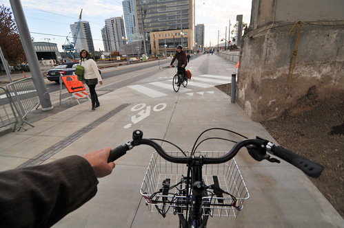
On the west side of SW Moody Ave, the lanes of the cycletrack and sidewalk will be permanently repositioned between SW Sheridan and the Ross Island Bridge area so that bike and pedestrian movement is consistent along this entire north-south route. The sidewalk will be against the west railing, the southbound cycletrack will be in the middle, and the northbound cycletrack will be closest to the curb. Striping will be added to more clearly delineate the space for each mode. Guidance railing will be added around the southbound Portland Streetcar stop, and some signals will be adjusted.
This project will start next week and will result in the complete closure of the cycletrack between Sheridan and the Ross Island Bridge from July 20th to August 7th. From July 23-29, the closure will extend north to SW River Parkway. TriMet says the detour will be adequately signed and people should expect to use sidewalks and bike lanes until the project is completed.
Stay tuned for updates and a first look at the changes once they’ve been implemented.
For more information, download a PDF
of the announcement.
UPDATE, 7/15 at 4:00pm: TriMet has just released the official announcement about these changes and the upcoming detours.


Thanks for reading.
BikePortland has served this community with independent community journalism since 2005. We rely on subscriptions from readers like you to survive. Your financial support is vital in keeping this valuable resource alive and well.
Please subscribe today to strengthen and expand our work.
Great. It never made any sense for it to switch configurations. Also, having the trees divide the cycle track from the sidewalk will make a lot more intuitive sense than the current configuration where the trees are between the two directions of the cycle track.
On a different note, PBOT is now starting on design for SW Bond through the Zidell / OHSU properties. Does anyone know if they intend to include bike lanes, or what it will look like?
Don’t they have to include bicycle facilities per the Oregon bicycle bill?
I’m not familiar with what that law requires, but if it really required bicycle facilities on every newly built street then there would be bikes lanes on every street in the Pearl north of Hoyt. There aren’t.
“Bicycle facilities” doesn’t necessarily mean much. A shared lane is a legitimate bicycle facility.
Perhaps sharrows are technically considered “bicycle facilities”, but they shouldn’t be. As a friend of mine put it, “Sharrows are literally pictures of people on bikes, repeatedly being run over by automobiles.”
Certainly don’t put sharrows in bad places. 🙂
Not every street needs a bike lane or cycle track in order to be a safe, effective, world-class street where people of all-ages and abilities are welcome.
This is the vision of our city’s neighborhood greenways – some of which are more successful at it than others.
“sense”
requiring people biking to switch of lanes near a heavily used pedestrian area is unsafe. the blind entry into the southbound bike lane at sheridan is also unsafe. and finally, requiring users to negotiate trees and recessed pavement to pass a slower traffic on the southbound route is unsafe.
these things were criticized on bike portland from day 1. i personally believe that bike infrastructure planners and engineers should be required to read (and take seriously) bike portland comments.
Perhaps it is the speed at which cyclists are riding in congested locations, or inattentiveness that is unsafe. Designers can only make so many concessions for bad riders.
Cyclists?! No, it’s everybody! From pedestrians walking in groups, or walking in one of the bike lanes with their head up their phone. Or, the speeding cars down Moody threatening you with their distracted driving at each crosswalk.
It’s not one group, by far.
Please note the section I have highlighted:
§ 814.420¹
Failure to use bicycle lane or path
• exceptions
• penalty
(1) Except as provided in subsections (2) and (3) of this section, a person commits the offense of failure to use a bicycle lane or path if the person operates a bicycle on any portion of a roadway that is not a bicycle lane or bicycle path when a bicycle lane or bicycle path is adjacent to or near the roadway.
(2) A person is not required to comply with this section unless the state or local authority with jurisdiction over the roadway finds, after public hearing, that the bicycle lane or bicycle path is suitable for safe bicycle use at reasonable rates of speed.
(3) A person is not in violation of the offense under this section if the person is able to safely move out of the bicycle lane or path for the purpose of:
(a) Overtaking and passing another bicycle, a vehicle or a pedestrian that is in the bicycle lane or path and passage cannot safely be made in the lane or path.
(b) Preparing to execute a left turn at an intersection or into a private road or driveway.
(c) Avoiding debris or other hazardous conditions.
(d) Preparing to execute a right turn where a right turn is authorized.
(e) Continuing straight at an intersection where the bicycle lane or path is to the right of a lane from which a motor vehicle must turn right.
(4) The offense described in this section, failure to use a bicycle lane or path, is a Class D traffic violation. [1983 c.338 §700; 1985 c.16 §338; 2005 c.316 §3]
My definition of “reasonable” is “The speed limit of the adjacent street, or 40 mph, whichever is lower”. I wonder what “reasonable” works out to be in real life?
20 mph is a number I hear a lot.
Sure, but I say if 30 mph is “reasonable” for neighboring car traffic, then it should be “reasonsble” for me, too on my bike—especially on a downhill. What make me bristle is the idea that on some roadway, auto traffic is allowed to go a “reasonable” 30-35, but bike traffic is artificially required to go no more than 10-15, ‘cuz bikes. I use a particular stretch of bike lane on my way home most days where I go downhill at 40, which happens to be the speed limit for the road.
Someplace like Moody, where bikes have been essentially excluded from the roadway by an unfortunate arrangement of streetcar tracks, it would chafe at me every day to see cars driving straight on down the road at 25, while I was meandering around at 10 between pedestrians and waiting to make gratuitous street crossings.
“Geller testified (and the judge agreed) that the public participation in drafting the 1996 Bicycle Master Plan was adequate to qualify as a hearing that covers the entire bike network without requiring hearings for each segment.” — http://bikeportland.org/2006/11/07/expert-witness-backfires-on-da-in-bike-lane-case-2497
It’s ridiculous to claim that the implementation cannot be flawed because nobody complained about the plan decades ago. Besides 3ft lanes probably not being in the plan, many unusable segments of bike lane are unusable because of context.
are you really arguing that smacking into a pedestrian at 10 mph at the blind entrance to the cycle track is safe? even a low-speed collision can result in either the cyclist or pedestrian smashing their skull into pavement.
This is encouraging. I hope they’ll consider some refinements to the east side as well. There are a lot of small, relatively easy to fix issues that add up to a riding experience that is less consistent, clear and safe than it could be.
Agreed. The new shared path on the east side between the bridge and Clinton is confusing. Hoping for some improvements to signaling and signage there.
It gets even worse as you go from Gideon on to the shared sidewalk/path. And the whole thing ends without warning at McLoughlin.
Yes, they really missed a great opportunity to continue bike and ped infrastructure parallel to the light rail farther south than where it ends at McLoughlin.
I believe there will actually be a path continuing south to Harold. They’ve started construction on it and k believe it will be done in Setember. I have a hard time imaging many people will use it, but I think the plan is to someday continue it all the way south to Milwaukee.
Regardless, neither this path nor the existing endpoint will do a good job of connecting to bike infrastructure in Sellwood-Westmoreland.
You’re right William. There will be a path along McLoughlin that will run to Harold. Using the signal to cross McLoughlin people bicycling will be able to connect to the 19th Avenue neighborhood greenway that will run south to the Springwater Corridor (including a HAWK signal at Tacoma). We would have liked to have a pathway along McLoughlin that extended all the way to the Springwater (it was added to the Portland Bicycle Plan for 2030) but it wasn’t in the cards with this project…
This path seems great as a first phase of a continuous path along McLoughlin to the Springwater. Until then it’s difficult to imagine someone cycling north on SE 19th to then cycle east for four blocks out of direction travel, including having to cross McLoughlin, instead of just cutting over to SE 17th.
I agree, but I’m glad there are options. Cycling north on 17th isn’t bad if you are comfortable taking the lane (south is another story, but there are plans to fix this!). For folks that are not comfortable doing this, they’ll have a separated path. Assuming the crossing at McLoughlin is safe, I can see families and others using it. Also, it’s only one block out of the way assuming you are already on 20th, which is where the Greenway will go north of Reedway.
Thanks for your response, Roger! Are there any plans to improve the signage and signals from Tilikum to SE Clinton? The bike lights are angled so they’re hard to see and people driving need to be held at a red while people riding bikes have a green to avoid right-hooks. Additionally, more pavement markings such as crossbike striping would help visibility and direct people riding where to go. Thanks!
I could anticipate using it over the current approach of riding up 17th if they add a pedestrian/bicycle bridge across McLoughlin so you don’t have to wait for the signal.
Let’s start with advance sensors and priority timing at existing bike signals so you almost never have to stop at 8-12mph. Rode west from Clinton on a Saturday afternoon and spent more time waiting than moving. I think “priority” means something.
I don’t envy the engineer who had to wrestle with the intersections East of the new bridge. That grid is messy and deeply rooted in sharp angles and rail related right-of-ways. The only way to achieve perfection there would have been to build another bridge over the whole mess.
More pedestrian / bike bridges are needed over those rail lines.
They still could have done a whole lot more to make some intersections, like the new SE 8th and Division intersection, more bike-friendly. This intersection was designed with right-turn slip lanes just like the ones being removed from other locations (e.g. both ends of the Hawthorne bridge); this is an obsolete and dangerous design for cyclists. Plus the signals at this location are biased for motorists; for example, motorists heading east on SE Division have a constantly green right turn signal to SE 8th unless a cyclist or pedestrian proactively activates the walk signal with the cross walk activator button.
This is great! I’ve been thinking and saying this for a while now: the cycle track should always be in between the sidewalk and road. Glad to see these changes going in! Hoping for some more signage to make it even more clear which space is for people riding bikes and which is for people walking.
Yeah, it sounds like they’re on the right track. That blind crossing of the streams in the picture is terrifying. I hope they can do more to delineate the space between the trees — maybe benches facing the sidewalk or planters, as long as you can see before someone walks through. Toddlers on multi-use paths always seem to want to grab the spokes.
I hope the light timing changes improve the jug-handle and sheridan.
Now, what’s this about a detour? Is moody closed to all vehicles and pedestrians? The no bicycles on sidewalk and no bikes in lane signs could be covered up.
Some bicyclists expect pedestrians to get out of their way, motorists yield to their recklessly assumed right-of-way, and transportation planners to place ideal bicycling infrastructure ahead of other modes of travel. Most of the new ped/bike infrastructure is excellent.
Recklessly assumed right-of-way would be a great name for a rock band and is otherwise meaningless. Streets will be closed to motor traffic until you drivers can get each other to follow the rules and lookout for the streetcar.
I haven’t owned a car since 1996, Eric, talk about assumptions. Transportation planning in Portland incorporates ALL travel modes more equitably than in most US cities. I own 5 bikes, 3 folding bikes, 1 semi-recombant, 1 standard, all set up for ergonomic upright riding and rear baskets. Many Portland bicyclists value speed above safety and find themselves suddenly in unsafe conditions, sometimes blaming planners instead of themselves. My effort in transportation planning (beginning in 1992) has always been directed toward transit first, then pedestrian infrastructure, then motor vehicles, lastly bicycling combined with pedestrian infrastructure.
If we want people to choose biking over driving, we have to compensate for lack of local control e.g. gas tax. Most people are not going to make that choice if constant stopping, meandering routes, and sidewalk bikeways make their trip longer with an average speed of 6mph. It doesn’t matter how many bikes you have if the driver behind you doesn’t ride one to the store.
Instead of adding more confusing striping, how about doing away with it and just informing people that it is a shared path as in many European models?
Simple, because without markings pedestrians assume that the entire space belongs to them and start harassing cyclists for “riding on the sidewalk”.
I’m glad that they are trying to make improvements but as someone who uses this path 5 days a week I think that these changes will come with their own problems. Now, any time a pedestrian (many are students with headphones and little situational awareness) wants to cross the street they will need to cross the bike lanes.
“OH MY GOD, IS THAT CHAD? Let me run across the street/bike lanes to him without looking”
“Oh I want to get on that street car, let me cross the bike lanes without looking”
“Here I am at the CLSB, let me cross the bike lanes without looking for bikes”
etc.
Also, overflow from that bus stop will now spill into the bike lane (it occasionally does anyway, but now there won’t be a buffer). Is the partially blind lane switch dumb/dangerous? 1000%. But this creates plenty of new opportunities for bike/pedestrian collisions so I’m not sure that it is any better.
On the bright side, I really appreciate the consistent presence of city(?) workers around the bridge crossing area. It seems like they really care about figuring out how traffic flows through the area.
Makes me want to ride in the street.
in a single lane with streetcar tracks!
Good luck!
Davemess. It is the only way to travel around Moody when the peds are in mass. Most are with earbuds and texting on their phones and running into each other using the sidewalk/cycle lanes at random.
Are there plans to add sharrows on 17th South of McLoughlin where you no longer have a bike lane? That seems like the best way to bike down to Sellwood and on to Milwaukie.
The connection between the 19th Ave greenway in Sellwood/Westmoreland and the bike lanes on 17th north of McLoughlin is terrible. The intersection with McLoughlin is very intimidating for casual bikers due to the number of lanes and high volume of traffic. It would be nice if they could do something to ease the connection, particularly the crossing of McLoughlin as well as the portion of 17th immediately south of McLoughlin. I actually would like to see them remove parking along 17th to add a bike lane (cars turning onto 17th from McLoughlin are often going at high speeds as they enter the neighbourhood, so casual bikers are not very comfortable “taking the road” here).
They are also working on a connection from 19th Ave to the Oaks Bottom path that goes down to the Springwater. It would be great if they could incorporate some biking improvements to fix the crossing at 17th and McLoughlin as part of this package.
What? I have just perfected my southbound approach to the pedestrian crossover – slow down, give “slow down” signal to cyclists behind me, check northbound lane for bike traffic, swing into northbound lane if clear, look to the right for pedestrians hiding behind bridge support, proceed if clear…
You think these changes might prevent Broadway Cabs from driving down the middle of the Moody cycletrack?
youtu.be/DeBpNWBeTmA
Bollards https://www.youtube.com/watch?v=IELpd43PMvk
The real test is going to be taking solid observations of tourists on rental bikes there now before the change and afterwards.
This change isn’t so much for us, The Vigilant and Knowledgeable, as it is for The Enthusiastic and Clueless.
I haven’t seen many people on rentals down that way yet. Do you?
I’m happy to hear that they realized things were a bit off. It will be much more intuitive to have the bike lanes closer to the curb and separated from pedestrian traffic by trees.
This will make things better at Sheridan, where the MUP crosses the intersection to join the separated lanes, but worse at Meade. There, you’ll have the bike lanes right up against the streetcar stop (where the bike lane takes a little jog). Around the same place, pedestrians will have to cross the bike lanes to get to/from the crosswalks at Meade (as most pedestrians in this stretch are going to the CLSB).
Not the end of the world, but a little more inconvenience leading up to a dangerous pair of marked crosswalks.
I never understood why they decided to reinvent the wheel and include a ped-bike crossover. At least they’re working to make it better, now. Hopefully next time they’ll get it right on the first attempt.
especially since it crosses back over about 200 yards North on the same cycletrack at the intersection.
— FYI, TriMet has just released the official announcement about these changes and the upcoming detours.
Huh, I kinda expected to find an overhead blueprint/map of the changes. Before and after pictures and the like.
Seen any for this issue?
Yeah… that was my response too. all those words and no pictures. Where are the drawings? These intersections get pretty complicated and even a quick napkin sketch would be helpful to explain to folks.
Roger or Art or Jonathan or whomever else is working on this these days, could you please post a graphic showing the plans?
muchas gracias!!!
I can’t find any reference to this project on PBOT’s website or COP. The Trimet.org/pm website seems to have been tightened up a bit to keep us out of the fine grained details; browsing aggressively through their menu structure didn’t even produce a reference ro the Bicycle Advisory Committee even though I know that it used to be listed.
“Based on those observations, adjustments will be made to further encourage people to cross the tracks safely.” Teaching the top two modes on the hierarchy to lookout for the third… Thanks PBOT.
I think they could have just repainted it. They didn’t need to rip the whole thing up and start from scratch. Seems like a waste of time and money.