(Image: Google Street View)
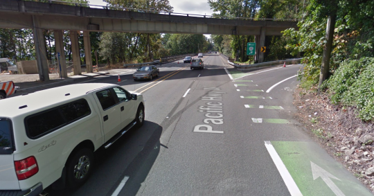
Buried inside 115 pages of analysis of Barbur Boulevard, a “safety audit” released Monday seems to have come up with something interesting: a pretty solid new idea for fixing the dangerous wooded section of Southwest Portland’s most important street.
It’s fairly simple. Instead of losing a northbound auto lane from Miles to Hamilton, one of Barbur’s two southbound auto lanes could peel off at Capitol Highway.
South of Capitol Highway — which is where 40 to 50 percent of southbound Barbur traffic exits anyway — the street could be restriped to add continuous bike lanes across a pair of narrow bridges, ending the current situation that pushes bikes and cars to merge into the same 45-mph lane.
This was one of seven scenarios highlighted in the road safety audit commissioned by the Oregon Department of Transportation that we covered yesterday, but it wasn’t until we called around to several of the engineers behind the audit that we started to realize how much the “southbound drop lane,” also known as “Option #5”, stood out.
“It felt like southbound made the most sense, because a lot of the traffic was getting over to the right lane,” said Carol Cartwright, an ODOT roadway manager on the audit committee.
Here’s what the southbound drop lane concept has going for it:
It’d make driving much safer on the most dangerous stretch of Barbur
(Image: Google Street View.)
It’s a myth that the Barbur Woods safety problems are all about people biking. They’re mostly about people driving.
In part because so few people are currently willing to bike on this stretch of Barbur, no one has actually died while biking there. The people who have been dying on Barbur have been in cars or (in two cases) on a motorcycle.
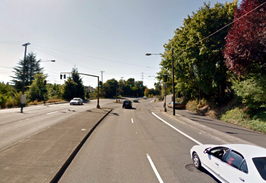
Removing one of the two southbound auto lanes south of Capitol Highway addresses the single biggest safety problem on the wooded stretch of Barbur: extreme speeding by people driving southbound south of Capitol Highway, toward Burlingame and Hillsdale. At least five of the 10 people who’ve died on this stretch of Barbur over the last 10 years were in this situation.
The safety benefits of going from two auto lanes in the same direction to one are well-documented, but mostly boil down to the fact that with only one lane, the most reckless drivers aren’t tempted to weave through traffic. Last year, an ODOT construction project took Barbur down to one lane in each direction. That led to about one minute of additional rush-hour travel delay, but a 68 percent drop in extreme speeding.
That’s no coincidence. The Federal Highway Administration says that restriping streets to remove traffic weaving reduces collisions by 19 to 47 percent.
It might have even less impact on congestion than removing a northbound auto lane
(Image: Portland State University PORTAL system)
The biggest misconception about Barbur Boulevard — the fundamental thing that’s been holding improvements back for years — is the understandable but false assumption that removing one of two auto lanes means a street can only carry half as much traffic.
That’s mostly true on a freeway, but Barbur isn’t a freeway. It has stoplights. As long as the traffic signals on each end of the Barbur Woods are letting through approximately the same number of people on each green light, it doesn’t matter much how many lanes the street has in between.
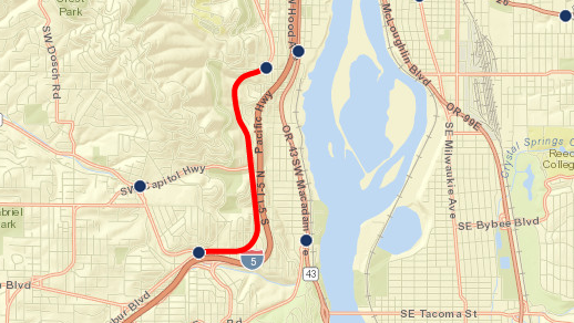
That said, there’s one big intersection right in the middle of the Barbur Woods: Capitol Highway curls west towards Hillsdale. During the morning rush hour, 50 percent of the southbound traffic peels off there. During the evening rush hour, it’s 40 percent.
If about half of the southbound traffic vanishes south of Capitol Highway, what’s the point of the second traffic lane?
Advertisement
It’d fix one of the worst gaps in the region’s biking network
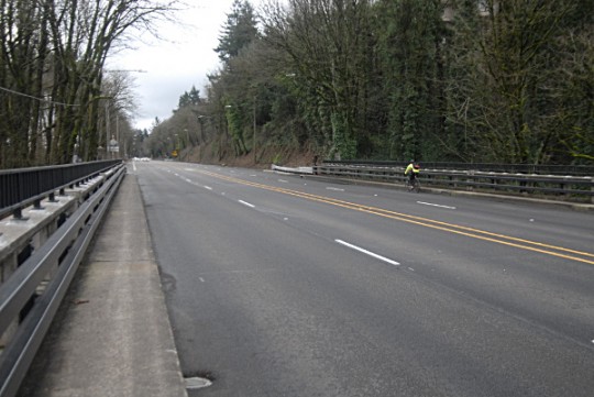
Carved out for a 19th-century rail line, Barbur Boulevard is the only flat connection between Southwest Portland and most of the rest of the city. Forcing bikes and cars to merge into the same 45 mph lane isn’t just nerve-racking for people driving, it’s a dealbreaker for almost anyone who might be interested in biking.
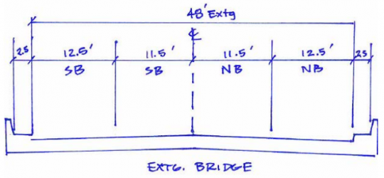
When Barbur crosses the two bridges just south of Capitol Highway, its lanes are 11.5 to 12.5 feet wide.
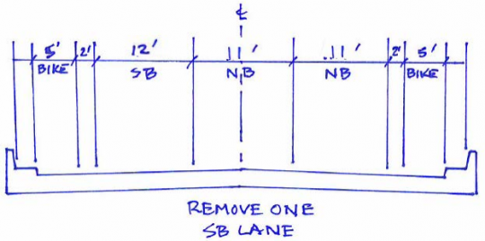
If that were switched to two 11-foot northbound auto lanes and one 12-foot southbound auto lane, there’d be room for comfortable buffered bike lanes on both sides of each bridge.
What’s more, there’s room on the rest of Barbur to narrow the travel lanes a bit and add a painted buffer (or even some sort of thin physical barrier, such as flexposts) that could turn this into a genuinely nice route between the densest parts of Southwest Portland and downtown.
It responds to one of ODOT’s main concerns: Spillover from I-5
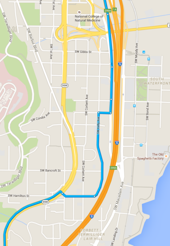
Over the last few years, the Oregon Department of Transportation has said over and over again that Barbur Boulevard plays an important role as an escape valve for traffic when trouble hits Interstate 5.
Whatever you think of that theory, here’s something indisputable: this doesn’t apply nearly as much in the southbound direction. Unlike northbound I-5 traffic, which has a relatively intuitive spot to jump onto northbound Barbur five miles to the south, traffic that’s southbound on I-5 can’t get onto Barbur without a zigzag through narrow streets in this Lair Hill neighborhood:
“Accessing Barbur Boulevard from I-5 southbound is challenging and may only attract motorists already in downtown Portland,” the safety audit writes.
Dropping the southbound lane at Capitol Highway would still have challenges
(Photo: M.Andersen)
Like all the options explored in Monday’s safety audit, Option 5 has downsides.
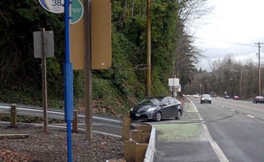
There’s a bus stop at Southwest Barbur and Parkhill that, as of 2012, sees two people get off (and zero people board) on the average weekday. If TriMet buses continue to stop there, they might or might not be able to pull fully out of the way of a single southbound travel lane. There’s another bus stop 2,000 feet north, beneath the Capitol Highway overpass, that sees one person get off per weekday and would also be affected. (Last spring, The Oregonian enshrined that one in video as maybe the worst bus stop in the city.)
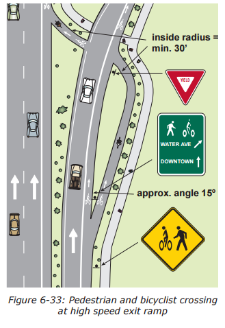
Another complication is that southbound bike traffic would somehow need to cross the drop lane at Capitol Highway. If it’s restriped into a drop lane, it might feel even more like an offramp than it already does.
Depending on how the turn lane works, there might be enough room here in the existing roadway to swoop the bike lane around and create a less acute angle for bikes to cross the ramp. Here’s an image in ODOT’s bikeway design guide that suggests the geometry involved:
On the other hand, one of the main problems with this intersection is that so many cars fail to signal their right turns, so it’s impossible to know, while biking, whether a car is about to zoom up Capitol Highway or zoom under Capitol Highway. If the right lane were a drop lane, someone biking or walking here would know that every car in the right lane was preparing for a turn.
In any case, it’s clear that a bit more design work would be required to know whether this might be an adequate compromise. On Monday, ODOT spokesman Don Hamilton said that ODOT’s Portland regional manager, Rian Windsheimer, will make the call about whether to assign anyone to look at it and at the other options explored here.
“We’ve already decided this requires further study,” Hamilton said. “That’s going to begin soon. … It’s a question of how and when.”
Everyone who drives, bikes or walks on Barbur should hope that work doesn’t wait until after another person dies.
— Michael Andersen
(503) 333-7824
michael@bikeportland.org
@andersem




Thanks for reading.
BikePortland has served this community with independent community journalism since 2005. We rely on subscriptions from readers like you to survive. Your financial support is vital in keeping this valuable resource alive and well.
Please subscribe today to strengthen and expand our work.
The worst option is doing nothing.
This seems like a win win with very few trade offs compared to the safety benefit. Speeding on the Hamilton curve is literally out of control. People are taking it so fast they are losing control of their vehicle and crashing.
Let’s make it safer for those people and make Barbur a better option for people on bikes. Can we just please call this something else besides “road diet”, how about “option 5”? or “excessive speeding reduction plan”?
We just need to call it something that the majority of people can’t help but like the sound of, like the “Taxes Are Bad Plan!” or the “Save The Bald Eagles Plan!”
“Barbur Vision Zero Plan”?
ODOT Knows?
Thanks ODoT for studying this in detail with a RSA…it is always enlightening to take a fresh outside look at facilities using data to check long held assumptions.
[I need to now read the study to see if there are any other nuggets missed.]
Fantastic idea. Seems like a no-brainer (enter cynical remark re that therefore it won’t be done).
I’ll reiterate part of my comment from yesterday, though. If they build up the bike-portion roadway over the bridges to the sidewalk level, it’d be a low-cost way to get wider bike lanes and grade-separation on that part. (other portions subject to the proposed lane reduction have the existing bike lane to make a wider, but not grade-separated, bike lane).
call it the “NO mountain biking plan” and it’ll get support instantly
Toss in the words “art” or “children” into the title and it’ll become wildly popular.
Also put a bird on it.
I’d suggest that it become a low speed exit ramp with a signal that stops auto traffic whenever a bike or ped calls for a signal change. Drivers go too fast to make the crossing totally safe.
Something to slow the off ramp there. Turn the Yield sign 90° and it works.
Agree. I hate it when engineers decide to make through traffic yield to traffic that is turning off the highway/roadway. It’s outside of normal standards. Just because it involves bikes, it somehow becomes acceptable to give us degraded treatment.
And a raised crossing table.
Excellent write-up, Michael. This is definitely an attractive option.
One key tweak this option needs, though, is at least one widened sidewalk. The current 30″ sidewalks are not even legally sidewalks. They’re “maintenance walkways” and they’re pretty scary. It was surprising that none of the proposals addressed pedestrian space on the bridges.
That is a good idea for when the bridges are rebuilt. But right now there is nearly no pedestrian use of this road. When you are walking it’s not as as big of a deal to walk up steeper slopes for short distances. Barbur has the least climbing from Portland to Multnomah Village and other parts of SW Portland: https://goo.gl/maps/HQJNAmtBScm (518 feet of climbing, 32 minutes per Google, 5.0 miles)
By comparison the route via Terwilliger is barely longer (0.1 mile), but has more climbing and takes an extra 10 minutes by bike: https://goo.gl/maps/fWBBH5LFMV72
On foot you can take the pedestrian staircase at Whittaker which makes the Terwilliger route even shorter than the Barbur option (by 0.1 miles…), and much more pleasant.
How much pedestrian traffic uses those “sidewalks”? If very little, then the bike lanes could be elevated to the same level as the sidewalks, and the two combined to be a shared bike/ped path appx 9.5 feet wide. For cyclists, the negative of occasionally having to carefully pass a pedestrian should be outweighed by the positive of being protected by a curb from 50 mph car traffic.
At the bus stop, there could be a “bump-in” (not sure of the correct term), allowing the bus to pull over and stop without blocking traffic. Ramps at either end of the “bump-in” could allow cyclists to use the space as a continuation of the bike path when there is no bus stopped. Realistically there will hardly ever be a bus sitting there.
Maybe, but the concrete would add load to the bridges. How many buckets of paint do we need? We can do it this weekend, yes?
When we rebuild the bridges for the SW corridor transit work, we better not build any 9ft bikesidewalks. Bikesidewalks are so over.
I like the idea depicted in the last diagram. With a separated bike path that crosses the slip lane at a right angle, it would improve safety and visibility. I’d maybe add an induction loop triggered rapid flash beacon as well.
Adding seven foot bike lanes would be a good start, but if the speed limit and 85th percentile speeds are still in the 40’s, then some sort of physical separation should be implemented. Start off with plastic bollards in the buffer zone, then improve with a concrete curb later in the future.
A yield sign should face the auto traffic. We don’t need the swoop-around if you place the yield sign (and a bar of triangles?) one car-length back from the cross.
Way too much over-thinking the bus stops for 5 riders. With the road diet, the southbound stop at Parkhill could be moved north 200ft and be next to the stairs, with a walking lane where the bike lane is now. The more complicated southbound stop under Capitol would be less than 1000ft away at that point. Do we need it? I ride a bike because the bus stops so often that it takes too long?
The red electric trail might connect more people to the Capitol stop, but I really hope we paint this stroad a few years before that gets built.
Didn’t the BTA petition ask for exactly this road diet?
Great to see ODOT using creative thinking and come up with a pretty solid proposal.
An idea for dealing with the bike/car conflict if the lane becomes right only:
Use the same kind of sensors on the bike lane that trigger a signal to alert motorists to watch out on the bridge for bikes, but instead they could trigger a signal to motorists that they should stop (think of those “ramp signal on” freeway signs), and then treat the conflict area between bikes and cars as a little intersection and use signals to tell when each mode can go (either one at a time like you’d see on the onramp or timed like you’d see on a city intersection, or perhaps just a sign to motorists to watch and yield to people on foot or bike).
Don’t know how doable this would be but Instead of the bike path crossing the ramp intersection, just do a SE Division/205 path dig under. One big culvert and a cement pad.
My preference would have the SB bike lane be moved to the NB side, remove one of the SB lanes, and shift things over. I think that would give us some space for a decent sidewalk too.
“…the understandable but false assumption that removing one of two auto lanes means a street can only carry half as much traffic.
That’s mostly true on a freeway, but Barbur isn’t a freeway. It has stoplights. As long as the traffic signals on each end of the Barbur Woods are letting through approximately the same number of people on each green light, it doesn’t matter much how many lanes the street has in between. …” andersen/bikeportland
How many minutes would the signal cycles have to be to do this? Double the stop light cycle length of a two lane road, to have one lane of traffic pass the same number of vehicles as does a two lane road. So a two minute light cycle would become a four minute light cycle to accomplish this. One and a half minute becomes three, and so on.
It’s an interesting idea to constrict Barbur’s south bound lanes from one to two at the Capitol Hwy exit. Tricky. Viability would seem to depend on presumptions that future growth would not need the additional capacity that a full two lanes of southbound Barbur past the Capitol Hwy exit would offer.
For the short term, maybe it would be worth trying though. If there were bike lanes across the two bridges, to avoid steeper climbs of less traveled routes, it’s possible that more people than do now, would be willing to ride alongside the high volume of motor vehicle traffic common on Barbur.
The nice thing about the future-growth question is that if the traffic trend on Barbur someday reverses (auto counts on Barbur have actually trended down about 10% over the last 12 years) and we haven’t yet rebuilt these bridges, there’s no reason we couldn’t restripe things back to the way they are now.
BikePortland.org, of course, would be staunchly opposed to that rollback and generate lots of infographics about the situation using Google Holograms. 🙂
It’s probably a bigger deal in reality than it seems to laymen/sidewalk supervisors, but experimental paint stripe reconfiguration to try out road issue solutions, seems like it must be one of the lowest cost means of finding out how things like road diets and lane terminations would work, in actual practice, rather than from hunches or computer simulations.
At least for on a relatively short section of road such as over the bridges on Barbur. Still sounds like hundreds of thousands of dollars though. But I hope state officials have at least given some thought to taking this route.
Why not make a mup with a tunnel? Are people that expendable?
I think this idea was actually suggested last year – I know it occurred to me once when I was on Barbur (in a car) and became aware of how about half the southbound traffic ends up turning up the hill.
But don’t tell ODOT that. Best to let them think they came up with it. 😉
Hey, you forgot that Trimet will be building a MAX line down the middle of Barbur. So figure on removing an additional… what, 20′ (give or take) from the street width for the tracks.
Nobody is “forgetting” that. The SW Corridor long term plan has been brought up in most of the numerous Barbur threads over the past year.
But SW Corridor is 10 or 15 years away. We need a solution much, much sooner than that. Also, SW Corridor may well end up as BRT rather than light rail, which wouldn’t monopolize ROW the way rail does.