bikeway recommendations
for Southwest Portland.
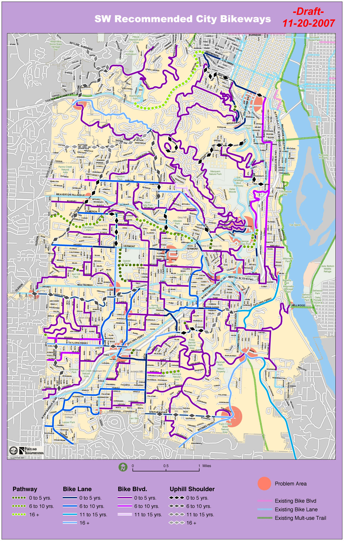
(Click to enlarge)
A group of bicycle advocates in Southwest Portland have unveiled their latest map of proposed bikeway improvements. The group, SWTrails, has been working for nearly a year to come up with recommendations that they plan to present to the Portland Office of Transportation (PDOT) for consideration in the ongoing update of the Bicycle Master Plan.
Central to SWTrails’ effort is the creation of a map that includes the types of bike facility improvements they would like to see. Back in March, I shared the first version of this map and I just received the latest version this morning.
These bikeway recommendations are the result of well over a year of planning that began in September of 2006 with an organized ride through inner Southeast Portland to survey how that area had become so bike-friendly.
SWTrails has also held a series of meetings and rides sponsored by SWTrails over last summer. SWTrails has also been working closely with PDOT staff on this project.
Here’s more about the map from SWTrails representative Keith Liden:
“The map represents a draft recommendation regarding the type of bicycle improvements and the priorities for completion. A major emphasis of the recommendations is to rely on a low-traffic street system of “bicycle boulevards” with a pleasant and safe bicycling environment – something that is generally lacking in SW Portland today.”
SWTrails has scheduled an open house event to encourage Southwest residents to review the draft recommendations and offer suggestions on how to improve them. If you’d like to weigh-in on this effort, here are the open house details:
-
SWTrails Bikeway Improvement Open House
Thursday, December 6th – 6:00 – 8:30pm
Multnomah Arts Center, Capitol Room
7688 SW Capitol Highway
For more information about SWTrails and riding in Southwest Portland contact Keith Liden at (503) 224-4066 or Liden(at)pbworld(dot)com.
Citizen advocates in other Portland areas in need of bikeway improvements should take note of this organized, strategic, long-term effort by SWTrails to improve riding conditions in their neighborhood.
Download the map:


Thanks for reading.
BikePortland has served this community with independent community journalism since 2005. We rely on subscriptions from readers like you to survive. Your financial support is vital in keeping this valuable resource alive and well.
Please subscribe today to strengthen and expand our work.
SW Trails did a spectacular job with this – it would be great to see PDOT implement this virtually unchanged. If even half of these proposed routes were implemented, it would go a long way towards solving some of the problems with biking in SW.
Great news!
I do have a small question about the map. What does the key mean when it identifies routes as \”0-5 years\”. \”5-10 years\” etc etc?
Is this the timeframe from today in which these improvements would ideally have been implemented? Just curious.
Thanks to the SW Trails group. It looks like a tremendous amount of work that you have done. I hope that PDOT can integrate the recommendations into the upcoming Transportation bond/tax and start building some of the recommendations.
I am going to try to make the meeting to ask some questions. Thanks again for your hard work.
Wow, so many purple paths! I hope all their hard work pays off.
Looks awesome!
My only suggestion for the map maker would be to use a more different symbol for the bike boulevards – I have trouble with colors and it is difficult to tell what is a bike lane and what is a bike boulevard.
Terrific!
Don\’t laugh, OK, but is there a group in Beaverton doing the same kind of work? A lot of bike blvds drop off the edge of the world on the left side of the map. There be dragons!
I thought that SOUTHWEST covered a bit more ground than that map indicates.
I would love to see this group expand their self-imposed boundaries to include the REST of the SOUTHWEST part of Portland instead of stopping in the middle like they currently are.
That said, I\’m glad that there\’s a group who is pushing for infrastructure outside of the downtown core area to the southwest.
Looks like Tigard [and Beaverton, King City, etc] are on their own – the boundary is SW PORTLAND [as inferred by the work of the SW Portland group dealing with PDOT most likely]. The map delineations are definitely City of Portland.
Tigard apparantly needs a grop to pick up the ball and coordinate with it\’ neighbors….
If you want change in Tigard, Beaverton, Hillsboro, Tualatin, Wilsonville – go start agitating the locals (politely)
No one was doing anything in Clackamas County, so I started getting involved. Heather Andrews and Matt Menely started getting involved. And now there\’s a core group of people who are influencing bike improvements in Milwaukie and beyond.
Until someone from that area wants the improvements enough to do something concrete, they\’ll never happen – and it truly will be \”here ye be dragons\”
Start a listserve, post the info here, the Shift list, the BTA blog, bikeforums.net – wherever cyclists congregate online. Go to city council meetings, other public meetings. Get involved, write and meet your local officials. Find out who\’s in charge of transportation planning.
Ghandi was right – BE the change you want to see. You\’ll be surprised how many people come to help once one person starts doing something in public. No one wants to be first, but plenty of people are willing to help if someone else takes that first step.
FYI… Although this map doesn\’t show any plans for SW Scholls Ferry Rd., Multnomah County recently got a planning grant from the state to look at redesigning the section that\’s outside the Portland city limits… basically from Hamilton up to Sylvan.
A key goal will be to make it safer for bikes and peds to go up and down this hill.
I\’m on the county bike/ped citizens committee that will be advising staff… and I\’ll keep Jonathan up to date as the project progresses… including when and how to submit ideas.
I am one of the authors of the map. Thanks for the comments. Regarding the timing (0-5 yrs, 6-10 yrs, etc), this was simply a first draft to identify the relative importance and sequencing for completion. The current Bicycle Master Plan places most of the emphasis on bike lanes on major streets – typically very expensive. As a result, few have been provided. This proposal focuses on a bike boulevard system first because it can provide a significant improvement over the current system at relatively low cost. Unless they are critical for making the bike boulevard system work, the more expensive improvements, such as widened streets for bike lanes, are given more time to be completed.
Regarding the readibility of the map, we will work to make this easier to read and understand.
The plan generally focuses on streets that are under city of Portland jurisdiction. Although the city doesn\’t have any direct ability to improve Scholls Ferry Rd. for example, I don\’t see any reason why the SWTrails recommendation couldn\’t include a category of suggested improvements for state and county streets within the city.
Hope to see you at the open house!
Thanks for Keith and the others for doing this. I will try to make the open house.
Some comments:
I know that the name of your group is \”SWTrails\”. Nonetheless, I would like this plan better if the multi-use paths (MUPS) were de-emphasized. I\’m concerned that money that would otherwise be used for on-street bike facilities will get appropriated for pathways instead.
Pathways only seem attractive because people say that they will ride more if they have a grade separated pathway. I don\’t believe it. Traffic planners have been trying to cajole reluctant would-be riders onto bicycles with grade separated pathways since the 70s. They didn\’t work then. They won\’t work now. Reluctant would-be riders will always find another excuse not to ride. And the resulting facilities are almost worse than nothing. Consider, for example, the path on the north side of Garden Home Road west of Oleson. Every side street is signed for a stop sign for the bike path. Or, consider the Fanno Creek trail, which features blind curves, people walking across blocking the path, and pavement that\’s buckling due to tree roots. As was pointed out in the earlier thread on the attack on the Springwater Trail article, there\’s also a security concern with grade separated paths. The trail that you propose to extend Slavin would create one more area that\’s out of sight, and therefore, a potential security problem.
I\’d rather see the money that would be spent on that path go instead to widening the bike lane on Capitol between Barbur and Terwilliger to a standard width.
Another place to put that money is in making it a little bit easier for bicycles leaving downtown. Draw a purple line on Hooker between Barbur and Corbett. Put a bicycle activated 4-way signal at Hooker and Barbur. There\’s already a crosswalk signal there; it shouldn\’t be that much more expensive to add lights for Hooker traffic. And change the stop sign at Hooker and 2nd so that the 2nd Ave traffic has to stop. Hooker to Barbur to Corbett, for northbound bicycle traffic, is a better alternative than going north on 4th to where the bike lane ends at a double lane freeway off-ramp.
I agree with the other posters that it\’s too bad that the map ends at the city limits. I would very much like to see crash corner, otherwise known as Beaverton-Hillsdale/Scholls/Oleson improved.
Finally, there is a Washington County group that\’s trying to improve bicycle transportation, the Washington County Bicycle Transportation Coalition.