The City of Portland will lead a bike ride to celebrate the grand opening of the recently completed Naito Parkway Reconstruction Project.
(File photo)
The $10 million project was financed primarily by the Oregon Department of Transportation with help coming from the Portland Development Commission and the Portland Office of Transportation.
The grand opening event will happen on June 14th at 10:30 am and will include City Commissioner of Transportation Sam Adams, various project partners including ODOT Region 1 manager Jason Tell, and Anne Naito-Campbell, whose family the street was named after.
After a short presentation at Ankeny Plaza (between Naito and the Skidmore Fountain), the dignitaries will go for a ride on the recently installed bike lanes.
These new bike lanes were installed in both directions last month, but for some reason a glaring gap in the lanes remains just south and north of the Steel Bridge.
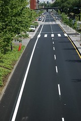
Riding north on Naito
just past NW Everett.
(File photo)
I wonder what the assembled dignitaries plan to do when they come to NW Everett and realize that the bike lane comes to an abrupt end. The smiles will subside when they’re faced with cross-traffic heading onto the Steel Bridge and they’re sharing the lane (on a very narrow shoulder) with high-speed motor vehicle traffic.
A recent comment explained the gap like this:
“…the north end (of the new lanes) is kind of funky. There is a ramp at the end, but it leads to the sidewalk that goes up and over the bridge instead of to the Esplanade and the lower walkway – there is a path to the Esplanade, but it involves a set of steps. To get to the Esplanade with riding on the grass or down the steps, you have two options – exit Naito at the light by Everett Street or continue on Naito past the car entrance ramp to the Steel Bridge (which requires crossing that entrance ramp and taking the lane) – there is a ramp up onto the sidewalk just past there by which you can gain access to the Esplanade.”
While I’m thrilled to see these new bike lanes, and it’s great to have an option off the crowded, multi-use waterfront path, PDOT and/or ODOT should put their heads together and find a way to connect this new bike lane with existing ones just north of the Steel Bridge.
This connection is imperative if the City wants to encourage cycling and it’s the type of thing that can add teeth to their claims of wanting to build a “world-class” bike-friendly city.
Once they close this gap, we’ll really have something to celebrate.
For more images, check out my Naito bike lanes photo gallery.


Thanks for reading.
BikePortland has served this community with independent community journalism since 2005. We rely on subscriptions from readers like you to survive. Your financial support is vital in keeping this valuable resource alive and well.
Please subscribe today to strengthen and expand our work.
Typical of PDOT – when the going gets tough, PDOT gives up. Bike connections at the north end of Waterfront Park are boogered up everywhere, not just on Naito Parkway.
I agree with Burr. It\’s a bit tough getting out of the north end of town. My ride in on Broadway is great, but there is no equivalent bike lane going the other way. Like many others, I\’m forced to wind my way through old town/Chinatown, which is even more fun now because of the light rail construction.
But it\’s always nice to see more bike lanes, even if it is a road to nowhere.
And what about the south end? I get on Naito at Harrison. The north bound lanes before the newly paved section are rougher than hell. I\’m afaid to take a hand off the bars to signal a lane change around the traffic backed up for the Hawthorne bridge lest the chop throw me to the pavement.
Are there any plans to repave the south end?
Not to mention the lack of anything friendly for SB commuters heading for the Hawthorne bridge (I work in Big Pink). Ideally they need to let us onto the decommissioned Hawthorne ramp – but no such evidence of that yet.
I want to be there at the end to watch all the big digs make their decision on where to go at the Steele bridge. I suggest that a couple of the rides leaders get their game plans on…and do a couple of practice runs before they make asses of themselves.
It is not bad as far as it goes, which is where? I have not gone north past Oak. How far north does it go? It seems to disappear after going south just past the Hawthorne Bridge. There is a ramp to the abandoned HB cloverleaf, but its use requires a very abrupt reversal to use the wheelchair ramp at the far end of the sidewalk, or a hop over the curb. Overall, it seems to be rather a half-baked plan by a half-baked engineer who doesn\’t ride a bike.
I just took the new lane SB, nearly from beginning to end.
There\’s a sewer grate at the northern end of the SB bike lane that has bars parallel to the direction of travel. It\’s one of those old-school, non-retrofitted tire traps. I thought that the City had a policy to replace those with bike-safe grates.