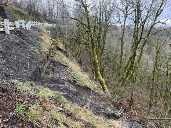
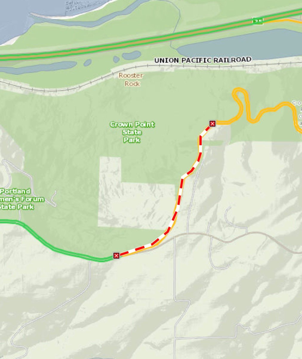
Soil instability has closed a portion of the Historic Columbia River Highway (Hwy 30) that’s popular for cycling on. During last week’s rainstorms, the Oregon Department of Transportation issued a notice that a section of the highway that sits on a well-known landslide had shifted. The location is just east of the Larch Mountain Road turnoff and before you begin the descent down to Vista House.
The road has been closed since last Wednesday (March 12th) evening due to “roadway settling”. According to ODOT this part of the highway sits in an ancient landslide and has been prone to cracking over the past decade. Below is a fun bit of history for those who know the spot (it’s pretty unforgettable given the views and general beauty of the surroundings):
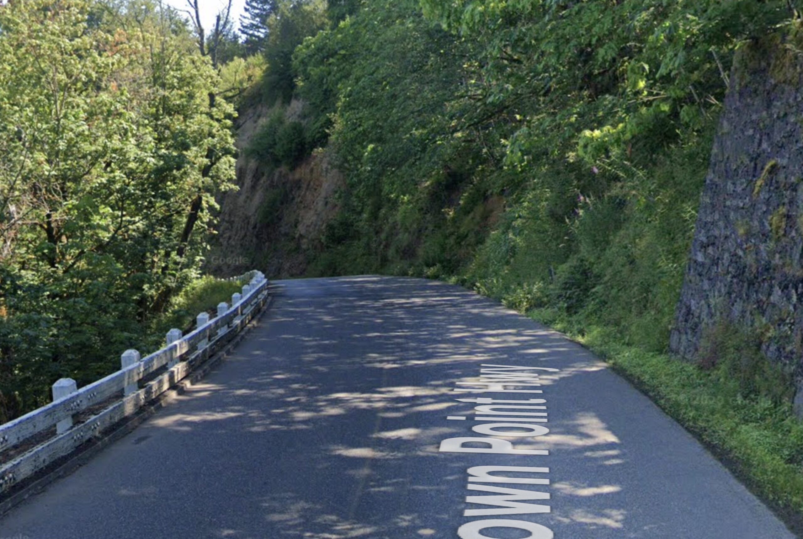
The original design for the highway at this location was a viaduct, or a bridge over land, though the structure could not accommodate the continuous movement of the landslide, and the viaduct was removed in the 1960s when ODOT built the current alignment. In 1983, and then again in 2007, ODOT constructed a retaining wall to support the Historic Highway. Continued ground movement, sometimes up to 12 inches in a year has required annual re-paving and reassessment.
What’s not so fun is that, “This month, geotechnical engineers noted that the settling has accelerated, and additional structural issues downslope have caused safety concerns,” ODOT said in a statement. As a result the road is closed between the Larch Mountain Road split and Vista House. That means a key connection to rides in the Gorge is no longer available. Car drivers can use I-84 as a detour option, but that’s not really feasible for bike riders due to safety concerns.
And no, unlike we’ve seen Multnomah County do with similar closures, this is a full closure and bicycle riders are not allowed to skirt through. According to ODOT spokesperson Ryan McCrary, who I contacted today for an update, a geotechnical team has been onsite surveying the area to figure out what it will take to make needed repairs. Currently there is no timetable for reopening.
“We hope to be able to reopen once the survey is complete,” McCrary said. “A more comprehensive repair effort will get underway when the weather improves, likely late spring early summer.” McCrary added that any future closures will continue to apply to all users, so don’t even think about rolling past the barricades. Stay tuned for updates once it’s reopened.
###
UPDATE, 3/25: The road has been reopened. In a press release today, ODOT calls it a temporary reopening.

")


Thanks for reading.
BikePortland has served this community with independent community journalism since 2005. We rely on subscriptions from readers like you to survive. Your financial support is vital in keeping this valuable resource alive and well.
Please subscribe today to strengthen and expand our work.
Any chance that NE Columbia ave will be available for ped/bike access?
It runs parallel to hwy 30 and connects crown point to the road fork at larch mtn rd.
…to ride on a section of the historic highway with no cars. I wouldn’t even consider it!
You could ride it for 1/2 mile until Crown Point and after that the traffic is going to be a lot worse because of this. Out and back traffic from I-84 to Crown point will be a nightmare.
This is a real tragedy unless they close the entire road which they won’t.
perish the thought.
I’m thinking about it RIGHT NOW.
well stop, because ODoT said NO.
It’s steep and gravel but the intrepid can detour via Larch Mountain Rd. & Alex Barr: https://ridewithgps.com/routes/50026095
Yes Alex Barr is really cool. Highly recommend for more adventurous folks.
Looks like diverting up Larch Mtn Road and descending Alex Barr is still an option (and the reverse). If you’re comfortable on a bit of gravel, it’s a pretty fun way to do it.
I’ve taken this route. It’s easy. I ride with a Trek 520.
The highway is also closed further down for a small section by Multnomah Falls for construction, though they say it should be open by Memorial Day
Columbia Gorge Express is going to be busy this summer
https://www.ridecatbus.org/columbia-gorge-express/
Looking at Google Maps it appears there is a small road just behind the closed section called NE Columbia Ave that links off Larch Mtn road and connects at the top of the Vista House parking lot. I’ve never ridden it, but does anyone know if it would be a viable detour?
After also looking at Google Maps and then looking at TripCheck (tripcheck.com) to see where the road is closed. It appears that NE Columbia Ave could be a good detour. Hopefully someone with personal knowledge of that road posts here to let us all know.
Jonathan has indicated that I84 is not a safe alternative. I understand his position but I have also seen bicycle riders on 84 in the Gorge. I would consider it but I also spend a lot of time riding HW30 where at time is busy with autos running at 65 to 70mph. I also travel I84 a lot for my job. It can be a scary drive at times. Winter with snow and Ice of course. Its worse after a heavy rain because it doesn’t drain off and leaves large sections of standing water. I have seen more accidents because drivers do not slow down and hydroplane into the concrete barrier and other cars.
Interesting. There’s no apparent signage in Streetview on either end, no street name or “private”, or dead end.
It’s… complicated? From the Vista House side, it looks like local homeowners have put up gates and are using Columbia Ave. as a private driveway. On the other hand, Multnomah County GIS shows it as a public right-of-way the whole way through, albeit as an unmaintained “local access road”. Comparing that map with the photo, I think the one on the right would be Columbia Ave., and the left one is “Thor’s Boulevard”, so named because the area from Crown Point back to Larch Mountain Road was once platted out as a (failed) 1910s subdivision called “Thor’s Heights”.
Anyway, that little right-of-way disagreement would need to get resolved somehow, and it’s far from the only case in the Gorge where the county says a road is public, but local landowners have put up gates and the county hasn’t done anything about it. NE Henderson Road runs between Alex Barr & Bridal Veil and could make a great car-free alternative to the HCRH for that stretch, except it’s currently gated on both ends. Latourell Hill Rd. (aka Road 377) runs steeply downhill from Larch Mountain Rd. to the HCRH at Latourell, where there’s a gate and a No Trespassing sign. Again, I have no idea how county right-of-way issues get sorted out, but it seemed like it was worth pointing out.
Tried to ride it last weekend. It doesn’t connect and turns very private.
thanks for the tires-on-the-ground report. Odd there’s no dead end or private signing.
Why not rebuild it for only pedestrians and bicyclists?
True, with no cars going through, they’ll need a lot less maintenance.
It’s a real blow to me, since as a bike-only photographer this means I can’t take any gigs in that area anymore, quite the popular site for elopements, engagement session, etc.
This section of the highway was reopened this morning – per ODOT it will eventually close again for repairs, but no timeline given.