

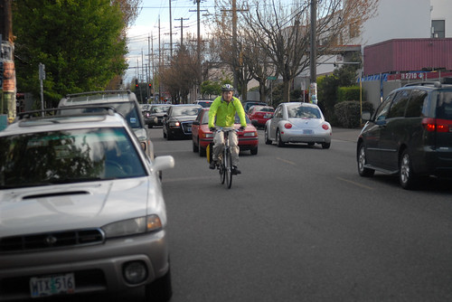
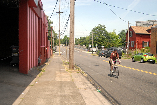
(Photo © J. Maus/BikePortland)
The first on-street, low-stress route that (more or less) connects Portland’s northern and southern borders is likely to start construction in April or May.
That’s pending federal approval, which city project manager Rich Newlands predicted will arrive this month. A $2.4 million federal grant earmarked for biking improvements paid for almost all of the project.
The 9.1 mile 20s Bikeway has changed quite a bit since it was introduced in 2013 as a more or less straight line running directly through many of Portland’s fastest-growing neighborhoods, plus Reed College, Concordia University, Grant and Cleveland High Schools and two major grocery stores.
Here’s the original concept:

-Click to enlarge-
And the final route:
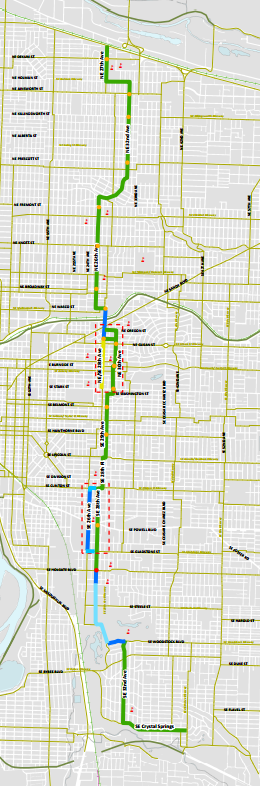
Most notably, the main route jogs to avoid the two biggest commercial nodes, at 28th near Burnside and 26th near Clinton, because the city decided that on-street auto parking directly in front of the stores was more important than all-ages bike access to the future of those districts.
The main route jogs to avoid the two biggest commercial nodes, at 28th near Burnside and 26th near Clinton, because the city decided that on-street auto parking directly in front of the stores was more important than all-ages bike access to the future of those districts.
There’s also a new northeastward jog at the northern end of the bikeway, running along 32nd Avenue north of Alameda Ridge. That’s intended to provide a relatively flat route up the ridge (which will get a new bike lane for people climbing the hill) and follow existing bike traffic patterns in the area.
In the middle, the route has been shifted from 28th to the lower-traffic 26th, further from Grant High School and the Grant Park Fred Meyer, in order to avoid a difficult corner at Halsey or any parking removal between Interstate 84 and Broadway.
At the southern end, the route has also been shifted from 28th Avenue (where residential curbside parking would have been removed for buffered bike lanes) to 32nd Avenue, where people biking to connect to the Springwater Corridor will share the road with cars and the No. 19 bus on a street without speed bumps or other traffic calming measures. (The Eastmoreland Neighborhood Association objected to adding speed bumps, and the city agreed with them. The city did, however, reject the ENA’s subsequent objection to improving the bike lane on four blocks of Woodstock Boulevard in order to preserve curbside parking in front of six large houses overlooking Reed College.)
Near Powell, the city has agreed to remove one of southeast Portland’s most-ridden bike lanes from 26th Avenue if the Oregon Department of Transportation continues to insist on it. (The state required the bike lane removal from 26th as a condition for approving a new bike-pedestrian traffic signal at 28th.)
The city hopes to draw on the next year or two of ridership data to persuade the state to save the 26th Avenue bike lane, but ODOT says it will not reveal what if anything might change its mind.
Commercial greenway concept scrapped without discussion as money ran low
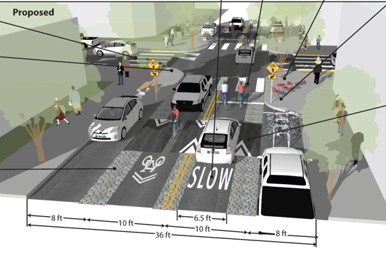
In the 28th Avenue business district near Burnside, the city is planning to install speed bumps and a lower speed limit of 20 mph.
Two years ago, the city promised the project’s citizen advisory committee a separate discussion about that area in a subcommittee. One member of the committee who works as a traffic engineering consultant recruited two peers to create a pro-bono concept for a “commercial greenway,” adapted from Dutch infrastructure, that would combine fire-friendly speed bumps, cobblestone pavement, curb extensions with trees and raised sidewalks.
“This looks great,” said Scott Mapes, owner of the nearby restaurant La Buca, when the concept was presented to the advisory committee. “It’s the best thing I’ve seen so far. Bravo!”
Mapes’ enthusiasm for the commercial greenway concept, which wouldn’t have removed much if any parking, came after 57 nearby businesses signed a letter opposing parking removal and sent it to Transportation Commissioner Steve Novick.
Last spring, though, the city quietly scrapped its promise to discuss the greenway concept further. Kirk Paulsen, the advisory committee member who presented it, said Newlands told him that “the project simply ran out of money.”
City spokesman John Brady said Wednesday that the city’s lead traffic engineer “did not feel that the proposed elements delivered enough bang for the buck, that is, the value in traffic calming didn’t justify the costs.”
(Update: in a comment beneath this post, Nick Falbo, one of the volunteers who helped illustrate the commercial greenway concept, offers some similar criticism.)
Advertisement
New signals, new sharrows
Despite all those compromises, the route definitely improves north-south connections to all of these important destinations and others.
On today’s eastside biking grid, north-south routes through some of the most bike-heavy neighborhoods in the United States are left mostly to improvisation in the 2.5 miles between NE Rodney/SE 7th and NE 47th/SE 41st. The 20s Bikeway will change that using a trail of sharrows; new traffic signals or half-signals at Broadway, Burnside, Stark, Hawthorne and Powell; and one new half-diverter that will forbid (though not physically block) northbound traffic onto 28th from Holgate.
One spot that’ll get a big change is the crossing of Interstate 84 at 28th Avenue. The bridge there is slated to receive Portland’s first bidirectional protected bike lane, running along the west side of the bridge. The two bike lanes will each be 5 feet wide and will have a two-foot buffer. On the east side of the bridge, the northbound bike lane will include a five-foot-wide striped bike lane to serve people continuing northbound on 28th.
A few parking spaces will be removed
Between Interstate 84 and Sandy, the city decided to remove a handful of contested parking spaces outside the bar Katie O’Brien’s. We reported in 2014 that the city was considering spending $30,000 to narrow the sidewalk across the street rather than remove those free on-street spaces. (As we reported, the management of Katie O’Brien’s had decided a few years before to not pay a neighbor for parking spaces on a nearby private lot.)
Below is the stretch from Interstate 84 south to Oregon Street. Newlands said Thursday that this design is slightly out of date — the very northern section, near I-84, will actually get a five-foot bike lane on the east side of the street to serve people planning to continue north on 28th.
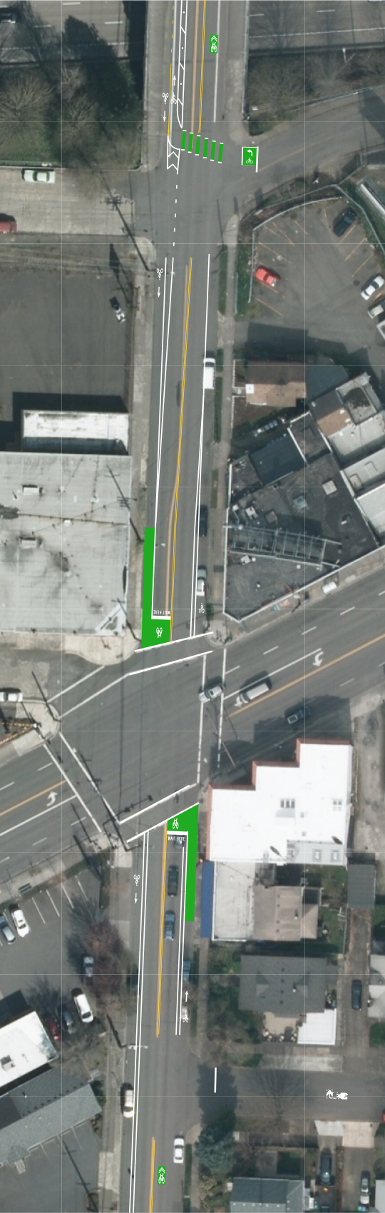
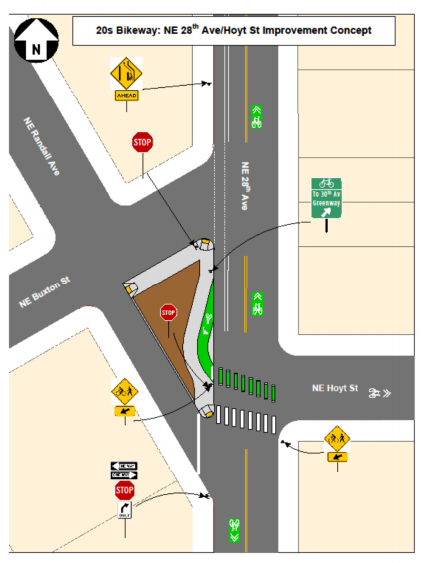
The corner of 28th and Sandy will get green bike boxes in the north-south direction. South of Sandy, the northbound bike lanes will go away and the southbound bike lane will continue to Hoyt, where it’ll sweep left in a “jug handle” design pointing to the new neighborhood greenway that zigzags around the commercial district:
No diverter on NE 32nd despite neighborhood support

(Image: Google Street View.)
The city rejected a recent request from the Concordia Neighborhood Assocation to install a traffic diverter on 32nd, citing its new neighborhood greenway standards that set maximum levels for auto traffic on neighborhood greenways.
“The counts are not even close to the thresholds for consideration,” Brady said in an email. “Instead, we are committed to monitoring conditions over time, and if the traffic counts do get close to the new guidelines then we can start up a process for installing them when needed.”
Stakeholder committee member Paulsen, who lives in Concordia, wrote in an email to BikePortland that the traffic levels are indeed close to one of the triggers for a traffic diverter:
At 32nd Avenue immediately north of Prescott Street on the yet-to-be-built 20s Bikeway within the Concordia Neighborhood, the traffic counts from 2010 (which have likely increased since then) show approximately 50 vehicles per hour in the peak direction. I can only imagine that when some of the stop signs are flipped as part of the bikeway project the route will attract even more cars to cut-through along this route. Compare those numbers to the following…
The alternate guidelines within the Greenway Report state (emphasis is mine): “Alternate Guideline: An alternate vehicle volume measurement based on vehicles per hour may be used in lieu or in addition to ADT: to design, build and maintain for an average of 50 vehicles per hour in the peak direction, understanding that a neighborhood greenway can operate at an average of 75 vehicles per hour in the peak direction, but should be improved or maintained to not exceed 100 vehicles per hour in the peak direction.
The December 2010 counts Paulsen mentioned showed 30 to 32 cars during the morning peak hour and 40 to 58 cars during the evening peak. Brady said the city wasn’t able to look up the exact counts by Wednesday in order to comment.
In his Tuesday email, Brady said the only remaining hurdle is approval by the Federal Highway Administration, which funded this project as part of Portland’s goal to triple the rate of bike use over the next 15 years.
“If we receive approval from the FHWA in the near future, we will most likely start construction in April-May,” Brady said. “The usual caveat applies: if there are unforeseen delays, this start date will also change.”
Learn more about this project in our 30-story archive that dates back to 2009.
Correction 1/15: An earlier version of this post omitted the decision made last summer, but not announced until now, to stripe a northbound bike lane on 28th Avenue’s Interstate 84 bridge.
— Michael Andersen, (503) 333-7824 – michael@bikeportland.org


Thanks for reading.
BikePortland has served this community with independent community journalism since 2005. We rely on subscriptions from readers like you to survive. Your financial support is vital in keeping this valuable resource alive and well.
Please subscribe today to strengthen and expand our work.
When I clicked on the article and saw the first map, I thought “Wow! That looks like a nice route that would get me right to my girlfriend’s house and to my friends’ in SE.”
But after seeing the actual route, I’m not excited to ride it at all. PBOT really needs to give us access to commercial districts in a straightforward, safe way.
Agreed. How is this better than what we have now?
This is hardly worth doing if the commercial districts will be bypassed.
Plus it’s a complicated mish-mash of designs and crossings that is going to confuse cyclists and motorists alike.
In the final analysis, they are ruining 28th as a through route for cyclists; they should go back to the original proposal if they want cyclists to actually use it.
Reminds me of this.
“Last spring the city quietly scrapped its promise to discuss that concept further.”
Portland’s stakeholder process is undemocratic and unfair. In particular, giving business owners and corporations (Hi Starbucks!) more decision-making weight than residents is completely unacceptable.
Please boycott the businesses that sponsored the petition that killed the 28th bike lane (and the commercial greenway proposal).
Boycott Laurelhurst Theater, Staccato Gelato, and Holmans!
And if you want to disrupt these kind of backroom failures in the future, please support or join BikeLoudPDX.
(BikeLoudPDX was organized in the BikePortland comments section by Alex Reedin, in part, as a reaction to the failed 28th process.)
What the city is implying by prioritizing cars over people is that people who arrive by bike are not worthy of supporting those businesses. Because of our transportation mode, we are not entitled to safe access. The city is doing far more to protect people encased in steel and glass than for people directly exposed to traffic violence!
This is a good reminder for me to continue the boycott of these businesses and remind my friends.
Their pressure on the city limited a route that would have improved access to the two schools in that area as well as improving cycling infrastructure.
To say the city “decided” is generous. It is more like the city caved to underhanded tactics from a greedy movie theater owner.
Why does it seem like Rich Newland’s name is always associated with these bike route design failures?
These decisions are made higher up in the city hierarchy.
Rich actually does a fantastic job. His calm composure in the face of angry neighbors is enviable. Instead, direct your anger towards your elected officials, who refuse to put into practice all their talk about being bike-friendly!
If you heard him braving the angry folks at the meeting in Richmond about the Clinto St. diverters you’d think differently. I was proud of PBOT and of Rich Newlands for how they handled the pushback.
Having said that, this 20’s jog-fest is definitely a disappointment to me. The complexity (more turns, greater total length, extra signage and paint,, etc.) is surely also more expensive than doing this straight, no? So isn’t the ‘we’re out of money’ kind of circular?
I’ll step out from under my reporter’s hat to say the same: I’m sure there are ways Rich could be more effective (there are ways all of us could) but the answer is mostly because he’s been the one assigned to difficult/important projects.
Across the board on this project, the most important thing that has been missing has been support from managers and, more than that, from politicians. When politicians are investing virtually zero political capital in a project, staff understandably feel they have no choice but to seek consensus rather than prioritizing change.
other commenters are right. This isn’t about Rich Newlands. He, like many other PBOT staff, are really good at their jobs. In fact, the projects we end up with would be a lot worse were it not for them.
the problem is the culture at City Hall and PBOT upper management. Portland lacks the political and bureaucratic urgency, leadership and vision to be a great cycling city.
We may say we want to be great. We may say we know we need to be great. We may say we really truly are great. But the proof is in the projects — and in the budget. Where are the great bikeways we should be building? Where is the will and leadership it will take to get them built?
OK, I’ll concede the point; but still, some engineer at PBOT needs to stamp the plans, and that person is as liable as the city itself.
In the end, we really (City of Portland) are no better than a city like Orlando. I know that comparison may offend people but it’s true. In a city that has true leadership like Seattle, Minneapolis, SF for example, the city just does what it wants and faces the criticism later. Instead of kissing up to these businesses that push back, just do it and face the consequences later if any. I for one will continue to avoid 28th not because of riding conditions but for the fact they say they want bike business but they really don’t.
When the time comes, Nikebikes will be all over that street (28th) but think of the real potential it had to be the first real commercial corridor to allow biking access. It could of been a success which could of lead to Hawthorne, Alberta, Belmont access. In the end, we are just a city of posers. We will never be that great of a biking city. I love it here and have no issue riding anywhere at all, I just wish it was a tad easier to bike with my nephew but I can’t, so I drive him around when we hang out because I fear for his safety.
If they want me to bypass those commercial districts, I’m happy to oblige.
I haven’t been back to the 28th / Burnside commercial corridor since they all signed a letter saying they didn’t want cyclists there. Why would I go where I’m not wanted? There are plenty of bike-friendly businesses I can patronize.
Come to Sellwood! Sellwood loves bikes. Cars will even do the typical Portland stop and wave you through the intersection even when you are on a side street.
Lots of great businesses down here, and easy access via Springwater and SE 17th.
Over this last Christmas I did a fair amount of my shopping in Sellwood, by bike, in great comfort. That stretch of 13th with the spice shop, the game shop, the sock shop, the coffee shop…yeah, that’s golden.
What convoluted nonsense. Looks like everyone loses. If the city wants to keep adding to the argument that all the concessions it makes to bicyclists is making it worse to get around, they will succeed with this project.
no thanks… I’ll continue taking the lane on 26th and 28th…
The heck of it is, we all will because after we ride the bike lane for a few blocks to get to the commercial area, we’ll need to turn onto the street, find bike parking, etc. Missed opportunity!
Something to think about with regards to the “commercial greenway” concept – The motor vehicle volumes on 28th are too high.
They’re too high to even remotely qualify for PBOT’s new Neighborhood Greenway guidelines, and they are far, far higher than what Clinton St. sees today. If you think Clinton St. is uncomfortable to ride on, you’re gonna hate riding on a street with 3 times the traffic.
The result would be a very expensive project that does not serve all ages and abilities.
Hi Nick, Aren’t you falling into that trap of assuming that current auto volumes will remain the same regardless of the design or future conditions? Our goal should be to design our commercial nodes in a way that adheres to our adopted policy goals. Why do planners always assume cars will dominate these spaces and then make the mistake of redesigning them in a way that furthers that domination?
We need to dramatically change how we approach projects like this — both mentally and financially — or we will never move the needle.
Comment of the Month!
This. So many times.
If I had one wish of PBOT it would be that they internalize the (possibility of the) automobile era drawing to a close (due to well known external constraints, not preference shifts), parameterize this at every turn, whenever infrastructure decisions are made that presume or require some understanding of mode shares.
So if car volumes on 28th were to decline because of design changes, where would those cars go? Would the drivers suddenly abandon their cars and get on a bike or would they simply take the side streets running parallel to 28th (such as 30th)?
This is the (oft-misunderstood) beauty of induced demand.
When you widen a highway… and (car) traffic volumes increase: where did all those cars come from?
When you ‘narrow’ a street… and (car) traffic volumes increase: where do all those cars go?
It is not a zero sum game. The number of cars on a given stretch of road is in part a function of the relative amount of friction experienced by someone in a car on that route. If the friction increases some will be close enough to the tipping point to take the bus instead, or skip the discretionary trip, or do the errand on they way to pick up their kid from school, taking a different route/reducing overall VMT (trip chaining). And there are many more variants.
Or simply taking the parallel side street when traffic backs up on 28th. There is no misunderstanding about that. “induced demand” is a euphemism for “anti-car”. I am pro-bicycle, not anti-car. There is a big difference.
“‘induced demand’ is a euphemism for ‘anti-car’. I am pro-bicycle, not anti-car. There is a big difference.”
Oh my. A lot of misinformation packed into a very few words there.
Do you know what induced demand is? It has nothing whatsoever to do with being pro- or anti-car. It is a well known and widely understood phenomenon of traffic engineering and planning. A.k.a you can’t build your way out of congestion.
As for being pro-bicycle or anti-car, there’s room for both and many more in my big tent. I tried to explore some of these differences (between anti-car bias, car shaming (something we haven’t heard much about lately), and taking a dim view of automobility, back here:
http://bikeportland.org/2015/05/12/travel-time-speed-data-shows-impact-powell-protest-143102#comment-6385002
I am very familiar with induced demand. It can mean different specific things in different contexts. In the context of this conversation and this board, it means how can we use a stick (making it more difficult for people to drive) instead of focusing on carrots (making it easier for people to bike safely). Oh my.
Are you talking about the inverse of induced demand? Because otherwise I’m not following you at all.
Induced demand is not a euphemism for anything.
making it more difficult to drive on a given stretch (what you call anti-car) is policy in this town, if also rarely executed. There comes a time when carrots for biking aren’t enough and you need to do more. That time has come, and Roger Geller knows it, all European jurisdictions that I pay attentiont to know it, and I suspect many others know it too.
Cigarettes, booze, gambling we tax those (sometimes heavily) because as a society we’ve decided we’d be better off with less of those activities. Same for driving.
We don’t poll smokers if they think this is fair or groovy. We just do it because life is better for everyone with fewer cigarettes.
If induced demand is a euphemism for anti-car, someone had better tell notoriously pro-car CalTrans (yes, they are even worse than ODOT from a cycling standpoint). They have formally endorsed it as something they need to consider in their projects.
yes, in a way I am.
As depicted, the commercial greenway concept street design won’t do much to lower traffic volumes on 28th. Traffic slowing devices are associated with a drop in volumes, but not enough to dramatically change the character of the street as an auto-dominated space.
However, the street could absolutely be paired with traffic diversion tools to lower volumes. If we could drop auto volumes down to 15-25% of what they are today this could be an amazing place to bike and walk and shop.
Thanks Nick.
I think the greenway concept would be much more than simply a “traffic slowing device.” It would be a symbolic step by our city that says, “We value great design and quality public space over auto use.” Stuff like that changes people’s hearts and minds. It changes culture. And culture change is how we stop allowing cars to dominate our city.
That symbolic power, combined with the diversion infrastructure you mention, would be something Portland could be proud of. Instead we’ve got another painfully incremental step forward.
Jonathan, one could also make the argument that you are falling into the trap of assuming that auto volumes will drop.
That is not a trap. It is called induced demand/run in reverse.
I’m talking about something parallel which has to do with external constraints that make driving un-practical.
also known as “traffic evaporation”.
that’s true. but all planning includes assumptions… so why not err on the side of the ones that will allow us to meet our adopted planning goals?
Sure, but I’m curious what the current trends are saying (I think anecdotally most would say traffic is increasing, i.e. more cars on the roads). Not taking those trends into account seems a bit naive.
As a scientist, I really struggle with the idea of civil planning, because it is such an unknown guess.
9watts, I’m sorry, but as a non-driver I think your understanding of what it would actually take to push drivers to not drive might be skewed.
“I think your understanding of what it would actually take to push drivers to not drive might be skewed.”
In a past life I drove, tinkered with cars, even sometimes drove too fast, though mostly I was told I was driving too slowly.
But my biography aside, why are you focused on ‘pushing drivers to not drive’? Although I am in favor of running induced demand in reverse, my point about constraints did not and does not require consent from anyone with a car.
An easy solution to too many cars on 28th – simply ban cars from 28th altogether.
Now we’re talking!
The street name labels on the final route map are barely readable. Can you post a larger version?
Yeah, sorry, no way around that. Follow the link above that map to the PDF.
“The bridge there is slated to receive Portland’s first bidirectional protected bike lane”
Bidirectional bike lanes increase the risk of serious injury and this bidirectional lane is especially terrible because it is on the wrong side of the road.
Many of those cycling on this bridge are headed to Fred Meyers and some will ride on the most direct route — the sidewalk. People riding on this direct route would be subjected to even higher risk of being hit by the streams of often inattentive drivers turning into Fred Meyers.
Please write/email Rich Newlands and ask that PBOT that they reconsider and install the two bike lane option preferred by stakeholders and many, many cycling advocates.
rich.newlands@portlandoregon.gov
Yes. Better would be two protected uni-directional bike lanes on each side of the street. The reasons you stated above are why Copenhagen does not allow bi-directional cycle tracks.
We did an information ride of this route last year with Kirk Paulsen and I believe this is what he has proposed.
Better yet put bi-directional cycle tracks anywhere the risk from crossing the street exceeds a threshold, as in the CROW manual.
One can only dream.
Cyclist heading to Fred Meyer do not have to use the bike lanes. Sharrows northbound are also included in the design.
Sharrows don’t do anything for safety.
They can help direct riders to stay out of the door zone. That alone is a big boost in safety. They also signal to drivers that bikes belong on the street, which may help tamp down borderline aggressive driving.
Sharrows are useful for wayfinding and yes, directing riders out of the door zone. As far as taming aggressive drivers, they are useless. They didn’t work on Clinton before the diverters were put in.
Door zone avoidance is enough benefit for me. That’s why I want them on SE 21st.
Sure. But they won’t stop the angry driver from revving their engine behind you and zooming past within inches at the first opportunity they get.
I agree that sharrows aren’t a panacea against jerkoffery.
Yep. Someone felt the need to drive down flint honking and yelling at the group of people riding legally this morning.
And then someone in a truck nearly right-hooked me while turning onto the street that explicitly says that trucks can’t turn there.
Of all the places I regularly ride these days, the NE 28th crossing of the Banfield is where I get the most flak from motorists for taking the lane.
Do you really think if you are cycling northbound in front of a motorist here they will care that there are sharrows, if they know there is a bidirectional bike lane on the other side of the street?
And that is the downside of mode specific infrastructure, the other modes demand that you use it.
If each mode is safely accommodated and to the same safety standards, then yes, each mode should use its specific infrastructure.
Buzz,
Your are describing the cultural difference between the US and western Europe.
IMO, the sharrows are the only good part of this design!
soren,
thank you for articulating this! I was so disappointed to see those bi-direction, skinny bike lanes placing bikes on the wrong side of the road. These have inherent problems of visibility to people entering the road from side streets and driveways, and are dangerous to enter/exit. I also dislike using them because the lanes are so damn narrow! Overall, this plan is such a major disappointment. I am so fed up with these convoluted bike routes (like my pet peeve: Going from 7th to Interstate)
MaxD, I am very glad to report that thanks to advocacy by Kirk Paulsen, Terry Dublinski-Milton, and BikeLoudPDX the city’s plans now include a bike lane on the east side of the road.
Michael has corrected this post to reflect this as well.
“Near Powell, the city has agreed to remove one of southeast Portland’s most-ridden bike lanes from 26th Avenue if the Oregon Department of Transportation continues to insist on it.”
The people of SE 26th between Powell and Clinton do not thank you for your caving, City of Portland. SE 26th is looking more and more like the auto/freight dump of the neighborhood. Not happy. But good luck with all that finger crossing, regarding ODOT. Have you (the City) asked why they want to remove those pesky bike lanes? Is it to make diesel-spewing freight flow easier on our neighborhood street? Or to better enable the increasing, ever-more-speeding commuters? Admirable goals, indeed.
If, as hello kitty has suggested in the past, traffic calming measures (crosswalks, more and more visible speed limit signage, etc) were installed as a result of the loss of the bike lanes, I’d feel better about this. But my sense is SE 26th is being kicked to the curb and I have little hope of any traffic calming/pedestrian-friendly design occurring.
Please contact HAND to ask them to put this on a future agenda.
chair@handpdx.org
OK. Does HAND have any kind of a HANDle (hyuk) on how to fight UPRR/ODOT, do you know? I think of trying to fight UPRR and mentally fall down, limp, on my side like one of those unhappy cats dressed up by their human.
I’m on the HAND board. Several of our board members live very near 26th. This issue is most definitely on our radar. I invite you to attend our meetings (every 3rd Tuesday at St Philip Neri church (building at the NW corner of the parking lot) at 7pm). 26th is not on the agenda for January, but we will be discussing it and other transportation issues in the coming months.
Many thanks, J.E!
“In the 28th Avenue business district near Burnside, the city is planning to install speed bumps and a lower speed limit of 20 mph.”
This will be great, and probably better than bike lanes with faster vehicles.
But how is PBOT planning to get volumes low enough here to enact the 20mph speed limit?
commercial areas can be zones 20 mph speed limits under a different rule.
Maybe 21st & 26th can be dropped to 20MPH for a couple of blocks on either side of Clinton where they essentially become commercial areas.
Absolutely. And this sounds like something to push hard for when Phase 2 of the Clinton project is discussed.
If the street has a speed order, PBOT has to request a change to the order from ODOT to post a business zone. The rule is different for school zones. If the street is posted under statutory authority, PBOT can post business zones on its own.
Deciding when to post business zones is tricky. If the street is usually 25 mph, drops to 20 mph every 10 blocks for a few blocks might be fine, but if the street is posted 30 or 35 mph, such islands of 20 mph would be not well complied with, waste fuel, create pollution, and set the city up for the ‘speed traps’ label.
A better question might be, ‘why are business districts statutorily 20 mph, while residential districts are 25 mph?’
Could PBOT systematically apply for 20MPH zones on every residential street that falls below the volume limit (which would be most of them)?
Unclear/cumbersome. The law that permits statutory to be reduced by 5 mph has some hoops to jump through:
1. Residential districts only.
2. under 2,000 cars per day – most residential districts can do that but a count is necessary for each road
3. 85th percentile under 30 mph – ditto
4. Signed for the presence of pedestrians or cyclists – to do on designated every road is expensive
5. \An ordinance designating the roads.
It may be possible, legally, but would be expensive and cumbersome to spend time doing.
BTW, if the space for travel is 18 ft or less in a residential district, it is defined as a ‘narrow residential roadway’, and the statutory speed is 15 mph. It may be possible to post 10 mph if that street also meets the above restrictions.
810.180:
(10) A road authority may establish by ordinance a designated speed for a highway under the jurisdiction of the road authority that is five miles per hour lower than the statutory speed. The following apply to the authority granted under this subsection:
(a) The highway is located in a residence district.
(b) The statutory speed may be overridden by a designated speed only if:
(A) The road authority determines that the highway has an average volume of fewer than 2,000 motor vehicles per day, more than 85 percent of which are traveling less than 30 miles per hour; and
(B) There is a traffic control device on the highway that indicates the presence of pedestrians or bicyclists.
(c) The road authority shall post a sign giving notice of the designated speed at each end of the portion of highway where the designated speed is imposed and at such other places on the highway as may be necessary to inform the public. The designated speed shall be effective when signs giving notice of the designated speed are posted.
Could the “traffic control device” be a pavement marking?
It seems that once you have the process all figured out, you could basically generate a series of templates and somewhat mechanically, every Monday, move the counters over a street, add a sign to an existing pole, send an updated ordinance to Council that could be put on the consent docket.
I agree the process might be a bit cumbersome, but it also seems like something that could be done on slow burn without a lot of overhead once the policy is agreed to and the process is ironed out.
It is also possible, that once ODOT figures out what is going on, they will help make the process simpler in order to reduce the burden on their end.
Dropping speed limits without infrastructure changes or enforcement won’t do anything.
So… better not do drop them?
Drop the speed limits but in conjunction with a narrowing of the roadway, or possibly adding speed cameras. Simply putting up more signs won’t do anything. People drive as fast as it feels safe for them to do so, and wider lanes feel safer. Or better yet, just narrow the roadway and forget the signs altogether!
So in the absence of rebuilding the road, don’t lower the limit?
What I’m saying is: don’t lower the limit if you can’t enforce it.
Well, I have to admit I am surprised that you, of all people, would argue for keeping speed limits high.
I’d rather lower the limit where I can, even if enforcement is spotty.
I’m not in favor of keeping speed limits high. However, I feel that lowering the speed limit for a few block stretch without designing for lower speeds or upping enforcement would be wasteful, since drivers would likely ignore it.
A better solution is to lower speed limits city-wide. I am in favor of a 20 MPH speed limit encompassing the entire city with enforcement to back it up. If drivers knew they could receive a ticket anywhere in the city for driving too fast, they’d likely slow down. All-encompassing speed restrictions work better than spot-treatment.
Please see my comment above about systematically lowering the speed limit city-wide. Also, at both 21st and 26th, the lowering would be as vehicles approached another 20 MPH zone, along Clinton. Better to be clear on expectations.
Yes, I think that would be a good start.
I asked Rich about this, and the nodes on Clinton are not substantial enough to allow this treatment (the commercial stretch on 28th spans for blocks, on Clinton it’s basically just around the intersection and doesn’t span for more than a block beyond it)
yes, any unsigned commercial district is already 20 mph… somebody should tell the drivers… if only there was a test they could take, and licensing requirements…
The police won’t enforce an unsigned business district. Your description only applies to statutory posting, not speed orders.
Bypassing commercial districts is a terrible idea, since people riding bikes still would like to access those businesses and are forced to share space with impatient drivers. People are still going to have to ride on 28th whether or not the city tries to push bike riders off to other streets.
How many diverters are going in on this route? I only count one. Has the city learned nothing from Clinton? Only one diverter for this entire route is not enough to calm car traffic. We don’t need to repeat known failures here.
Isn’t SW Moody Portland’s first bi-directional protected bike lane? At any rate, I applaud the city for including some separated bike facilities, especially over highway overpasses where drivers frequently speed. The bike-box, crossbike crossing is kind of odd, though. Seems like a signal would be useful here.
The 20’s bikeway has some welcome improvements, but falls far short of a “world-class” facility, and only seems to serve people who already ride instead of enticing people interested in riding, but concerned about safety. We can do better.
Moody is not a bike lane — it’s a separated path.
The proposed bike lane on the bridge has no protection and is on the wrong side of the road.
I missed the protected part. I wish we could edit comments.
It looks like it has flexible bollards, but I agree that it’s not enough protection. And that bike box jog is bizarre and seems unsafe. What are the chances drivers will actually stop? They certainly don’t stop at the bike box crossing at Division and 41st.
Which is the right side of the road for a 2-way bike lane?
the one that causes the least conflict.
Portland has no protected bike lanes… nor will they after this project… paint is not protection…
SW Moody is our only true protected bike lane.
SW Broadway has parking protected bike lanes.
barriers have a continuum of permeability. the candle sticks are highly permeable, spaced out concrete planters (Multnomah or N Central at Tyler) let bikes through, parked cars are less permeable, jersey barrier is almost impermeable.
Four and one-half feet wide? Good grief.
All the jogs are a little disappointing, but I’m still really excited for this new, long N-S connection. As long as they provide good wayfinding and paint to direct me the first few times I use it, it’s going to significantly improve my N-S travel. I’m particularly excited for a better I-84 crossing (though I would love one that doesn’t require going so far east– come on new bike/ped bridge!!!).
Anyway, yes it’s far from perfect- but it’s also going to be a good step up in traversing the city.
Uh, the 19 bus doesn’t go on SE 26th where this route is (North of Woodstock).
Did you mean they will share on Woodstock?
The 19 runs on 32nd through Eastmoreland, which will also be route of the “20s” bikeway in that neighborhood.
I’m disappointed by the loss of a commercial greenway concept. My hatred of zig-zag Laurelhurst diversions is boundless, and it’s too audacious to ever be revisited as a standalone project.
My memory of 28th is that Ankeny to Sandy, i.e. northbound, is uphill. If there can only be one bike lane, this seems like the direction to assign it. With a sharrow going southbound, you could move the Hoyt Triangle *into* 28th, where it would serve as a calming chicane and left turn refuge.
I agree, the bike lane should be in the uphill direction.
Of the many disappointments related to the 20s bikeway the one that really gets me is that they’re designing infrastructure that will make future bike projects more difficult to implement. As an example, a Belmont/Morrison Bikeway is included in the current draft of the Transportation Systems Plan, and is shown as running between the river and SE 35th Ave. The 20s bikeway will install median islands at SE Belmont and 29th, which will create a pinch point between cars and bikes and will make it more difficult to add bike lanes on Belmont.
Similarly the two way cycletrack on the south side of E Burnside and 30th doesn’t seem designed with the possibility of bike lanes along the rest of Burnside in mind, as recommended by the 2030 bike plan. The curb extension at NE Alberta / 32nd will block the obvious location for bike lanes on Alberta.
One of the pass/fail questions for a bikeway design should be “Could a casual rider, unfamiliar with the route, ride it at night without being confused?”
Can someone help me understand what’s up with the bi-directional bike lane on the 84 overpass? As it currently stands, there’s a decent bike lane on both sides of the overpass. If you fix the approach north of Sandy by removing parking at Katy O’Brian’s and adding a bike lane, you remove the pinch point and essentially solve the problem there.
What’s the deal?
“removing parking at Katy O’Brian’s”
the third rail of portland politics.
But they are removing parking at Katy O’Brian’s.
I wonder what Katy did to piss them off? Musta been real bad….
To install a bike lane on the east side they would have to inconvenience motorists and remove parking near Fred Meyer.
This what PBOT is proposing someone biking to Fred Meyer from NE Sandy should do:
1. Cycle one block and enter left-turn bike box.
2. Cross arterial traffic using a facility with no legal protection.
3. Cycle north in bridge deck bidirectional bike lane.
4. Turn left for one block.
5. Turn right on 26th and continue north for 2 blocks.
6. Turn right NE Clackamas.
7. Jog left at 28th.
8. Cross 28th to enter the Fred Meyer parking lot.
The current route:
1. Proceed north and turn right into the Fred Meyer parking lot.
This copenhagenize cartoon comes to mind:
http://www.copenhagenize.com/2013/01/a-short-history-of-traffic-engineering.html
I will have to go check it out in person, but I think the cyclist who stops in the green box at 28th/Sullivan, waiting to get from the right-side northbound uni directional bike lane to the bidirectional lane, will be trying to restart on a slight uphill. Am I right? That can add some difficulty to what will already be a tricky maneuver, during higher traffic hours.
The parking on the right, as you continue up 28th after Sullivan, is barely ever used. There are no houses or retail businesses, until one building before Wasco. And that building has a parking lot. So even if the bikeway will turn off 28th at Wasco, up until that point the bike lanes can be the conventional uni directional sort on both sides of the road.
I don’t actually mind the bikeway turning off to 26th at Wasco. If you are riding northbound on 28th to Fred Meyer, you will slip into the Fred Meyer parking lot at the entrance that is one building before (to the south of) Wasco. You’re not going to ride all the way to the official Fred Meyer parking lot entrance that the cars use. That would be the long way around. Also, the tight S curve a block further north is a real problem, not enough width for bike lanes. Finally, the intersection of 28th/Broadway is inherently dangerous, because northbound drivers are almost all focused on making their turns left or right before the light changes, while southbound cyclists are coming down a hill and thus going through the intersection with speed. It is a natural place for left hooks and I’ve seen close calls there. Not a bad call to avoid it.
IF, that is, the crossing at 26th/Broadway is adequately signalized. I am not really sure how effective HAWK signals are.
Turning the bikeway off 28th at Wasco would be easier/safer if a concrete curbed median island/refuge were placed there – a protected place for cyclists to wait for their chance to turn left. That would help pedestrians cross as well.
Anyone heard from the city exactly what their rationale for the bidirectional bike lane is? It is a weird device. Asking two cyclists going 15-20 mph to make a close head-on pass isn’t a great thing. Asking the northbound cyclist to ride almost directly at oncoming car traffic is also not a good thing.
Oh WAIT A MINUTE – the article was updated – do I read it to say the bidirectional bike lane has been eliminated?. So all the criticism of same is moot?
Yes John. We edited the story after learning about the updated design. We regret any confusion.
That’s good news!
We were on to something!
There is a protected bidirectional bike lane on the west side AND a north-bound 5 foot bike lane on the east side. I’m personally happy with this compromise.
I want to single out Kirk Paulsen and Terry Dublinski-Milton for their many hours of work on this.
Those aren’t bike lanes, they are shoulders; there’s a difference. Besides, they are almost always full of standing water, trash or broken glass, which is why I won’t use them.
Well, pretty much everyone else uses them as bike lanes. Why not just clean them up and recognize them as such?
I concur. Same with the whole Hoyt/28th island…I am a pretty confident rider and just ride down 28th, having to turn into an island and then across 28th w/o a signal is not something I look forward to. :/
Article comments section needs to be broken up into “North” and “South” related comments…..
I’m impressed with the new Diverter slated for SE 28th at Holgate. That’s kind of exciting!
As someone who has spent MANY hours trying to improve this project, including several meetings that have gone NO WHERE no where since May 2014, my reaction is too long for a comment.
🙁
I’m interested in the funding for this project. The parts of this project which are of most interest and benefit to me are all achieved with a little paint, some on-street parking removal, turning a few stop signs, and I shouldn’t forget one diverter (I can’t imagine this actually costs too much to block off a street with some planter barrels). But, the article says nearly all the project is funded through a federal grant, so I guess this money all goes to pay for all those fancy HAWK and other traffic lights. If that is the case, why can’t the city and PBOT move ahead with many improvements that only involve some paint and parking removal all over the city? Why do we have to wait for federal funding to paint two stripes on the street and move a few parking or stop signs?
I estimate that the parking on 28th costs about a half million to save, as the lights at Burnside and Stark would not be needed otherwise.
Not to say they are not needed. 30th is a needed pedestrian crossing and the traffic light at 30tyh and Stark is also needed to relieve congestion…but that is an auto capacity project…but hey, we will get one up hill diverter out of tit and all those businesses get to save their free parking!
I have not spent any money on 28th since they came out with the petition…just because of this reason alone. Montavilla and Belmont are both nice places.
Half-baked
Car route… the absolute straightest shot through town.
Bike route… the roads first, second, and third least likely to be taken by the motorist.
—
I’ll just keep riding wherever I want. You can keep the green paint.
I break ranks with many commenters here regarding on street parking in commercial districts. Having lived for three years in Atlanta, I am well aware of the damage that requirements for off-street parking can do to a city. At the same time, I strongly agree with a commenter from an earlier post on the NE2 28th (sorry, can’t remember your name!) who astutely pointed out that if the off street parking is so valuable, it should be priced accordingly. I suspect, in fact, that many of the business owners who were complaining that the loss of any on-street parking would inhibit potential customers from shopping in the area were really opposed b/c the loss of those spots might make it hard for them to park their cars.
Terry–did people at any of the meetings you attended discuss the possibility of accommodating high-quality cycling facilities by making 28th a one-way street for motor vehicles? Its main purpose south of Sandy seems to be to provide access to the 28th Ave., commercial district. Not sure how the people at the Coke bottling plant would feel about making it a one-way street, but, then again, I can’t understand how they haven’t yet relocated to Airport Way or Clackamas and turned that magnificent building into condos.
The one way option was disregarded early due to street grid constraints. The proposal for one row of parking removal was by far the best compromise. This is my vote if combined with a well desgned greenway. Lots of bike parking, crosswalks and KIOSKS on the greenway to show off the commercial district.
should have nested above…feel free to delete this duplicate post.
I don’t know, I feel that the lowered speed limit has had somewhat of a calming effect on SE Hawthorne (speaking as a driver and cyclist). Any steps are good steps, IMO.
Sorry, this was a reply to Adam above.
I don’t know how many of you are on Twitter, but I normally take to the twittosphere to tell PBOT, ODOT, and city council how I feel rather than posting here hoping they read it. Occasionally they even respond if I’m not too negative! My handle is @eric_ivy if you want to hookup in the twitosphere
So, the bi-directional lane on the bridge is out but the wrong side, riding head-on into traffic, to then cross diagonally through an intersection lane on 30th is still there? I ride this route home from work every day, or, that is, I used to. The earlier comment about a casual rider being able to navigate this route at night is spot on. It reminds me of the Williams cluster fudge. Traffic systems should be simple to understand and use by all modes involved.
Between the “draft plan” dated August 2014 and the final proposal January 2016, it doesn’t seem like much changed (with the exception of the bridge). After the outcry in the comments section to the September 2014 bikeportland article, I mistakenly thought “well, someone will straighten them out about some of this craziness”. I guess that should have been me.
The city sure is working hard to keep paying customers out of commercial areas.