“I see the city’s role of making sure that we are walking our talk when it comes to climate mitigation.”
– Jo Ann Hardesty, Portland city commissioner
The City of Portland wants to make sure a new Burnside Bridge has a design that lets walkers and rollers easily access the Willamette River and that has a cross-section that reflects adopted climate change goals.
At a meeting of Portland City Council today, Portland Bureau of Transportation Commissioner Jo Ann Hardesty led a 4-0 vote (Commissioner Mapps was absent) in favor of a resolution makes small but significant amendments to Multnomah County’s Locally Preferred Alternative for the Earthquake Ready Burnside Bridge Project.
The amendment was related to two issues we’ve been paying close attention to: the lane configuration on the bridge and how it connects to the Eastbank Esplanade.
“My preference is that we would not be doing this amendment,” Hardesty said at council today. Here’s more from her comments:
“But we felt that we could not enter an environmental assessment phase without being really clear about the need for a ramp versus an elevator. I wish the county had concurred and actually put it in their original application; but I see the city’s role of making sure that we are walking our talk when it comes to climate mitigation, when it comes to access to the water, when it comes to making sure that pedestrians, bicycles and walkers and rollers are safe on any new bridge that will be within the city of Portland.”
Due to cost concerns, the County initially recommended that the new bridge be built with stairs and an elevator, both of which are considered woefully inadequate by disability rights and active transportation advocates who know elevators are unreliable and stairs are difficult and/or impossible for many people to use.
Given this debate, the County postponed a decision on the Esplanade connection so the City could study the ramp options.
From the City’s perspective, both Burnside and the Esplanade are classified as “Major City Bikeways” and “are designated with Portland’s highest classifications for walking and biking.” In a presentation shared at council today, PBOT said, “the connection between them should be of the same caliber.”
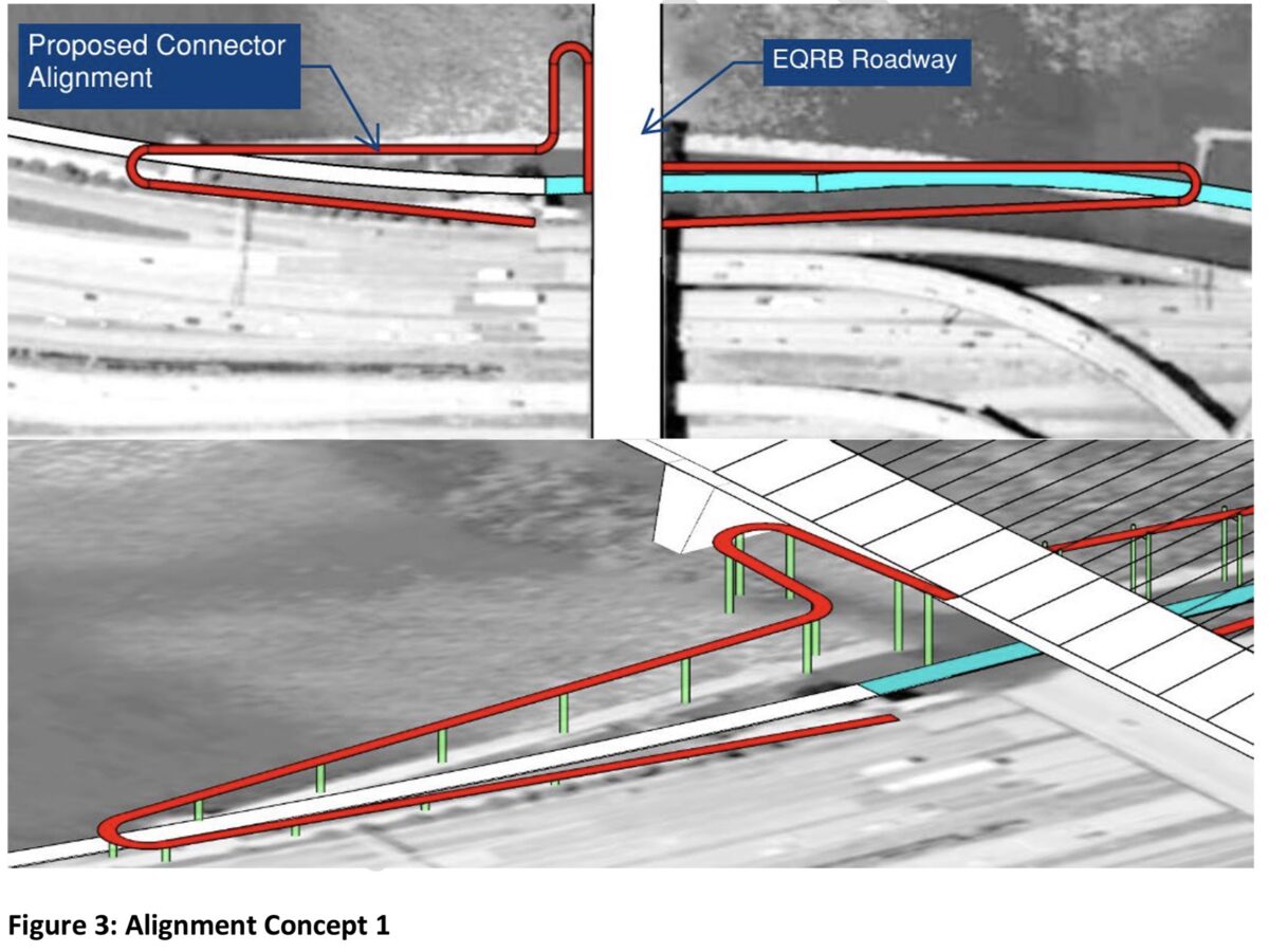
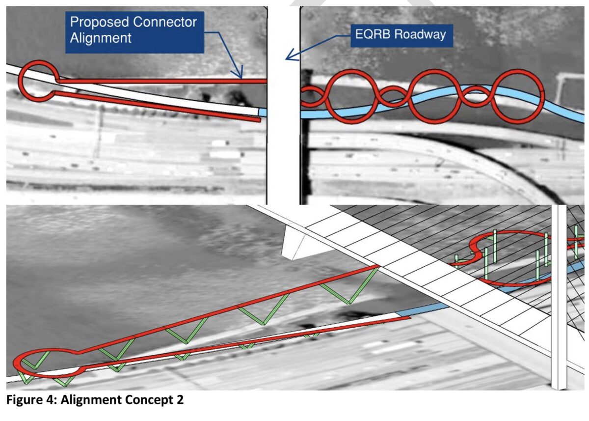
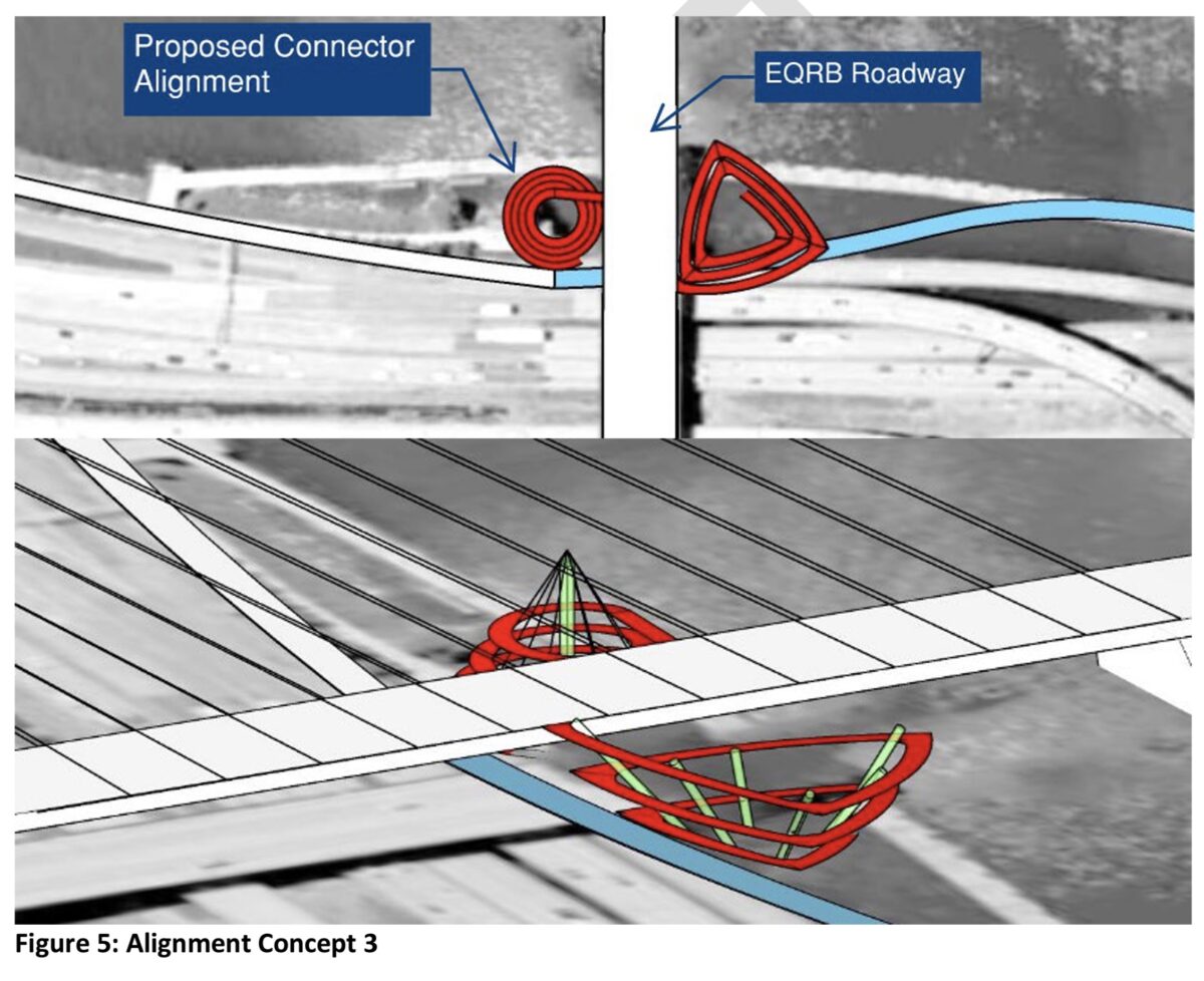
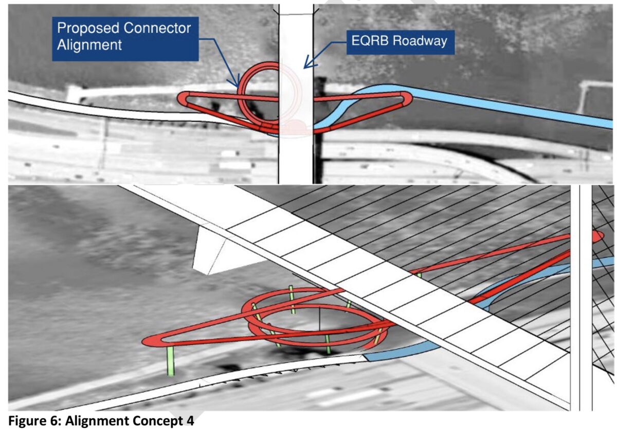
Here are the four options PBOT studied:
Alignment Concept 1 This concept provides a direct path from the bridge along the riverbank to connect the bridge to the esplanade. It also demonstrates the scale of the length of connector pathway required to meet ADA limits on deck slope. Two options for this direct approach are shown in Figure 3 below.
Alignment Concept 2 This approach uses meanders to gain travel distance within a more compact footprint while providing a more enjoyable experience. It also provides opportunities to slow bicycles and skateboards through the use of curves and out-of-path travel features. Two options for this approach are shown in Figure 4 below.
Alignment Concept 3 This approach provides a compact footprint with tightly radiused alignments to limit bicycle and skateboard speeds and reduce foundation footprint. Widened sections would also be included for resting/refuge. Two options for this approach are shown in Figure 5.
Alignment Concept 4 This concept incorporates an asymmetric structure that provides access from both the north and south sides of the bridge walkways and merges them under the bridge to touch down at the esplanade on a single walkway. This section could be flipped to place the helix on the north side so less structure is constructed within the zone of highly liquefiable soils.
A fifth option is a larger park concept put forward by nonprofit Human Access Project.
The final ramp design will be decided later, but because PBOT passed the amended LPA language today that includes, “as a condition of approval, the EQRB [Earthquake Ready Burnside Bridge] program shall provide for an ADA accessible ramp connection to the Eastbank Esplanade from both the north and south side of the EQRB,” the stair/elevator option is even more unlikely to be built.
“The City of Portland resolution is not legally-binding, but Multnomah County is committed to collaborating with the City-led ramp project in the Final Design Phase,” said Earthquake Ready Burnside Bridge Project Manager, Megan Neill in an email to BikePortland after the vote. “Multnomah County is preserving the existing City of Portland owned staircase that’s already in place. Multnomah County is not precluding the City of Portland from connecting a ramp to the bridge in the future.”
A big sticking point will be who pays for it. PBOT estimates the ramp will cost about $90 million (and HAP’s concept could be as much as $149 million).
One big reason that Hardesty and the rest of council were able to pull this off is because of the work of a coalition of advocates. Human Access Project, The Street Trust, Disability Rights Oregon, and Bike Loud PDX were among the groups who wrote letters of support and testified in support of a ramp today’s meeting.
“We’re very excited that there will be an opportunity to have ramps as opposed to an elevator,” Kiel Johnson with Bike Loud testified. And Serenity Ebert said, “As a disabled cyclist, I believe a ramp is the superior choice. An elevator cannot be relied upon for reliable access.”
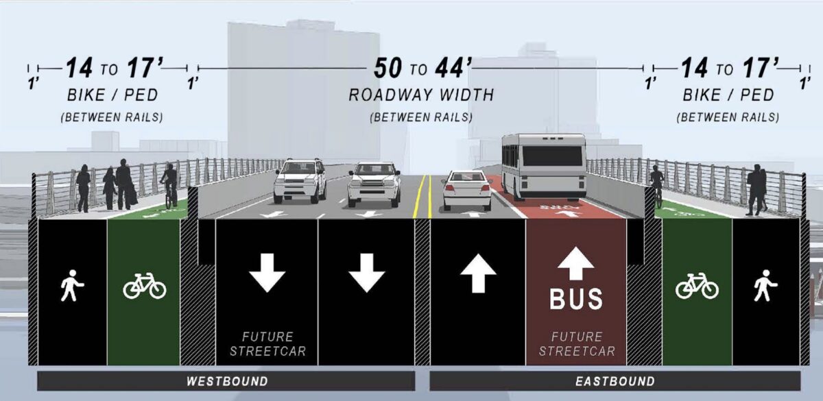
As for lane cross-section on the bridge deck, the County’s latest concept says the width of the bicycling and walking lanes on both sides of the bridge would vary from 14 to 17-feet. But the resolution adopted by council today said the County must provide a minimum of 17-feet. PBOT, who holds authority on the lane configuration question even though the County owns the bridge, also said they support a 10-foot wide inside general purpose lane — that’s narrower than the 11-foot width the County had recommended.
From here, the project goes into the design phase where final details will be hammered out. Multnomah County says they expect construction to start in 2025.
CORRECTION 7/21: This story originally said the County must have the City’s LPA endorsement for the project to move into the next phase of the NEPA process. That is not true. It’s a common/best practice, but not a requirement. We also stated that the County must scrap the stair/elevator option as a result of the City’s resolution. That is also not the case. We regret the errors.



Thanks for reading.
BikePortland has served this community with independent community journalism since 2005. We rely on subscriptions from readers like you to survive. Your financial support is vital in keeping this valuable resource alive and well.
Please subscribe today to strengthen and expand our work.
Good to see PBOT pushing back against MultCo, which seems to be the most regressive transportation agency of all (certainly worse than PBOT, WashCo, and ODOT). Their county roads like Skyline, Corbett Hill Road, Germantown Road, and the like are consistently horrible for people biking and walking, and there seems to be no appetite at all to fix it.
People like to hate on ODOT and PBOT, but MultCo for some reason seems to get no attention despite being much worse.
Thank you for covering the meeting today, Jonathan.
This is great news. Ramps should be the standard going forward given the recurring failures and unwelcoming nature of staircase/elevator projects like the Bob Stacy and Darlene Hooley Crossings.
Glad that wise decisions are being made and Burnside can become a practical option for cycling.
I never forget that billions (after cost overruns) are about to be spent on “auxiliary lanes” nearby, so no reason net new capacity for cycling shouldn’t be at least equally important.
Elevators simply are impractical for so many reasons. Capacity and reliability being obvious. Sadly, they are also dirty and dangerous in our current environment. Thinking they are a viable option is almost an insult.
I’m glad they are studying the ramp, but those options are fair to terrible. The ramp should go straight north-south, no loops or turns. The total length will be the same, and it can be much cheaper if they go along the shore instead of over the river.
Specifically, they should remove the ramps from I5 to the Morrison bridge and use that space for the bike ramp down from the Burnside to the Esplanade. It would be good studying if only one side can be ADA grades for pedestrians, while the other could be a 6% grade (highway grade) for bikes.
I personally would enjoy a ramp there — the stairs are awkward with a bike and Morrison is a nice bridge as well a a good crossing point.
But this would be lightly used even if it would logically increase active transportation on the bridge. Even on a great day like today or yesterday, there was hardly anyone on the Esplanade when I passed through between 5 and 6pm.
Seems like that kind of dough could deliver far greater impact/benefit spread across multiple projects elsewhere.
Maybe there would be more if there weren’t so few safe & convenient ways to access the Esplanade from the street.
Great to see that progress is being made. The city needs this.
This is great. No more elevators! Also, no corkscrews.
$90 – $149 million for a bike/ped ramp. Granted, there are plenty of challenges in this application, but that is A LOT of money. Trying to figure out the budget without taking a lighter to bundles of 20’s …
I do hope they use a local contractor so that some of that money stays in the region.
It’s not a lot of money when compared to the cost of widening a short section of I-5 through the Rose Quarter or what they’ve blown simply planning for the CRC/IBR.
Here’s a better idea: No ramp, no connection.
Consider the four turning motions the ramp would facilitate, and compare with existing alternatives:
$90 million is an absurd amount of money to spend on a ramp that simply duplicates turning motions that are already well served by alternative routes. For reference, Ned Flanders crossing cost $6 million. The Blumenauer bridge cost $13 million. The entirety of Central City in Motion is budgeted at $72 million.
Furthermore, with 1/4 mile long switchbacks, the route becomes significantly worse than alternatives. Big Pink to Esplanade/SE Salmon is 1.1 miles via the Morrison bridge. The Burnside-Ramp-Esplanade route would be 1.35 miles. It’s worse going north. Big Pink to the Moda Center is 1.1 miles via the Steel bridge. The Burnside-Ramp-Esplanade route would be 1.5 miles.
It’s not unreasonable to push for quality infrastructure for these turn motions. But the ramp is probably the worst way to accommodate them, both in terms of budget and added trip length. Investments should focus on improving the existing connections instead.