“I am very worried that by being timid, the county risks ending up with a new bridge that won’t meet the needs of the coming century.”
— Andrew Holtz, Multnomah County Bicycle and Pedestrian Advisory Committee
As cities across the Pacific Northwest grapple with the possibility of a devastating earthquake that current infrastructure is largely unprepared for, a crucial project underway in Portland is the Earthquake Ready Burnside Bridge.
According to Multnomah County’s Draft Environmental Impact Statement for the project, most of the bridges in Portland crossing the Willamette River are expected to be unusable immediately after an earthquake. Though bridges like the Tilikum Crossing and the new Sellwood Bridge are expected to survive an earthquake, neither of them will suffice. Neither the west nor east approach to Tilikum Crossing is seismically resilient, and the new Sellwood Bridge is too far from downtown.
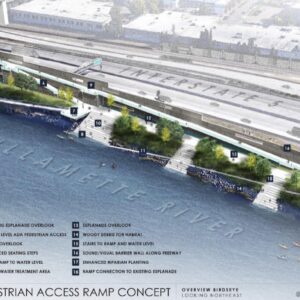
Plans to construct a new Burnside Bridge have been underway for several years, and many stakeholders have seen the new project as an opportunity not only to prepare the region for a possible earthquake, but to also improve Portland’s bike and pedestrian infrastructure, as well as potentially add a new park along the Eastbank Esplanade.
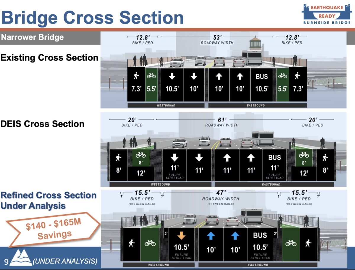
The Earthquake Ready Burnside Bridge project was initially expected to cost more than $800 million, and included 40-feet of biking and walking space, as well as a ramp from the Esplanade up to the bridge deck. But starting in June, Multnomah County officials began to appear more hesitant to spend so much on this project, and have been weighing options for cost-cutting measures that would sacrifice space for biking and eliminate the Esplanade ramp. Since the pandemic, officials say the price of the bridge project has risen to about $1 billion due to inflation. With the failure of last year’s Ballot Measure 26-218, the county is looking to cut costs wherever possible.
Advertisement
These proposals for cost-cutting have been met with concern by advocates for car-alternative transportation. Last Wednesday, the Multnomah County Bicycle and Pedestrian Advisory Committee approved a letter to the county to reconsider narrowing the bike and pedestrian paths and to commit to a ramp that would make the bridge accessible to all — without having to rely on elevators which are very prone to being out of order for large periods of time.
The letter brings up three main points of concern: that a narrowed bridge will fail to meet emergency response, rebuilding and personal transportation needs immediately following a major earthquake; that failing to make specific and firm commitments to pedestrian, bicycle and other wheeled transportation infrastructure “squanders the opportunity to lead the way toward safer and convenient active transportation in our region” and that these shortcomings put the county’s adopted Climate Action Plan at risk.
For more than two years, climate activists have been concerned about how the new Burnside Bridge plan focuses on drivers even more than the current bridge does. At a PBOT Bicycle Advisory Committee meeting in September 2019, members brought up their concerns about how a plan to expand auto lanes fails to consider the urgent need to take drastic measures to curb the climate emergency. That concern is still very present today.
“The new Burnside Bridge is the largest infrastructure investment the County has made in our lifetimes. It must be a bridge that will help us meet the challenge of the climate crisis. When weighing project budget options, we must not undercut progress toward reducing vehicle emissions,” the recent letter from the MCBPAC reads. “That necessity includes incorporating future expansion of bus and streetcar transit on the Burnside Bridge. The County must ensure that the design of the Earthquake Ready Burnside Bridge fully aligns with the County’s Climate Action Plan.”
The MCBPAC letter also points out that after a major earthquake, people will be unlikely to be able to fuel their cars with gas or electricity — even if there are still drivable routes intact. Biking and walking will be the most practical forms of personal transportation, so an earthquake ready Burnside Bridge needs to prioritize these methods of transportation.
“I am very worried that by being timid, the county risks ending up with a new bridge that won’t meet the needs of the coming century plus. This project…is a test of whether the county is actually committed to its 2015 Climate Action Plan. The cost-cutting proposals indicate they are not fully committed to making investments that will help reduce motor vehicle emissions, in part by encouraging people to shift to walking, biking and transit,” MCBPAC Chair Andrew Holtz wrote in an email to BikePortland.
Even if many details of the bridge are still up in the air, Holtz says he fears what is proposed now will set the tone for future planning.
“I am concerned that what is put forward now will become the high-water mark. If we don’t get firm commitments now to path width, transit lanes, and ramps and paths that offer safe and convenient connections to the Eastbank Esplanade, I’m afraid that what actually gets built could be woefully inadequate,” Holtz writes.
If you want to weigh in, please submit a public comment on the proposed budget cuts by the end of the day today, December 14.
CORRECTION, 3:48 pm: This story initially claimed that the new Burnside Bridge would be the only Willamette River bridge that can withstand a major quake in the Portland area. That is not true. We regret the error.


Thanks for reading.
BikePortland has served this community with independent community journalism since 2005. We rely on subscriptions from readers like you to survive. Your financial support is vital in keeping this valuable resource alive and well.
Please subscribe today to strengthen and expand our work.
“Currently, there are no bridges in Portland that would be safe to cross in the event of an earthquake”
Not even the Tilikum? It was completed in 2016 and can carry rubber-tired vehicles. Presumably it wouldn’t be opened to general vehicle traffic in an emergency but police/fire/medical/disaster-response could use it (with flaggers to ensure safety if light-rail operations continue).
Good point, and what about the Sellwood? Did they not consider earthquakes when it was built less than 10 years ago?
Sellwood bridge, too, I think. But I think there is some question about the integrity of the approaches to both of those bridges if a magnitude 9+ was to hit.
Or the sellwood bridge which was recently built? I have to believe they made it as earthquake resistant as the technology and engineering allowed
And the Sellwood Bridge was finished a year or so later? I don’t think they were designed to be “earthquake proof” or whatever the terminology is, but they were at least built to current seismic standards. I think Burnside is being held to a higher standard because there are not overpasses on either side and it’s designated as a lifeline route in the event of a natural disaster like an earthquake.
And the Sauvie Island Bridge.
Hi Bob, thanks for pointing this out. This was definitely an incorrect statement on my end — I meant to say that there are limited options for crossing the Willamette in the case of an earthquake, and having a resilient Burnside Bridge will be crucial in this situation. More detailed correction to come, but my apologies for that mistake there.
Thanks for updating the article – the information about the approaches to the Tilikum and others is good to know. I’m now curious about Moody Ave. – its route was essentially built on ~15ft of fill.
That’s my understanding of the Tilikum. The bridge will survive, but the approach roadways may not. I can’t find a reference quickly though.
My understanding from hearing a previous presentation to the East Portland LUTC, it’s not necessarily the bridges over the river that will collapse, but the approaches and onramps that are not up to standard, as well as large built-up areas that will liquefy near the roadways. A lot of city and state roadways are built on top of hidden viaduct bridges over even more hidden swamps, bogs, and soft soils that still exist under concrete near the river or even up to a half-mile from it.
The Tilikum and Sellwood spans are designed to withstand a major quake, but landslides and subsidence may block or undermine the approaches, leaving the bridges inaccessible for a while. The goal of the Burnside Bridge project is to have it open within hours. And related projects are looking at strengthening other points along Burnside, so that the route can be used for evacuation and emergency services and supplies.
If cost is such a big issue, why not just replace the Burnside bridge with a copy of the tilikum crossing? Even if accounting for inflation, that would be a quarter of the projected cost of the Burnside bridge replacement. Build for bike, ped, transit, and disaster resilience first. If there’s any money left over, then consider adding some capacity for private motor vehicles.
Why are they replacing the Burnside and not the Steel Bridge? The Steel Bridge caries train and MAX
I think the reasoning is that Burnside is a major arterial that spans the county from east to west. Plus, steel bridge is owned by the union Pacific railroad.
The Steel Bridge is owned and maintained by Union Pacific RR, and not Multnomah County.
East/West rail connections will not be critical in a major earthquake. Getting rail supplies to the region would be helpful, but there are many other locations along the BNSF and UP lines that would be completely destroyed (massive landslides in the Columbia Gorge and along the BSNF main between Portland and Seattle). The Steel bridge is useful for moving trains through Portland, but is not required to move materials in or out of Portland.
Additionally, the Steel Bridge would be a very difficult span to rebuild in a way that it could survive a megathrust quake. The rail line has to cross just above river level, so a lift span must be used. Since you have MAX and vehicles on the upper level, that rules out bascule lift and swing spans. Counterweight lift spans are not going to survive the big one. We should be working to move MAX into a tunnel downtown, which would eliminate this issue, freeing up Union Pacific to rebuild it with a bascule lift.
thanks!
The long term solution for seismic resiliency of the MAX, as well as capacity, is a tunnel from Goose Hollow to the Lloyd. Had the regional transportation measure passed there would have been at least planning money for that, but it didn’t and AFAIK nothing is happening with that idea right now.
great observation!
The gist of the article pretty much sums it up. Inflation and lack of funding will stall plans for bridge replacement/retrofit. Taxpayers are already saying no to paying for it. Let Natural Selection do its job.