Portland Parks & Recreation has closed one of the two sets of ramps on the Eastbank Esplanade until further notice.
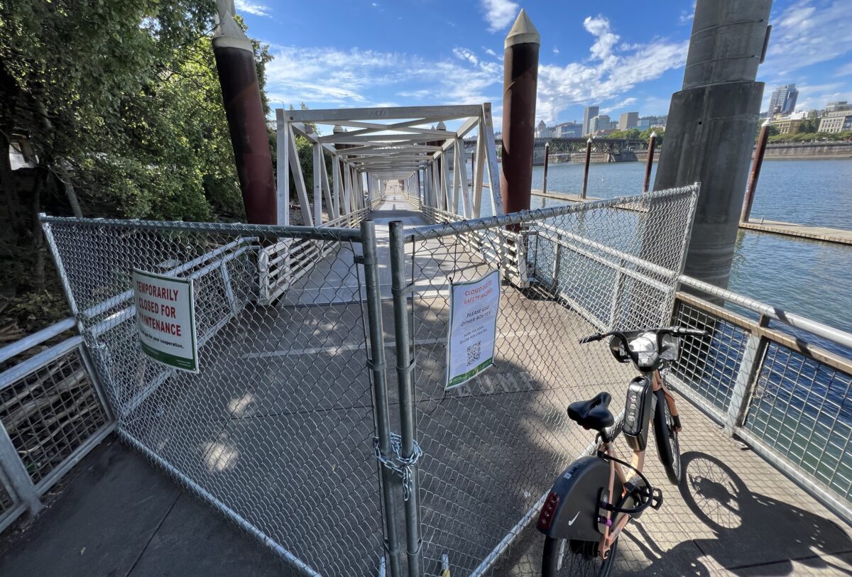
People using the path today were given no prior warning before coming to chain-link fence and sign announcing the closure. A QR code on the sign links to a page on Parks’ website that says, “Due to a safety hazard, related to low water levels in the river, there is currently no northbound or southbound access along the Eastbank Esplanade (between the Steel Bridge and the Burnside Bridge). Please use an alternate route.”
This is the ramp just south of the Duckworth Dock. That dock is still open, you just have to access it from the south.
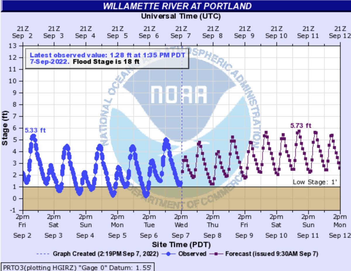
According to the National Weather Service, the current stage of the river (measured at the nearby Morrison Bridge) as of 1:30 pm today (Wednesday) is 1.28 feet. The NWS defines “Low” stage as 1.0 feet. The previous three days of this week, the river had been even lower, reaching a stage near 0 feet just yesterday. That level was among the top 20 or so lowest ever recorded by the NWS.
The forecast (right) shows water levels will increase steadily over the next few days.
Just three months ago, this same section of the Esplanade closed due to high water levels.
The ramps on the Esplanade between the Steel and Burnside float on the river, so Parks must monitor them to make sure the inclines and declines are within a safe range for all users.
Keep this closure in mind when you plan your route. The best detour is to either head over to the west side of the river via the Steel Bridge path or stay on the surface streets through the Central Eastside.
UPDATE, 3:53 pm: A reader says they were on their morning commute Tuesday morning when they saw police activity and a dead body at the end of the Duckworth Dock. By that afternoon the closure had gone up. We have not confirmed this with Parks yet.


Thanks for reading.
BikePortland has served this community with independent community journalism since 2005. We rely on subscriptions from readers like you to survive. Your financial support is vital in keeping this valuable resource alive and well.
Please subscribe today to strengthen and expand our work.
I sent an email to PP&R expressing my displeasure at the absolute lack of signage. Its reasonable to close the bridge, but they simply need signs beforehand at the top of the ramps at interstate, end of the steel bridge, at the Burnside stairs, and at the Belmont ramp (for those unable to go up the Burnside stairs).
Its just unbelievable that early detour warnings aren’t part of the thought process here. I’ve compared it to closing a tunnel on Cornell with no early warning. Can you imagine the uproar from drivers?
Can you share the PPR email address? I would like to do the same. I got there today around 5:30 pm and it was still closed, with no signage. I had to go back all the way to Morris because I rode a cargo bike, which was quite annoying.
https://www.portland.gov/parks
Thanks! I just sent an email.
It’s cut by a vigilante your free
It’s like when they close the sidewalk at one end, but don’t warn you about it until the middle. When are you can do is step off the curb into traffic turn around.
My first handful of crossings of this section were rather disorienting due to ramp slope changes before my Homer-esque realization that it was floating. I would be curious to know the slope limits, and how the structure is limited should they be in excess, as we’re seeing nearly 6 feet of vertical water level change in September alone.
An aside, you mentioned the path being open while levels were lower. I’ve found often these sorts of issues require 3rd party notice and reporting, resources to measure are likely limited and would probably need onsite verification prior to closure. Although we often assure ourselves that “there must be someone in charge of that” if we make an observation and can spare the bandwidth, it never hurts to ‘raise a flag’ and verify that some official is aware of the apparent discrepancy.
Less than 3 months ago this was closed due to too *high* water. This must be a new record for shortest time between too high and too low closures.
It’s typical of COP to provide no advance warning of anything.
Many things. They do *sometimes* provide advance warning.
Oh no is our beloved Willamette River starting to dry up too?
No. We’re nearing the end of the water year (Sept 30). Statistically that’s when water levels are lowest across all of the west. Our climate in the PNW is characterized as having mild but dry summers. Lower levels in the Willamette right now are to be expected. Similarly, its highest levels are expected towards the end of spring (i.e., 3 months ago) when there’s still rain falling in the valley and snow is melting in the high country.
Encountered that on Tuesday morning with zero warning and zero dignity granted to the person laying dead at the end of the dock. It was a horrific and deeply upsetting scene and it’s wild to me that the path wasn’t closed while PPB cleaned it up.
When was this? I biked up to the fence on Tuesday morning at 6:30 am.
I got this response from PP&R: “I have staff placing the attached signs (8X10 laminated) throughout the Esplanade today. I am working with our Outreach team and PRMS to have larger signs added soon.”
If this is steepness/ADA issue, PP&R should leave teh ramps open and provide warning signs that the grade is too steep. This is totally allowable- they are not required to block access to all users because of a natural event. People in motorized mobility devices (the vast majority of people using mobility devices) would have no problem navigating this slightly increased grade if they were properly informed.
From my understanding, this is not an ADA/Steepness issues. If it were, the southern ramp would be closed as well.
My take is that the lowest ramp float was either grounded during the low tide and/or was obstructed by debris during the low tide. I heard from a friend at the City, that this situation caused an abrupt lip between the ramp and floating walkway that cause a serious injury on Tuesday.
Since this is an important link for the regional [bike highway] route for Portland (aka “Bike Town”), did PP&R file a detour route and coordinate this with PBoT, so that supplemental signage and bike lanes could be installed…as this is a seasonal [aka predictive] event and thus does not really fall under the ’emergency’ classification allowances for unexpected detours (like a water main break, etc.).
Then we can dip into the federal requirements for ADA route closures too…if you have the time…
I think we’re entitled to a detailed and clear explanation for the closure.I agree with D2, above, that closing this route I a very big deal for bike riders and probably some pedestrians comparable to closing a major tunnel for drivers. AND better signage and suggested detours (of which there were none when I was there today.) People who wrote other comments, above, are guessing why the low river level required a closure, but we should be told. Is this something that can be fixed? If not, we’re probably going to see extended closures every year from now on, which is awful. So it HAS to be fixed or a reliable alternative must be found.
It’s going to be very darkly comical to see this monument to climate crisis hypernormalization become increasingly non-functional.
Today 9-13-22 on my way home I forgot it was under “maintenance” is what the sign said, to my amusement someone cut out the fence so you can go right on by.