Southwest Barbur Blvd, which runs from south of SW Capitol Highway to SW Naito Parkway downtown, is one of the main routes from southwest Portland to the rest of the city. It’s also a notoriously dangerous place for people walking and biking.
“We in the community doubt [the project] will improve safety for people walking and biking in the West Portland Town Center.”
— Marianne Fitzgerald, southwest Portland resident
Earlier this month, the Portland Bureau of Transportation passed an ordinance to authorize their share of funding for the Barbur Crossroads Safety Project, an Oregon Department of Transportation project that aims to make it safer for people who walk and bike to navigate a massive jumble of stressful arterials and destinations known as West Portland Town Center. But activists are skeptical this project will garner needed safety benefits.
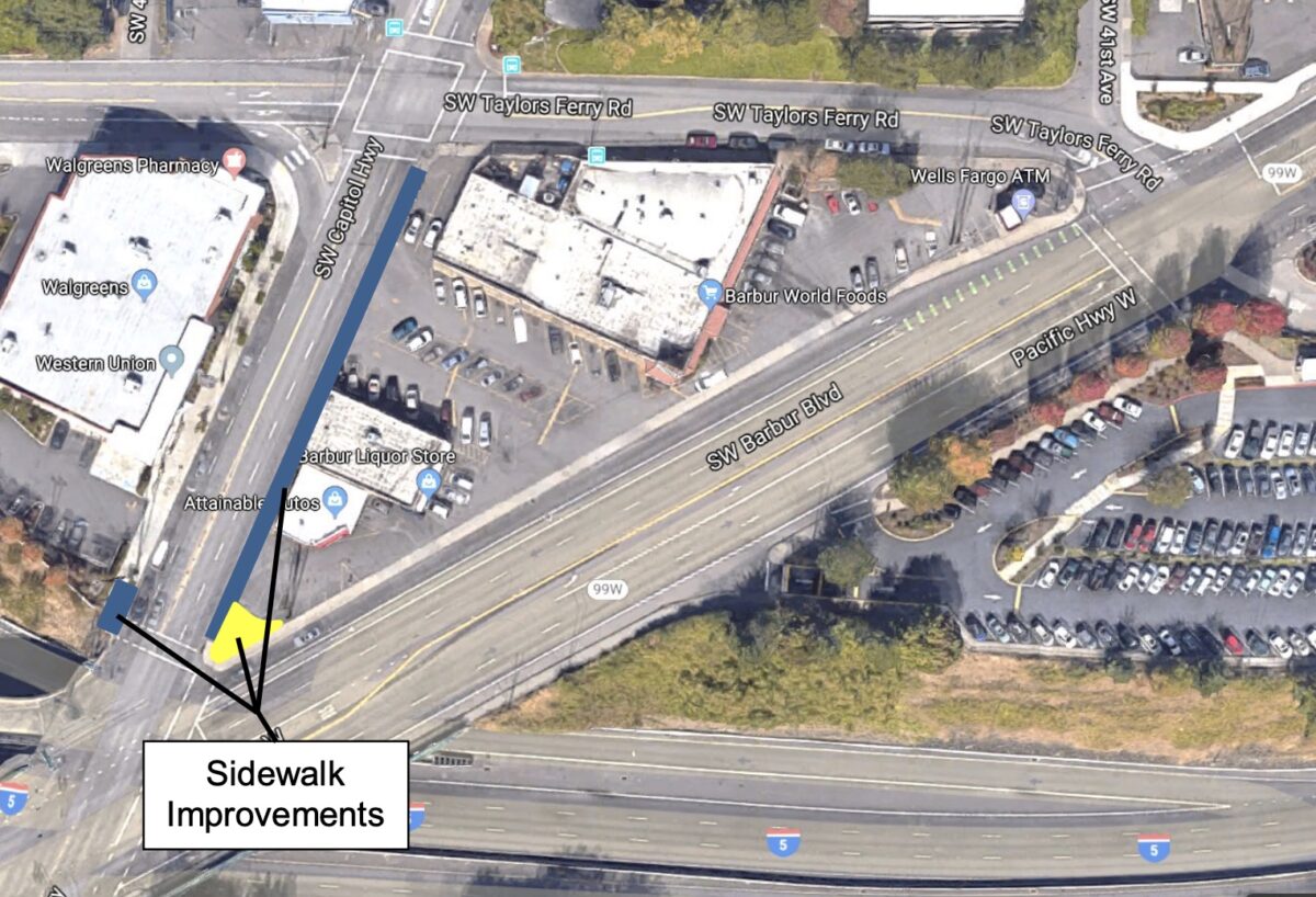
Back in June we reported that PBOT would work with ODOT to build a bikeway for people riding across Barbur and Taylors Ferry Road on SW Capitol Highway (where it crosses I-5, see above).
Since PBOT is already undertaking a major project on SW Capitol Highway, it wasn’t clear how PBOT and ODOT would work together at the intersection because of project scope boundaries and overlapping jurisdictions.
PBOT’s ordinance finally provides some clarity.
Advertisement
Through this ordinance, PBOT has agreed to provide $209,000 in local funding to “construct pedestrian improvements” on SW Capitol Highway. This money will come from the Fixing Our Streets ten-cent gas tax and Transportation System Development Charges (TSDCs), which are fees levied on business owners to maintain roads that support their buildings.
According to PBOT, ODOT has hired a contractor to construct a concrete sidewalk and bikeway along the east side of SW Capitol Highway between SW Barbur Boulevard and SW Taylors Ferry Road at its request. This will be a shared-use path. There will also be a pedestrian plaza at the northeast corner of SW Capitol Highway and SW Barbur.
PBOT says that this project “increases space and comfort for people waiting to cross SW Barbur Boulevard on foot or mobility device and provides designated routing for cyclists through the project area.”
According to some local activists, however, this plan won’t be enough. Marianne Fitzgerald, a southwest Portland resident who has been involved in transportation reform in the area for decades, submitted testimony on the ordinance that stated: “We in the community doubt [the project] will improve safety for people walking and biking in the West Portland Town Center” and that “PBOT’s portion of the project is window dressing to mitigate ODOT’s project that changes motor vehicle traffic circulation and adds a motor vehicle travel lane in a way that will place more people in harm’s way and impede access to the Barbur World Foods grocery store.”
Fitzgerald asked PBOT to amend this ordinance and add a directive to “monitor the safety data in the vicinity of this project and report to the community on an annual basis.”
“If the safety of pedestrians and bicyclists becomes more compromised, or if access to the Barbur World Foods grocery is impeded, PBOT shall work with ODOT to re- evaluate the project and determine immediate and long term solutions that will make it safer to walk and bike within the West Portland Town Center and access the grocery store,” Fitzgerald wrote.
Fitzgerald is concerned that the jughandle redirection of traffic in the BCSP will put people walking and biking in danger and is asking for a specific confirmation from ODOT and PBOT that they will make changes if this is the case.
PBOT Interim Communications Director Hannah Schafer says that the transportation bureau hasn’t found that the new traffic routing will cause safety problems. She says that even if it’s not stated outright in the ordinance (as Fitzgerald requested), PBOT already plans to monitor traffic data with a safety lens as they do with all projects.
Unfortunately neither PBOT or ODOT has a plan for how to create safe cycling space on SW Capitol Hwy between Barbur and SW Huber (south of the location covered by this ordinance).
As we said in an article in June, this area is likely to remain a high-stress, car-centric environment regardless of the bike facilities that are included. Some form of bike passage is better than none, but there will need to be more substantive changes made for people to truly feel safe walking or biking through the Crossroads.


Thanks for reading.
BikePortland has served this community with independent community journalism since 2005. We rely on subscriptions from readers like you to survive. Your financial support is vital in keeping this valuable resource alive and well.
Please subscribe today to strengthen and expand our work.
In the image, the north-pointing orientation arrow is actually pointing east.
Yeah that was my fault. Sorry. Uploaded a new version.
That’s a great project. They should also separate the parking lots so that people don’t drive on the sidewalk to try to get to different streets and avoid the stoplights. I almost got backed into by a car while I was walking from Barbur World Foods on the sidewalk to that intersection. He stopped to apologize when he saw I was carrying a baby, but he swears he looked and just didn’t see me, which struck me as just bad looking since I’m over six foot and it was in the middle of a sunny afternoon.
PBOT’s ordinance exhibit is directionally challenged. But that’s not why I’m here.
I’m here commenting because I live one mile west of this intersection/interchange area and I ride through here sometimes once, sometimes twice per day to get my daughter to and from pre-school (on an e-bike). This area is by far the most challenging and nerve-wracking part of our 7-mile round trip ride. ODOT’s ‘improvement’ project fails to adequately address the needs of pedestrians and cyclists and is incredibly short-sighted within the context of the West Portland Town Center plan objectives and the current PBOT project on Capitol Highway.
Without dedicated cycling infrastructure on Capitol Highway and Taylor’s Ferry, people are forced to ride in mixed traffic in an area with high traffic volumes and many potential conflict points. Sure, the project eliminates a left-turn conflict on Barbur/Capitol, but it does nothing to address the needs of people traveling by bike on Capitol or Taylor’s Ferry (the only two roads in and out of here) and it likely makes conditions for bicycling worse.
It worsens conditions in two ways – first, it routes more auto traffic onto these two roads (jughandle) and second, it adds another auto travel lane on Taylor’s Ferry (dedicated right turn onto Barbur) without a place/space for people on bikes trying to get to NB Barbur and/or the Barbur Transit Center.
Similar to the I-5 Rose Quarter project, I can’t help but wonder why there isn’t a stronger case being made to simply close some of our Portland-area I-5 interchanges to address ODOT’s freeway congestion, merging, and safety issues. Curious what others think.
I likewise live in this area, years ago rode up Taylor’s Ferry thru this intersection and onto Barbur every day while commuting to school. Just like with the SW Corridor project, they completely punted on the opportunity for reduction in scope of the whole interchange, because it’s “too complicated” or whatever. It’s still based on this ruthless pursuit of “efficiency” while maintaining the same traffic volumes. The interchanges here are horribly designed and you’re right–it won’t ever be safer unless Barbur got road dieted with light rail continuing smack down the middle and perhaps getting rid of the on and off-ramps in their entirety. But we know that’s not happening now. Frustrating to say the least, “least disruptive” planning tendencies taking precedent over true safety improvements.
Yes, I was so looking forward to the Max line project, which would have fixed so many of the bike/pedestrian problems. Plan B needs to come quickly.
If I remember correctly, SW Corridor max line was to run elevated over this intersection, thus avoiding it, and not fixing the problem. Same thing up north, the MAX was to flyover I-405 and the area surface streets. When the going got tough, the train flew over the surface street problems.
I just looked at the plan and you are 100% correct! While it wouldn’t fix that particular intersection, it would have definitely given people more ways to safely move around this part of Portland, especially for those of us living South of I-5/Barbur.
Looking at the plan again, the proposed sidewalks and bike lanes on parts of Taylors Ferry, Pomona, SW 26th Ave, and the many other places that are currently crummy to bike/walk would have been amazing, just to name a few.
While they punted on that tough intersection, there’s tons of low-hanging fruit, and every little bit helps!
This intersection is near and (un)dear to my heart – I have to negotiate it when commuting from PCC Sylvania to Multnomah Village, in the dark. Any PBOT/ODOT improvements would be welcome.
Why does twitter identify this as the SE PCC campus?
Hi Bryan,
Because I shared the wrong link with the tweet! Here’s the story you are looking for.
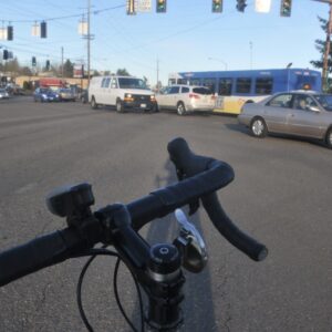
There’s only way to ride your bike thru this car-centric hellscape: Put your arm out to signal your intention to take the lane, look over your shoulder to ensure you have room, and then pedal like hell. Of course this strategy works for only more confident cyclists – I wouldn’t allow my eight-year-old kid to navigate this intersection on his own.
The so-called improvements sound like window dressing. A “pedestrian plaza” on the NE corner?? What good does that do? – a place to stand and look at a potted plant while the cars and trucks whiz past?
The shared bike-ped lane next to the (terrible) liquor store sounds like it’s going to run next to the dedicated right-turn lane, where harried drivers will be rushing to turn right, right, and right again to complete the jug-handle and get onto I-5 south. Will bikes need to stop and wait for a signaled crossing, where the cars will have priority? I’m guessing that will be the case.
This entire part of town needs a do-over. There’s no way to fit what’s needed into the current footprint while allowing historic auto-throughput. That’s the unstated goal of every ODOT project: keep the cars moving – all others must wait. Sounds like PBOT has signed onto ODOT’s priority on this case.
I’m looking at the article’s aerial view with the “improvements” labeled, and comparing it to what’s there, and I don’t see ANY improvement. At first I thought the “pedestrian plaza” was a curb extension. But all it is is changing some paving from asphalt to concrete and calling it a plaza. This woman is already standing on it:
https://www.google.com/maps/@45.4538564,-122.7208906,3a,75y,67.19h,64.87t/data=!3m6!1e1!3m4!1s7sQ4hru6ixYvNQufGv4cEg!2e0!7i16384!8i8192
Same with the “sidewalk improvements” on Capitol Hwy. It looks like it’s not really much more than changing asphalt to concrete:
https://www.google.com/maps/@45.4540213,-122.7207573,3a,75y,50.23h,69.63t/data=!3m6!1e1!3m4!1sgSPaTHHK4mNPuIuwo1Sjsw!2e0!7i16384!8i8192
Meanwhile, a few yards away, this isn’t being touched by any improvements:
https://www.google.com/maps/@45.4541703,-122.7198766,3a,90y,12.41h,72.74t/data=!3m6!1e1!3m4!1s2F7URLKgUfZXOxJfxXb30A!2e0!7i16384!8i8192
Maybe there should a law that projects like this should be required to submit the design for transportation design awards. Make PBOT and ODOT put this up against other bike/pedestrian projects from around the country and say why it’s praiseworthy.