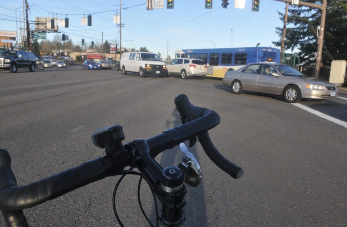
(Photo: Jonathan Maus/BikePortland)
“Now that the SW Corridor is not funded by the bond measure, are we just going to wait for it to be safe for kids to cross Barbur?”
— Eric Wilhelm, neighborhood transportation activist
For the past several years, much-needed changes to Southwest Barbur Boulevard have been linked to building the Southwest Corridor light rail line. When voters rejected Metro’s transportation funding measure in November, they also voted down financing for that project. TriMet now says the SW Corridor “is on hold.” Even if funding for the SW Corridor project happens as part of an infrastructure package under the Biden administration, it would take years to build.
So the question remains: How much longer will people who walk and roll on Barbur Boulevard have to wait for safety updates that have been badly needed for decades?
This article reviews Barbur’s safety problems with a focus on key intersections and projects in the southern half of the corridor from SW Bertha to Capitol Hwy. A second article will look at the corridor’s northern half.
Advertisement
Background
In 2013, as the Oregon Department of Transportation faced significant pressure to put Barbur on a road diet, BikePortland reported on the tension between advocates pushing for short-term changes while planners and bureaucrats wanted to wait for the longer-term light rail gravy train. “The SW Corridor plan is a visioning process that isn’t expected to result in concrete projects for 10-20 years (if ever),” we wrote. In that same article, veteran Southwest Portland advocate Keith Liden shared that because of its moderate grade and direct route, Barbur, “has enormous potential to be a primary bicycle route between downtown and southwest Portland.”
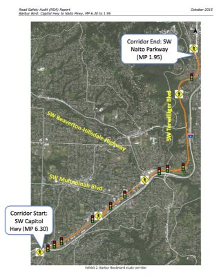
Barbur is one of Portland’s “orphan” highways under the ownership and jurisdiction of ODOT. In 2015, after much community pressure, and with political leadership from then state Rep. Ann Lininger, ODOT solicited an independent Road Safety Audit (RSA), which studied the 4.5 mile Barbur corridor from Naito Parkway to its intersection with SW Capitol Highway. The RSA noted that four other comprehensive studies had been completed in the five years previous to it, including Portland’s 2013 Barbur Concept Plan (2013), the PBOT Barbur High Crash Corridor Safety Plan (2012) ODOT’s Barbur/OR-99W Corridor Safety and Access to Transit project, and Metro’s Southwest Corridor Plan. Some recommendations from these plans have been implemented, including ADA ramps, a few pedestrian medians, improved bike facilities, and reconfigured crosswalks — but the need for larger capital investments remains.
Advertisement
30th Avenue and “The Diagonal”
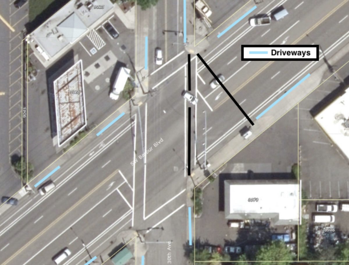
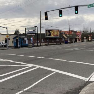
If this intersection looks familiar it’s because a man in a wheelchair was struck and killed here last month while rolling in the crosswalk.
I spent a bit of time on the corner of Barbur and 30th poking the crosswalk button, but I couldn’t bring myself to actually cross the street, 110 ft without a median felt too exposed to me.
Between the Fred Meyer at Bertha Blvd and the “Crossings” intersection at I-5 and Capitol Hwy, Barbur cuts diagonally through the area’s incomplete grid at a 40-degree angle. This diagonal creates a two-mile long series of irregular intersections, with the north-south streets intersecting Barbur at an acute angle, the east-west streets intersecting at an obtuse angle, and a couple streets making a jog to meet Barbur just right. Although each of these intersections is unsafe in its own way, the intersection with 30th Avenue will serve as a good example of problems common to all of them.
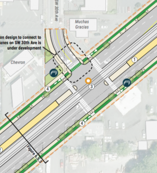
Any skewed street creates a crosswalk which is longer than the width of the street it crosses because the walk lies on the hypotenuse, rather than along the right angle, of a triangle. At 30th Ave., Barbur is about 80 ft wide, but its crosswalk is approximately 110 ft long—the street angle adds about 30 ft to the crosswalk length. In addition to the hazard of a long crosswalk, the turn angles exacerbate sloppy driving habits. Notice that the car turning left onto eastbound Barbur (in graphic above) is about to cut through the left turn lane. Similarly, a car turning right onto north 30th tends to make an early slice through the bike lane.
Advertisement
Good traffic control can improve safety at irregular intersections and the 2011 Barbur High Crash Corridor Safety Plan recommended that pedestrian countdown signal heads be installed at all Barbur signals. However, not only does the 30th Ave signal lack the recommended countdown, but the timing of the pedestrian crossing light surprised me. The crosswalk user gets 30 seconds total to cross Barbur: the “walk” signal lasts about four seconds, followed by a flashing red hand for about 24 seconds, and finally the flashing red turns to solid red for two seconds before Barbur cars get their green light. Nearly half a minute of a flashing “don’t walk” signal strikes me as inviting poor decisions. If the recommended countdown signal head had been in place at 30th Avenue, it might have prevented Clayton Chamberlin’s death.
“I really almost never venture to the 30th and Barbur intersection, this is a very dangerous intersection and I am not at all surprised that many accidents occur there.”
— Katherine Christiansen, Southwest Neighborhoods coalition
I spent a bit of time on the corner of Barbur and 30th poking the crosswalk button, but I couldn’t bring myself to actually cross the street, 110 ft without a median felt too exposed to me. It turns out I’m not alone. Katherine Christiansen, the chair of the Transportation Committee for the Southwest Neighborhoods coalition (SWNI), told me that she also avoids the intersection, “I really almost never venture to the 30th and Barbur intersection, this is a very dangerous intersection and I am not at all surprised that many accidents occur there.” She continued, “I see lots of pedestrians crossing Barbur to get to the bus stop just on the east side, it’s a popular stop and there are many public transportation users in the apartments nearby.” Katherine and I can choose not to cross the street, but it’s a choice some nearby residents don’t have.
A final hazard along the whole diagonal, one which is particularly bad near the intersection with 30th, is the density of driveways which punctuate the streetscape. 30th has over three times as many driveway related crashes as other locations, but the problem is bad all the way from 30th to the Crossings.
The Southwest Corridor Light Rail design would have cleaned up many of these problems and brought consistency to this disordered street segment. The plan was to purchase abutting private property and widen the Barbur cross section to include the train and platform in the middle, while maintaining two travel lanes as well as bike lanes, sidewalks and tree medians in each direction. At 30th, the width of the road, train and platform would have been about 100 ft.
But as southwest bike advocate Eric Wilhelm noted to me recently, “The SW Corridor at $300 million a mile makes the $20-plus million a mile Capitol Hwy project looks like quite a deal.”
The Barbur Crossroads Safety Project a.k.a. “The Jughandle”
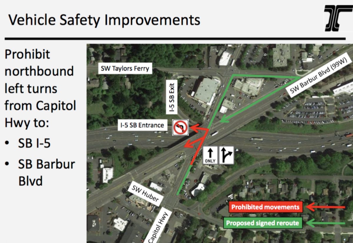
The Oregon Department of Transportation is planning one large project on Barbur, the $3 million Barbur Crossroads Safety Project, at the intersection of Barbur, Capitol Hwy and I-5. They plan to begin construction this year. The project would include “many safety elements including a new sidewalk, ADA ramps, pedestrian countdown signals, new illumination, new bicycle markings.”
At its heart, the project is a re-routing of northbound Capitol Highway drivers into a “jughandle” configuration for entry onto the southbound I-5 on-ramp. The jughandle would encircle one of the area’s most popular businesses, Barbur World Foods.
The re-routing is controversial. Many neighbors and transportation advocates prefer a protected left-turn lane and signal on the bridge, which would involve taking a northbound traffic lane. ODOT studied and rejected the protected left-turn option because, “the traffic analysis for this scenario showed a substantial increase in congestion on streets surrounding this intersection.”
Funding for the project comes from the All Road Transportation Safety program. ODOT notes there have been at least 161 crashes in the intersection since 2008 (all the three fatalities that occurred on Barbur in 2020 happened at other intersections).
Eric Wilhelm pointed out that the ODOT’s unwillingness to implement a lane diet will soon leave this segment as, “one of the last few blocks without a decent bikeway between PCC/Lake Oswego and Multnomah Village.”
According to PBOT, Portland had 17 deaths to people walking in 2020. Three of them, or one out of every 5.6, occurred on Barbur Blvd. With no train coming down the tracks any time soon, we must keep a focus on the need for safety updates on Barbur Blvd.
— Lisa Caballero, lisacaballero853@gmail.com
— Get our headlines delivered to your inbox.
— Support this independent community media outlet with a one-time contribution or monthly subscription.




Thanks for reading.
BikePortland has served this community with independent community journalism since 2005. We rely on subscriptions from readers like you to survive. Your financial support is vital in keeping this valuable resource alive and well.
Please subscribe today to strengthen and expand our work.
Thanks for the article Lisa! A few things to add to the conversation:
– The jughandle project in Crossroads is ODOT’s low-hanging-fruit solution from the Road Safety Audit that will make it worse for all modes of travel through the SW Barbur/SW Capitol Highway/I-5 intersection. Our neighborhood is advocating for a red light/speed camera similar to the one at SW 72nd and 99W in Tigard to deal with the root cause of the crashes. After a pedestrian was killed there in 2010 ODOT staff Sue Dagnese said there needs to be a study of all seven skewed intersections in Crossroads and how they affect each other, and that has never been done. The jughandle project will move the crashes from an ODOT street to a PBOT street, as has happened before. Safety will be even more compromised if ODOT implements tolling on I-5 at SW Multnomah Blvd. and more motor vehicles travel through Crossroads to avoid the tolls.
– ODOT and PBOT were working on jurisdictional transfer but I understand that, too, has been paused due to the failure of the Metro transportation measure.
– The Bureau of Planning and Sustainability is working on a West Portland Town Center Plan (the area surrounding Crossroads) that proposes rezoning the area around the Barbur Transit Center to accommodate high density infill while ignoring the traffic safety issues in Crossroads, except for some unfunded plans for plans for transportation safety improvements.
– The map shows the Road Safety Audit corridor but Barbur’s orphan highway continues to SW 65th. That area has become a homeless encampment like so many other ODOT rights of way. ODOT has “improved” the intersection of SW 64th and Barbur but it’s still lacking bike facilities.
Yes there are a lot of needs throughout the region. Unless the various bureaus and agencies build safe alternative transportation infrastructure in SW Portland and elsewhere, people will remain dependent on cars and we will never meet our climate goals.
So many needs, and so little money to go around…
Wealth tax. Traffic law enforcement with huge fines and vehicle confiscation.
And the problem is all thanks to Reagan’s tax cuts for the rich. What a despicable human he was.
Yup, and the Dems controlled the House during that entire time, and Joe was in the Senate back then too.
LOL still blaming a guy who hasn’t been in office since 1988?
…Yes? We’re still feeling the repercussions of his presidency today.
Like FDR’s Highway funding back in a time when so many used public transit and walking and biking.
Currently the city is buried in garbage and broken glass. That’s safe?
Garbage and broken glass don’t knock you out of your shoes.
A couple rides ago I accidentally ran over a discarded drug needle as I swerved to avoid another a pile of trash and had I not been wearing a high mountain bike shoe that covers my ankle I could have been stabbed. But you know, compassion.
Get Schwalbe tires. I don’t own their stock, or even like them because of their sluggish feel, but it’s the tire of choice for holding your line over road debris.
Yes, needles on the ground are a bad biohazard and not pretty. Three paragraphs about badly mistaken US drug policy omitted.
I ride my bike on Barbur every single day, so I feel uniquely qualified to comment.
The ODOT “jug-handle” solution is crazy – it’s just not gonna work. No motorist who is used to turning left from Capitol Hwy onto the I-5 on-ramp (the *only* I-5 South on-ramp between downtown Portland and Tigard, by the way) is going to cross Barbur, turn right on Taylors Ferry, wait in traffic to turn right again at the crazy angle onto Barbur, and then wait again to cross Capitol Hwy at the light and reach the on-ramp. To prohibit the left turn, ODOT will need to physically bar vehicles from making the left turn, and there’s no way to do that given the lack of space on the road.
What needs to happen is the Crossroads area needs to be completely rebuilt. It’s a relic of an earlier time, when traffic was lighter and there were fewer competing needs (no bikes or peds: it’s 1955 and everyone will drive since gas will last forever).
People who live in SW Portland and walk or cycle thru the Crossroads have a saying: “It’s so dangerous that it’s safe.” And that’s actually true for bikes: the lack of bike lanes makes it much safer b/c you have to get into the lane and the motorists have to acknowledge you and wait for you. It doesn’t work for kids or less-confident cyclists, but it’s the only workable solution til ODOT builds a bike-ped bridge of some kind to get us across Barbur and I-5.
Oh, the crosswalk across Barbur at the Crossroads is pretty dangerous, since cars come flying down Capitol and turn right fast onto Barbur at a shallow angle. I’ve almost been taken out there a couple of times while walking. It really needs a leading ped indicator to give peds a headstart, until that bike-ped overcrossing is built.
Thanks, Lisa, for pointing out the length of the crosswalks: I had always wondered why they seem so endless.
Burbur is a relic of the 1950s – there’s even that gorgeous vintage motel (https://www.yelp.com/biz/capitol-hill-motel-portland). It’s time to commit the millions of dollars needed to make it safe for the 21st century.
“It’s time to commit the millions of dollars needed to make it safe for the 21st century.”
That, in essence, is the rub. We all agree that fixing Barbur is a high priority, but where is this money coming from? And how much is actually needed? If you got $50 million, what improvements would you make? If you got $110 million (the amount for 4 miles of outer Powell), what would you do? $1.5 billion for the full meal deal is more or less impossible unless the feds are feeling particularly generous.
Or $100,000 and enough traffic cones and diverters to redirect traffic and/or close off sections of Barbur to through traffic, what would be your plan?
Right now the Oregon governor and legislature want to make a series of utterly useless improvements to I-5 and I-205, and moreover want to rebuild the I-5 Columbia Bridge (again). Metro voters rejected a bond package. And Portland won’t commit city funding for ODOT projects unless it is SDC funding for capacity expansions.
Of course even within SW, Barbur is competing with I-5, Capitol Highway, BH Highway, light rail, and so on; and citywide with poorer parts of town also in desperate need of improvements. And of course PBOT is making cuts this year.
How much would it cost? Well, the mile of Capitol Hwy south from here to PCC was restriped by PBOT with a lane diet and some flex posts for about $200k. Given that it is only 8 miles from Tigard to where PBOT’s jurisdiction takes over at Naito, and ODOT has $3M “for safety”… that comes to $375k per mile. It seems to me that this would be plenty for a similar tactical road diet: partially protected bike lanes and bus priority lanes on the existing paving. The audit found that traffic throughput is constrained by signals at both ends of the wooded section (and I’ve frequently caught up to drivers at the red lights going either direction, uphill via 20mph e-bike.)
I can only conclude that leadership at ODOT wants the road to stay deadly to discourage people from walking and biking, and perhaps it’s also staff because they see their jobs as being funded by gas tax revenue. As they were preparing the RSA response, I was told that they would not paint sharrows on the bikes-may-legally-use-full-lane locations because they didn’t want to encourage people to ride there. beep! beeep!
Fred, would you contact me at the email in my byline? Thank you! There are a few more Barbur articles to be written, and it seems like you are “uniquely qualified” to comment on the road.
Honestly a roundabout there would solve all of the traffic safety issues.
It’s been said many times before, but $300 million per mile for surface light rail is obscene. For reference, Seattle is building the Northgate extension (4 miles, 80% underground) at a cost of $420 million per mile.
https://www.enotrans.org/article/eno-selects-final-case-studies-for-ongoing-research-into-transit-cost-delivery/
Bingo. If we aren’t going to do SW light rail correctly (tunnels that hit OHSU, Hillsdale, Multnomah), it should be surface BRT. Anything else is a waste of time.
The Metro Silver line to Dulles Airport is over $1 Billion/mile, mostly above ground.
The Silver Line is heavy rail Metro, which has a higher cost per mile. That particular project also involves several very expensive elevated sections, and overbuilt suburban stations. It’s a great case study for our out of control costs for public transit projects in America.
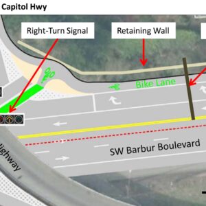
Thanks, Lisa, for the excellent reporting. Another sore spot is the dreaded “woods” section with the Vermont and Newbury bridges. Now that the SW Corridor has planned, has anyone heard if ODOT is planning to move forward with Option 3 of the Barbur Road Safety Audit that would take the right southbound lane and convert it to a R turn only lane onto Capital Hwy? It would signalize the turn, stopping car traffic when bike/ped traffic is present and add protected lanes to the bridge (currently the bike lanes completely drop out, forcing people on bikes to merge with 50mph car traffic, or ride on a 24″ wide elevated sidewalk). The proposed budget was something like $4 million, or less than 0.1% of ODOT’s budget. I’ll gladly shoot off emails to ODOT, but now seems like the time to put pressure on ODOT to make them consider meaningful changes.
Thank you, Alan, for your comments. We are planning a 2nd article which will cover the woods, the Vermont and Newbury bridges, Hamilton on into downtown. If you have other insights, please email me at the address in my byline at the bottom of the article, I’d like to get your thoughts about other spots.
This was a difficult article for me to write because there have been so many studies of the corridor over the past decade. It’s a rabbit hole, and I felt like I had to triple-check nearly every sentence. In my head, at least, the story shifted to being about how many reports had been written about Barbur! And it’s not like work hasn’t been done, it would be much easier to say “nothing’s happened in ten years” (in all caps), but that’s not true.
Regarding pressuring ODOT, it’s not clear the light rail is dead. It seems like things are in limbo, or “paused” I think TriMet said, which is why I wanted to write the story. For how much longer is paused OK?
Lisa, there’s a national consensus among transit agencies, an expectation (more like a strong desire, really) that with Biden being president and both houses controlled by the Democratic Party, that there will be an abundant flow of new federal money for transit projects, at least for the next two years.
Restripe Barbur to the Portland city limits with one lane each way, put a Rose Lane transit priority lane down the middle for the 12 and other buses. No reason not to create an urban renewal area much like Katz did for N. Interstate for funds, looking for state and federal matches while you rebuild the street for a SE Division style BRT or for LRT. Dedicate half the URA money for dense, affordable housing along the ROW.