“When completed, the new multi-use path will be a direct link between the airport terminal and the existing bicycle and path network along 82nd Avenue and through Cascade Station.”
— Mike Coleman, Port of Portland
The Portland Airport has long been one of the most bike-friendly airports in America. It already has a path on the north side of Airport Way, ample bicycle parking, and even a bicycle assembly area inside the terminal for folks who travel with their bikes. A new carfree path that’s set to break ground early next year will boost that reputation even further.
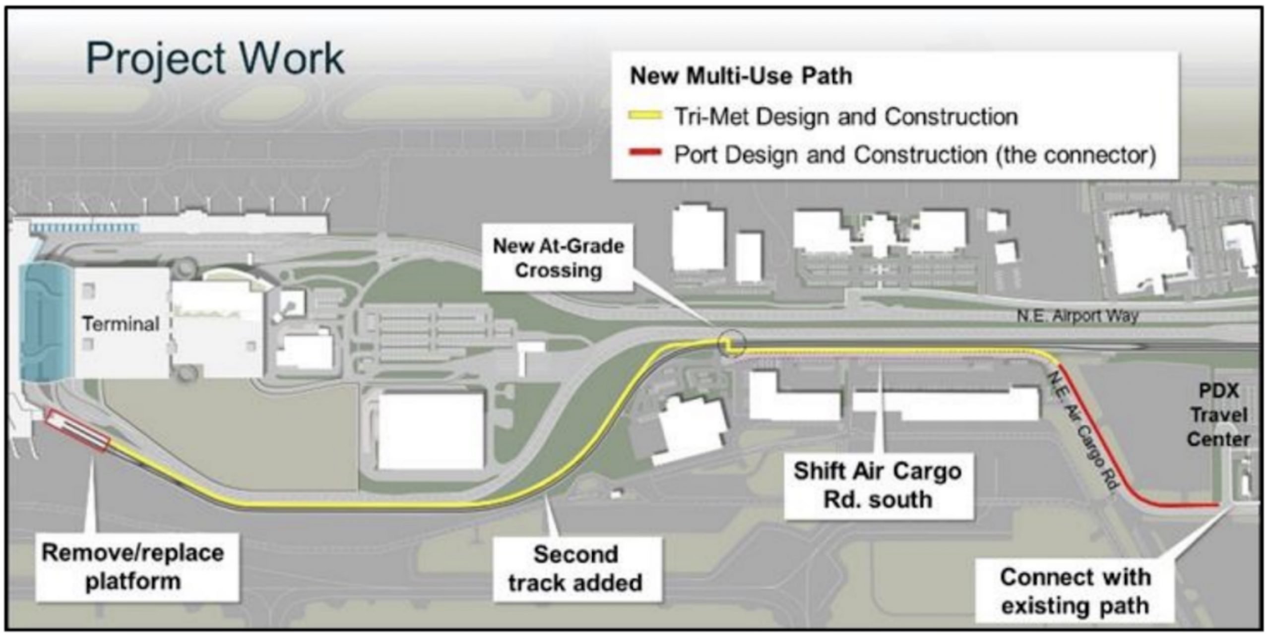
The Port of Portland tells us they plan to spend just over $6.6 million on a new multi-use path that will connect the terminal on the south side of Airport Way with an existing path (and bike lanes) on NE 82nd Avenue. The project will begin construction in January 2022 in tandem with TriMet’s Better Red project.
We first reported on this project one year ago, and now the Port has more details on what to expect. Here’s what you need to know:
TriMet will spend $215 million to add another set of MAX light rail tracks to two sections of the Red Line between Gateway Transit Center and the airport, as well as other upgrades to the line between Portland and Hillsboro. While veteran transit watcher Jim Howell says the project is a redundant waste of taxpayer money, TriMet says the new tracks and other elements of the project will reduce wait times and increase reliability across the network.
The Port has planned for a new path on the south side of Airport Way since at least 2014 when the project was identified in their Bicycle and Pedestrian Plan. When TriMet approached the Port about their plans to expand the Red Line, the two agencies entered into an intergovernmental agreement to integrate the MAX project with their multi-use path project. In addition to a new path parallel to the MAX Red Line, the Portland will seize this opportunity to extend the path another half-mile to NE Air Cargo Road and 82nd Ave.
Advertisement


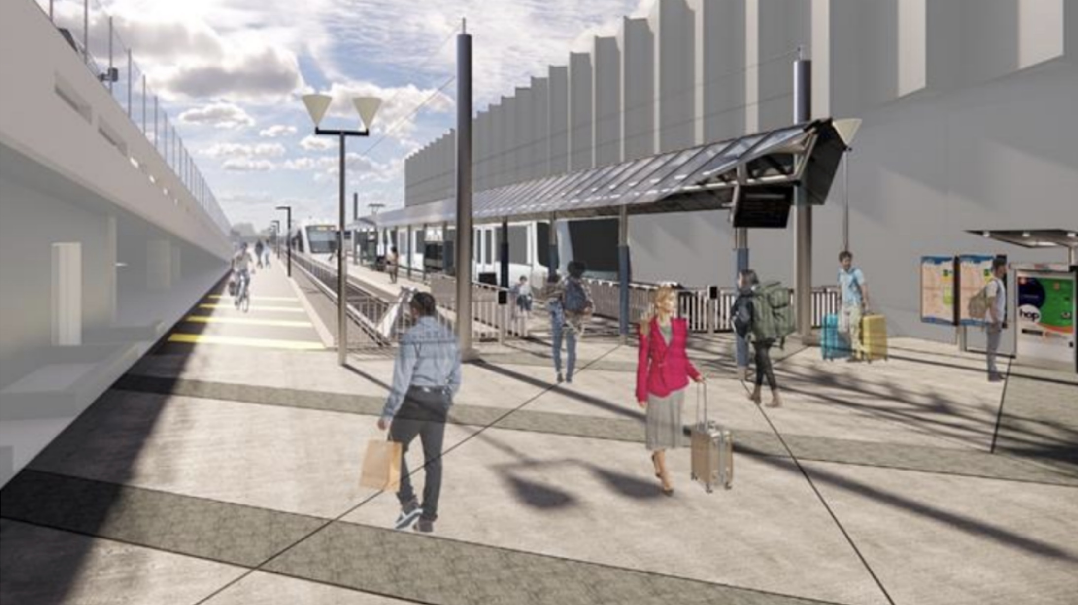
“When completed, the new multi-use path will be a direct link between the airport terminal and the existing bicycle and multi-use path network along 82nd Avenue and through Cascade Station,” shared Port of Portland Senior Planner Mike Coleman in an email to BikePortland this week. Coleman said TriMet created extra width in the design of the new MAX station at the airport terminal to fit the new path. “The integrated project approach enhances the value of the Red Line and completes a key element of the PDX Bicycle and Pedestrian Plan,” Coleman added.

Beyond the airport, this new path will tie into City of Portland projects on NE Cornfoot Road and 47th Avenue, and the new Columbia Lombard Corridor Plan. PBOT is (slowly but surely) working on a new, 12-foot path on the north side of Cornfoot between 47th and Alderwood. And they’re putting the finishing touches on a complete rebuild of 47th between NE Columbia and Cornfoot that includes grade-separated protected bike lanes. The Columbia Lombard Corridor Plan, which proposes several key projects that would vastly improve cycling to-and-from the airport, will receive its first hearing at Portland City Council today (July 21st).
Between those projects and the Port’s new path, we are getting very close to a high-quality bikeway from neighborhoods to the airport.
For Coleman, this new path and light rail upgrades represent “the continued evolution” of their vision for bike access to the terminal. The projects also come at a time when the airport is making a series of major renovations and upgrades as part of their PDX NEXT project. Those changes will include more bicycle parking near the light rail platform and terminal. Coleman says his team is also exploring a bike share system to help workers at Air Cargo Center complete the “last mile” between the MAX station and their offices.
Estimated completion of the new path is the end of 2023. Stay tuned for updates.
— Jonathan Maus: (503) 706-8804, @jonathan_maus on Twitter and jonathan@bikeportland.org
— Get our headlines delivered to your inbox.
— Support this independent community media outlet with a one-time contribution or monthly subscription.


Thanks for reading.
BikePortland has served this community with independent community journalism since 2005. We rely on subscriptions from readers like you to survive. Your financial support is vital in keeping this valuable resource alive and well.
Please subscribe today to strengthen and expand our work.
If Portland was a city of several million, those tracks would continue under the airport and under the Columbia River to Vancouver WA, similar to the Minneapolis airport and most major airports in Europe.
I find it amazing how many airports in the US ban bicycles altogether, and most of the rest make it incredibly unsafe to ride to the airport or anywhere near it.
I would love it if the NE 82nd Ave freeway portion had slightly better bike facilities on it. I always take that and then cut over to Skidmore to go further west. It is more direct and faster to get to the “good part” of the ride (neighborhood streets)
Based on the amount (lack) of traffic on that section, I wonder if it could be made 1-lane in each direction and and a really nice bike facility added
A shame there aren’t more (any) long term Park & Ride facilities in Hillsboro or Beaverton to allow for more folks to take Max to the airport.
The land is more valuable as housing. Or at least, people wouldn’t be willing to pay the amount necessary to make them viable. There are feeder buses, and there is always the option to have someone drop you off at MAX, or even Uber/Lyft to MAX. You will still save a lot of money vs. parking or Uber/Lyft all the way to the airport.
Following up on Chris’s comment, Park and Rides are a net negative for TriMet revenues and there should be no further expansion of these systems.
Yeah, but if they’re not going to expand park and ride then they need to get on it with expanding access to transit. The nearest stop to my place is 1.5miles away on a 45mph road with no sidewalk or shoulder. (40yrs ago there was a bus stop 2 blocks away) The local park & ride is so oversubscribed it’s a small miracle if you can actually get a spot.
People need to be able to access the system if we want them out of cars. Which means not expecting that they’ll walk somewhere blatantly unsafe or magically find parking where none is available.
I often use the bike path along Marine drive returning from Gresham. At first I would take the path which intersects Sandy and continue past the Prescott T.C. It has become congested with homeless camping and vehicles I opt not to use it. Instead I go down Alderwood to 92nd to Columbia to Cully or 60th. I have tried 82nd by bike and on foot. The section nearest the airport is high traffic but usable. South where it goes under Columbia is a fatal accident waiting to happen.
Obviously bike/ped infill is a good thing, but $6.6m seems like a lot for just over a mile of multi-use path, even considering the West Coast’s absurdly inflated construction costs. I’m assuming the Better Red project is paying for the pinch point near the airport on this project, so the rest of the project is just adding concrete to existing right-of-way, isn’t it? Does it really cost $100/sq ft to lay concrete in Oregon? Are there details about the project somewhere? I looked over the links in your story, maybe I missed it but I’m not seeing details of this specific path anywhere.
I can’t imagine that the cost of building that path itself is that much, but I can easily see how the path could could cost that much if they’re allocating to the path costs related to relocating Air Cargo Road, etc.
But in any case the cost of this path is a rounding error in the overall sum of money the Port is currently spending at the airport.
Maybe there’s some surface water issue that triggers storm sewer addition or modification
This is a cool project, but I’m reminded that the Port just built a ginormous new parking lot at the airport. As long as we keep making parking easy and cheap, we won’t get people out of their cars and onto Max to use the expanded track access. Induced demand is real and this project is wonderful, but feels counter intuitive to their recent parking additions.
The catchment area for air travel is more that the Portland Metro area. As the region’s population grows so does the need for more parking spaces for folks from outside Portland’s transit service, walkways, and bikeways. Convenient parking is a part of PDX’s #1 Airport Ranking. It would not be wise to risk losing that ranking because there is “inconvenient or no where” to park. Not to mention the parking revenue helps pay for many of the airports improvements/conveniences. I’m sure that revenue is in the millions of dollars. Something to consider.
I find it genuinely mystifying that this money can be allocated for bike infrastructure expansion when so many existing bike paths are rendered unusable by homeless people and their scattered “possessions?” Particularly on the airport approaches. What is to prevent these new well-meaning corridors from becoming instantly unusable to all but the bravest cyclists, once transformed into the de facto property of the homeless?
Bike paths are hard scape that is attractive for squatting, especially in an underpass, because the scattered pieces of a disconnected network are little used. Well traveled routes will be busier but scatter shot development leads to disused spaces that get repurposed.
We spent $7 million on NE 47th, with the Cornfoot gap on one end and that sketchy railroad overpass on the other. Sharrows! It’s classic stranded bike infrastructure, a separated path that just may be a little overbuilt with some vehicular mess on either side.
I’m very excited not to have to cross Airport Way to get to the airport from SE, but I’m surprised the Columbia Lombard Corridor Plan doesn’t prioritize fixing the little sliver of NE Cully between Lombard and Columbia which essentially defeats an otherwise excellent bike route to the airport from the heart of NE (and SE for that matter).
Second this. Protected lanes exist on Cully, ALderwood north of Cornfoot, and 82. A simple protected way to cross the Lombard/Killingsworth/Columbia confluence between Cully and Cornfoot would pay dividends.
Does anyone ride to the airport frequently? I’m interested in tips and tricks. I fly quite a bit, and have never noticed the bike storage or existing pasta.
I think, as far as I can tell, that the bike “storage” is simply the racks on the ground level near the MAX stops. I don’t know too much, because I’ve never done this either, but I also am intrigued about biking toPDX. I’d be more inclined if there were truly secure bike lockers that one could rent.
This might make a good topic to tackle in the forums.
I used to fly for work regularly and would bike to the airport. I’m not sure if I would do so now, given the state of the Springwater and 205 bike paths. I’ve never had a bike stolen from there, even while they were chained up for weeks at a time.
I’ve been biking to PDX for a couple of decades. The bike parking used to be in an (open) fenced in area right next to the airport police station, there was a bike parked there for at least 10 years that hadn’t been stripped. 🙂 During the renovation, they moved bike parking right up to the edge of the arrivals terminal. Wide open, but there’s so much traffic there, I felt fine leaving my bike. I have not been since the new terminal opened last july.
As for getting there, there is a well worn desire path just west of the cascade station max stop, follow it to 82nd + airport way, and you can cross airport way at the light and follow the frontage path right to the terminal. The cut-in from marine drive into the parking lot is also nice if you’re coming from north of the airport. If you haven’t ridden to the airport, I suggest doing a ride out there before flight day to familiarize yourself. There are sometimes Pedalpalooza rides that head that way.
I don’t have room for a throw-away bike in my apartment so I would never park at PDX for an extended period of time. Secure bike parking (e.g. a monitored limited-access facility) or a well-maintained biketown station would allow me to bike to PDX (which I would definitely like to do).
This path is going to set up Airport Way and 82nd Ave for more hotels and other travel-related business. There isn’t another airport in the US that has pedestrian-friendly access to hotels. I’m an airline pilot and Los Angeles is the only overnight where we can walk to the hotel. Even though LAX is a hellscape for crossing streets, walking to the hotel is such a treat. This new path at PDX will provide an even better experience because it’ll have fewer street crossings. A pedestrian-friendly Airport Way could potentially transform PDX and the surrounding area into a unique travel facility. We already have one of the few airports with direct train access, this path is another huge win.