(Photo: Jonathan Maus/BikePortland)
This is the second part of a two-part article on Southwest Barbur Boulevard’s infrastructure needs by our SW Correspondent Lisa Caballero. Read part one here.
For years, much-needed changes to Barbur Blvd have been linked to building the SW Corridor light rail project, which would run along Barbur Blvd through its SW Portland segment. When voters rejected the Metro transportation funding measure in November, the light rail was left without a funding mechanism and safety improvements to Barbur have been in limbo.
Without support from the funding measure, TriMet has paused the light rail project and is completing its final Environmental Impact Statement to ensure it is, “eligible for future federal funding if the region identifies resources to restart the project.”
The need for safety improvements to Barbur, unfortunately, can’t be paused. With the SW corridor project stalled and its future uncertain, now seems like a good time to revisit ideas that were being discussed before the corridor’s future became bundled with the train.
Advertisement
This two-part series reviews a decade of advocacy, government studies and road improvements. Our first article examined the “diagonal” running from the Burlingame neighborhood south to the “Crossings” intersection with Capitol Highway. This article focuses on the northern section of Barbur, from “The Woods” into downtown.
The Woods and Bridges
(Photo: Jonathan Maus/BikePortland)
A decade ago, almost to the week, veteran southeast Portland bicycling advocate Keith Liden sent an email to the Oregon Department of Transportation. He had ideas about how to make the northern segment of Barbur Boulevard safer for people walking and riding bicycles.
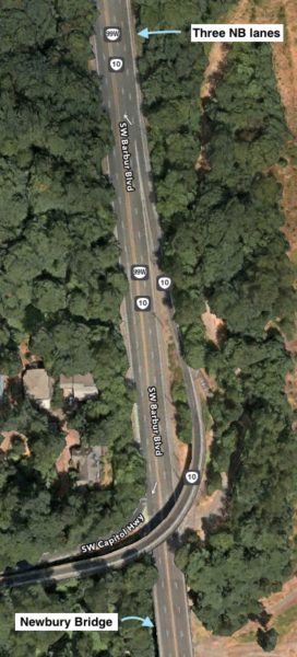
With three northbound travel lanes into downtown, Barbur was oversized, he argued. The completion of I-5 nearly a half-century earlier meant the road no longer had to accommodate the regional and interstate traffic it once did. Barbur needed a road diet, starting with the Newbury bridge.
The Newbury and the Vermont bridges are in “the woods” segment of Barbur, and span deep ravines in the George Hines Park, to the west. Both Barbur Blvd and the bridges were completed in 1934 and were built on the recently deeded right-of-way of the Red Electric Train. At that time, Barbur ran from downtown Portland to the then western edge of the city, near SW Bertha Boulevard and the Burlingame Fred Meyer. A year later, the state completed Barbur’s southern extension along “the diagonal” to the Multnomah County boundary with Tigard. This county/city history explains the difference in character between the northern and southern segments that we still see today. The county section was built as a car-oriented business district, with motels, filling stations and restaurants. The northern “wooded” segment runs parallel to Terwilliger Blvd where city zoning prohibited commercial buildings and billboards.
Because of the steep topography and early zoning decisions, Barbur along “the woods” lacks cross streets, signals or businesses to create friction for the through traffic. This limited access results in the highest recorded speeds on the corridor.
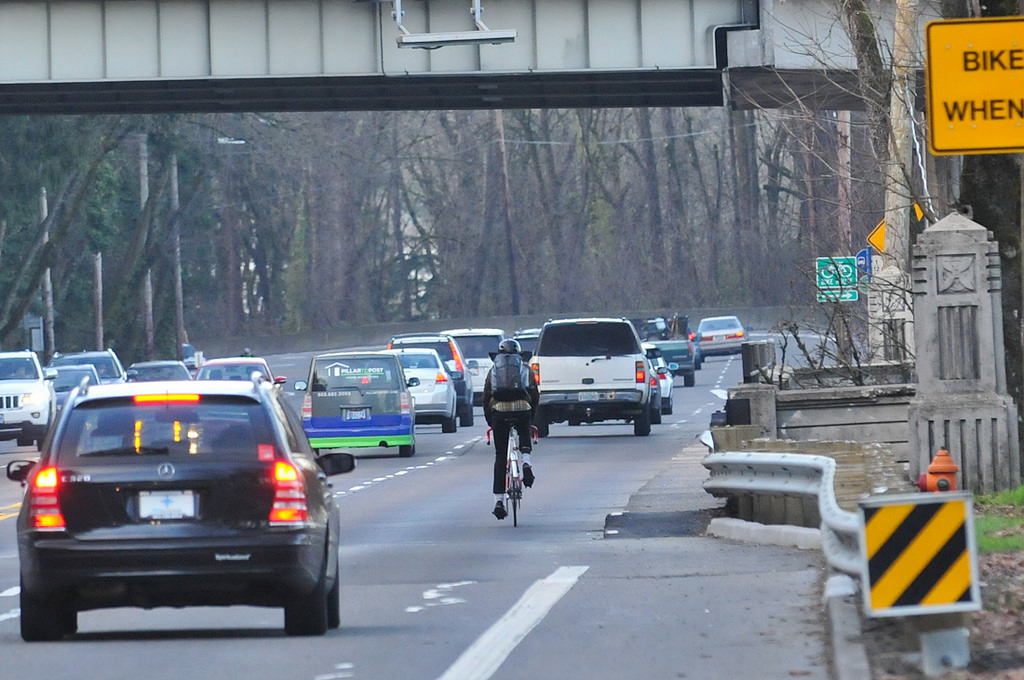
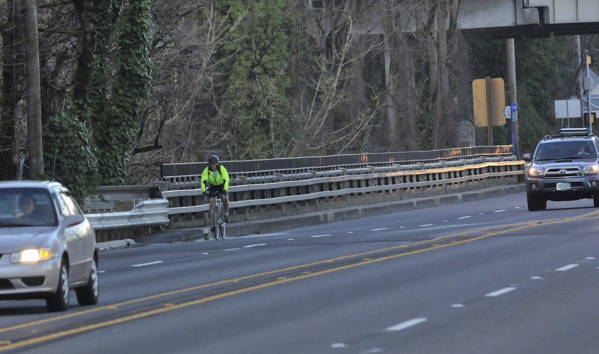
The two bridges are the most perilous section of “the woods.” Each has four travel lanes, but lacks bike lanes or a safe pedestrian sidewalk. To use the bridges, cyclists must merge from an abruptly ending bike lane to take the right lane from cars which are speeding along between 45 and 55 mph (see top photo). This is extremely dangerous, and it prevents all but the most experienced cyclists from using Barbur.
Liden proposed merging northbound traffic from two lanes to one, just south of the Newbury Bridge, and re-establishing two travel lanes with the on-ramp of the Capitol Highway flyover. This reduced, three-lane cross-section over the bridge would make room for bike lanes in both directions. He added that this northbound lane reconfiguration should continue between Capitol Highway and Naito Pkwy, and that the off-ramp from northbound Barbur to Naito should be only one lane.
Advertisement
Liden wasn’t just any concerned activist, he had been on the advisory committee for the 1996 Portland Bicycle Master Plan, was a member of the Portland Bureau of Transportation Bicycle Advisory Committee from 1993 to 2019, and is a former member of the Metro Transportation Policy Alternatives Committee (TPAC).
ODOT responded to Liden several months later. In a detailed response, they explained why his suggestions were not feasible.
Although they acknowledged that “accommodation of bicycles on state highways is essential to multi-modal” and that “this highway is a vital connection point between north-south routes … many structures existing today were not constructed with the intentions of providing a 6-foot bike lane in either direction of travel.” ODOT’s litany of excuses included: Removing a lane would cause congestion for car users during peak traffic hours and could cause an increased number of crashes; Barbur capacity cannot be reduced as it is an alternate route to I-5 and a possible emergency evacuation route; and extra capacity was needed to accommodate future driving traffic demand.
Liden felt that ODOT wasn’t looking for solutions to the safety problems with an open mind. Exasperated, he stopped pursuing the idea.
The Battle is Engaged
Two years later, at the end of 2012, activists saw an opportunity to renew their calls for a road diet. ODOT was planning the Vermont/Newbury Bridge Preservation Project for retrofitting to prevent the bridges from becoming weight-restricted to trucks and TriMet buses (the project ended up also including safety elements such as a higher pedestrian safety railing, water drainage, and the installation of an automatically triggered “Bikes on Bridge” flashing beacon).
This led to an all-hands-on-deck advocacy push to include bike lanes with the project. Advocates included the Bicycle Transportation Alliance (now Street Trust), Oregon Walks, the City Club, neighborhood activists, PBOT’s Bicycle Advisory Committee, PBOT’s Bike Coordinator Roger Geller, the Lewis & Clark College Sustainability Council, and a new group named Friends of Barbur Blvd that emerged specifically to push this issue.
Advertisement
The lobbying effort was successful in that it prompted a direct response from ODOT to specific issues and forced the agency to collect additional traffic flow data during the four-month construction-required lane closures. That was a big win. Fast-forward a couple of years, ODOT completed the bridge repairs in the summer of 2014. It used the opportunity to conduct a traffic flow study during the naturally arising experiment of actual lane closures, and it released a traffic report in December 2014 which noted a 68% reduction in excessive speeding, no traffic diversion into neighboring streets and a more-than-predicted traffic delay.
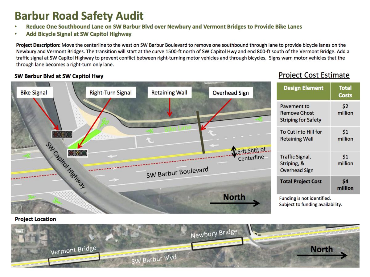
One of the most interesting observations gleaned from the study is that about 40% of southbound Barbur traffic turns west onto Capitol Hwy. In other words, southbound Barbur traffic between Capitol Hwy and SW Miles is only 60% the volume of southbound traffic north of Capitol Hwy. This observation made a strong case that a southbound lane could be removed on the bridges without causing prohibitive congestion.
The demand for change continued to gain momentum when State Representative Ann Lininger pushed for the 2015 Barbur Road Safety Audit (which included designs for seven different bridge scenarios, four of which involved lane diets) and even Portland Transportation Commissioner Steve Novick and U.S. Congressman Earl Blumenauer called for action from ODOT. Finally, in 2016, ODOT acknowledged the need for a road diet, and offered a plan to remove one southbound lane from Barbur to allow for bike lanes over the bridges.
Advertisement
By 2017, the agency had produced a “Fact Sheet” which explained that ODOT had spent $8 million in the previous four years for Barbur safety improvements in Washington County and Portland, and it outlined upcoming work, including more detection loops at the Newbury and Vermont Bridges, bike lane restriping, and green bike boxes and signalling at Terwilliger — but there was no mention of a road diet.
The story doesn’t end there. Throughout this multi-year advocacy effort, ODOT’s responses often deferred to the developing Southwest Corridor Plan. Ultimately, in 2018, ODOT announced that they were intending to transfer jurisdiction of the bridges and Barbur Blvd to the City of Portland, and would contribute to rebuilding the bridges to accommodate the light rail.
Next Steps
The other thing that happened in 2018 is that a chunk of concrete fell off the Capitol Hwy fly-over, which required that Barbur lanes be reduced to one in each direction for repairs.
(Photo: Jonathan Maus/BikePortland)
Bike Activist Eric Wilhelm said that closure proved a point. “All they need is the willingness to implement a tactical road diet, like they did in July 2018 when absolutely no sky fell — except the bit of concrete which fell out of the BH/Capitol Hwy ramp).”
And Keith Liden hasn’t given up either. He recently emailed me to say, “Now that Southwest Corridor is stalled for at least a few years, it would appear to be a good time to revisit this, along with the Barbur/Naito intersection and downtown entry of Barbur onto SW Fourth Avenue.” He pointed out that making Barbur a great bike route between downtown and Burlingame doesn’t have to be expensive, it can involve paint and maybe some delineator wands and curbs.
If we can muster $9.5 million for the Flanders Crossing bridge over I-405, finding a fix to get bicycle riders through the “woods” without any scary surprises should be an easy lift.
— Lisa Caballero, lisacaballero853@gmail.com
— Get our headlines delivered to your inbox.
— Support this independent community media outlet with a one-time contribution or monthly subscription.



Thanks for reading.
BikePortland has served this community with independent community journalism since 2005. We rely on subscriptions from readers like you to survive. Your financial support is vital in keeping this valuable resource alive and well.
Please subscribe today to strengthen and expand our work.
Thanks again, Lisa, for the in-depth coverage of Barbur. The “woods” section is part of my daily commute so safety improvements are near and dear to me and many others. To your knowledge, has ODOT signaled any intent to move forward with the Barbur Road Safety Audit? I emailed them a few weeks ago with no reply. I’ve also made a habit of emailing some of the Region 1 ODOT managers every time a vulnerable road user dies on SW Barbur to remind them that their indecisiveness on safety improvements has direct consequences. Prioritizing driver/freight convenience over human life really shows what ODOT stands for.
Hello Alan, thank you for the comment. I haven’t heard anything about further ODOT work on Barbur. My guess is that the “no” vote on the Metro transportation measure has thrown a lot into the air, so I’m not expecting much from TriMet, Metro, or ODOT on the SW Corridor/Barbur until TriMet gets a new general manager.
But I agree with Keith Liden, and Kiel below, it’s sobering that with all the pressure from savvy activists and politicians, that we still don’t have relatively inexpensive road diet fixes that would calm speeding drivers and give more room to people on bikes. It should be done now, even if it’s only to tide things over for five years before a light rail goes in (IF a light rail goes in).
ODOT is pretty good about publishing upcoming road projects, and they have useful filters. Barbur is 99W: https://www.oregon.gov/odot/Projects/Pages/default.aspx?wp701=so:%5B%5B81785,1%5D%5D,f:{o:0,a:{c:81785,o:{t:2,o:[%22Portland%22]}},b:{c:18077,o:{t:2,o:[%22OR+99W%22]}}}
Alan, I’m going to take a 2nd shot at responding, a little more precisely this time. David Hampsten is correct, ODOT does a good job of publishing upcoming work. One big project that is coming up I wrote about in Part1-the controversial “jughandle” redesign at where Capitol Highway crosses Barbur.
And then, regarding the Safety Road Audit, that’s a wonderful report which runs to about 100 pages. The group which produced it was made up of traffic engineers from PBOT, ODOT, the feds, private consultant companies, the county, and they road bikes along Barbur. ODOT has already done many things the RSA recommended.
But I’m not aware of any movement on road diets, and importantly, RSA didn’t recommend a road diet. There was no consensus opinion, and they didn’t think it was their mandate to recommend operational changes. They instead offered seven cross sections designs, starting on page 83. Four of them take away lanes to put in bike lanes.
Such a frustrating section. If Portland can’t figure out a way after all this time and all this effort and political support to improve Barbur what chance do other places have? ODOT is a broken institution, if they want to show a commitment to other modes besides cars a road diet here is a good and easy place to start.
Oregon in general is a pretty broke state. Very pretty.
This stretch of Barbur used to be on my daily evening commute. Just incredible how many years we are having to wait for this.
I remember in 2012-2014 ODOT making the excuse that Barbur would be redesigned anyway for SW LRT, so we should wait. Well, here it is, 2021, and that project is on hold.
We also had the excuse that removing a travel lane would lead to congestion, a claim that doesn’t even pass the most cursory analysis. There are no intersections through this section, a remarkable situation in a city. Roadways without intersections function essentially like bridges, and even a first year traffic engineering student will tell you the normal working assumption that bridges have twice the traffic capacity per lane as ordinary roadways.
Furthermore, even if a merge from two lanes to one (in the northbound direction) in advance of the bridges occasionally caused a backup, the chance of it backing up half a mile to the first intersection back there is pretty much zero.
I can’t even dignify the other excuses ODOT has made about service level, being an emergency route in case something catastrophic happens to I-5, etc. Obstruction-R-Us.
I also remember the 2014 project where they “fixed” the bridges, put in the flashing yellow lights, and the not-quite-an-alternative of riding the bridge sidewalks became oh-so-slightly less dicey. At the time it seemed that you had to be on the shoulder FAR too long in order to trigger those signals: most cyclists know better than to move into the car lane that late, and risk “startling” motorists that are bearing down at 50mph. A shame that in 6+ years this has never been adjusted.
All in all, just terribly disappointing that really NOTHING has happened in so many years.
I do think that ODOT in general gets too much hate on this blog, but I’m in agreement with everything written here. This is a dangerous situation with such an easy, intuitive fix, and ODOT really needs to step up their game on this one.
The line that having two lanes is necessary for an alternative to I-5 in case of issues there doesn’t resonate with me. If a bike route is closed then neither PBOT nor ODOT care enough to provide safe alternatives to cyclists, but they do care enough to provide an alternative for cars apparently. For a nearby example, the time that Terwilliger was closed, certainly nobody cared enough to provide a safe alternate route for bikes at all.
What’s wrong with one lane? Well, one person driving at the speed limit minus one would screw it up for everybody else!
Right. Let’s not have anyone follow the speed limit, that’s anti-American.
Oh would it, now?
Road diets in Portland are typically about reducing the number of lanes, from 4 to 3 for example. But out here in NC, along with some 3-lane diets, we often see road diets of reducing lane widths from 12 or 13 feet down to 10 feet (in rare cases down to 9 feet), with a concurrent reduction in posted speed limits and changes to signal timing. The narrowed lanes often allow for adding or expanding bike lanes or buffered bike lanes. Have any of the Barbur proposals included narrowed car traffic lanes?
This could help along much of the route, but the bridges needed way more room than reducing each lane by a foot or so.
There’s unfortunately a new situation in “the woods” on Barbur: cars parked in the bike lane, apparently so they can re-supply camps on either side.
I rode Barbur in both directions yesterday and TWICE had to move out of the bike lane to avoid cars parked in the bike lane. So the unregulated camping is having an impact on safety on Barbur.
Also the bike-activated flashing beacon on one of the bridges (Newberry, I think) isn’t working, which seems to happen every winter.
As for the road diet, it’s a no-brainer. I can say for a fact that cyclists in my own household will NOT ride Barbur b/c they don’t feel safe merging into traffic on the two bridges. So until those bottlenecks are fixed, don’t expect most people in SW to get on their bikes and fight the looming climate catastrophe.
This is also a huge problem on Marine Drive and NE 33rd. The bike lane on 33rd is completely unusable for about a mile. So dangerous.
Yes Fred, I’ve seen it too. Last week, I was out under the Capitol Highway flyover with Don Baack for an article on the Red Electric. As we walked down the remnants of Slavin Rd, we saw a fair amount of camping. And one woman had a van parked parked at the mouth, but she was careful not to have it in the bike lane.
Regarding you last sentence. I’m waiting for the story line to eventually develop that folks in the SW are just car drivers and won’t do their share to stop climate change. The truth is we have sparse bus service, the smallest percentage (by far) of sidewalks on arterials/collectors of any area in Portland, and a very incomplete bike network.
Barbur is a really important road to make safe for people on bikes as it is the easiest grade through the SW.
I wonder who owns the land and why they are allowing people to camp on it. If the land is publicly owned and managed (perhaps by ODOT?), they should be doing more to keep people from camping there. I can only imagine what the human-waste problem is like.