Yesterday the Oregon Department of Transportation did something unprecedented: they officially proposed re-allocating lane space on on Southwest Barbur Boulevard to make less room for driving and more room for cycling. Here are their exact words: “Reduce one southbound lane on SW Barbur Blvd over Newbury and Vermont Bridges to provide bike lanes.”
This great news came in an announcement yesterday that came with the release of new documents published by ODOT in response to the Barbur Road Safety Audit that came out back in October. The audit was performed by a private consultant and it included some significant findings on how to improve cycling access on this major arterial street that’s the most direct connection from southwest Portland into downtown. One of its ideas, which we highlighted in detail a few days after the audit was released, has now been embraced by ODOT and is part of an official package of proposed improvements they’d like to move forward on.
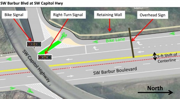
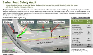
There’s a lot to digest in ODOT’s response to the audit; but the big one has to do with the southbound section near SW Capitol Highway, just north of the Newbury Bridge. As we reported last fall, traffic data shows that 40 to 50 percent of southbound Barbur auto traffic exits at Capitol. This fact makes it reasonable to re-stripe the roadway space from the existing two standard lanes (that force bicycle riders to merge with auto users) into one standard lane and one bike-only lane. In addition to the lane re-striping, ODOT would add a bicycle-only signal at Capitol Highway to improve safety at this high-risk and high-speed intersection. Here’s the full project description followed by a screenshot of the document:
Move the centerline to the west on SW Barbur Boulevard to remove one southbound through lane to provide bicycle lanes on the Newbury and Vermont Bridges. The transition will start at the curve 1500-ft north of SW Capitol Hwy and end 800-ft south of the Vermont Bridge. Add a traffic signal at SW Capitol Highway to prevent conflict between right-turning motor vehicles and through bicycles. Signs warn motor vehicles that the through lane becomes a right-turn only lane.
Advertisement
At this point, ODOT isn’t breaking ground or anything. And they haven’t allocated the $4 million it’ll take to do this work. But the fact that ODOT has now officially acknowledged the need for a road diet on Barbur is a very big deal. It’s a victory for all the advocates and electeds who have pushed for changes on Barbur over the years.
Speaking of which, we first shared a grassroots effort to make Barbur better for cycling in 2010 when a pair of Portland State University students started a Friends of Barbur group. The three years later the idea came roaring back into the news when ODOT released plans to rehabilitate the Vermont and Newbury bridges. Advocates — including the Bicycle Transportation Alliance who made this one of their top priorities — seized on that project as a perfect opportunity to re-stripe the road and put a separated bikeway over the bridges. As crashes and tragedies continued to happen, pressure mounted on ODOT to put the road on a diet but they resisted at every turn.
The road safety audit conducted last summer was the big breakthrough (and it helped that it was pushed for by State Representative Ann Lininger). This past November the pressure reached a breaking point when Portland Transportation Commissioner Steve Novick and U.S. Congressman Earl Blumenauer both urged ODOT to act.
This project is far from a done deal, but this breakthrough is worth celebrating. And it took endless pressure from many corners — from grassroots activists to the Bicycle Transportation Alliance and even the city’s own Bicycle Advisory Committee.
Stay tuned for more on this story. For now, peruse ODOT’s full response and list of projects they want to implement on Barbur in the coming years at Oregon.gov.
— Jonathan Maus, (503) 706-8804 – jonathan@bikeportland.org
BikePortland can’t survive without subscribers. It’s just $10 per month and you can sign up in a few minutes.



Thanks for reading.
BikePortland has served this community with independent community journalism since 2005. We rely on subscriptions from readers like you to survive. Your financial support is vital in keeping this valuable resource alive and well.
Please subscribe today to strengthen and expand our work.
FINALLY!!! I was beginning to get itchy regarding ODOT’s analysis of the RSA. There will certainly be some quibbles from some of us regarding the intended design, but from the graphic above, this is a huge step in the right direction. I bike this every day, and refuse to wait 20 years for the SW Corridor plan to come to fruition. This could happen very soon if we had the political will.
Now to wait for the excuses on why it can’t be done…
Whoops, just realized I stole your headline, Jonathan. But it needed more exclamation marks.
This would be a game changer for SW Portland. Completing this project would allow many more people in SW who are fearful of riding a bike have safe access to connect to the rest of the city. Let’s make it happen!
YES and lower speed limits!
Let’s make it happen sooner rather than 3 years and $4M later. Striping and signage changes would be safer than what we have now.
Yes! And when is Portland going to finally do that Capitol Highway bike lane project?!?!
This is a great start. As a next step, it would also be great to get better facilities going north, but south is easily more dangerous and frightening. Obviously barriers or some other physical protection would be ideal, but I’m not holding my breath.
I’m very glad this would explicitly handle the turn to Hillsdale as well; cars love to race to turn there before you ride through so they don’t have to yield. Hope they allocate the money and we get a solution soon …
Looks like the project is to put bike lanes both ways. The center line moves 5 feet to the west: which means the existing 10 foot lane is being allocated to 5 foot lanes in both directions.
*Edit: proposal, not project. Getting ahead of myself!
Aha! I follow now, thanks for pointing that out.
This would be nice, but the ramp from Barbur to Naitto is the worst part for cyclists and that would be a city decision I think for that fix.
That stretch is far more dangerous than the bridges.
Fortunately this is a downhill stretch with a run in to it. Merely follow the corner to the right and merge to the left lane like the “Oregon Driver’s Manual” suggests for cyclists on a one way street. about half or better of the motorists are trying to get into the right lane to take the exit to the Ross Island bridge. Never had a problem here in at least 4 decades of riding this stretch.
It is the 2nd merge with the Ross island traffic and the crappy pavement that almost gets one killed…..I too, ride it every day and have for 10 years.
Kudos to SW PDX activists and the BTA who pushed hard for many years on Barbur! We need to keep pressuring ODOT so that this and other improvements (e.g. a buffer) actually happen.
Do not remove vegetation unless it is dead or a weed.
Is that a protected intersection I see? 😀
A consistent 35 mph speed limit is needed from on this state highway from the bridge over the Tualatin River until the SW Hamilton Street intersection.
Wowx2…it sounds good…will need to dig into this report deeper before I let my emotions get ahead of the data.
[It just shows what can potentially happen when engineers update their data and approach design from a fresh perspective.]
It seems like it will be important how the road is re-striped in the areas that are not on one of the two bridges. If they make the existing car lanes wider and leave the bike lanes the same width, cars will encouraged to travel at even faster speeds than they do currently.
I hope that the bike lanes neck (from comfortable to acceptable) and not the car travel lanes.
Yet another bike lane to the right of a right-turn-only lane???? Another crap design from ODOT. No thanks!
What should be done?
RIGHT
TURN
ONLY
(EXCEPT
BIKES)
Some sort of merge/mix lane to get into a bike lane between the Right and Straight travel lanes is NOT appropriate through here. It’s a slight uphill, so bike traffic is moving anywhere from 8 to 18 mph, whilst auto traffic is going 45ish. I would much prefer the above concept to a mixing lane. And the reality is that there just isn’t enough political capital/pressure and funding on the line to build anything more significant than this proposal. Remember the old aphorism about good vs. perfect.
Agreed, a mixing zone would be an absolute disaster here, with cars going 35-45mph or more and bikes typically going 8-10 up the hill.
Nobody would have to merge into a 45-mph through lane. The turn-only lane, with the reduction in turn radius onto Capitol Hwy., would likely contain auto traffic going 15 to 20 in preparation for the turn. With the turning radius change forcing a slower turn, one of two conditions is likely to be present here: either faster traffic that is very sparse, affording opportunities to merge with plenty of big gaps, or heavy traffic that is very slow due to queuing up for the turn, affording an easy merge with same-speed traffic.
This is international best-practice. The bike lane should always be along the curb. If there is sufficient signaling and sight lines (created by moving the stop bar for bikes further forward) then right-hook risks are greatly reduced. Sandwiching the bike lane in-between the travel lane and right turn lane creates conflicts and only moves the right-hook further back.
It’s not a design. There’s a long way to go, let’s not crucify them yet.
it appears to be time-separated – i.e., separate signal phases for through bikes and right-turning motor vehicles.
Hard to tell exactly where they’ll be, from the little diagram:
http://bikeportland.org/wp-content/uploads/2016/03/barbur-caphwyplan.jpg
…but it appears that both the southbound bike lane and main lane of travel will have red-yellow-green signals at the Capitol Hwy turnoff. Questioning, as B. Carfree has done:
http://bikeportland.org/2016/03/16/finally-odot-acknowledges-need-for-a-road-diet-on-sw-barbur-blvd-177892#comment-6640278
…how the signals will be set to handle traffic, is important. Would people riding the bike lane, control main lane traffic, obliging it to come to a stop, by the use of a button provided on a pole? Or would it be done with a sensor or some sort? Also, how long after someone using the bike lane, activates the signal, would main lane traffic be brought to a stop so that the way would be clear for bike traffic to proceed across the turnoff?
Doesn’t that sketch depict a signal of some sort?
Would be great to see Barbur taken down to one lane in each direction for the (hopefully) Light Rail project projected to go down Barbur.
I got chills down my spine when I started reading this.
So where do we direct our voices to get this funded?
http://www.odotr1stip.org/explore-by-program/enhance/
And sadly, the newly announced 2018 STIP has insufficient funding for Barbur and a decrease in safety/ped/bike funding from the previous STIP.
ODOT knows.
Hi Folks,
I’m worried this news may not be at all what it appears. In the summary of ODOT’s response to the safety audit, they list the lane reduction diagrammed here as but one of three intermediate-term (3-5 years) options. The other two are to do nothing, or provide only a southbound bike lane.
Furthermore, in Rian Windsheimer’s letter to the Barbur Blvd. stakeholders, he grouses about making any improvement, since it would be removed when SW Corridor comes through in a decade or two.
So I’m worried that what we have here is a beautiful rendition of what ODOT *would* do, should they so deign to provide safe bike access sometime in the next few decades.
Also, there is no info here about whether the proposed lane reduction woudl include ADA sidewalks. This was a major issue in the community response to the Audit, and it has not been addressed at all.
As much as I’d like to celebrate, I don’t think we’re there yet.
Sigh.
Both bridges need ADA ramps. How about cheap rubber ADA ramps?
As for money, ODOT could cancel any one of a number of road widening projects they have in the works all over the state. There’d be no downside to this because road widening does nothing good for anybody, least of all car traffic.
Looks like ODOT just found $196,000,000.
I can see this being built. I can also see the signal cycles set so that cyclists get a full 70 second wait while motorists get greens almost all the time. Being third-class citizens means that we get excited when we’re given second-class treatment.
I’m pretty sure you’re allowed to make a right-on-red against a red arrow unless specific signage prohibits it. But you’re not allowed to go through the red bike signal even if it’s clear. Considering how most drivers roll right-on-reds, that looks like an ALWAYS GO TIME FOR CARS design.
The solution is pop up spikes.
Bollards are the gold standard for protecting against motor vehicle intrusion. http://bollardsolutions.com/automatic-retractable-bollards/
I’m all for this project but what happens when LRT is built on Barbur? Hopefully the two projects are coordinated so we’re not ripping stuff out a few years later. It’s not too much to ask local governments work together, is it?
New bridges on Barbur will likely be built there and over SW Multnomah Blvd and elsewhere.
That is less of a concern with LRT, as a tunnel under OHSU would make more sense if you are running LRT with 100% dedicated ROW.
BRT is much more likely for the Southwest Corridor. I believe this section will likely be a shared space (no dedicated transit lanes). BRT on Barbur will only need dedicated space in the congested areas of the corridor.
BRT for the SW corridor is a terrible idea. Just look at the clusterfsck going on currently with the Powell-Division project. TriMet and Metro can’t even meet the federal requirements for BRT capacity because all parties are unwilling to come to a solution that involves reducing auto capacity.
BRT works well when done right, but BRT as it is implemented in the US is toxic to public transport systems because we still put car travel ahead of the bus. With light rail, it at least forces you into dedicated lanes.
Well, we all know how tRI met does with bike and pedestrian design. Hey trimet, wouldn’t it have been awesome if you placed a mup along the length of the system? Imagine…a real people highway.
This is fantastic, and exactly what we’ve been demanding for several years. I’m glad ODOT’s engineers have finally recognized what the rest of us already knew: traffic volumes aren’t high enough to require 4 general lanes on such a long stretch without intersections.
As for LRT (or whatever goes in for SW Corridor), let’s get this done now. SW Corridor is at least a decade away; we can fight for the right bike-friendly design on Barbur when the time comes.
And with this already in place it will be easier to do so, because we will demand that ODOT not reduce the bike LOS through here.
Yeah, I’d hesitate to speculate where we’ll be w/r/t transportation priorities a decade hence. A lot can and will have changed in the next ten years. Heck, by then we may not need any lanes for cars….
It won’t happen.
1. All present capacity on Barbur will be needed, especially when the current new crop of hipster-renters decide to buy homes and the only ones they will be able to afford will be far out from the city center.
2. Long distance bicycle commuting along the Barbur Corridor won’t happen. Sure, your Hawthorne and Broadway Bridge bikies only go a few miles. But very few folks will go more than five. Especially in the drippy winter months. And then uphill to boot. Ugh.
3. Too many stretches of the Barbur Corridor are unsuited for high density development. You might get some infill closer in, but beyond that you’ve got long stretches of mostly steep hills and trees. Therefore, the distance from where foreseeable housing development would take place to where the business districts is, is too great for regular bike commuting. The McLoughlin Corridor has a similar problem, with long stretches that will never get infilled. Except the Barbur Corridor is 3 times worse.
Yup, the summer soldiers will be gone come next winter. And all this plotting and planning about how you are going to change things will just be more gibberish.
I ride Barbur every day to Tigard, what exactly are you talking about?
Speaking confidently doesn’t make your ridiculous statements less wrong.
“And then uphill to boot.”
Uh, my Barbur commute was downhill, not uphill. You do realize hills can be ridden both directions?
How many dead and/or seriously injured cyclists did it take to get this far?
The same goes for every road. The silent war is the one that rages around us with the bodies of children and adults piling like cord wood.
There’ve not been collisions on Barbur Blvd that caused people that were biking to be dead or injured. No reported collisions involving people biking at or on the Newbury and Vermont Bridges. I should say…there may have been some such collisions, but probably not in the last ten years or so.
Some four or five years ago, there was a collision involving a motor vehicle and a young woman walking, but that was further north of the bridges. There have been a few single vehicle motor vehicle collisions, reported within the same period of time, though they were much farther south, past the Capitol Hwy turnoff.
The big deal with Barbur Blvd, isn’t collisions that have happened, but that some people are of a mind that this is a road that they think would be great for biking, except that it lacks continuous bike lanes at the two points across the Newbury and Vermont Bridges…fancy names for nondescript little concrete bridges used to cross over a couple ravines…if you visually take the terrain in while crossing them, you can get a sense of the ravines you’re crossing.
For people that believe they just have to use Barbur for their daily commute, I suppose better functionality of this road for biking, is important. Generally though, aside from a few fleeting viewpoints across the river to the east and to Mt Hood, it seems to me that the fast, noisy, dirty, heavy use of this road with motor vehicles, makes the road a lousy one for riding, continuous bike lanes or not.
One too many?
I ride my motorcycle on Barbur everyday. I ride the speed limit, and I am passed like I am not moving, even by Trimet. There is zero enforcement of the speed limit on this and just about every other road in this town; Barbur is just special because of its geographic importance. I’d like to see Barbur modified too, but I’d like to see every road modified.
Yesterday I had an exam at the VA in Hillsboro, so I rode 26. I was barely past the tunnel, going the speed limit, and a huge swarm of cars just kept zooming past me like it was Nascar. There was absolutely no respect or even acknowledgement that there even was a speed limit.
My point is that speed cameras are the real answer. Plus they pay for themselves 😉
In Oregon, 20-30% above the ‘speed limit’ is the generally accepted speed by the public and law enforcement alike. It has been like this for the forty years that I have been here, and will never change. Get used to it. If you are riding/driving the ‘speed limit’, you are impeding traffic. I’m not saying it is ‘right’, but it is the reality.
I agree. First things first, where are the speed cameras?
Lars Larson loses his mind.
Too late.
Making an assumption there about a mind to lose.
Still absolutely NOT 8-80 infrastructure, but it does need to be done. We need some real cycle-track/bike highway type infrastructure running as primary cycling arterials into the SQ, SE, NE, etc. It’s nice ODOT ponied up, and glad they’ve finally got their mess together enough to finally admit this, but it’s still going to be dangerously unsafe considering motorists’ behavior on that road!
Be safe out there everybody! Cheers…
…and I’m looking forward to seeing this get done, I MIGHT actually take that route sometime with said changes.
What would you like along Barbur by SW 19th?