
Over a decade after it was listed as a “recommended project” in the Portland Bicycle Plan for 2030, the 4M Neighborhood Greenway is finally moving forward.
At their meeting Wednesday morning, city council will authorize the Portland Bureau of Transportation to put the eastern portion of the project out for a construction bid. The $2.2 million project (funded via $550,000 from 2016 “Fixing Our Streets” gas tax increase and $1.6 million in Transportation System Development Charges) is expected to be built in the 2021/2022 fiscal year.
Advertisement


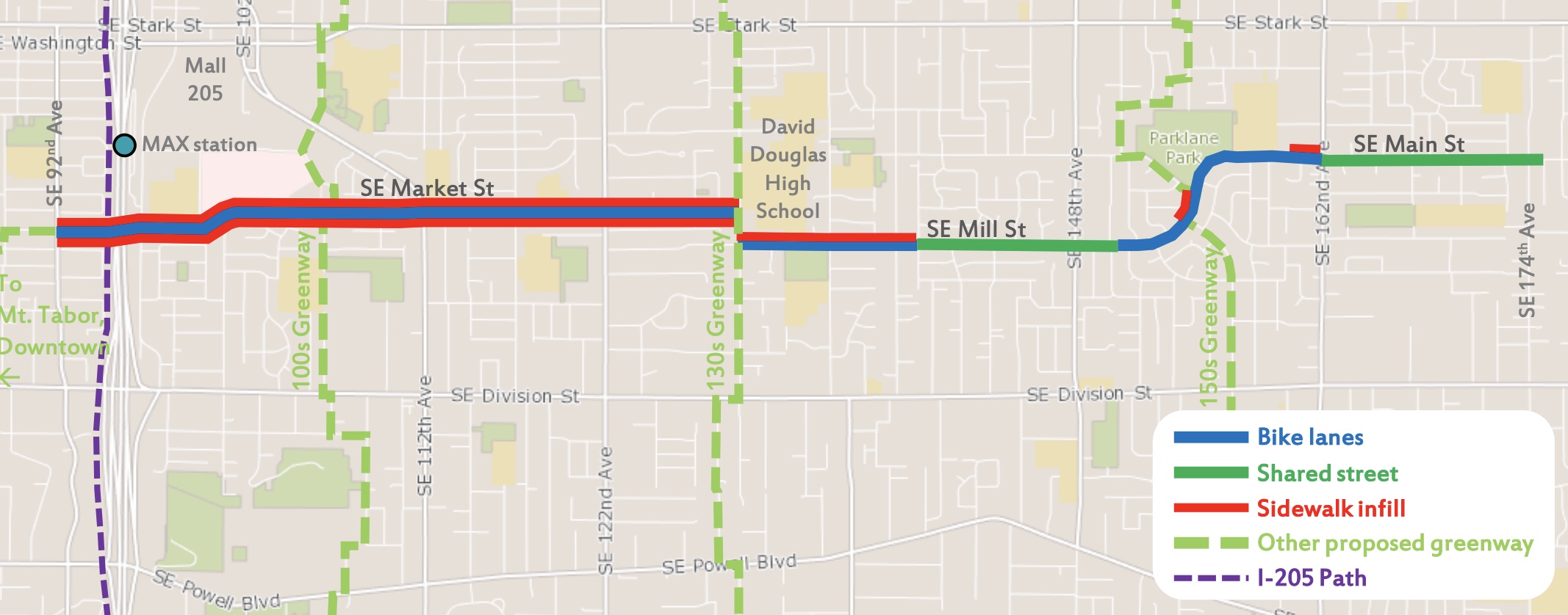
Once completed the 4M Greenway will stretch for 4.2 miles on SE Market/Mill/Millmain/Main between Southeast 89th and 174th (Gresham border) and will be the longest east-west greenway in east Portland. The route is considered a lynchpin in a network of safe bike routes that will provide an alternative to riding on the dangerous and high-speed arterials of SE Division and SE Stark. It will connect the I-205 path to many parks and schools and will intersect with three north-south greenway routes.
Today’s council action will impact the eastern portion of the 4M project, a 2.2-mile segment on SE Mill and SE Main from 130th to 174th (above left). Plans call for a mix of treatments that include speed bumps/sharrows in some sections and bike lanes in others. PBOT will also add some new sidewalks, wayfinding signage, trees and street lights.
Advertisement

The western portion of the project between SE 89th and 130th has been bundled into the $11 million East Portland Access to Employment and Education project. Construction on that project began in December and includes the 100s and 150s neighborhood greenways as well as new bike lanes on SE Cherry Blossom Drive.
Progress on this key east Portland greenway is very welcome news. Since being recommended in the Bike Plan 10 years ago, the project was also part of the East Portland in Motion plan adopted by city council in 2012. But progress stalled when PBOT budget decisions defunded the greenway program a year later. In 2014 the nonprofit Street Trust pushed for its completion and in 2015 the PBOT Bicycle Advisory Committee named it as one of their 10 top priorities citywide.
Moving forward on the 4M is just the latest bit of good news for east Portland. Last year we reported on new connections to the Springwater Corridor path, new bike lanes on SE 136th, the big makeover on at SE 80th and Mill, new greenway connections from the Springwater to Gateway Transit Center, and buffered bike lanes coming to 162nd Ave.
— Jonathan Maus: (503) 706-8804, @jonathan_maus on Twitter and jonathan@bikeportland.org
— Get our headlines delivered to your inbox.
— Support this independent community media outlet with a one-time contribution or monthly subscription.


Thanks for reading.
BikePortland has served this community with independent community journalism since 2005. We rely on subscriptions from readers like you to survive. Your financial support is vital in keeping this valuable resource alive and well.
Please subscribe today to strengthen and expand our work.
It’s odd that a Greenway that “active transportation champion” Novick cut in 2013 is out for bid prior to the 100s and 150s which were funded years prior. If PBOT genuinely prioritized equity, the fully funded 100s and 150s would not have been intentionally neglected for a decade.
Note: the 100s and 150s Greenways would implement significant improvements in infrastructure for pedestrians and people with disabilities on some of Portland’s most deadly arterials.
The 100s and 150s are already under construction! They went out to bid way before 4M. It’s right there in the article.
The link cited in the article confirmed that construction on the 4M had started but there was absolutely no indication that construction for the 100s and 150s has started:
“The East Portland Access to Employment and Education project will build the 100s Neighborhood…”
“Additionally, crews will construct the 150s Neighborhood Greenway…”
https://www.portland.gov/transportation/news/2020/12/15/news-release-pbot-breaks-ground-new-sidewalks-150s-neighborhood
If you have any evidence that these greenways are under construction , I’d be very interested.
“Breaks ground” literally means “under construction.”
So you have no evidence that construction has started on the unfinished section of the 100s and the 150s greenway. Thanks for your help on this matter.
During the EPIM process in 2010-12, we knew that the 100s, 130s, and 150s were all going to be expensive projects and we believed that the 4M, a “signed” county route from the 80s, would be cheap and low-hanging. We collectively prioritized the 130s and 4M to be done first as central spines of an eventual East Portland low-volume neighborhood network, and then the 100s and 150s, then all the other routes afterwards (including the just-completed HOP). The city and Metro had various opportunities to fund projects 2011-14. As community advocates, we correctly thought the city wouldn’t build the 100s, 130s, 150s, and HOP without state funding through Metro, but we clearly made a mistake when we thought that the city “would do the right thing” and complete the 4M using internal PBOT funding. Instead we East Portland advocates did our best to help SWNI get the SW Multnomah cycletrack funded with MTIP. And of course PBOT kept delaying all East Portland bike projects with every lame excuse they could find or invent.
Funny I was just talking with a person who lives in E Portland yesterday and SE Mill came up. The “after” picture shows adding centerline stripes and unprotected bike lanes (and no calming features on those segments??). Is that really a good design? It doesn’t appear to address concerns which I understand include speeding, and more drivers using Mill as cut thru because, increasingly, it’s faster than Stark and Division. Mill has very long straightaways with no speed bumps, stop signs, or other features to prevent dangerous speeds. The City doesn’t show any speed study mid-straightaway. However, even near the stop sign at 143rd half of drivers were speeding, according to the one study I see:
https://pdx.maps.arcgis.com/apps/webappviewer/index.html?id=7ce8d1f5053141f1bc0f5bd7905351e6
Adding centerline stripes won’t help speeding, and will make the street feel more like a major road suitable for driving fast.
Also, Mill is a prime example of where PBOT should comply with the ordinance directing PBOT to post 20 MPH on collectors in residence districts (as they have done in NW). Is that in the works?
Exactly my feeling as well. If PBOT treats it like a major street, so will drivers.
Why not speed bumps and diverters and narrowing drivable space with parking to help bring speeds down to sane levels?
I agree, implementing a 4M without speed humps and a full menu of other traffic calming devices would be the ultimate folly of PBOT. On the other hand, it would be par for the course in PBOT’s relationship with East Portland, alas.
PBOT engineers, who have veto power within the agency, have been told “recently” by the Fire Bureau and surrounding neighbors that they object to any speed humps along any part of the 4M. The fact that such conversations occurred only as recently as 1997 gives you a notion of how out of touch PBOT engineers are in East Portland. When we advocates directly contacted the Fire Bureau, we were told that the PFB no longer uses any streets along the 4M as emergency routes but instead use Stark and Division then cut in, and they have voiced absolutely no objection to speed humps on the 4M on the rare occasions that PBOT has asked them. All the surrounding neighborhood associations are enthusiastic supporters of the 4M and do not recall hearing PBOT asking for their feedback. The only opposition to speed humps has come from the David Douglas and Centennial School Districts who have issues related to school buses, and from cut-through car drivers. When I left East Portland in late 2015, there were existing speed humps on Market between 122nd and 130th. https://www.google.com/maps/@45.5115961,-122.5353248,3a,75y,94.06h,87.43t/data=!3m6!1e1!3m4!1sr3f3Nq4zd8dz81wislI8UA!2e0!7i16384!8i8192
I’m confused as to the purpose of the project. If, as the project description states, the goal is to design a neighborhood greenway as “low-traffic and low-speed streets where we give priority to people walking, bicycling, and rolling,” I see no reason to assume this design will fulfill that goal. Standard bike lanes do not encourage people to bike. When projects are built without measurable goals, how does one measure their effectiveness? How many traffic diverters would $2 million buy? If you are interested in actually making this route prioritize people and not cars I would encourage you to email the project manager: Nicole.Peirce@portlandoregon.gov
PBOT hasn’t done well with measurable goals (25% mode split for bikes in the Bike Plan, 0 traffic fatalities in Vision Zero, etc.), so they’re now focusing on unmeasurable ones (equity) and transmorgifying those into things DOTs and BOTs are good at, such as vehicle throughput (see Hawthorne).
It’s kind of like your New Year’s resolution diet in early February.
Needs diverters.
I love diverters, they work great to remove through car traffic on gridded streets where we want to bike, to streets that are better for car traffic, and they work best when parallel streets are just a block away. It’s too bad East Portland isn’t at all like inner Portland where parallel blocks are just a block or two away, but instead is packed with curvy streets and cul-de-sacs, where the next parallel street is usually between 10 and 30 blocks away (1/4 mile to 3/4 mile).
Where would you recommend PBOT put in diverters and where would you divert traffic to?
Divert it in a big circle.
Potential divertor locations: Mill and 135th. Mill and 140th. Mill and 148th. Millmain and Main. Either divert traffic frequently, or encourage through traffic and build protected lanes. The current project has virtually no benefit other than a few blocks of sidewalk.
I would put “no entry” type diverters (similar to what we have on SE 39th) at 112th, 122nd, 148th, 162nd, and 174th. There are alternatives close by that would allow residents to access their homes. Access from Division and Stark to David Douglas would not be affected.
“Adding centerline stripes won’t help speeding, and will make the street feel more like a major road suitable for driving fast.”
That was my exact gut reaction to the two images. The yellow stripes mean exactly what you say. In the “before”, drivers considering speeding risk car doors opening into their path, bikes on the road, cars coming out of driveways into their path, and cars heading towards them in the middle of the street.
In the “after”, bikes have been separated away from the vehicle lane, car doors open into the bike lane instead of the vehicle lanes, and oncoming cars are separated by the yellow stripe. Every danger to speeding has been removed.
$2MM for 4 miles of painted stripes?
It’s $2 million for 2.2 miles of painted lanes between 130th and 174th, plus a bunch of new sidewalks, and an odd $2,000 speed hump here and there, and probably a flashing beacon or two. The 1.8-mile portion from 92nd to 130th is separate and includes quite a lot more sidewalks, plus more of those retro painted bike lanes, but at a much higher price. I’ve heard it’s $3.5 million for all 4 miles. On the other hand, they are spending $110 million on 4 miles of Powell, so everything is relative.
Does anyone know if the rendering is of a particular location? I’m asking because it doesn’t look like it’s near 131st. The “before” photo has sidewalks on both sides, with room for street trees on both sides. The “after” has no sidewalks or street trees on one side. Why prioritize on-street parking over providing a sidewalk? No sidewalk on one side means people either walk through people’s private yards, or walk in the bike lane, or (if coming or going to a house) have to cross mid-block to get to the sidewalk side.
It’s a stock image from Anytown USA, which on the city project website PBOT uses the same street image to illustrate 3 different types of treatments. Note the lack of paved sidewalks to the house steps, driveway aprons, etc. As far as I can tell, the only places that won’t have sidewalks on both sides are ironically at city parks (it’s up to Parks & Rec to put in sidewalks if they want them). I agree, it’s an odd image for PBOT to use.
Thanks. Weird. Lack of details in a rendering are fine, but showing no sidewalks and finding out (as you said) that it’s a generic rendering makes the whole thing useless–“This is what the design will be, except that it won’t”.
Reading what you said, then looking back at the rendering, I question everything in it. Will the parking lane and bike lanes be that wide, or will the bike lane really be narrow and right in the door zone? etc.
PBOT once showed my neighborhood a cross-section rendering of their proposal for a neighborhood street, which looked perfect until I pointed out they were showing about 45′ of bike lanes, sidewalks, etc. in a 30′ wide right of way. They also shrunk the humans to about 60% scale to make it look achievable.
Renderings are a form of communication that need to be as accurate as words.
The before pic is the actual street as it is right now, but actually about 132nd looking east, DDHS Football field on the left and Lincoln park on the right. I ride this route to work M-F. I was hit and run at 130th 7/21 by a motorist that was in too big of a hurry from the “calming” features on 130th, sped from the last speed bump going North, came to a stop at the stop sign then accelerated once I entered the intersection turning left to go South on 130th. Luckily I was almost past him when he hit me, the hit was somewhat glancing and still spun me around pretty hard, still working through neck and shoulder pain, been off work since aside from a week when I tried to go back. Glad he didn’t get me broadside.
The “calming” on 130th, as with many streets only seems to frustrate many of the drivers who run and gun from bump to bump and stop sign.
I’ve ridden that entire route multiple times, and I thought it was already designated as a neighborhood greenway. The improvements are welcome, but that’s a lot of money for painted bike lanes. I certainly support sidewalks, diverters, speed bumps, and pedestrian crossings if that’s what we get for the money.
I found these streets fairly calm. Just painted lines won’t make much difference to my use of this route.
same! when i lived in east portland, this was my route down to springwater to bike further east into the gorge. i never had any issues, found the streets wide enough, and thought it was already designated a greenway. i’m all for making routes better, but seems like this money could be spent better in other places in east portland?
Putting down double yellow lines basically screams to drivers go faster…. Taking the Lions out actually makes them go slower…
Who let the lions out?
Bwahahah
A bit O/T, but has anyone noticed the change to the Google Maps bicycling overlay? Unfortunately now basically all Portland streets show up as bike-friendly at a certain zoom-level rather than just the designated greenways (or the greenways that were designated some time in the past — not sure how up to date it was).
Unfortunately Google Maps did not do a good job of maintaining the bike data. In the past it was added by volunteers and now it is almost impossible to update.
I would recommend looking at opencyclemap.org which uses free, open data which you can edit at openstreetmap.org
Also the official city map of course:
https://pdx.maps.arcgis.com/apps/webappviewer/index.html?id=b51534aa6e1f4dd4ad4d83c4a084d9a6
Google (and Apple—they should be adding Portland biking soon) should find a way to slurp that data.
I have given up on google maps for a long time for the purposes of wayfinding by bicycle. It is almost entirely useless. Try RWGPS, Komoot or Gaia.