
(Photos: Jonathan Maus/BikePortland)
The Portland Bureau of Transportation announced that they’ll fully close North Greeley Avenue for five days next week in order to complete a project that will repave the street and add a new protected bike path.

This $1.8 million project was first planned over three years ago but has been beset by delays. Greeley is a major north-south artery that provides access between downtown, Swan Island, and St. Johns. It has a history of crashes involving bicycle riders due to the high speed of drivers, lack of bikeway protection, and a horribly designed southbound bike lane that requires riders to merge across an Interstate 5 on-ramp.
In December 2019 a Multnomah County Judge found PBOT negligent for the design and awarded $350,000 to a crash victim to settle a lawsuit.

PBOT’s solution is to build a two-way path on the east side of Greeley between N Going and the start of the existing path just west of Interstate Avenue. A concrete barrier will be erected adjacent to the path to separate bicycle users from others. The two-way path will be 11 to 12-feet wide (with shy distance from the wall, the two bike lanes will only be about 5-feet wide). By comparison, PBOT has increased the width of the adjacent lane to 12-feet to accommodate a high volume of large trucks that access Swan Island.
Advertisement

To access the path, southbound bicycle riders will have to cross Greeley with a diagonal signal at Going. The signal will give bicycle users a separate phase to increase safety.
In a statement today, PBOT said the project will be completed by mid-summer following a full closure from June 15th to 19th.
Hopefully this time it will actually happen.
We were first promised this project in spring 2017; but a city contracting glitch pushed it back a year. Then it was supposed to be built last summer, only to be delayed again. A PBOT sign posted near the project a month or so said construction would be done by February 2020.
Advertisement
Suffice it to say we’ll believe this project is done when we see it. And we remain skeptical that two-way bike traffic (one direction going fast downhill) sharing 5 to 6-foot wide lanes will provide an adequate level of service for bicycle users. Here’s to hoping!
If you use Greeley, alternate routes are Interstate or Mississippi Hill/N Michigan Ave Greenway. Learn more about this project in our archives or at PBOT’s website.
— Jonathan Maus: (503) 706-8804, @jonathan_maus on Twitter and jonathan@bikeportland.org
— Get our headlines delivered to your inbox.
— Support this independent community media outlet with a one-time contribution or monthly subscription.


Thanks for reading.
BikePortland has served this community with independent community journalism since 2005. We rely on subscriptions from readers like you to survive. Your financial support is vital in keeping this valuable resource alive and well.
Please subscribe today to strengthen and expand our work.
I wonder if it’d be possible/legally expedient to sue PBOT for negligent design *before* a tragic crash happens. Then we can donate the money back to them on the condition that they design a proper facility. Any lawyers want to talk?
You have to show damages to make out a claim of negligence. Damages would require physical harm (while emotional distress is recognized, the other elements of an E.D. claim couldn’t be met under your hypothetical). So no, it’s not possible.
The lead image of the cross-over at Going looks like the result of bad planning.
https://www.portlandoregon.gov/transportation/article/744139
Indeed. Why not move the jersey barriers to include the bike lane? Can’t understand the reason behind PBOT’s design here.
I could see myself using the downhill bike lane if there wasn’t much traffic.
But if I was riding with a friend I would want to take the lane so we could be side by side. On the path you’d have to weave when there’s oncoming cyclists.
The downhill bike lane looks OK if you are ambling slowly with friends and family, but it’s not a quality commuter corridor.
It should succeed in making motorists even more mad when a commuter cyclist takes the lane.
You would take the lane uphill on a multi lane street where traffic goes 50+ miles per hour? Just to ride side by side? I have a feeling you are not the “design rider” for this or any bike project.
No, and no. I did not mention uphill at all. I mentioned downhill, twice, so not sure where your comment is coming from.
But since you’re asking, I would avoid biking up this.
Do you only ride your bike down hills? How do you get home?
When my dad was a kid, he had to ride uphill both ways. It looks like Johnny Bye Carter has found a better way.
“How do you get home?”
Williams–>Ainsworth–>Willamette between the fall time change and Memorial Day.
Interstate–>Alberta–>Willamette otherwise.
No 10 yr olds nor 70 yr olds will ride Greeley more than one time unless they are lost.
This is definitely a commuter route. It’s not bad for getting you where you’re going but there’s nothing above or below the section of interest — it’s junk riding by a rec perspective. Even after the upgrades, it still won’t be noticeably more fun than Interstate.
Will be interesting to see how this works out in practice. Downhill traffic, debris, and homeless all strike me as wildcards — especially after the weather and the darkness returns.
Greeley is the westernmost n/s bike connection to North Portland. This could be a showcase for an all ages bike route. I do not understand why PBOT is treating this section of Greeley , less than 2 miles, as a mini freeway. Traffic could be slowed, and the access ramps could be urbanized so they are not treated as extensions of the freeway.
If by “showcase” you mean something to show off with no practical use, I agree on the all ages thing. That does have a real Portland sound to it.
People on the hill can take their kids (some of which will have control issues) down a narrow path by a highway and rail line to an industrial area. Those down below can go up a hill that many kids and adults will struggle with (if they can handle it at all) to a bunch of busy streets and boring neighborhoods.
The only real problem with the section right now is the I-5 merge is genuinely dangerous. Slowing things way down in that area to 35mph real world driving speeds or less and/or putting a beg button and stoplight for those who don’t like interspersing with traffic would go a long way to improving that.
We’ll see how this plays out. I’m not holding my breath.
I live in the boring neighborhood, riding past the railyards is interesting, and getting beyond them connects to downtown and Central Eastside and most of Portland, so hardly a dead-end.
When I first saw the photo…I thought PBoT had done a COVID Open Streets conversion of the 4 MV lanes into a bike and ped facility! 😉
Will this be completed before or after the Off Road Cycling Master Plan?
Everything will be complete before the ORCMP is even started. I say we just start cutting new bike trails in Forest Park.
Almost certainly.
A previous post on this project showed this image, with a concrete barrier between the cycleway and the rest of the roadway: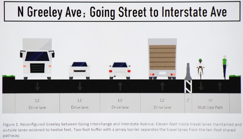
Is that correct, or is the new picture with plastic posts accurate?
great catch Joseph E! The concrete barriers were touted as the sole benefit for bikes- now that they have been scrapped maybe we can get some organized opposition to his crappy project.
The PBOT site says “continuous concrete barrier” in multiple places. So the new graphic is presumably (hopefully) in error.
This is a horrible project that claims to be provide bike facilities but really is ONLY for increasing the speed for freight haulers, that is why the lanes are being widened to 12′ and 13′! The average speeds are already in excess of 55 mph, yet the project is doing nothing to reduce speeds despite a family being killed in their minivan on this very stretch of road. PBOT is claiming to be building a MUP, but is striping (2) 5′ wide bike lanes- where are pedestrians and joggers supposed to go? What happens at the existing path (which makes up 1/3 of the distance of this route) which is less than 10′ wide, passes through a homeless camp which has as many as 4 personal vehicles being used and is serviced (water, portapotties, trash) regularly with large trucks using this path? PBOT has ignored every single one of the well known safety issues for people driving , biking or walking and are pressing ahead with this half-baked design. All of these delays should have resulted in a much better and more thoughtful design. The status quo is better than this- I am so disappointed.
The article about the lawsuit is really interesting, particularly the part where the an important basis for the claim was the quantity of complaints about this conditions. It is never too early to start alerting PBOT to known deficiencies in their design so that if someone is injured, they also will have recourse. For this design, I would ask PBOT to address the following deficiencies:
1. not addressing high speed through speed limit reduction AND narrowing the traffic lanes.
2. Constructing a MUP that is substandard in width.
3. connecting a 2-way MUP to an existing walkway that is less than 10′ wide without making any improvements such as widening.
4. Directing pedestrians to use a facility but then striping it as a 2-way bike route. Pedestrians need a dedicated space to travel safely
5. Routing 2-way bike traffic down a single curb cut where this new route connects to Interstate Ave.
6. Creating a bike route down what is functionally a City-sanctioned driveway. The city has allowed the Hazelnut Grove to operate and store as many as 4 personal vehicles and this path/driveway is the only access. This path/driveway is also used by large trucks to empty dumpsters, fill a water tank, and service the portable toilets. Currently the City does not close the path when it is used and blocked by these large flaggers at Going and Interstate Ave whenever the route is closed.
I recommend submitting concerns here:
PDXRoads@portlandoregon.gov
Nicole.Peirce@portlandoregon.gov
Don’t forget
roger.geller@portlandoregon.gov
chloe@portlandoregon.gov
mayorwheeler@portlandoregon.gov
I am going to miss the fast rip down Going Hill, it is one of the best in Portland. Now you will have to stop and diagonal across Going, then resume your ride downhill into the face of slow, uphill bike traffic on one side and oncoming vehicle traffic on the other. All this on a narrow, sub-standard MUP “protected” by PVC pipes. Throw in some pedestrians and this is a recipe for disaster. Put me down for a NO vote.
Not only pedestrians, but unregistered and likely stolen vehicles that are regularly stored and driven on the MUP.
Greeley is on my daily route to commute into downtown from my home in North Portland. But I never ride northbound on Greeley because I have absolutely no interest riding through the Hazelnut Grove camp. Instead, I bike a mile out of my way to take Williams and Rosa Parks. And that is under current conditions, when the narrow path through the camp is not regularly being used by 2-way bike traffic.
When this bike route is completed, I will NEVER use Greeley as a bicycle route again.
PBOT, why are you ruining a route that is designated as a MAJOR CITY BIKEWAY
in the city’s own transportation system plan? You are making this street unusable for cyclists.
Good luck, my fellow riders, of seeing anything, when we share the 2-way cycle path in an on-coming direction on some late fall evening commute – one travelling fast downhill, the other slowly uphill. My 200-lumen headlamp will blind you for many seconds. And your light will, in turn, blind me. We can share a room at the hospital, together.
Perhaps we will have courteously turned our headlamps off or pointed them judiciously to the street, but the on-coming car and truck vehicle headlamps in the near lane will blind the down-hill rider, anyway. Maybe, you will be one of the two-abreast cyclists travelling together in the lane – one will have a bright light on, the other nothing, resulting in total lack of visibility of the unlit cyclists to all on-coming bike traffic rolling down the hill.
Two-way cycle paths, especially adjacent to car-lanes, are unsafe at night due to the over-lit and directly facing conditions of bike and car headlamps – blinding all on-coming cyclists.
This will be especially pronounced because, if my understanding is right, it will be the downhill cyclists who will be both 1) traveling very fast; and 2) blinded by the car headlights.
If protected (safe) and practical (direct/networked) bike infrastructure were a priority for PBOT, this would have been built in 2010 when the npgreenway was imagined. Here’s a reminder:
http://npgreenway.org/
Remember Amsterdam looked pretty similar to Portland in 1970, and Vancouver looked similar to Portland in 1990. The only reason why those cities have had an enormous increase in bike share is: protected bike lanes. We’ll get there eventually.
“We’ll get there eventually.”
I doubt it.
If this is what protected bike infrastructure is going to look like in Portland, I don’t want any of it. I love protected bike lanes. But what is going to be built on Greeley is garbage.
While I understand your sentiment, keep in mind this creates a jersey barrier protected bike lane for the longest distance PBoT has built to date. There’s less than 5 miles of PBL in Portland if you’re very generous. (For perspective NY is putting in 30+ per year). We can be vastly disappointed by a long history of shitty design by PBoT, but at least this one is an actual PBL. Once PBoT builds the skeleton of a practical PBL network, Portland will transform.
I cannot understand why you are excited by a length of barrier-protected bike lane that is unsafe, too narrow and has a seriously deficient connection for 1/3 of its length. This bike lane will improve Portland’s statistics, but it trading one set of problems for a new set of problems, keeping the bike route unsafe and making it less convenient. the project ignores the unsafe driving conditions or makes them worse with wider lanes and ignores pedestrians by striping this cramped facility as a 2-way bike path. I am seriously asking why do you think this is good thing? IMO, we need protected bikes AS A COMPONENT OF safe and direct routes while creating Vision Zero streets and providing space for pedestrians. This project creates protected bikes lanes INSTEAD OF addressing the street, proving for pedestrians or creating a safe or direct route for people biking.
I’m going on the assumption that the original design will be implemented, ie jersey barriers with a 11.5′-12′ physically separated path.
So here are my issues with that: the route from the Greeley/Going to Greeley/Interstate, the proposed cross section of 11.5′ for an MUP is very narrow. This is the entire width of the path, there are no additional shy-distances (the unusable space immediately adjacent to the vertical concrete barrier) or shoulder. If it is striped down the center, it is 5.75′ wide in each direction(not including striping). This is a very narrow path for a bike to share with a pedestrian. If we include a very conservative 1′ shy distance, 6″ for a center stripe and 6″ for a an edge stripe/shy distance from the shoulder, the useable space shrinks to 9.5 or 4.75/each direction. Furthermore, this cross section only lasts for 2/3 of the length of the route.
The southern 1/3 of the route is along an existing concrete walkway that is just under 10′ wide with no shoulders. Since there is not barrier, there is no need of a shy distance, but the edges are soft grass/mud in the winter, so there is no extra room. Once again, the lanes will be less than 5′ wide in each direction, not enough space for bikes and pedestrians to share.
Next, look the connection. Northbound Greeley bike traffic currently follows Interstate under the Greeley overpass, and uses a beg button/signal to cross Interstate and ride up on to the sidewalk using a curb cut. The new design will now add southbound bicyclists USING THE SAME RAMP AT THE SAME TIME. The s’bound riders will have to descend the ramp and make an immediate right turn into a 5′ wide bike lane while merging with bikes coming down the Interstate Hill and adjacent to fast-moving traffic or compete with northbound cyclist using the signal. PBOT has confirmed that they are making no improvements here- this is the plan!
Adding to the fun is the fact that existing concrete walk is used as a driveway for multiple vehicles in the Hazelnut Grove camp and by multiple large vehicles (trash, water, portable toilets) who close the path completely without warning/notification or providing an alternate route.
As Jonathan notes, this project has been delayed for years, they have had ample time to address these issues. The issues have been raised repeatedly, so they definitely know about them. A mother and daughter were killed in their minivan here while this project has been waiting to be built, and yet they have done nothing to revise plans to address the known speed issues this road has.
Finally, what about convenience and directness? not as important as safety, but still vital to successful bike route. I already described the southern intersection with Interstate, but check out the intersection with Going. Instead of rolling down the hill as they do now, southbound cyclist will have to wait for a long light, then use a novel diagonal crossing hoping people driving in excess of 55 mph in each direction will stop in time, all to travel out of direction to use a too skinny lane!
All valid criticisms. PBoT is not known for prioritizing bikes/people in their designs. Car parking and speed is their priority. That sucks. But it is safer than riding on a de facto freeway which is the status quo.
The path is already impinged upon by over grown vegetation, illegally stored and operated motor vehicles, and wooden utility poles that are planted right in the middle of the path. I’ve neither seen nor heard any commitment to remedy the problems that already make the path practically unusable in the stretch that passes through the homeless camp. If these conditions do not improve, all the Jersey barriers in the world along the stretch of road that is not next to the homeless camp will not make this a safe or attractive bike route. The only reason that the south bound bike lane is usable at all right now is that it doesn’t go through the narrow stretch of trail next to the homeless camp.
I’m still unclear on the need for four lanes on this section of Greeley. Maybe just in the uphill direction approaching Going, but nowhere else. Over-dimensional (width) loads could still be accommodated with narrow low medians to separate opposing traffic lanes. Considering the speed people drive out there, any centerline cross-overs would likely result in severe or fatal crashes.
Agreed. Why no median? Why 4 lanes? Are they attempting to accommodate freight?
IMO they are absolutely compromising for freight users. Not only is PBOT very attuned to freight interest demands but this project was partially funded by Heavy Vehicle Use Tax so they are being even more careful to make sure it meets freight lobby demands.