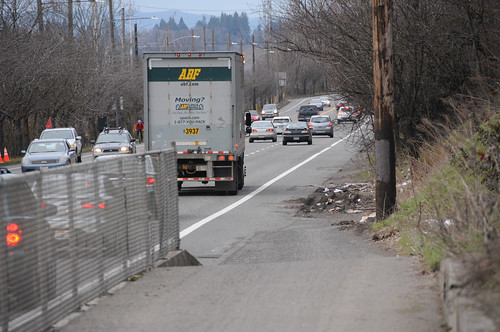
(Photo: Jonathan Maus)
Bicycle users will have to endure stressful and dangerous conditions on North Greeley Avenue for another year because the City’s plans for a physically protected bike lane have been delayed.
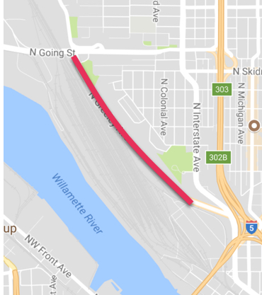
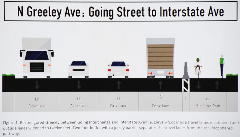
Back in February we reported that the Bureau of Transportation planned to update this stretch of Greeley between Going and Interstate by adding a 10-foot wide, bi-directional path separated from motor vehicle traffic by a two-foot wide concrete barrier (see proposed cross-section below). The barrier is needed because a recent PBOT speed analysis showed the 25,000 motor vehicles on the road every day are driven at freeway speeds — about 56-59 miles per hour on average.
Greeley makes an important connection between downtown and north Portland neighborhoods from Arbor Lodge to St. Johns.
Today there’s nothing more than an unprotected, painted bike lane in both directions. To make matters worse, the southbound bike lane crosses over an on-ramp to I-5 with nothing to slow people down. In February 2016 a man was hit at this location and told us his, “Now, just the thought of riding to work makes my heart pound… If I’m not actively doing something that occupies my immediate attention, my thoughts drift back to that morning: realizing in that moment that the car is not going to slow down, careening off the windshield, screaming ‘no, no, no’ as I hit the pavement, my bike crumpled beside me.”
Classified in the 2030 Bike Plan as a “major city bikeway,” Portland’s bike coordinator Roger Geller said in Februar he was confident the new protected bikeway would be in place by this summer at the latest. The project is fully funded and the plan was to tie it into an existing repaving project. In an email on May 30th, Geller told a BikePortland reader that it would be built “this summer… likely around August.”
Advertisement
Unfortunately that won’t happen. The buffered bike lanes in the northern section between Going and Killingsworth (past Adidas headquarters) will still happen this summer, but the much-anticipated, concrete-barrier protected section between Interstate and Going has been delayed.
Asked to explain the delay, PBOT Communications Director John Brady said it has to do with state contracting laws. “We’re limited by state law about how much construction work we can do in house,” he explained. “Our projects staff decided that doing both the paving project and the bikeway project in-house could possibly give the impression that we were exceeding the [legal] limit of $125,000. So they decided to contract the Going to Interstate portion out and the contracting process adds time and pushed the project out until next year.”
Brady is referring to an Oregon Revised Statute 279C.305, “Least-cost policy for public improvements.” That law, which was amended with the passage of House Bill 3203 this legislative session, states that,
“If the contracting agency [PBOT] intends to use the contracting agency’s own equipment or personnel to perform construction work on a public improvement, and the estimated value of the construction work that the contracting agency intends to perform with the contracting agency’s own equipment or personnel exceeds $200,000, the contracting agency shall file with the commissioner not later than 180 days before construction begins on the public improvement an analysis that shows that the contracting agency’s decision conforms to the policy stated in subsection (1) of this section.”
Subsection 1 of the law says that the contracting agency, “shall make every effort to construct public improvements at the least cost to the contracting agency.”
This is an unfortunate turn of events for a project that we needed yesterday. I’m still not clear why PBOT didn’t see this coming before they decided to delay the project. I’ve followed-up with Brady to find out and haven’t heard back yet. I’ll update this post when I know more.
Bottom line is we don’t have safe bicycle access on Greeley. And we won’t have it until next year.
— Jonathan Maus: (503) 706-8804, @jonathan_maus on Twitter and jonathan@bikeportland.org
BikePortland is supported by the community (that means you!). Please become a subscriber or an advertiser today.


Thanks for reading.
BikePortland has served this community with independent community journalism since 2005. We rely on subscriptions from readers like you to survive. Your financial support is vital in keeping this valuable resource alive and well.
Please subscribe today to strengthen and expand our work.
Because of course it was.
And every supplier on both coasts is out of orange cones until next year or we would have cordoned off a lane by now.
EL,
The change involves a 5-6 foot west shift of all lane striping to provide the protected east side space. Cones won’t do the job.
Maybe they will come to their senses create a real fix rather throwing away money on this half-assed “solution”. A bi-directional MUP forces bikes to cross this very busy road twice adding a ton of time and inconvenience to people’s trips. 10′ is far too narrow for a path where people heading downhill can easily exceed 25 mph. This route will definitely be used by people with shopping carts and bike trailers with huge loads. This is also an opportunity to fix the gap in the walking/jogging network here and this path is too narrow to do that.
PBOT need to suck it up and fix this broken street. We need a protected bike path and sidewalk northbound and a protected bike lane south bound on the west side of the street. Building this is simply throwing away money. Portland’s compromises can go too far, and this is an excellent illustration. We need the fix, this is clearly dangerous, but their proposal is pathetic and lame. It also connect to Interstate on a skinny little MUP that is used as a driveway by the people in Hazelnut grove and for regular servicing of the porta-potties and giant dumpster so get ready to have the path completely blocked by cars and large trucks with no where to go.
I agree. I avoid, and will continue to avoid after this path is built, Greeley on my commute to and from work. It is also, by far, the most direct route for me to use on my daily commute. I wish they would have come up with a better plan than this.
Why would you have to cross twice? The MUP intersects with Interstate on the south end, so you would just make a right onto Interstate and continue south.
You still have to re-cross Greeley on Interstate and it is a long light.
Therefore it is long light for EVERYONE. Are bikes so special that they cannot wait like everyone else?
People driving south on Greeley avoid this. I think bikes should be able to take a similar route to people suing cars instead of directing them out of their way and adding additional signals. Clearly, bikes are not speacial at all because it is the defacto planning and design practice to route bikes along circuitous routes, ask them cross busy roads without signal and navigate uncoventiaonal, ever-changing infrastructure (like switching from a bike lane to a 2-way path on the wrong side of an arterial, then to an off-street MUP/driveway, then back to bike lane.
When Portland Parks did their alignment study, this was identified as the least desirable choice , with an alignment along the west side of greely, or most preferably, the Cement Road through Albina Yard. There was discussion about vacating the closest to Greeley set of tracks in Albina Yard. The City was doing an analysis, I don’t know what became of that possibility.Union Pacific RR has been completely unwilling to consider the Cement Road.
My guess is Parks ( why did this become a Parks project, vs PBOT?) probably wants to see this (North Portland Willamette Greenway Trail, the signature trail demanded in the 2030 Bicycle Master Plan) in the ‘done’ column asap. Whether its the truly ‘signature’ trail or a ‘good enuff’ trail hinges on how difficult choices are made.
I’m reluctant to use the east side Greeley path because of the folks living there. I know I’d hate it if people rode through my bedroom at 6:00 am.
This is the first I’ve ever heard of this law. How is this not simply a handout to big contracting/construction agencies? How much more infrastructure could PBOT build if they weren’t limited by this law?
If PBOT is using any state or federal money for a project, they are bound to state and/or federal rules, even if a majority of the funding is local. In years past, $125,000 was the limit for internal projects, so the $200,000 stated is an improvement. If the funding is entirely just PBOT, without even a penny of state or federal funding, then PBOT is bound by city rules only, where there is no real dollar limit. Clearly PBOT will not do Greeley without some state or federal funding.
“Where there is no real dollar limit.”
Tell that to the union that represents maintenance employees.
DH,
Show us where the state law only applies to Federal or State funding.
I’m out of my depth on funding conditions, but my read of the referenced Oregon law doesn’t prohibit PBOT from doing projects over $200,000 in house, just that if PBOT does do so, it needs to submit an analysis to the state 180 days before the project begins showing that the in house work is the “least cost” to PBOT and then the statute says what needs to be in the analysis.
Assuming project managers / estimators are on PBOT staff, my question would be why not just prepare the analysis showing in house work is least cost as a regular part of project planning? Seems like a pretty clear cut rule.
Standard Operating Procedure on all government grants, spelled out to me succinctly by a lawyer here. You want grant money? Then you have to abide by the terms of the grant. Really, paikiala, you of all people should know better.
No clue where you went with that answer. The Oregon law says nothing about source of funding changing the least cost requirement.
I simply asked if you had a source you could provide for the opinion that the law only applies to Federal or State grants and not to City-funded (other tax payer) projects.
I do have a source, I keep it in my Greensboro Transit Authority binder, including Federal statutes, NC laws, and local laws. I used to have the similar ND and Minnesota law statutes, and I’ve seen the Oregon statutes. If you had been another volunteer like myself and had asked for them, I’d have given you the citations. However, you have given us the impression that you work for a public agency, so I suggest you view this as a golden opportunity to visit with your department’s legal staff and ask them about grant regulations for your projects. I have no doubt you’ll find this enlightening and stimulating. I also have no doubt that others on this blog find it a dead bore.
The silver lining here is that PBOT does not seem to have any road paint available right now. So they wouldn’t be able to complete the project anyway since it would likely require some markings on the roadway.
There are few things as terrifying as realizing that the cars around you have no clue where they are supposed to be (as opposed to the usual disregard of that knowledge). Still disappointing any time a much needed project is pushed due to easily anticipated circumstances.
D,
Well, PBOT could pay all the costs to remove the current striping (not cheap) and shift all the striping west 5-6 feet, and then grind it off next year and redo it all over again, but I suspect most tax payers would call that a waste.
Except for the aforementioned lack of paint that would be possible. PBOT simply does not have road paint as the supplier had a warehouse fire.
If you want to see what a road looks like without paint check out Beaverton-Hillsdale between Capitol Hwy and SW 45th. It’s quite challenging to know where you’re supposed to be regardless of mode as it’s been weeks since the original guidelines were put down. Everything is fading away except for the bike and ped symbols
That’s nothin’. Oak street was without green paint for 10 months.
I’m rather surprised that PBOT would use paint at all, and not thermoplastic. But even so, that they would be dependent upon a single supplier, as there are so many nationwide.
As someone that uses this stretch of road to get between my home in St Johns and office in Downtown Portland, this is upsetting.
just get rid of the prevailing wage on some of the job, they would save a ton of money…
What, like the wages of people who do real work haven’t been driven down far enough already? Prevailing wage means more locals keep the money in the area to spend at businesses the rest of us own.
Not necessarily. Given that it is a large contract, they have to get a bunch of bids, and the cheapest may go to an out-of-state contractor (from Washington, for example.)
Any contract let would require the contractor to pay prevailing wage so that the playing field is level for local contractors.
strike two?
Paikiala, you probably have access to who was used for various city contracts, or know someone who does, so why don’t you report to us the process of how companies are selected and who has been selected in the past, and from what city and state they are from? Can you do that for us?
I think what Paikiala is referring to is that, as the work would be done here in Oregon and it’s a government job, prevailing wage rates would need to be paid no matter who is doing the work.
Oregon has a fairly decent website for contractors and prevailing wage rates, I encourage people who are interested in it to do their research.
Strike 1
Strike 2
Strike 3
I wasn’t aware that this was a baseball forum, I thought it was for information sharing and discussion. My mistake.
I was waiting for some steel to get sawed at a vendor in North West Portland and read a book they had on the coffee table about the Lewis and Clark Exhibition of 1905. I was stunned by the fact that the entire thing, which included a Lake, An Island, Giant Ornate Buildings and a Grand Staircase was constructed in less than 4 months by workers with hand tools. Not sure what direction our civilization is heading if it takes a year and a half to construct a simple bike lane. Maybe it would speed things up ( and improve safety) if as soon as we designate a street for improved bike transit that street is closed down for automobiles until the bike improvements are complete.
B,
False statement ‘takes a year and a half to construct…’
When was the last time you planned, investigated, designed and constructed anything costing over $125,000 with public funds and critics.
2012/13, East Portland sidewalks along Glisan, 162nd, Stark, etc etc. all designed and built within a 12-month period.
Infilling sidewalks is not a heavy design process. All the work was done by contract and did not involve any right of way acquisition. It was a soil removal, rock placement, form and place concrete project. About as simple as they come.
strike three.
Nevertheless, we were told by PBOT staff that it did go through design review, that many of the small retaining walls, sidewalks, and ADA ramps were extensively designed. Could you contact the project manager(s) to find out what they did? Thanks.
B,
Let’s follow the logic of your last sentence a bit.
You would propose that people driving be deprived the use of roads they helped pay for because another mode of transportation was identified for use along the same pathway in an ideal future (the TSP is an ideal future goal).
Replace ‘driving’ with any other method of travel and you would suggest this scenario is unjust, I presume.
Unjust is unjust, regardless of choice of transportation, or past practice.
Delaying people from causing death and destruction on one road while destroying the future habitability of the planet with their petro powered personal motorcars seems unjust in the same way that depriving Genghis Khans mongol hoards from sacking villages on the Asian Steppes would be unjust to good old Genghis.
We could just limit the number of children people have.
Or build infrastructure for vehicles rather than for people. People are way over-rated anyway.
I’m not particularly looking forward to this work being done. It is true that the traffic is fast and heavy here. However, it’s actually quite safe due to good sight lines and lack of features that cause unpredictable behavior. The lone exception is the I-5 ramp which is tricky and can take awhile to get through if you get pinned.
The million dollar question is what downhill riders will do once it goes bidirectional. That’s too narrow to take at speed particularly since speed differentials will cause a lot of passing with uphill traffic, but I’m betting a lot of riders will anyway.
The other question is whether the full separation will cause any other new noncycling activity on the path. Too often, fully separated infrastructure draws in elements that make the area unattractive for riding. If that happened there, the detour is long.
Well, see the 205 path on the Glenn Jackson for an analogy to this. It’s all uphill from Oregon to Washington, bi-directional, and the only issue I’ve had is with debris from the incredible number of motor vehicles on your left and right. So, I don’t see the bi-directionality as being an unforeseen issue.
Hey everyone looks like this area isn’t actually a stressful or dangerous spot to ride… weird how we all got confused. Fortunately Kyle, who has also spoken in the past about his riding on freeway shoulders, clearly lets us know how unfounded our discomfort is.
Hey Brad,
Do you actually ride here? The I-5 merge is dicey for real when the traffic is thick and fast, but you have way more clearance from vehicles than most roads and no hook threats.
I’ve only ridden the 205 path referenced once and that was a few years ago, but my recollection is that the speeds you can hit there are no where near what you can attain on Greeley, bike traffic is light to nonexistent (I’m guessing the few cyclists out there are more seasoned/sensible), and there aren’t issues with “campers” right along the path.
This separation also comes with a cost. The I-5 merge gets taken out of the picture which is good, but you also wind up with a longer path that takes you through a light.
Going southbound (downhill) on Greeley and on Interstate, a cyclist can easily reach or exceed 30 mph. At those speeds, you really don’t want to be trapped in a 10 foot wide walled lane with two-way pedestrians and bike traffic )plus carts and trailers from the homeless camp, until the camp is removed).
I do sometimes ride here (commuting from North Portland to the Lloyd District) and most of the time I regret it, deciding that saving 5″ is not worth risking bodily injury. Going southbound, the trucks from Swan Island often ride quite close to the bike lane line and I fear one drift from a glance at a text and I’m out. The trees are not always trimmed such that those of us on more upright bike styles have to duck to avoid them (or ride too close to the left of the lane/traffic). During the rainy season, the bike lane has deep puddles that push riders too far to the left, where we get drenched from spray from the cars. Overall, it’s a lovely fast route mid-day in the sunshine, but the rest of the time it’s one to avoid for me. I don’t love the proposed design but I’d welcome alternative. In the meantime, I’ll keep taking Ainsworth out to Michigan where it’s slower but much less stressful.
I’ve ridden this a number of times, although on road rides, not in a commuting sense so I doubt I got a good feel for the daily commute vibe of this spot. That said it was doable in a group and I agree that a two way path would not be a good solution given speed difference NB vs SB. I will say that the I5 merge even in weekend morning traffic was likely the worst point on the ride each of the times I’ve done it.
I was merely pointing out that although you can list the reasons you feel the road is safe despite “fast and heavy traffic” that is obviously not the opinion held by most and that many people who would like to use this route but don’t obviously don’t feel safe in this area despite some of the features you mention.
Kinda like the Foster Streetscape – “it’s delayed until next year”. Next year we’ll hear “it’s delayed until next year”.
Shoot, did it get delayed again again?
Delayed until 2018 now. The explanation is super-convoluted.
https://fosterpowellpdx.com/2017/04/12/foster-streetscape-timeline-gets-a-new-wrinkle/
Delayed by environmental review and design changes as a result, in this case. Environmental review takes an average of 3 years nationwide, with some states taking as little as 1-2 years, and others, like here in NC, 12 years! You can’t build anything anywhere using state or federal money without doing the process. The ‘environment’ includes the biological (plants and animals), hydrological (water run-off), and human (location of minorities and poor.)
Nothing would persuade me to cycle on this street without a physically protected bike lane.
Does that mean you take Interstate now? The speeds on Greeley are higher in that section, but you’re closer to traffic on Interstate plus there are a lot more cars going through the bike lane.
No, when I am heading downtown from North Portland, I hit Willamette, N Ainsworth and then N Vancouver (using N Williams for the return). I find this route to be much safer than either N Greeley or N Interstate, notwithstanding that it may take longer.
I’ve taken that routing a number of times since errands often take me that direction, and I notice that Google recommends that routing for my commute (though it sends me up Rosa rather than Ainsworth, but they’re similar enough).
I know that’s supposed to be safer, but I consider it less so due to unusual configuration, a wider variety of side threats, and a visually busy and less straightforward environment.
I used to use Rosa Parks, but I’ve found Ainsworth has a lot less motor vehicle traffic on it, fewer stop signs and traffic signals, and a lot less detritus in the roadway. I understand your point about the unusual traffic arrangements, particularly with the bike lane on the left on N Williams, but I still prefer it to N Interstate.
Mr Geller said on Twitter that the reason for the delay was that they were “rescoping.” Was that just a made-up answer?
https://twitter.com/Why_Not_Bikes/status/885305112477827072
No, it’s a good reasonable response. They got new data and need to adjust the design; they did environmental review and changes were required; the local match for this project was needed for some other project, so priorities shifted – all of these are common reasons that also happen to be usually true. When you get these events in your project timeline, you then go back to the drawing board and “re-scope” the project: Can we make the changes needed? Do we have enough money? Will City Council/the PBOT Director/BP readers support us?
Interesting. The northern part of MLK is part of our official bike network, on an unprotected shoulder, and the speed limit there is 55- 10 more than Greeley. Are there plans to put a barrier there as well?
Seems Greely could be dropped to only 2 lanes plus a center buffer which would give lots of room for protected bike lanes each way. Although I’m sure it’s a freight route and needs some ridiculous minimum width (eye roll).
Doubtful that a lack of space on Greely itself actually contributes to auto congestion. Ramp onto I-5 and turn onto Interstate are always going to dictate traffic on this route SB. Having merges onto/off Greely coming from / leaving one lane would also help with thru bike traffic. Continuing on a dedicated lane vs having to turn, yield and merge with or out of a lane puts the onus on cyclists to cross rather than cars passing through cyclist space. Although maybe a left handed bike lane heading SB would be best.
I agree. The tricky park is adding a safe bike out around the I-5 ramp. There is space, but it abuts UPRR land and there are grading considerations and existing trees. to either preserve or mitigate. It is not as simple and it is not as cheap, but it is an effective, long-term solution that provides a simple, safe and direct connection (unlike what are proposing to do)
BW,
don’t forget the I-5 ramp onto Greeley. safety dictates a long taper merge for such skewed entries.
Cyclists don’t cross there though… unless you turn onto the shoulder of Greely from interstate instead of using the path north of the offramp.
Could that be restriped/reconstructed to eliminate the ramp and create a stop, then turn right condition to access the ramp? Just looking at Google maps there doesn’t appear to be enough space to get the large raadius turns that would be required for truck traffic. I guess my point is that I dislike the free-way style ramps in cities. Maybe another solution could be closing the ramp? Swan Island has excellent access to I-5 using Going. This would also allow the closure of the ramp from eastbound Going to southbound Greely and free up a lot of space for a protected MUP that could potentilly run under Going (heading north) and along the base of the bluff (or part way up) around Swan Island. This would a create a separate, safe and beautiful off-street trail that is river-focused, pleasant and direct.
BS, knock a hole in the wall at the south end of Greeley and pave a connector to the Interstate bike lane around the right hand side of the freeway onramp.
https://www.youtube.com/watch?v=yPPsSeDR_iI
Interesting idea.
On Google Maps the Real Estate is there for this idea to work.
https://goo.gl/maps/ik3c8NfaipA2
On http://www.portlandmaps.com, it appears that all the land south of the concrete crash barrier is owned by the Union Pacific.
But, since it’s only a patch of weeds in the entire area of concern, maybe they’d give PBOT an easement on it…
Ted Buehler
I hope they re-design this plan completely, with the primary intention to keep a fast, direct, bike commuting route (not to create a linear recreational park). This should include bike-mode-first, bike-specific design for the hill (very different bike speeds require frequent passing), the road debris (saying that they will perform periodic maintenance and street sweeping is a clear joke), and the Hazelnut Grove camp. Current design incorporates none of this – just creates one trade-off for another. I cannot support current design.
I’m still not entirely sold on the merits of this.
For Swan Island workers it would be a huge safety improvement, as it would take out the suicidal lane crossing at the I-5 southbound entrance at Greeley. This alone makes it worthwhile as a project.
But, for North Portland to downtown commuters, it might not be an improvement at all. As someone pointed out to me in the thread a couple months ago, the time it takes for southbound bicycle traffic to make the left hand turn at the Going overpass to cross the road, and potentially wait for a green signal again at Interstate and Greeley, is comparable to the time it takes to just make a left turn off Greeley at Killingsworth or Willamette Blvd, go east to Interstate, and ride down Interstate.
So even though it maintains the “shortest distance” as a non hazardous route, it doesn’t improve the commute time of anyone. And for those commuters who go down Greeley in the early morning or late evening when motorized traffic levels are low enough to not be a hazard, it puts them on a slower route (with the crossover at Going).
Existing roads, with no long delay at Greeley and Going, Google maps says 12 minutes
https://goo.gl/maps/BNusCZpUxyn
Existing roads via Ainsworth, Google maps also says 12 minutes. Only 0.4 miles longer.
https://goo.gl/maps/BtPjSUNKzHo
I’m pretty sure it’s significantly faster on Greeley now (and Google maps estimated travel time is incorrect), but it definitely calls into question the merits of the whole plan if it adds 2 or more minutes of delay to the Greeley southbound route.
If it’s not any faster than the Ainsworth/Interstate route southbound, then it’s no improvement for North Portland commuters.
I’m curious as why the Swan Island contingent hasn’t checked in on this in large numbers. Seems that in the past among the BikePortland commenters there were regular posters who worked on Swan Island, in addition to Lenny Anderson. Anyone out there?
Ted Buehler
Geller is a fine technician but seems to be pretty lacking in creating a vision. PBOT needs some leadership to point people like Roger Geller in the right direction.
How is this a platinum rated bike city? What a fraud.
The Bicycle Friendly Community ratings are more about national perception than about actual on-the-ground facts.
Yep. Portland spends more time and money to keep up the appearance of being bike friendly than it spends on things that actually improve the situation for cyclists.
I agree with this.
Things that look bike friendly often aren’t. Things that don’t look bike friendly often are just fine. The devil is in the details.
The state rule is basically a giveaway to the contractor industry, and something they lobby hard for. It ultimately adds significant time and cost to many projects like this vs in-house.
I don’t believe a word that comes out if PBOT’S mouth when it come to the timing of bike projects. They are always delayed……in fact, I don’t ever remember one that was built when promised…….and it is never their fault.
I’m still around, but not active on Swan Island. NpGreenway, I am on the board, was cool to this project when we first got wind of it, and insisted that this bi-directional striping of Greeley is NOT the North Portland Willamette Greenway Trail! But this is a paving project with limited and dedicated funds, so Roger has jumped on the opportunity to restripe Greeley for the potential not so brave? or foolish? riders.
Indeed, I rode Greeley a few times, but found it extremely unpleasant; many Swan Island commuters choose to risk the UPRR police rather than take it.
Close the ramp from Greeley to I-5 and let freight and people driving use Going. Also close the eastbound ramp from Going to Greeley. Create a 12′ wide, off-street path on the west side of Greeley that continues under the Going overpass, gradually climbing the bank through the trees to meet Willamette between Curtis and Ainsworth. The offstreet path could pick up again at Harvard (the first leg of the Waud Bluff Trail) and continue north round the base of the below below UP to Cathedral Park. Willamette could become one way northbound between Rosa Parks and Harvard/Olin and the southbound lane could be converted to a separated MUP.
Wait a second. Spring 2018 has almost come and gone already!!!!?!
Now delayed until paving season 2019.
Here is the latest statement from PBOT on this project:
The multi-use path (MUP) project originally came to light in 2017 because this stretch of N Greeley showed up on PBOT’s repaving list. In 2017, the project was delayed due to contracting rules limiting the dollar amount of work that could be done by PBOT maintenance forces.
As the project team continued to work on design of the multi-use path, it became evident that the entire width of N Greely would need to be repaved at the same time that the barrier was installed. When the barrier is installed, the road will need to restriped. The pavement is in such bad shape that the stripe removal needed in order to restripe would leave potentially dangerous “ghost stripes.”
When the project shifted from barrier installation and paving of the MUP to full-width paving, the team realized that we would not have time to complete the design, contract out the project, and acquire the barrier in time to catch the dry weather window needed for paving in 2018. Fabrication of the barrier will require a six to eight week lead time; the contracting process takes three to four months from advertising to notice to proceed. Another factor in the decision to push out the project was the timing of the bid. If we hurried to construct in 2018, we would’ve gone to bid in August. Our experience has been that bids that late in the “paving season” tend to be very high, plus all of the paving contractors are already booked for the season by that time.
We will have the contractor on board and ready to go in spring of 2019.
David, thank you for sharing the detailed summary from PBOT.
I DO NOT like that they are calling this a Multi-Use Path. npGREENWAY is planned to be the multi-use path for this area. I would much rather that PBOT join foces with PPR to build a quality npGREENWAY path nearby and create one way protected bike lanes on both sides of the Greeley for people traveling by bicycle.
The crossing and nessesary signal at Going Street is going to kill any downhill momentum people have. Right now, they can commute at high speeds on Greeley. That is the only reason I ride this road. It is the fastest route from University Park to downtown.
I fully support improving safety on this section of Greeley. I published a video on YouTube about it back in 2008. https://youtu.be/Fx6ftOdWvic
However, what assurances do we have that building an MUP here will not kill any political will we have to work with the railroad and get npGREENWAY built in this section?