Tualatin Hills Parks & Recreation District (THPRD) wants to build a new off-street path that would connect new residential development along Northwest Springville Road to a large network of existing paths. The proposed $1.1 million Bethany Creek Trail has been in the works for about 18 months; but some key advocates say they’re frustrated because Multnomah County’s Land Use Planning Division didn’t notify the County’s own Bicycle and Pedestrian Citizen Advisory Committee about it.
With an important planning hearing set for tomorrow (Friday, August 23rd) and a 60-page report on the permit just coming to light, advocates are scrambling to submit comments and support the project. Adding to the tension is the fact that Multnomah County Land Use Planning Division staff do not recommend approval of the permit, citing concerns that range from natural resource impacts to a lack of benefit for rural residents.
Here’s the background…

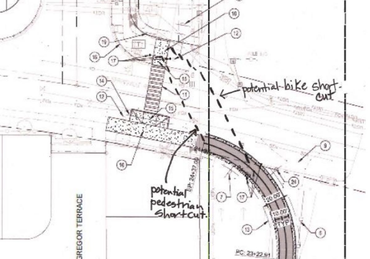
(Graphic: WH Pacific)
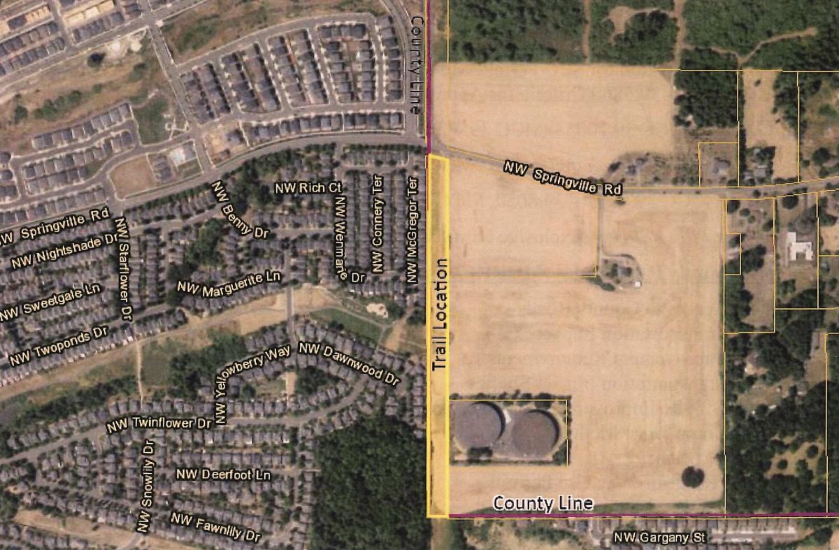
The new path would be located in Multnomah County on land owned by the Bonneville Power Administration that’s currently zoned for farm use only. As such, THPRD (which operates in Washington County) had to apply for a conditional use permit with the Multnomah County Land Use Planning Division.
“I am appalled county staff would produce a 60-page report and develop recommendations without ever consulting with the [Multnomah County Bicycle and Pedestrian Citizen Advisory Committee].”
— Andrew Holtz
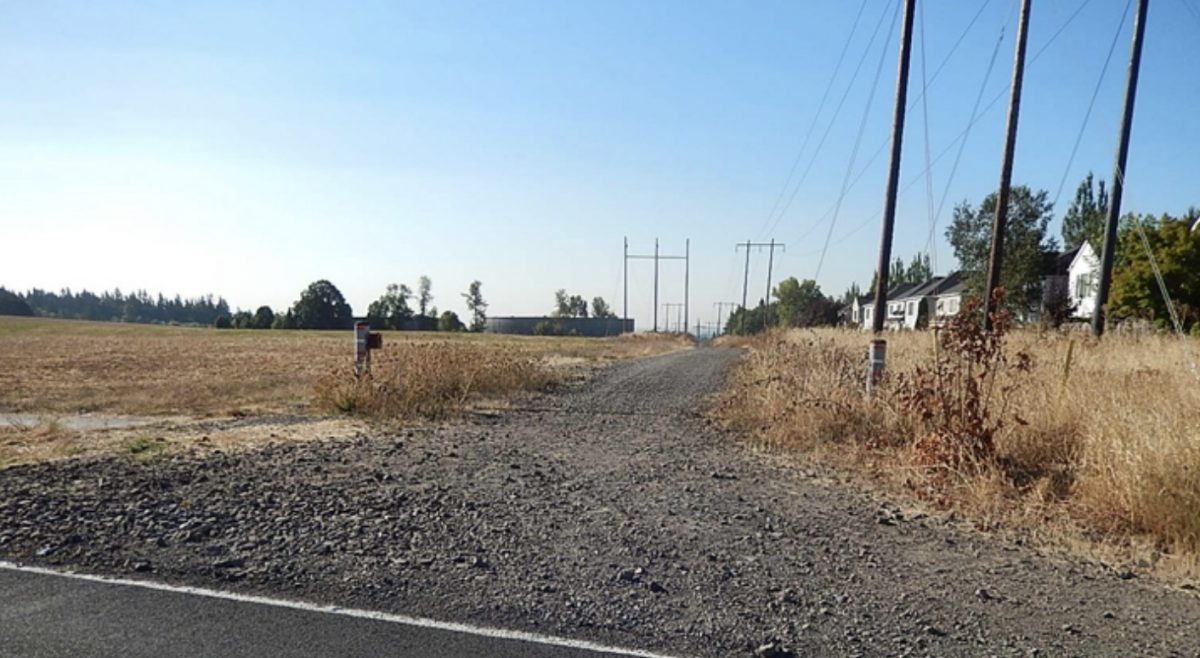
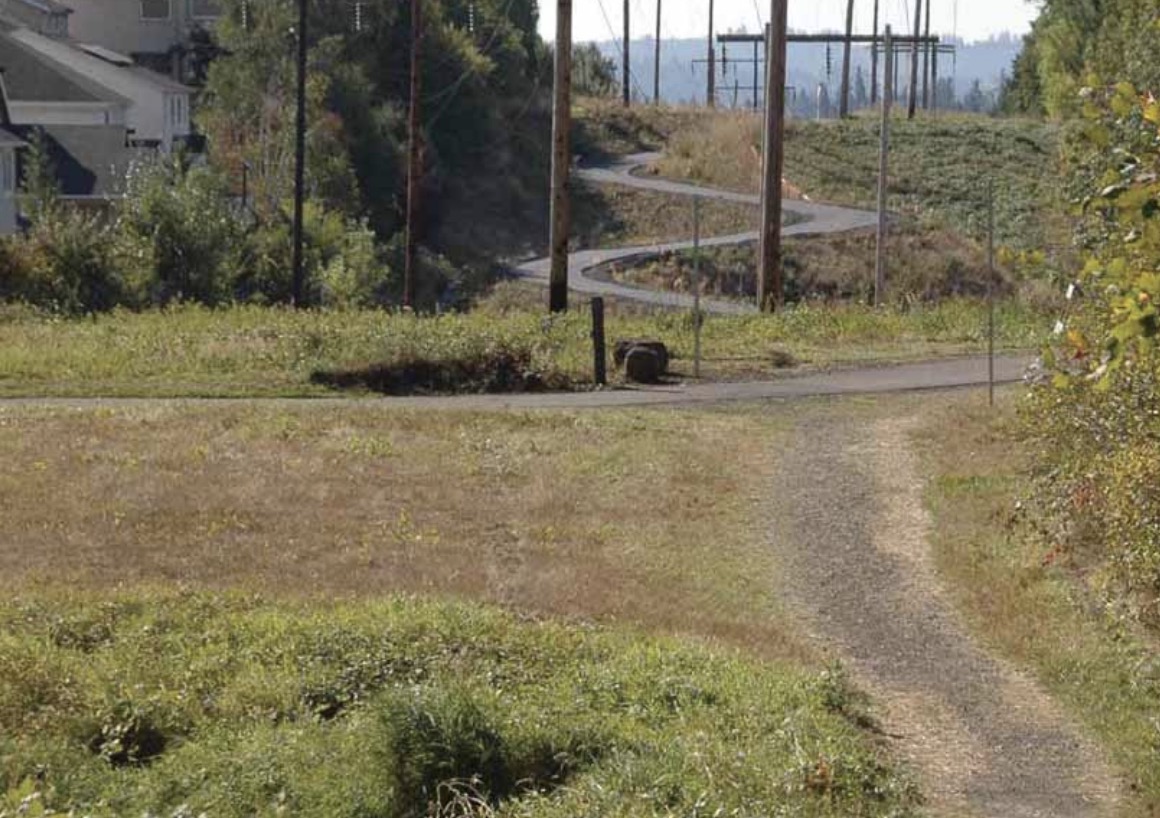
As proposed by THPRD, the path would be used by an estimated 366 people per day and would be 10-feet wide and have a 2-foot wide gravel shoulder. It would run north-south between the Rock Creek Trail and Springville Road with Kaiser Woods Natural Area to the west and a farm to the east. The location already has a gravel road that’s used by walkers and bikers. (I’ve ridden it several times because it makes a safer and more fun connection than nearby roads.) As currently designed, the project would also build a new crossing at Springville Road to connect to paths north of the street that have been built as part of recent residential construction (the area around this proposed path is booming).
Andrew Holtz has been a Multnomah County cycling advocate for decades and has been a member of the County’s Bicycle and Pedestrian Citizen Advisory Committee for 17 years. He emailed me last night (speaking for himself and not the committee) to say it’s “infuriating” that a land-use hearing on such an important project would take place without the committee’s knowledge.
Holtz has ridden on the existing road and said he’s excited for the changes this project would bring. “It seems obvious to me that improving this trail segment would benefit both the safety and comfort of people walking and bicycling in this area,” he said, “especially since it would connect several existing trails in the area.”
Advertisement
“But aside from the merits of the project,” he continued, “I am appalled county staff would produce a 60-page report and develop recommendations without ever consulting with the MCBPCAC [Multnomah County Bicycle and Pedestrian Citizen Advisory Committee].” Holtz wants the county to delay making any binding recommendations until the project can be reviewed by the committee.
“At present, Land Use Planning is unable to recommend approval of the application based upon the evidence in the record— from Multnomah County staff report
Unfortunately Holtz has been told that there isn’t time for the hearing to be pushed back. According to THPRD’s consultant on the project, they contacted Multnomah County more than a year ago but county staff never got the project onto the committee’s agenda. If the committee had a chance to discuss the proposal, they might have been able to work through the concerns from County land-use planning staff.
Asked why this hearing wasn’t on the committee’s agenda, Multnomah County spokesman Mike Pullen said, “[The project] is not part of the County’s Transportation program, which the committee provides input on. The County does not bring typically bring land use cases to its Bicycle and Pedestrian Citizen Advisory Committee… The trail segment proposed by Tualatin Hills Parks & Recreation District is not a Multnomah County project and is before the hearings officer. The County’s Transportation Division has no jurisdiction over the proposed trail.”
And Friday’s hearing can’t be rescheduled, because the public has already been notified. Pullen said state law requires that land use decisions be made within a certain time frame, which prevents moving the hearing to a later date. “Any citizen, including committee members, are welcome to attend the hearing or provide comment on the proposal,” he added.
According to their staff report (PDF) Multnomah County has decided that the project’s permit application fails to meet the goals of their Comprehensive Plan by several measures.
The county’s report says the estimated number of 366 trips, “could be inconsistent with neighboring rural land uses.” On a related point, the county says the project must “primarily serve the needs of the rural area” which they interpret as serving at least 51% of “rural users”. “No data has been provided to support that the Trail will primarily serve the needs of the rural area,” the report reads. “No evidence has been provided as to the number of rural residents from the nearby Multnomah County rural areas that will use the Trail.”
The county also listed a safety concern with the proposed new crossing of Springville Road (as seen in the graphic from the report): “Planning staff is uncertain what measures will prevent pedestrians and bicyclists from shortcutting the path before the controlled crosswalk which could lead to unpredictable crossings inconsistent with the proposed signaled crossing design located in Washington County.”
In addition to those concerns, the report concludes that THPRD hasn’t done enough to mitigate potential environmental impacts of the project, isn’t planning to plant enough trees and shrubs, and wants to erect too many freestanding signs along the path. Multnomah County also prefers a different alignment that would keep the path fully inside Washington County and be routed through a natural area and residential neighborhoods.
At Friday’s hearing, Multnomah County Land Use Planning Division staff will tell the hearings officer that they don’t approve of the current application. They plan to share a list of recommended changes to the proposal that could lead to approval.
The case will be decided by a third party land use hearings officer. The hearings officer hears public testimony at the hearing, considers the facts of the case, and then renders the County’s final land use decision. That decision can be appealed to the Oregon Land Use Board of Appeals (LUBA).
The hearing takes place Friday August 23rd in Room 103 at Multnomah County Land Use Planning Division Office (1600 SE 190th Avenue in Portland). If you care about this project and want to submit comment, email Multnomah County Deputy Planning Director Adam Barber adam.t.barber@multco.us.
— Jonathan Maus: (503) 706-8804, @jonathan_maus on Twitter and jonathan@bikeportland.org
Never miss a story. Sign-up for the daily BP Headlines email.
BikePortland needs your support.






Thanks for reading.
BikePortland has served this community with independent community journalism since 2005. We rely on subscriptions from readers like you to survive. Your financial support is vital in keeping this valuable resource alive and well.
Please subscribe today to strengthen and expand our work.
Interesting that such an obvious development would lead to so much controversy.
I’ve ridden that dirt road too, as it’s directly adjacent to the Kaiser Woods Natural Area, which is one of the few places in our district that I can ride on dirt with my kids (at least until THPRD paves it over, which wouldn’t surprise me at all). I hope they can move forward with this alignment — we don’t need a 10-foot-wide path going through the middle of the natural area.
I can say for certain that I would have used the proposed trail and Multnomah county needs to get over themselves on this one. that being said, THPRD could have planned this in on the Washington County side of the line if they had any foresight. The existing gravel path is large rocks and very annoying to ride.
I’ve ridden that trail while on the way out to North Plains (blech) and beyond. Why does this need to be paved?
It doesn’t, but it connects two paved paths frequently ridden by small children.
So normal people can use it.
I wrote some amazing songs but Chris, I’m just like you! I’m a normal guy!
Unless this path is less dirt and more unpassable-to-mere-mortals boulders since I was last on it, I still fail to see what the problem is.
Actually after giving those pics a good second look, you and Dan A are correct, that trail is entirely impassable. I wonder if the two people in the photo made it to their destination or if they had to turn back.
Those people are on foot. I bet it’s decidedly less fun in a wheelchair.
Perhaps you can make the case for why a 1/2 mile section of dirt and rock that connects to the future Westside Trail and provides a safer alternative to Kaiser Road should NOT be paved?
I wish we could connect the power-line access north of there from Springville to Old Germantown Road. That would provide a low-stress route to Skyline that did not involve riding up Springville or though those nasty hairpins on Germantown between Kaiser and Old Germantown.
If we cared about physical activity and recreation as a region, we would have paved and unpaved trails everywhere. Alas, people seem to care more about driving giant vehicles around to buy things they don’t need, spectate at sportsball games, etc.
Sounds like MultCo is mainly ticked off that WashCo is designing an amenity for WashCo residents on MultCo’s land! (all of those comments about how the trail fails to benefit the _rural_ population). Yes, the trail will mainly be used by the WashCo residents who live right next to it, but ultimately it will benefit *everyone* who lives in the greater Portland area and wants to roll there on a bike, skateboard, wheelchair, etc. MultCo officials, get over yourselves and figure out a way to approve this trail!
Time to write your elected multco board member and let them know that land use and transportation policy are the same thing?
MultCo has always been inconsistent with their transport advocacy, planning. It just depends on what commissioner gets appointed to JPACT. Then they pick their pet projects based on electorate wins for next cycle. MultCo Commissioners get paid more then Representatives or Senators in Salem. They often times ignore volunteer committees unless it’s their pet project. Or they just don’t care. That’s why I’m very concerned that the new Metro Bond community involvement is now being split into county boundaries. This will
Surely exasperate the acrimony these counties have for each other and result in less ideal projects that cost the entire region more. Who’s pay scale do we ask? IDK but how does MultCo get away with ignoring their own committees? Somehow volunteer committees are easier to ignore, but they are usually the smartest most passionate people in the room.
They world burns in bureaucracy.
That something so trivial and obvious causes this much debate is not surprising but yet another sign that the human species is heading towards self imposed extinction. What is most laughable is the concern over serving “rural residents”. Are they not aware these fields and rural areas will be large swaths of mostly asphalt subdivisions in 20 years?
As a Washington County resident who lives in a neighborhood adjacent to the proposed trail, there is no question this would improve the safety of residents of both counties who would use this path to cross Springville Road.
In my opinion, an equally pressing project would be to connect Saltzman Rd west of Skyline to the Rock Creek Greenway Trail or other trails system which would provide a safe way to climb or descend the west hills instead of using Springville. I’ve searched for information as to the status of this proposed trail connection but haven’t been able to find anything. Jonathan Maus – are you aware of any developments with the project?
If it helps, Germantown->Old Germantown, Thompson, Old Cornelius Pass->Skyline, and Rock Creek are better ways to get up to Skyline than Springville.
Dan A – thanks for the info – I know the area well. For commuting from my area, Springville is by far the most efficient route at the current time. 😉
UPDATE: The Hearings Officer APPROVED
Thanks for the information Holtz! 🙂 Are you aware of any links or where one could find posted information about the details about the trail/ruling?
I believe the approval will be posted at https://multco.us/landuse/public-notices, but it’s not up as I write this. The original staff report is at https://multco.us/file/82911/download That’s the report that was just overruled. The Tualatin Hills Parks & Rec project page is at http://www3.thprd.org/parks-in-progress/bethany-creek-trail/
UPDATE: The Hearings Officer issued his ruling APPROVING the trail segment application today (10/3/19). Nice to get a win.
It is has been paved this week.